

The Abandoned Mine Inventory of the United States—A Brief Summary
Links
- Document: Report (2.33MB pdf) , HTML , XML
- NGMDB Index Page: National Geologic Map Database Index Page (html)
- Download citation as: RIS | Dublin Core
The mining industry has supplied essential commodities to the United States since its founding. Today, mines are well regulated to help protect local communities and the environment; however, many historic mines were operated before modern environmental laws and regulations and were simply abandoned when production ceased. Mines have different types of workings, such as shafts, open pits, and tunnels; these types of workings are referred to as mine features, and an individual mine may have dozens of such features. Consequently, there are hundreds of thousands of abandoned mine features in the United States. Some of the features pose physical safety hazards, such as open shafts that people could fall into or tunnels that could collapse. Open features can be covered with closures such as bat grates, which mitigate those hazards and continue to allow access for wildlife (fig. 1). Abandoned mine features may also pose environmental hazards, such as the production of acid mine drainage: highly acidic water that contains heavy metals (fig. 2). As of 2025, there is no comprehensive national inventory of abandoned mine features and the physical and environmental hazards they present, so the total risks and liabilities from abandoned mine features in the United States is unknown.
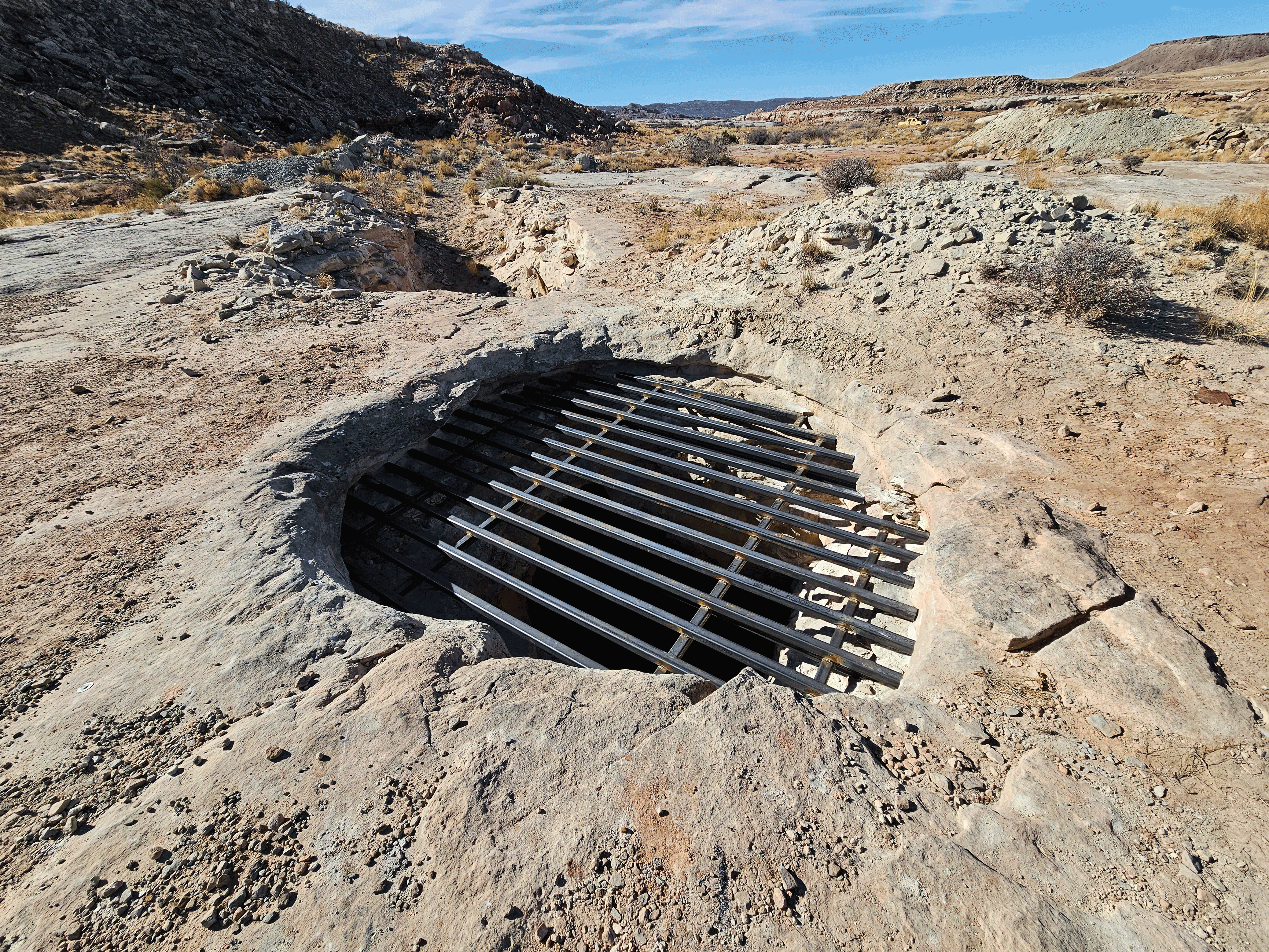
Photograph of a mine shaft in Utah that the U.S. Department of Energy’s Defense-Related Uranium Mines program safeguarded with a bat grate. The closure prevents human entry and wildlife entrapment while preserving habitat for bats. Photograph by Environmental Protection Services (Nevada).
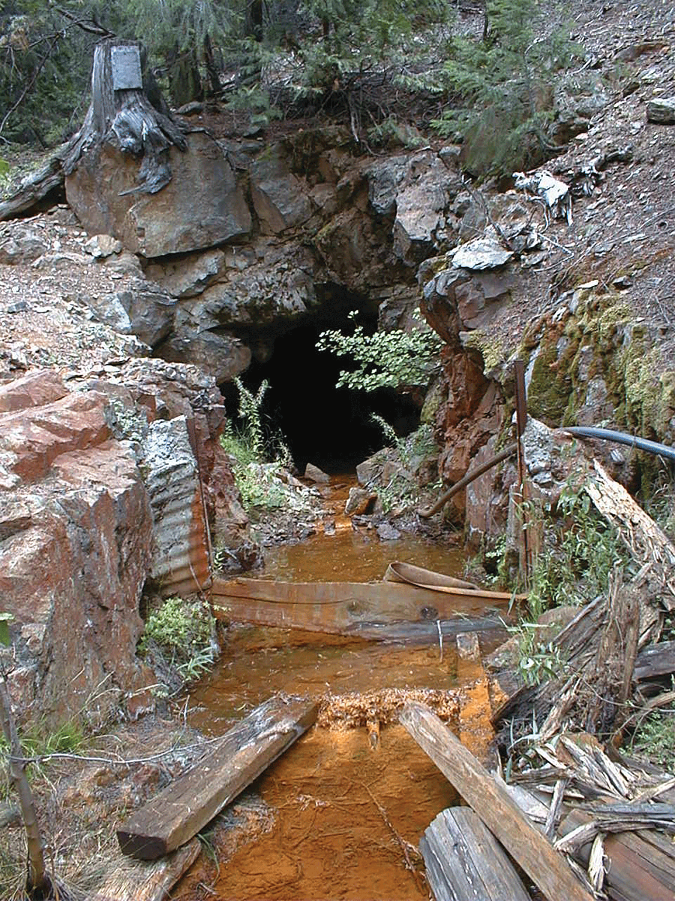
Photograph of acid mine drainage coming from an abandoned mine in Sierra County, California. Photograph by California Department of Conservation, Abandoned Mine Lands Unit staff.
The National Abandoned Mine Database
The 2021 Bipartisan Infrastructure Law, formally called the Infrastructure Investment and Jobs Act of 2021 (Public Law 117–58; 135 Stat. 1093), requires the Secretary of the Interior to establish a program to inventory abandoned hard-rock mines in the United States (Sec. 40704). The Department of the Interior’s Office of Environmental Policy and Compliance asked the U.S. Geological Survey’s Mineral Deposit Database project (USMIN; https://www.usgs.gov/USMIN) to use existing data sources to build an inventory of all individual abandoned mine features in the United States, including those from metallic mineral deposits, industrial minerals, and coal. In addition to feature locations, this new database documents the surface land management agency, associated physical and environmental hazards, and any completed mitigation efforts. This information will improve risk assessment and support land management efforts, including hazard mitigation, ecosystem restoration planning, and reclamation. This fact sheet provides a brief overview of USMIN’s collaborative efforts with Federal, State, and Tribal agencies to build a comprehensive and authoritative national inventory of all types of abandoned mine features.
A Brief History of Abandoned Mine Inventories in the United States
In 1977, the United States enacted the Surface Mining Control and Reclamation Act of 1977 (Public Law 95–87; 30 U.S.C. 1201 et seq.), which collects a per-ton fee from coal mines to fund reclamation of abandoned coal mines. The Office of Surface Mining Reclamation and Enforcement transfers funds to State and Tribal agencies annually for addressing environmental and physical safety problems at abandoned coal mines, and these funds have been used for many important reclamation projects. The Office of Surface Mining Reclamation and Enforcement also maintains an inventory of abandoned coal mine lands that is populated by State and Tribal agencies. However, there is little Federal funding to inventory and reclaim abandoned metallic mineral and industrial mineral mine features in the United States.
In many places, there is a great deal of local knowledge about abandoned coal and non-coal mine features. Some State, Federal, and Tribal agencies have databases that document the abandoned mine features on their land. But other agencies do not have such databases, have records in paper files, or have incomplete records that only partially document abandoned mine features. A clear need therefore exists for a truly comprehensive database that is digital, is nationwide in scope, and includes abandoned mine features for all mined commodities: coal, metals, and industrial minerals.
Building the Database Structure
The USMIN project collaborated with State, Federal, and Tribal agencies in 2022 to build an abandoned mines database structure that is based on individual mine features and can be used for the entire Nation. Each agency has its own mandates that determine what must and should be included in its database; therefore, our goal with the USMIN abandoned mines database was to build a database structure to host the most essential information that is common across most agency databases, with the simplest possible structure. The USMIN database has two feature classes: points and polygons. The database also has three tables: hazards, mitigation, and references. The point feature class contains location information, feature type, commodity group, and mine name. We use the location to derive data such as mining district, surface land management agency (for example, private, Bureau of Land Management, State), or topographic map name from publicly available State and national datasets. The polygon feature class captures the areal extent of three-dimensional features such as open-pit mines. The hazards table captures information about environmental and physical safety hazards for each feature, and the mitigation table documents any past mitigation and the final cost for that mitigation if known. The database does not include information on projected mitigation costs, because those costs may change and are best managed by the Federal, State, and Tribal agencies. Where data are compiled from publicly available sources, those sources are provided in the appropriate tables, and the reference table provides full citations.
Populating the Database and Mapping the Information
To populate the database, USMIN is collaborating with Federal, State, and Tribal agencies that are willing to share their databases. After USMIN acquires these data, we translate those records into the USMIN database structure. As part of this process, we review individual records from those agencies and actively communicate with the data provider to resolve any questions. This serves as an independent quality assurance/quality control check that many agencies find helpful.
Because of the different responsibilities of different agencies, it is often necessary to acquire data from multiple agencies to complete the database record for an individual feature. For example, in many places, physical safety hazards and environmental hazards are tracked by different agencies. Similarly, a State may have different databases for coal, metallic minerals, and industrial minerals, and different agencies may be responsible for building and maintaining those databases. Therefore, several databases may be required to populate records. Our goal is to build a living database that will be maintained by USMIN and periodically updated with new data from Federal, State, and Tribal agencies.
Many agencies do not want the specific location and other granular data for individual mine features to be publicly available because those data could be used to locate and explore hazardous underground workings or vandalize historic mine buildings. Therefore, USMIN will not publish specific location information of any abandoned mine workings, and the detailed national abandoned mine feature database will not be publicly available. However, USMIN will publish derivatives of the data that consolidate information at different scales. For example, we can produce maps that show the number and type of abandoned mine features in each congressional district or county of a State, or the number of features in watersheds where acid mine drainage from abandoned mine features is a risk.
Summary
The USMIN project is collaborating with Federal, State, and Tribal agencies to build a comprehensive 21st century geospatial database that documents the location, physical safety hazards, and environmental hazards of abandoned mine features throughout the United States, and the work that has been completed to mitigate those hazards. The progress and potential of the USMIN project are enhanced by the gracious support of our partners across the country.
Acknowledgments
We thank the Office of Environmental Policy and Compliance of the U.S. Department of the Interior for funding this work. We also thank Environmental Protection Services (Nevada) for supplying figure 1, and the California Department of Conservation, Abandoned Mine Lands Unit for supplying figure 2.
For additional information, visit
Disclaimers
Any use of trade, firm, or product names is for descriptive purposes only and does not imply endorsement by the U.S. Government.
Although this information product, for the most part, is in the public domain, it also may contain copyrighted materials as noted in the text. Permission to reproduce copyrighted items must be secured from the copyright owner.
Suggested Citation
Mauk, J.L., Karl, N.A., Pierson, J.S., and San Juan, C.A., 2025, The abandoned mine inventory of the United States—A brief summary: U.S. Geological Survey Fact Sheet 2025–3003, 2 p., https://doi.org/10.3133/fs20253003.
ISSN: 2327-6932 (online)
ISSN: 2327-6916 (print)
Study Area
| Publication type | Report |
|---|---|
| Publication Subtype | USGS Numbered Series |
| Title | The abandoned mine inventory of the United States—A brief summary |
| Series title | Fact Sheet |
| Series number | 2025-3003 |
| DOI | 10.3133/fs20253003 |
| Publication Date | March 14, 2025 |
| Year Published | 2025 |
| Language | English |
| Publisher | U.S. Geological Survey |
| Publisher location | Reston VA |
| Contributing office(s) | Geology, Geophysics, and Geochemistry Science Center |
| Description | 2 p. |
| Country | United States |
| Online Only (Y/N) | N |