

The 3D Elevation Program—Supporting Connecticut’s Economy
Links
- Document: Report (586 KB pdf) , HTML , XML
- Download citation as: RIS | Dublin Core
Introduction
Connecticut has a diverse, largely forested landscape characterized by hills and low mountains in the Western Upland, hills in the Eastern Upland, ridges and broad valleys in the Central Lowland, and many beaches and harbors along the coast of Long Island Sound. Connecticut is manufacturing and service focused, ranking almost highest among the 50 States in the United States in personal income per capita (Hoyt and others, 2024). Due to Connecticut’s dense population, many people, especially the approximately 60 percent living near the coast, may be affected by climate-driven disasters. High-quality elevation data can inform the activities of many nongovernmental organizations and municipal and academic entities statewide, resulting in substantial economic impact. Government at the State and local levels relies on these data to support regulatory permitting, resource and infrastructure management, and various engineering and planning-level analyses. Critical applications that meet the State’s management needs depend on light detection and ranging (lidar) data that provide a highly detailed three-dimensional (3D) model of the Earth’s surface and aboveground features.
The 3D Elevation Program (3DEP; refer to sidebar) is managed by the U.S. Geological Survey (USGS) in partnership with Federal, State, Tribal, U.S. territorial, and local agencies to acquire consistent lidar coverage at quality level 2 or better (table 1) to meet the many needs of the Nation and Connecticut. The status of available and in-progress 3DEP baseline lidar data in Connecticut is shown in figure 1. 3DEP baseline lidar data include quality level 2 or better, 1-meter or better digital elevation models, and lidar point clouds, and must meet the Lidar Base Specification version 1.2 (https://www.usgs.gov/3dep/lidarspec) or newer requirements. The National Enhanced Elevation Assessment (Dewberry, 2012) identified user requirements and conservatively estimated that availability of lidar data would result in at least $4.40 million in new benefits annually to the State. The top 10 Connecticut business uses for 3D elevation data, which are based on the estimated annual conservative benefits of 3DEP, are shown in table 2.
Table 1.
Data quality levels, pulse spacing, and pulse density. Quality level 2 or better lidar data meet 3DEP requirements.[Specifications for quality level 0 (QL0) are from Heidemann (2012, p. 3 and table 1); for quality levels 1 and 2, specifications are from Sugarbaker and others (2014, table 1). In the quality level column, QL0 represents the highest level of quality. RMSEz, root mean square error in the elevation (z) dimension; cm, centimeter; m, meter; pls/m2, first return pulses per square meter; ≤, less than or equal to; ≥, greater than or equal to]

Map of Connecticut showing status of 3D Elevation Program (3DEP) baseline lidar data as of July 2024. Visit https://usgs.gov/NationalMap/LidarExplorer to find and download currently available data.
Table 2.
Conservative benefits estimates for the top 10 Connecticut business uses of the proposed 3DEP data identified in the National Enhanced Elevation Assessment (Dewberry, 2012).Status of 3DEP in Connecticut
In 2015, the Capitol Region Council of Governments, on behalf of all nine regional councils of governments, received a grant from the Connecticut Office of Policy and Management to fund the statewide acquisition of high-quality lidar through the Regional Performance Incentive Program. The grant also leveraged funding from the Connecticut Department of Transportation and the Connecticut Department of Emergency Services and Public Protection. In 2017, Connecticut took delivery of statewide coverage of quality level 2 lidar data (fig. 2). Connecticut is currently processing statewide 3-inch orthoimagery and quality level 1 lidar data having a minimum of 20 points per square meter (ppsm) along the coast and 15 ppsm elsewhere, having been acquired and delivered in the spring of 2023 and anticipated in 2026, respectively, and incorporated into 3DEP.
Coastal Zone Management
According to the Connecticut Department of Energy and Environmental Protection (2020), “the Connecticut Coastal Management Act (CMA), effectuated in 1980, is the centerpiece of the State’s comprehensive coastal resource management program, building upon existing and new authorities. Responsibility for CMA implementation is shared by State and municipal levels of government. The CMA delineates a coastal management boundary, statutory policies, standards, and implementation procedures and defines government management responsibilities.” Mapping intertidal zone elevations, sea-floor bathymetry, and upland topography and seamlessly integrating these data can inform effective coastal zone management (National Oceanic and Atmospheric Administration, 2012). Lidar has the potential to improve coastal hazards modeling, impervious surface identification and analysis, and development of resiliency plans and storm response, all of which can help to protect Connecticut’s shoreline as well as its tourism and fishing industries.
Flood Risk Management
The availability of high-quality statewide elevation data can substantially improve the accuracy of flood maps and help to reduce onsite data-collection costs associated with flood risk mapping projects. More-accurate flood maps based on high-quality elevation data can be used to improve emergency preparedness and response. Connecticut experiences significant storm events, such as in September 2021, when remnants of Hurricane Ida produced heavy rainfall in parts of the State. Comprehensive lidar coverage enables detailed modeling, including dynamic 3D models of the overflow from streams and other water bodies affected by large storm events, catastrophic dam failures, and coastal overland storm surges. Quality level 1 lidar data can provide an enhanced ability to predict surface-water movement and inundation in high-risk coastal areas. Communities and agencies can use this information to design improved evacuation route plans and better protect the public in the event of a disaster.
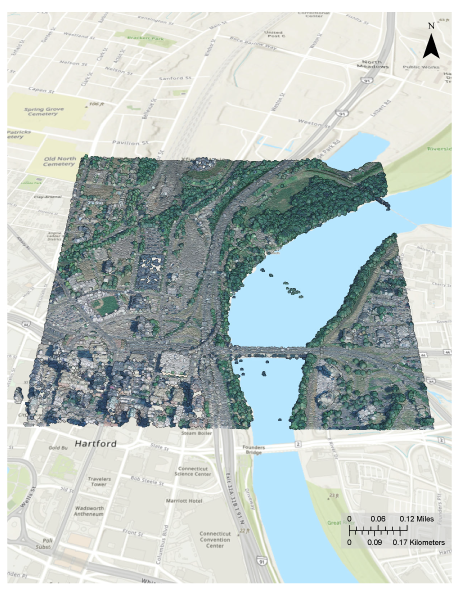
A sample of 3DEP lidar point cloud quality level 2 data as downloaded from The National Map (TNM), colored by imagery from the National Agriculture Imagery Program Plus (1 meter to 1 foot), also downloaded from TNM. The sample displayed is located in Hartford, Conn., where the Connecticut River flows under the Interstate 84 (U.S. Route 6) bridge.
Natural Resources Conservation
Connecticut is rich in natural resources and has a great diversity of habitat, landscapes, plant life, and wildlife. High-quality elevation data enable State, regional, and local governments to effectively implement natural resources conservation practices such as minimizing stormwater runoff, protecting tidal marshes and open space, siting trails, pursuing best agricultural practices, and identifying and protecting habitat, while reducing costs. Accurate lidar can increase Connecticut’s ability to protect natural resources and steward related recreational opportunities, both of which are economically relevant.
3D Elevation Program (3DEP)
The 3D Elevation Program is managed by the U.S. Geological Survey (USGS) on behalf of the community of Federal, State, Tribal, local, and other partners and users of elevation data. In response to growing needs for high-quality elevation data, the goal of 3DEP is to complete acquisition of nationwide light detection and ranging (lidar) data (interferometric synthetic aperture radar [IfSAR] data in Alaska) to provide the first-ever national baseline of consistent, high-resolution topographic elevation data—both bare-earth digital elevation models and 3D point clouds.
Benefits
-
• Economies of scale by acquiring data for larger areas.
-
• Predictable and flexible Federal investments that can reduce costs and allow better planning.
-
• Consistent national coverage that provides data for applications that span project, jurisdictional, and watershed boundaries.
-
• Simplified data acquisition that provides contracts, project management, quality assurance, and published data specifications.
-
• National benefits of $690 million per year conservatively, with the potential to generate $13 billion per year in additional benefits through applications that span the economy (Dewberry, 2012).
High-Quality Data and Products
3DEP lidar data provide coverage with a minimum of two points per square meter and a vertical error not to exceed 10 centimeters, measured as root mean square error in the elevation (z) dimension (RMSEz) (table 1). 3DEP baseline lidar data products include all data points collected (point clouds) and bare-earth digital elevation models with a 1-meter or better resolution. The USGS integrates the elevation data into The National Map. Data are available free of charge and without use restrictions. To download 3DEP products visit https://apps.nationalmap.gov/downloader/.
Ways to Participate
Participation in 3DEP is open to Federal, State, Tribal, U.S. territorial, and local government partners, as well as private sector partners, and offers the option to acquire even higher quality data. Partners may contribute funds toward projects managed by the USGS, or they may receive cooperative funds to manage their own projects. An annual Data Collaboration Announcement is the mechanism used to establish partner agreements. Organizations and the private sector may contribute existing data that meet 3DEP requirements. For more information refer to the 3DEP website at https://usgs.gov/3DEP/collaborate.
References Cited
Connecticut Department of Energy and Environmental Protection, 2020, Assessment and strategies of the Connecticut Coastal Management Program, 2021 to 2025 Enhancement Cycle, Section 309, Coastal Zone Management Act: Connecticut Department of Energy and Environmental Protection, Land and Water Resources Division, 103 p., September 2020, accessed July 18, 2024, at https://portal.ct.gov/-/media/deep/coastal-resources/coastal_management/final-ct-section-309-coastal-management-assessment-2021-to-2025.
Dewberry, 2012, National Enhanced Elevation Assessment final report (revised March 29, 2012): Fairfax, Va., Dewberry, 84 p. plus appendixes, accessed July 18, 2024, at https://www.dewberry.com/services/geospatial/national-enhanced-elevation-assessment.
Heidemann, H.K., 2012, Lidar base specification (ver. 1.2, November 2014): U.S. Geological Survey Techniques and Methods, book 11, chap. B4, 67 p. with appendixes, accessed July 18, 2024, at https://doi.org/10.3133/tm11B4.
Hoyt, J.B., Stolberg, I.J., and others, 2024, Connecticut: Encyclopaedia Britannica article, 2024, accessed July 18, 2024, at https://www.britannica.com/place/Connecticut.
National Oceanic and Atmospheric Administration, 2012, State Coastal Zone boundaries: National Oceanic and Atmospheric Administration, 4 p., accessed July 18, 2024, at https://coast.noaa.gov/data/czm/media/StateCZBoundaries.pdf.
Sugarbaker, L.J., Constance, E.W., Heidemann, H.K., Jason, A.L., Lukas, V., Saghy, D.L., and Stoker, J.M., 2014, The 3D Elevation Program initiative—A call for action: U.S. Geological Survey Circular 1399, 35 p., accessed July 18, 2024, at https://doi.org/10.3133/cir1399.
For Further Information:
Director, National Geospatial Program
U.S. Geological Survey, MS 511
12201 Sunrise Valley Drive
Reston, VA 20192
Email: [email protected]
USGS National Map Liaison:
Disclaimers
Any use of trade, firm, or product names is for descriptive purposes only and does not imply endorsement by the U.S. Government.
Although this information product, for the most part, is in the public domain, it also may contain copyrighted materials as noted in the text. Permission to reproduce copyrighted items must be secured from the copyright owner.
Suggested Citation
Harrington, L.E., and Walters, D.H., 2025, The 3D Elevation Program—Supporting Connecticut's economy: U.S. Geological Survey Fact Sheet 2025–3030, 2 p., https://doi.org/10.3133/fs20253030.
ISSN: 2327-6932 (online)
Study Area
| Publication type | Report |
|---|---|
| Publication Subtype | USGS Numbered Series |
| Title | The 3D Elevation Program—Supporting Connecticut's economy |
| Series title | Fact Sheet |
| Series number | 2025-3030 |
| DOI | 10.3133/fs20253030 |
| Publication Date | May 27, 2025 |
| Year Published | 2025 |
| Language | English |
| Publisher | U.S. Geological Survey |
| Publisher location | Reston, VA |
| Contributing office(s) | National Geospatial Program |
| Description | 2 p. |
| Country | United States |
| State | Connecticut |
| Online Only (Y/N) | Y |
| Additional Online Files (Y/N) | N |