

U.S. Geological Survey Streamgage Network in the Upper Colorado River Basin—Recording the Hydrologic History of the Western United States
Links
- Document: Report (8.53 MB pdf) , HTML , XML
- Related Work: Fact Sheet 2025-3036 Applying U.S. Geological Survey Science to Understand Effects to Water Supply in the Upper Colorado River Basin
- Download citation as: RIS | Dublin Core
Plain Language Summary
The Colorado River Basin provides critical water resources for millions of people. Streamgages have been collecting real-time data since the late 1800s and providing long-term information on hydrologic changes and processes in the basin. Advancements in monitoring technologies and data collection improve the understanding of complex processes affecting water quantity, quality, and availability for effective management across the basin.
Introduction
Water supply in the Western United States is an essential resource, and the collection of accurate and timely water information is fundamental to effectively managing water resources in the region. Efforts to document the hydrology in the Colorado River Basin are vital to life in the Western United States (Bureau of Reclamation [Reclamation], 2021). These efforts began as far back as the initial John Wesley Powell exploration of the Colorado River and its tributaries in the summer of 1869 (Powell, 1875). Shortly after, the U.S. Geological Survey (USGS) was created in 1879 (Rabbit, 1975), and the first USGS systematic measurement of streamflow began at the first streamgage, 08279500 Rio Grande at Embudo, New Mexico, in 1889 (LaVista, 2014).
During its 146-year existence, the USGS has served the citizens of the United States in many roles, notably through long-standing stewardship in water science. For example, the USGS has collected hydrologic information at strategic locations within the Western United States (figs. 1, 2) to support water resource management, flood forecasting and response, interbasin water transfers, hydropower generation, municipal and agricultural water supplies (fig. 3), food security, recreation, habitat preservation, international treaty obligations and river compact compliance, and the operation of major water-storage projects, including Lake Powell and Lake Mead bordering Utah and Arizona, and Nevada and Arizona, respectively (USGS, 2025a).

Photograph taken in 1961 of the U.S. Geological Survey 09188500 Green River at Warren Bridge, near Daniel, Wyoming streamgage. Photograph by U.S. Geological Survey.
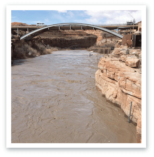
High flow at U.S. Geological Survey 09379500 San Juan River near Bluff, Utah streamgage. Photograph by U.S. Geological Survey.

U.S. Geological Survey staff making a streamflow measurement using an acoustic Doppler current profiler at U.S. Geological Survey 09076000 Maroon Creek near Aspen, Colorado streamgage. Photograph by U.S. Geological Survey.
Importance of Water Resources in the Colorado River Basin
The Colorado River has been described as the hardest working river in the Western United States because it has a 240,000 square mile drainage area that provides, among many other uses, water supplies for about 40 million people, 29 Tribes, 7 States, and 2 countries and supports irrigation of about 4.5 million acres of land, making it a critically important natural and economic resource for the Western United States. The Colorado River Basin includes parts of seven Western States—Arizona, California, Colorado, Nevada, New Mexico, Utah, and Wyoming—and is also shared with Mexico (Reclamation, 2021). The Upper Colorado River Basin is delineated by the area upstream from USGS streamgage 09380000, Colorado River at Lees Ferry, Arizona, which includes the Paria River Basin drainage area (fig. 4). The Upper Colorado River Basin is approximately 130,000 square miles, less than half the Colorado River Basin total area, and generates about 92 percent of the total streamflow in the Colorado River Basin (Lukas and Payton, 2020). Effective management of the complex water challenges within the Colorado River Basin depends upon comprehensive, accurate, and impartial water data available in real time because the shortfall in annual water supply and an extended drought of more than 20 years have strained reservoir storage and water security in the region (Scanlon and others, 2025).
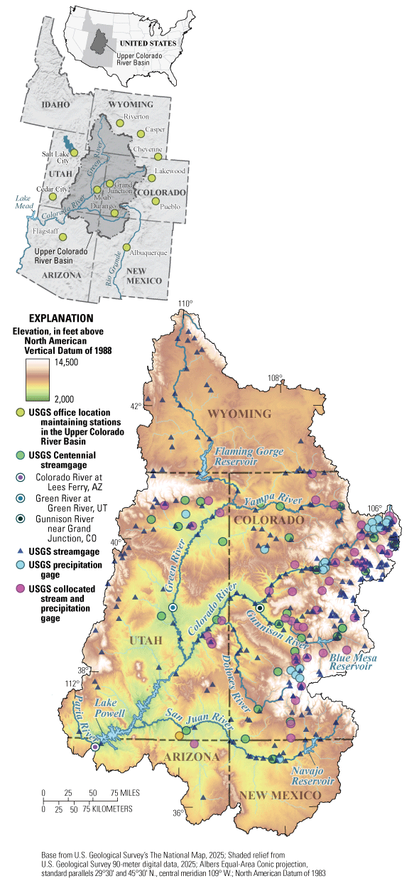
Map showing the 130,000 square mile extent and elevation range of the Upper Colorado River Basin, including locations of 352 U.S. Geological Survey (USGS) streamgages (including 33 with “Centennial” status), 71 precipitation gages, and 10 offices that maintain the hydrologic data collection network. Streamgage location information from USGS (2025b). CO, Colorado; UT, Utah; AZ, Arizona.
Hydrologic Data Collection in the Upper Colorado River Basin
The USGS operates a core network of real-time streamgages that provide long-term records of hydrologic conditions and deliver accurate documentation of the Upper Colorado River Basin’s water resources. The oldest USGS streamgages in the Upper Colorado River Basin are USGS 09315000 Green River at Green River, Utah, and USGS 09152500 Gunnison River near Grand Junction, Colorado (figs. 1, 4). These streamgages were put into service in 1894 and have continued to collect data for the past 130 years. As of July 30, 2025, the USGS operates 352 streamgages in the Upper Colorado River Basin, 33 of which are designated as “Centennial” streamgages because each has more than 100 years of recorded data (USGS, 2025b). The number of streamgages in the USGS network has substantially increased across the Upper Colorado River Basin during recent years with the potential for continued growth.
In addition to streamflow data, USGS hydrologic data collection is being enhanced in the Upper Colorado River Basin to include snowpack, soil moisture, water quality, groundwater, and atmospheric sensor networks. Precipitation information is a crucial complementary part of hydrologic datasets used for flood warning and is central to enhancing modeling and water balance initiatives for improved understanding of complex hydrologic processes, especially in mountainous regions (Bales and others, 2006; fig. 5A, B). Currently (March 2025), 71 precipitation gages, many collocated at various streamgages, operate within the Upper Colorado River Basin (fig. 4; USGS, 2025b), and there is the potential for additional network expansion. These data support improved understanding of emerging challenges in the Upper Colorado River Basin, including snowpack variability, wildfire effects, and salinity concentration (Day and Williams, 2025). The Upper Colorado River Basin data collection networks provide fine-scale, high-resolution data that integrate with the USGS National Water Monitoring Network and are centrally accessible through various databases and online tools (USGS, 2025a).
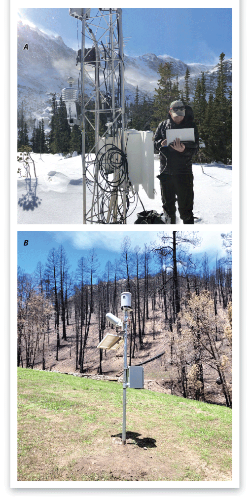
A, U.S. Geological Survey staff downloading data from 401723105400101 Andrews Creek Meteorological Station at Rocky Mountain National Park, Colorado. B, U.S Geological Survey precipitation gage deployed in a wildfire burn scar to be used for flood warning. Photographs by U.S. Geological Survey.
Innovation and New Monitoring Technology
Recent advancements in hydrologic monitoring technologies have resulted in the modernization of the USGS network in the Upper Colorado River Basin. The addition of new continuous measurements collected at existing streamgages, use of improved measuring devices for staff to deploy in the field, and more robust computational software all enhance data collection activities in the Upper Colorado River Basin. These combined advancements are improving data quality collected by the streamgages and increasing efficiency for field staff. Additional measurements collected at USGS streamgages include precipitation, surface velocity, water temperature, specific conductance, dissolved oxygen, turbidity, pH, and nitrate (USGS, 2025b). New sensor technologies deployed by field staff include noncontact velocity sensors, real-time cameras (fig. 6), underice sensors, submersible velocity measuring devices, light detection and ranging (lidar) sensors, and uncrewed aircraft systems. Combining enhanced data collection at USGS streamgages, coupled with additional measuring technologies for use by field staff, has resulted in an improved understanding of the hydrology of the Upper Colorado River Basin (USGS, 2025c; fig. 7A, B). The network now benefits from more accurate measurements at streamgages, better quality data during floods and droughts, better data collection during ice conditions, and overall improved operations that maximize data collection efficiency by using additional data streams to prioritize field campaigns.

U.S. Geological Survey staff making a streamflow measurement with an acoustic Doppler current profiler to calibrate the streamgage, surface velocity radar, and camera system at 09132095 Anthracite Creek above mouth near Somerset in Colorado, during snowmelt runoff. Photograph by U.S. Geological Survey.
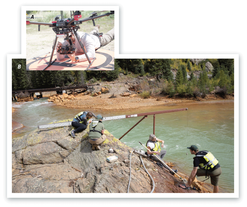
A, U.S. Geological Survey staff programming data collection sensors on an uncrewed aircraft system. B, U.S. Geological Survey staff servicing water quality data collection sensors at the streamgage 09359020 Animas River Below Silverton, Colorado. Photographs by U.S. Geological Survey.
Streamgage Network Funding Partners
Support for the USGS streamgage network within the Upper Colorado River Basin is generated from a mixture of federally appropriated and cooperator-funded dollars, ensuring the inclusion of many stakeholder interests to broaden data collection efforts. The streamgage network is funded through agreements with more than 75 Federal, Tribal, State, and local partners. These agreements leverage funding Congressionally appropriated to the USGS with cooperative funds provided by partners to support a robust and efficient network of data collection that aids water managers and others in making informed decisions regarding the protection of life and property, the environment, and the economy within the Upper Colorado River Basin (fig. 8).
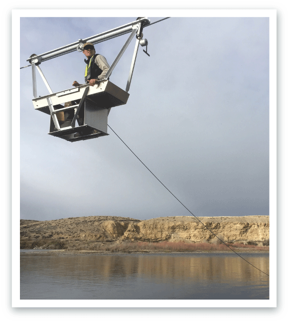
U.S. Geological Survey staff making an acoustic Doppler current profiler measurement from a cableway at U.S. Geological Survey 09211200 Green River below Fontenelle Reservoir, Wyoming streamgage. Photograph by U.S. Geological Survey.
References Cited
Bales, R.C., Molotch, N.P., Painter, T.H., Dettinger, M.D., Rice, R., and Dozier, J., 2006, Mountain hydrology of the Western United States: Water Resources Research, v. 42, no. 8, art. W08432, 13 p., accessed May 8, 2025, at https://doi.org/10.1029/2005WR004387.
Bureau of Reclamation [Reclamation], 2021, Colorado River Basin: Bureau of Reclamation, 2 p., accessed February 19, 2025, at https://www.usbr.gov/climate/secure/docs/2021secure/factsheets/Colorado.pdf.
Day, N., and Williams, C., 2025, USGS science to better understand factors affecting water supply in the Upper Colorado River Basin: U.S. Geological Survey Fact Sheet 2025–3036, 4 p., https://doi.org/10.3133/fs20253036.
LaVista, J., 2014, First USGS streamgage records 125 years of measuring New Mexico’s vital water resources: U.S. Geological Survey web page, access February 18, 2025, at https://www.usgs.gov/news/state-news-release/first-usgs-streamgage-records-125-years-measuring-new-mexicos-vital-water.
Lukas, J., and Payton, E., eds., 2020, Colorado River Basin climate and hydrology—State of the science: University of Colorado Boulder, 520 p., accessed February 19, 2025, at https://doi.org/10.25810/3hcv-w477.
Powell, J.W., 1875, Exploration of the Colorado River of the West and its tributaries—Explored in 1869, 1870, 1871, and 1872, under the direction of the Secretary of the Smithsonian Institution: U.S. Geological Survey Monograph, 291 p., accessed February 18, 2025, at https://doi.org/10.3133/70039238.
Rabbit, M.C., 1975, A brief history of the U.S. Geological Survey: U.S. Geological Survey General Information Product, 36 p., accessed February 18, 2025, at https://doi.org/10.3133/70039204.
Scanlon, B.R., Pool, D.R., Rateb, A., Conway, B., Sorensen, K., Udall, B., and Reedy, R.C., 2025, Multidecadal drought impacts on the Lower Colorado Basin with implications for future management: Communications Earth & Environment, v. 6, art. 214, 13 p., accessed May 8, 2025, at https://doi.org/10.1038/s43247-025-02149-9.
U.S. Geological Survey [USGS], 2025a, National water monitoring network: U.S. Geological Survey web page, accessed May 5, 2025, at https://www.usgs.gov/mission-areas/water-resources/science/national-water-monitoring-network.
U.S. Geological Survey [USGS], 2025b, USGS water data for the Nation: U.S. Geological Survey National Water Information System database, accessed July 30, 2025, at https://doi.org/10.5066/F7P55KJN.
U.S. Geological Survey [USGS], 2025c, USGS Next Generation Water Observing System (NGWOS): U.S. Geological Survey web page, accessed May 8, 2025, at https://www.usgs.gov/mission-areas/water-resources/science/next-generation-water-observing-system-ngwos.
For More Information about USGS water information in the Upper Colorado River Basin:
Arizona Water Science Center: https://www.usgs.gov/centers/arizona-water-science-center
Colorado Water Science Center: https://www.usgs.gov/centers/colorado-water-science-center
New Mexico Water Science Center: https://www.usgs.gov/centers/new-mexico-water-science-center
Utah Water Science Center: https://www.usgs.gov/centers/utah-water-science-center
Wyoming-Montana Water Science Center: https://www.usgs.gov/centers/wyoming-montana-water-science-center
Disclaimers
Any use of trade, firm, or product names is for descriptive purposes only and does not imply endorsement by the U.S. Government.
Although this information product, for the most part, is in the public domain, it also may contain copyrighted materials as noted in the text. Permission to reproduce copyrighted items must be secured from the copyright owner.
Suggested Citation
Forbes, B.T., Eddy-Miller, C.A., Rowland, R.C., Drukker, O.A., and Cordova, J., 2025, U.S. Geological Survey streamgage network in the Upper Colorado River Basin—Recording the hydrologic history of the Western United States: U.S. Geological Survey Fact Sheet 2025–3039, 4 p., https://doi.org/10.3133/fs20253039.
ISSN: 2327-6932 (online)
ISSN: 2327-6916 (print)
Study Area
| Publication type | Report |
|---|---|
| Publication Subtype | USGS Numbered Series |
| Title | U.S. Geological Survey streamgage network in the Upper Colorado River Basin—Recording the hydrologic history of the Western United States |
| Series title | Fact Sheet |
| Series number | 2025-3039 |
| DOI | 10.3133/fs20253039 |
| Publication Date | August 06, 2025 |
| Year Published | 2025 |
| Language | English |
| Publisher | U.S. Geological Survey |
| Publisher location | Reston VA |
| Contributing office(s) | Colorado Water Science Center |
| Description | 4 p. |
| Country | United States |
| State | Arizona, Colorado, New Mexico, Utah, Wyoming |
| Other Geospatial | Upper Colorado River basin |
| Online Only (Y/N) | N |