

Earthquake Probabilities and Hazards in the U.S. Pacific Northwest
Links
- Document: Report (10 MB pdf) , HTML , XML
- Version History: Version History (1 KB txt)
- NGMDB Index Page: National Geologic Map Database Index Page (html)
- Download citation as: RIS | Dublin Core
Plain Language Summary
Earthquakes and their cascading consequences pose a significant threat to the people, environment, infrastructure, and economy of the U.S. Pacific Northwest. The timing of previous earthquakes helps estimate the likelihood of future events.
Earthquakes in the U.S. Pacific Northwest
Subduction zones are formed when Earth’s tectonic plates collide and one plate is forced beneath the other. The U.S. Pacific Northwest is along the Cascadia Subduction Zone, where the Juan de Fuca Plate is thrust (or subducts) beneath the North American Plate. The Pacific Northwest is susceptible to three types of earthquakes: deep (intraslab) earthquakes, subduction zone (megathrust) earthquakes, and shallow crustal earthquakes. Historically, each earthquake type has caused significant damage to natural and built environments in northern California, Oregon, Washington, and southern British Columbia, Canada (referred to as “Cascadia”; fig. 1).
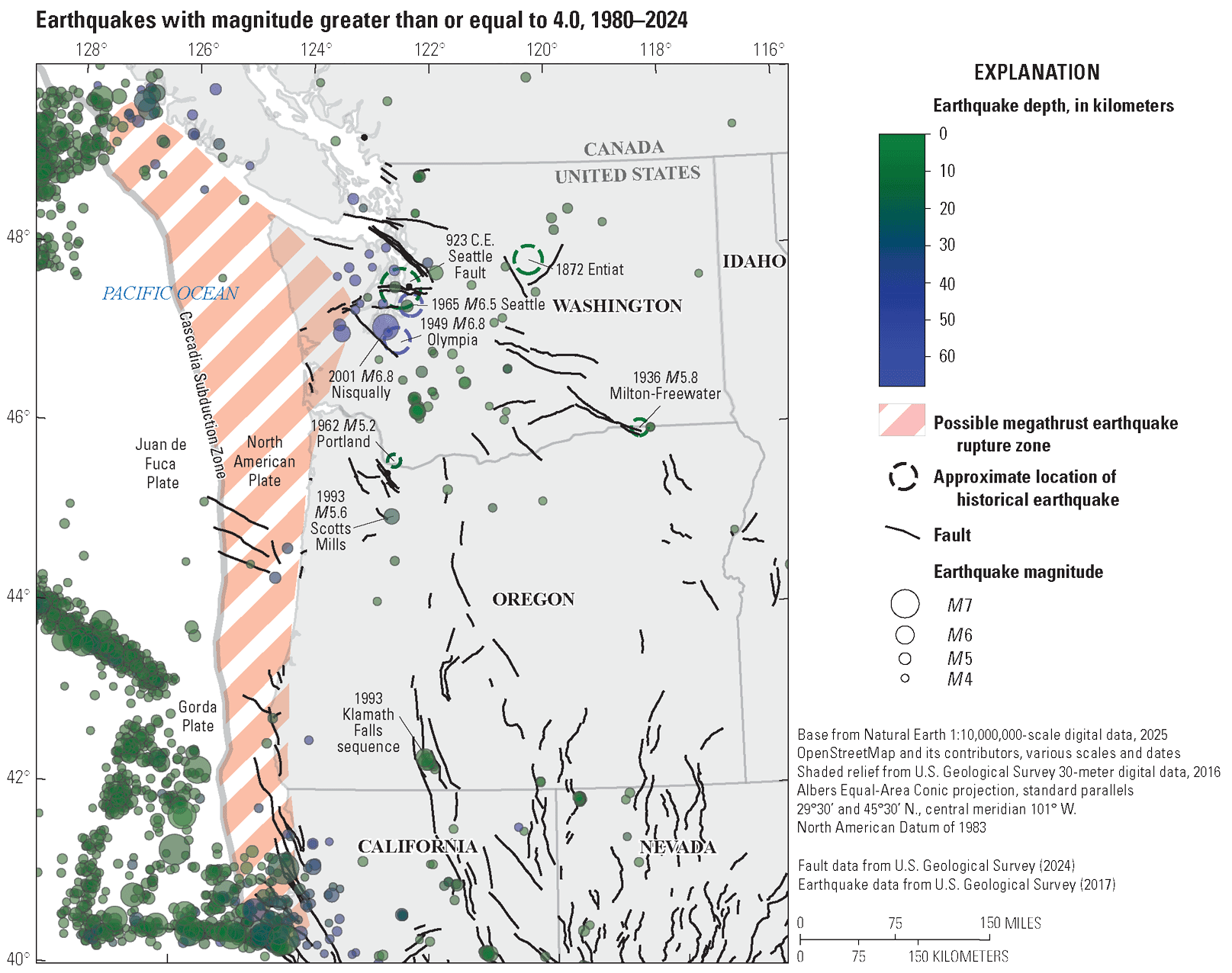
Map showing the U.S. Pacific Northwest and locations of earthquakes with a magnitude greater than or equal to 4 that occurred between 1980 and 2024 and notable earthquakes that occurred prior to 1980 in Washington and Oregon. Also shown is the possible rupture extent of Cascadia megathrust earthquakes and crustal faults included in the U.S. Geological Survey’s 2023 National Seismic Hazard Model (U.S. Geological Survey, 2024).
Determining the Likelihood of Future Earthquakes
For each of these types of earthquakes, earth scientists can use a variety of methods to estimate the probability of occurrence for future events. Catalogs of earthquakes and historical accounts are essential for estimating future probabilities; however, earthquake catalogs have short durations and may not adequately characterize large earthquakes with recurrence intervals of hundreds to thousands of years. Without a long-term observational record, paleoseismic investigations are often used to identify and date geological evidence of past large earthquakes. Present-day geodetic data may also help determine the rate of strain accumulation along faults and be used to estimate earthquake recurrence rates.
Earthquake probabilities are often computed assuming that earthquakes are time independent and there is no “memory” regarding when the last earthquake occurred. Assuming a time-independent (or “Poissonian”) model implies that an earthquake is equally likely to happen on any given day, whether an earthquake occurred the day before or hundreds of years ago. Given that earthquakes on a particular fault (or fault segment) result from strain accumulation over time, this is likely an incorrect assumption for individual faults. However, it is a straightforward and reasonable way of computing earthquake probabilities, particularly in areas where the dates of past earthquakes are uncertain or when evaluating the combined hazard from multiple faults collectively. Assuming a time-independent model, the probability (P) of an earthquake happening in a specified time interval (t) is , where e is Euler’s number (approximately 2.718) and is the mean recurrence time between events. Here, we give earthquake probabilities as a percentage chance in 50 years (that is, t=50 years), which is comparable to the lifetime of a typical building (fig. 2).
A more comprehensive overview of earthquake probabilities and seismic hazard in the United States is included in the U.S. Geological Survey’s National Seismic Hazard Model (NSHM; U.S. Geological Survey, 2024), which is used in building codes to protect life and property from future earthquake shaking.
Deep (Intraslab) Earthquakes
The most common type of moderate magnitude seismicity in the U.S. Pacific Northwest is deep earthquakes within the subducting Juan de Fuca Plate, which typically occur at depths of 25–40 miles (40–60 kilometers) beneath the surface. These events may be related to bending of the subducting slab or metamorphic reactions that release fluids as the slab descends. In Cascadia, intraslab earthquakes are most common beneath the Puget Sound region of Washington State. Notable deep earthquakes include the 1949 magnitude (M) 6.8 Olympia, 1965 M6.5 Seattle, and 2001 M6.8 Nisqually events (fig. 3; Cascadia Region Earthquake Workgroup, 2008). Since 1990, no intraslab earthquakes with a magnitude greater than or equal to (≥) 4 have been observed in northern or central Oregon, but this does not preclude future deep earthquakes. In southern Oregon and northern California, several intraslab earthquakes with an M less than 5 have occurred within the subducting Gorda Plate. Within the Puget Sound region, M≥6.5 deep earthquakes occur roughly every few decades and have caused significant damage to buildings and infrastructure, particularly close to the epicenter and in areas with shallow soft soils. Using the time intervals between the 1949, 1965, and 2001 deep earthquakes, we estimate a mean recurrence interval of 26 years (. The time-independent model indicates an 85-percent chance of a deep intraslab earthquake in the Puget Sound region in the next 50 years. If the next M≥6.5 deep instraslab earthquake in the Puget Sound region occurs within a few decades of the 2001 event, the 50-year probability of occurrence will remain approximately the same.
In the absence of a longer observational record, and because intraslab earthquakes do not leave a strong paleoseismic signature from which we can infer the ages of older events, these recurrence intervals may not be representative of future earthquake occurrence. In addition, global observations of intraslab earthquakes have documented events up to approximately (~) M8 (for example, the 2017 M8.2 Chiapas, Mexico, earthquake), indicating that future intraslab earthquakes in the U.S. Pacific Northwest could be larger than the 1949, 1965, and 2001 events.

Simplified sketches showing the 50-year probability of occurrence for various earthquake types.
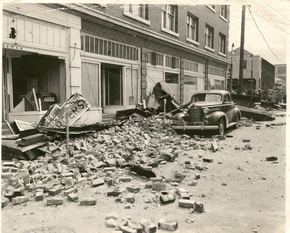
Photograph showing damage in Auburn, Washington (a suburb of the Seattle metropolitan area), caused by the 1949 deep intraslab earthquake. Photograph courtesy of the White River Valley Museum, used with permission.
Subduction Zone (Megathrust) Earthquakes
Subduction zone (megathrust) earthquakes occur on the interface between the Juan de Fuca and North American Plates. Despite a lack of observational records, the Cascadia Subduction Zone has an ~10,000-year history of large megathrust earthquakes constrained by a variety of geologic evidence, making it the most paleoseismically well-constrained subduction zone in the world. The geologic record includes evidence for coastal land-level change from earthquakes, tsunami inundation, landslides, and liquefaction, as well as turbidite deposits (submarine landslides and sediment flows) along the continental margin and in inland lakes. Indigenous oral histories provide further evidence for great earthquakes in Cascadia. Using dendrochronology to determine the time of death of trees from tectonic land-level change and seawater inundation along the outer coast and written records of a tsunami reaching Japan, scientists have determined that the last great Cascadia earthquake occurred on January 26, 1700, with an estimated magnitude between M8.7 and M9.2. Overall, paleoseismic evidence indicates that at least 19 great (M≥8) megathrust earthquakes have ruptured along most of the Cascadia coastline over the past ~10,000 years. Notably, there have been very few small-to-moderate magnitude earthquakes observed on the Cascadia megathrust.

Timeline showing deep earthquakes in the Puget Sound region with magnitudes greater than or equal to 6.5, based on the observational record.
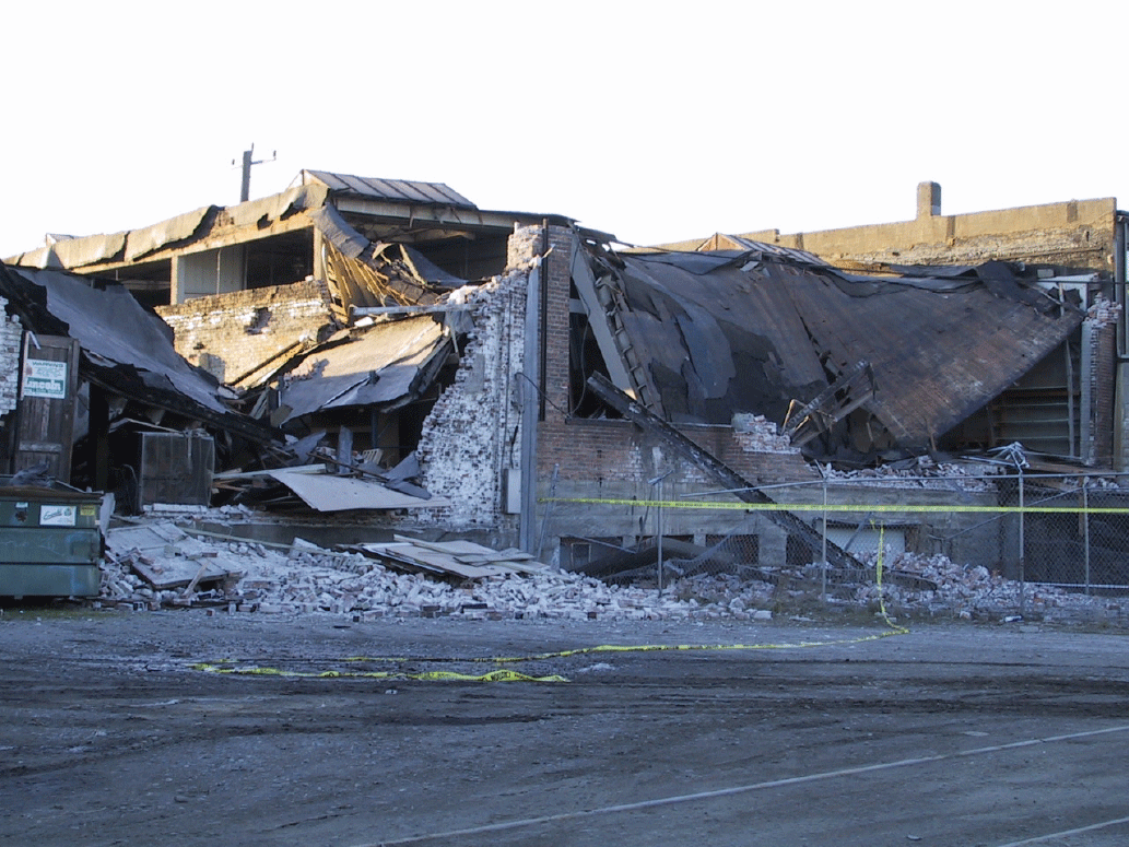
Photograph showing partial collapse of an unreinforced masonry building in the SODO neighborhood of Seattle, Washington, caused by the 2001 magnitude 6.8 Nisqually earthquake. Photograph by Kathy Troost, University of Washington, used with permission.
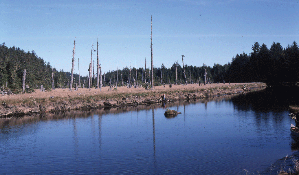
Photograph showing a ghost forest in Copalis, Washington. Tree-ring dating indicates that these trees died in the winter of 1699–1700, likely because of coastal subsidence and seawater inundation caused by the last great Cascadia Subduction Zone earthquake. Photograph by Brian Atwater, U.S. Geological Survey.
Full Margin Megathrust Earthquakes
The NSHM uses a recurrence interval of ~500 years for full margin (M~9) ruptures on the Cascadia megathrust. This ~500-year recurrence rate is based on independent paleoseismic observations of onshore coastal subsidence; tsunami deposits; and offshore and lake turbidites, ranging from California to Vancouver Island, British Columbia. This recurrence interval implies a 10-percent chance of another M~9 earthquake on the Cascadia Subduction Zone in the next 50 years using a time-independent recurrence model. If we assume a time-dependent Brownian passage-time distribution of earthquake occurrence (eq. 12 in Matthews and others [2002]), which considers that the last great Cascadia earthquake occurred in the year 1700, we find a 15-percent chance of an M~9 earthquake on the Cascadia Subduction Zone in the next 50 years. Although uncertainty exists regarding whether some of these hypothesized full margin ruptures (M~9) may instead be a series of partial margin ruptures (M~8) that are relatively closely spaced in time, individual sites along the coast would still experience a great earthquake (M≥~8) every ~500 years.
Partial Margin Megathrust Earthquakes
Within the geologic record, evidence exists for Cascadia megathrust earthquakes that are limited in their geographic extent along the coastline. These events have been interpreted as likely partial margin earthquakes (M~8) that only rupture along a portion of the coastline. The recurrence intervals of these earthquakes are difficult to constrain. In southern Cascadia, partial margin ruptures may occur every ~800–1,000 years, which implies an overall recurrence rate (combining partial and full margin ruptures) of ~300–350 years in southern Cascadia (fig. 4).

Hypothetical timeline showing the contribution of full margin (approximately every 500 years) and partial margin (approximately every 1,000 years) ruptures to an overall estimated recurrence interval of 330 years for magnitude 8–9 earthquakes in southern Cascadia.

Photograph showing earthquake damage to Molalla High School in Oregon after the 1993 magnitude 5.6 Scotts Mills earthquake. Photograph from The Oregonian, used with permission.
A time-dependent recurrence model indicates an ~30-percent chance of an M8+ earthquake occurring in southern Cascadia in the next 50 years (that is, either a full or partial margin rupture). However, it is not entirely clear how to apply a time-dependent rupture model in a region of the subduction zone that may host a range of earthquake magnitudes. Although some evidence exists for partial margin earthquakes in northern Cascadia, it is challenging to determine a recurrence interval for these events.
Crustal Earthquakes
Crustal earthquakes occur on faults within the shallow crust at depths of approximately less than or equal to 20 miles (~30 kilometers) from the surface. In the U.S. Pacific Northwest, crustal fault systems are commonly hidden by surficial deposits, water, vegetation, and urbanization. This, combined with relatively low crustal deformation and fault slip rates, makes it difficult to identify and study crustal faults in the Pacific Northwest.
In the populated Puget Sound region of Washington State, clockwise rotation of the Oregon coast block and northward migration of the Sierra Nevada block result in north-south compression on primarily east-west trending faults. Paleoseismic studies document numerous crustal fault earthquakes that have occurred in the Puget Sound region throughout the last several thousand years, including the 923–924 C.E. M7.5–7.8 Seattle Fault event (Black and others, 2023). When considering all Puget Sound region crustal fault sources in aggregate, researchers estimate an ~265-year recurrence interval for M≥6.5 crustal fault earthquakes. Using a recurrence interval of 265 years and a time-independent model indicates a 17-percent chance of an M≥6.5 crustal fault earthquake in the Puget Sound region in the next 50 years. This is roughly consistent with the seismicity rates for all mapped faults in the Puget Sound region from the 2023 NSHM; however, this may be an underestimate because of incomplete mapping of faults in the region or the occurrence of prehistoric earthquakes that failed to leave a surface expression.
The recurrence intervals of M≥6.5 crustal fault earthquakes can also be estimated using the frequency of occurrence for all recorded Puget Sound region crustal earthquakes with M≥4.0 between 1960 and 2024 (20 events, ranging from M4.0 to 5.4). Using a b-value (that is, a parameter describing the relative proportion of small to large earthquakes) appropriate for the western United States (b=0.8) yields an estimated recurrence interval of ~280 years for M≥6.5 earthquakes, similar to the paleoseismic estimates.
Perhaps the most well studied of the Puget Sound crustal fault systems is the Seattle Fault Zone. Using earthquake rates from the 2023 NSHM, we estimate a recurrence interval of ~1,000 years for M≥6.5 earthquakes on the Seattle Fault Zone. Using the time-independent assumption for earthquake recurrence indicates a 5-percent chance of an M≥6.5 Seattle Fault earthquake in the next 50 years.
Outside of the Puget Sound region, large earthquakes are also possible on inland crustal faults, but observational and paleoseismic constraints are extremely limited. In western Oregon, notable events include the 1873 M6.8 Brookings (near the Oregon-California border), 1962 M5.2 Portland, and 1993 M5.6 Scotts Mills earthquakes. Focusing only on the northern Willamette Valley in Oregon and using crustal fault earthquake rates from the 2023 NSHM, we calculate an ~800-year recurrence interval for M≥6.5 crustal fault earthquakes. This corresponds to a 6-percent chance of an M≥6.5 earthquake in the Portland or northern Willamette Valley region in the next 50 years.
In eastern Oregon and Washington, significant events include the 1872 M6.5–7 Entiat, Washington, and 1936 M5.8 Milton-Freewater, Oregon, earthquakes. Noteworthy earthquakes have also occurred in southeastern Oregon, where crustal fault systems are dominated by the tectonics of the Basin and Range Province and have resulted in significant earthquakes such as the 1993 Klamath Falls earthquake sequence, which included M6.0 and M5.9 events.
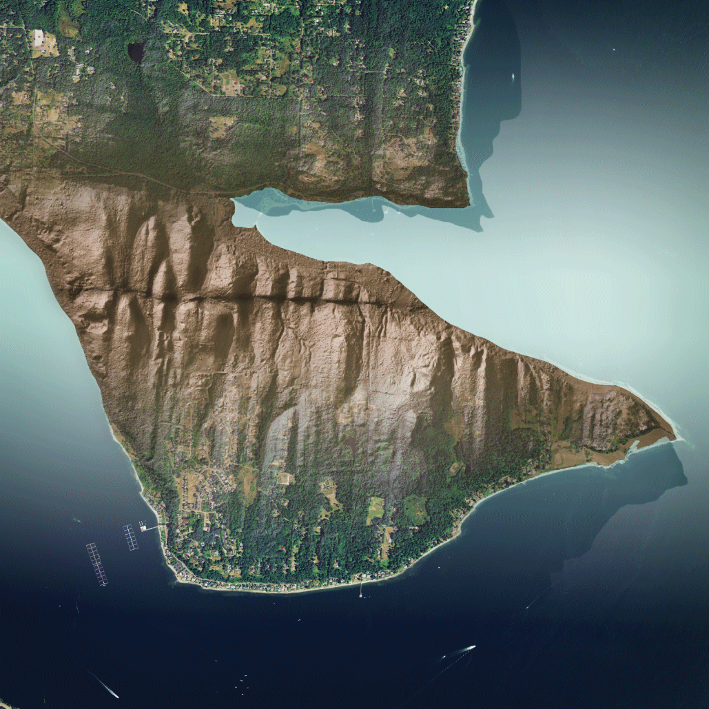
Blended and modified aerial hillshade image of Bainbridge Island, Washington, showing sharp breaks in topography from earthquake rupture on the Toe Jam Hill Fault, which is part of the Seattle Fault Zone. Images from Washington Geological Survey (Washington State Department of Natural Resources), used with permission.
Shallow Offshore Seismicity
Crustal fault earthquakes are also common in offshore areas and typically occur along plate boundaries, as well as in intraplate regions. Seismicity near the Mendocino Triple Junction, where the Pacific, North American, and Gorda Plates meet, is particularly common. This region experiences numerous M≥6.5 earthquakes, many of which can be felt on land. Because of the complex tectonics of this region, these earthquakes may occur on the Mendocino Transform Fault, or within the crust of the Gorda or North American Plates. Notable examples include the 1980 M7.2 and 2010 M6.5 Eureka earthquakes, the 1992 M7.2 Petrolia earthquake sequence, the 2022 M6.4 Ferndale earthquake, and the 2024 M7.0 offshore Cape Mendocino earthquake. In general, the Gorda Plate region experiences a few offshore earthquakes per decade (M≥6.5) within ~100 miles (~160 kilometers) of the coastline that are capable of being felt on land; however, the rate of offshore seismicity has been highly variable across the observational record.
Other Seismic Signals and Phenomena
Typical earthquakes occur over a span of seconds to minutes, but faults may also slip slowly over intervals of hours to years. In Cascadia, these episodes of slow fault slip and their associated seismic signal are often referred to as episodic tremor and slip (ETS). These events occur regularly in Cascadia (roughly every 8–22 months) and are imperceptible to humans. Because ETS in Cascadia occurs on the subduction interface downdip of the locked zone (that is, just beneath the part of the fault that is expected to rupture in a megathrust earthquake), it is of scientific and practical interest to understand the relationship between ETS and large megathrust events. Slow-slip events have been observed to precede megathrust earthquakes in Japan and Chile, but no known link exists between ETS and megathrust earthquake hazard in Cascadia.
The U.S. Pacific Northwest is also home to numerous active volcanoes. Deformation, magma, and gas movement within these volcano systems may lead to volcanic earthquakes. Although not always linked to an eruption, millions of small volcanic earthquakes accompanied the eruptions of Mount St. Helens in 1980 and 2004. The largest volcanic earthquakes recorded in the Cascade Range are M5+ events that occurred beneath Mount St. Helens in the 1980s.
Preparing for Future Earthquakes
Earthquakes can have a significant impact on the people, environment, infrastructure, and economy of the U.S. Pacific Northwest. In addition to ground shaking, earthquakes may trigger tsunamis, landslides, liquefaction, and land-level changes, among other hazards. Individuals and communities can take steps to prepare and mitigate their risk:
-
• Identify hazards and secure movable items in your home and workspace;
-
• Develop an emergency plan and supply kit based on local guidelines;
-
• Practice “Drop, Cover, and Hold On” to protect yourself during earthquake shaking;
-
• Familiarize yourself with local tsunami evacuation routes in areas where you live, work, and travel; and
-
• Participate in emergency preparedness drills (such as the Great ShakeOut; https://www.shakeout.org).
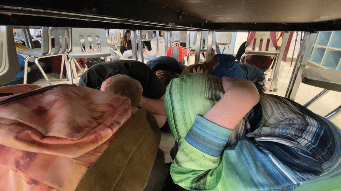
Photograph showing students under desks during an emergency earthquake drill recommended by the Great ShakeOut (https://www.shakeout.org). Photograph courtesy of the University of Washington College of the Environment, used with permission.
Acknowledgments
We thank John Vidale, Lydia Staisch, Joan Gomberg, Renate Hartog, Seth Moran, and David Applegate for helpful comments that improved this Fact Sheet.
Selected References
Atwater, B.F., Musumi-Rokkaku, S., Satake, K., Tsuji, Y., Ueda, K., and Yamaguchi, D.K., 2015, The orphan tsunami of 1700—Japanese clues to a parent earthquake in North America, 2d ed.: Seattle, University of Washington Press, U.S. Geological Survey Professional Paper 1707, 135 p. [Also available at https://doi.org/10.3133/pp1707.]
Black, B.A., Pearl, J.K., Pearson, C.L., Pringle, P.T., Frank, D.C., Page, M.T., Buckley, B.M., Cook, E.R., Harley, G.L., King, K.J., Hughes, J.F., Reynolds, D.J., and Sherrod, B.L., 2023, A multifault earthquake threat for the Seattle metropolitan region revealed by mass tree mortality: Science Advances, v. 9, no. 39, 9 p. [Also available at https://doi.org/10.1126/sciadv.adh4973.]
Bostock, M.G., Christensen, N.I., and Peacock, S.M., 2019, Seismicity in Cascadia: Lithos, v. 332–333, p. 55–66. [Also available at https://doi.org/10.1016/j.lithos.2019.02.019.]
Cascadia Region Earthquake Workgroup, 2008, Cascadia deep earthquakes: CREW—Cascadia Region Earthquake Workgroup website, accessed August 2025 at https://crew.org/wp-content/uploads/2016/04/cascadia-deep-eq-2008.pdf.
Goldfinger, C., Nelson, C.H., Morey, A.E., Johnson, J.E., Patton, J.R., Karabanov, E., Gutiérrez-Pastor, J., Eriksson, A.T., Gràcia, E., Dunhill, G., Enkin, R.J., Dallimore, A., and Vallier, T., 2012, Turbidite event history—Methods and implications for Holocene paleoseismicity of the Cascadia subduction zone: U.S. Geological Survey Professional Paper 1661–F, 170 p. [Also available at https://doi.org/10.3133/pp1661F.]
Ludwin, R.S., Dennis, R., Carver, D., McMillan, A.D., Losey, R., Clague, J., Jonientz-Trisler, C., Bowechop, J., Wray, J., and James, K., 2005, Dating the 1700 Cascadia earthquake—Great coastal earthquakes in Native stories: Seismological Research Letters, v. 76, no. 2, p. 140–148. [Also available at https://doi.org/10.1785/gssrl.76.2.140.]
Matthews, M.V., Ellsworth, W.L., and Reasenberg, P.A., 2002, A Brownian model for recurrent earthquakes: Bulletin of the Seismological Society of America, v. 92, no. 6, p. 2233–2250. [Also available at https://doi.org/10.1785/0120010267.]
Staisch, L.M. and Walton, M.A., 2022, Cascadia subduction zone database—Compilation of published datasets relevant to Cascadia subduction zone earthquake hazards and tectonics: U.S. Geological Survey data release, accessed June 2025 at https://doi.org/10.5066/P9O69X6E.
U.S. Geological Survey, 2017, Advanced National Seismic System (ANSS) Comprehensive Catalog of Earthquake Events and Products: U.S. Geological Survey Earthquake Hazards Program website, accessed June 2025 at https://doi.org/10.5066/F7MS3QZH.
U.S. Geological Survey, 2024, 2023 50-State long-term National Seismic Hazard Model: U.S. Geological Survey Earthquakes Hazards Program website, accessed June 2025 at https://www.usgs.gov/programs/earthquake-hazards/science/2023-50-state-long-term-national-seismic-hazard-model-0.
For more information about this publication, contact:
USGS Earthquake Science Center, Seattle Field Office
University of Washington, Department of Earth and Space Sciences
4000 15th Ave NE
Seattle, WA 98195
For additional information, visit:
https://usgs.gov/centers/earthquake-science-center
Publishing support provided by the USGS Science Publishing Network,
Rolla Publishing Service Center
Disclaimers
Any use of trade, firm, or product names is for descriptive purposes only and does not imply endorsement by the U.S. Government.
Although this information product, for the most part, is in the public domain, it also may contain copyrighted materials as noted in the text. Permission to reproduce copyrighted items must be secured from the copyright owner.
Suggested Citation
Wirth, E., Frankel, A., Sherrod, B., Grant, A., Dunham, A., Stone, I., and Grossman, J., 2025, Earthquake probabilities and hazards in the U.S. Pacific Northwest (ver. 1.1, September 30, 2025): U.S. Geological Survey Fact Sheet 2025–3050, 6 p., https://doi.org/10.3133/fs20253050.
ISSN: 2327-6932 (online)
ISSN: 2327-6916 (print)
Study Area
| Publication type | Report |
|---|---|
| Publication Subtype | USGS Numbered Series |
| Title | Earthquake probabilities and hazards in the U.S. Pacific Northwest |
| Series title | Fact Sheet |
| Series number | 2025-3050 |
| DOI | 10.3133/fs20253050 |
| Edition | Version 1.0: September 19, 2025; Version 1.1: September 30, 2025 |
| Publication Date | September 19, 2025 |
| Year Published | 2025 |
| Language | English |
| Publisher | U.S. Geological Survey |
| Publisher location | Reston, VA |
| Contributing office(s) | Earthquake Science Center |
| Description | 6 p. |
| Country | United States |
| State | California, Oregon, Washington |
| Online Only (Y/N) | N |
| Additional Online Files (Y/N) | N |