

An Automated Geographic Information System-Based Hydraulic Modeling Tool for Developing Preliminary Culvert Designs for Stream Crossings in Massachusetts
Links
- Document: Report (24.69 MB pdf) , HTML , XML
- Project Site: Project Site - A Statewide Hydraulic Modeling Tool for Stream Crossing Projects in Massachusetts
- NGMDB Index Page: National Geologic Map Database Index Page (html)
- Download citation as: RIS | Dublin Core
Introduction
Currently (2026), many of the about 25,000 roadway crossing structures over rivers and streams in Massachusetts are undersized (Massachusetts Culverts and Small Bridges Working Group, 2020). Undersized culverts and bridges can be detrimental to fish and wildlife movement, habitat continuity, and the health of aquatic organisms (fig. 1). Undersized culverts also can lack the resiliency needed to withstand large floods, which could be worsened by potential increases in flood magnitude and frequency due to climate change (fig. 2). Improving culvert and bridge designs for stream crossing projects may improve aquatic organism passage, stream continuity, and resiliency during future floods by decreasing upstream overbank flooding, road flooding and erosion, and degradation of aquatic habitat.
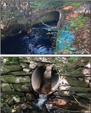
Photographs showing A, Pearl Hill Brook at Mill Creek Drive in Ashby, Massachusetts, on October 1, 2021, where the drop at the outflow of the culvert may impede aquatic organism passage, and B, an unnamed tributary to Trapfall Brook at Harris Road in Ashby, Massachusetts, on October 1, 2021, where the shallow water in the culvert (and the drop at the outflow) may impede aquatic organism passage. Photographs by Brian Nelson, U.S. Geological Survey.
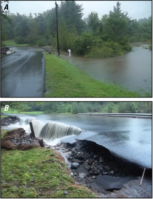
Photographs showing Clesson Brook flooding the culvert and road on Pond Road in Hawley, Massachusetts, on August 28, 2011. A, The flooded culvert and road about 200 feet away. B, The flooded culvert and roadway demonstrate that the undersized culvert did not allow this flood flow to pass through the structure. Photographs by the University of Massachusetts Amherst, River Smart Communities, used with permission.
The U.S. Geological Survey (USGS), Massachusetts Department of Environmental Protection (MassDEP), and University of Massachusetts Amherst (UMass Amherst) began a series of cooperative studies in July 2019 to develop an automated geographic information system (GIS) hydraulic modeling tool for preliminary culvert designs for stream crossings. The USGS plans to provide preliminary culvert designs in the web-based StreamStats application, which enables municipalities and engineers to view potential designs and related information for stream crossing replacement projects in Massachusetts. This application can (a) provide information on hydrology, hydraulics, and ecological conditions at stream crossing sites, (b) provide users with potential culvert designs to improve aquatic organism passage and flood resiliency, and (c) assist MassDEP in implementing the Massachusetts Wetlands Protection Act regulations for stream crossing projects (MassDEP, 2017).
Massachusetts Stream Crossing Standards
In 2000, UMass Amherst started evaluating stream crossings to promote aquatic organism passage in culvert designs. This stream continuity project (UMass Amherst, 2015) and related work led to a draft of the Massachusetts stream crossing standards in 2004 (previously referred to as the “Massachusetts river and stream crossing standards”; River and Stream Continuity Partnership, 2006). The draft stream crossing standards were incorporated into the U.S. Army Corps of Engineers' general permits for Massachusetts in 2005. In 2012, the Massachusetts Department of Fish and Game, Division of Ecological Restoration, published the Massachusetts Stream Crossing Handbook, which describes six stream crossing standards for a well-designed stream crossing (fig. 3; Massachusetts Division of Ecological Restoration, 2012):
-
• Type of crossing: bridges, three-sided box culverts, or arch culverts with open bottoms
-
• Embedment: culverts with a closed bottom should be embedded into the streambed a minimum of 2 feet or 25 percent of the culvert height or diameter, whichever is greater.
-
• Span (width): culvert spans should be 1.2 times the stream channel’s bankfull width.
-
• Openness ratio: culvert openness ratio (culvert cross-sectional area divided by culvert length) should be greater than or equal to 0.82 to ensure that the culvert is wide and high relative to its length.
-
• Substrate: culvert bottoms should be natural and match the upstream and downstream substrate.
-
• Water depth and velocity: water depths and velocities at the culvert are comparable to those in the natural upstream and downstream channels.
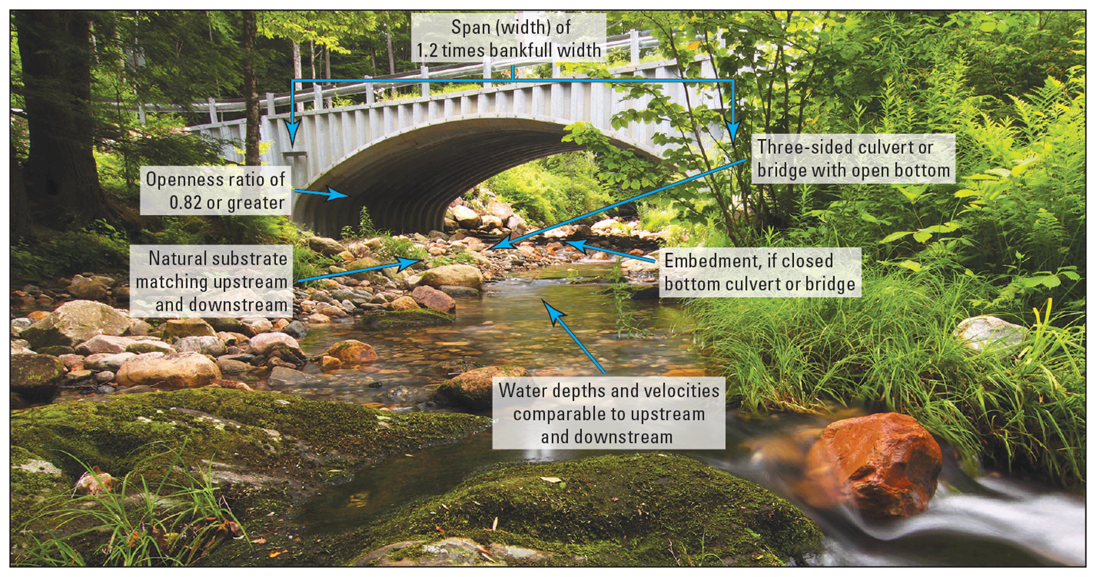
Schematic of a well-designed stream crossing that meets the six Massachusetts stream crossing standards (Massachusetts Division of Ecological Restoration, 2012). Photograph by Paul Nguyen, used with permission.
In 2014, MassDEP incorporated the stream crossing standards into 310 CMR 10.00—the Wetlands Protection Act regulations (MassDEP, 2017)—which specifies that replacement stream crossings must be designed to meet the stream crossing standards to the maximum extent practicable (sections 310 CMR 10.24(10) and 10.53(8)). The regulations state that a proposed stream crossing shall demonstrate that negative effects of the crossing have been prevented or minimized and mitigated. The regulations also state that projects must evaluate the potential to comply with the standards to the maximum extent practicable by considering site constraints, undesirable effects or risk, and the environmental benefit compared with the cost.
In early 2010s, the USGS, in cooperation with MassDEP, completed a study that developed hydraulic models for seven stream crossings across Massachusetts (Zarriello and Barbaro, 2014). These hydraulic models were used to evaluate the existing culverts and to develop culvert replacement designs that meet the stream crossing standards and allow aquatic organism passage. The study indicated that the existing culverts did not meet the stream crossing standards and could not convey modeled flood flows, resulting in road deck overtopping and upstream backwater. Culvert replacement designs that met the stream crossing standards were mostly able to convey the modeled flood flows without causing upstream backwater.
In 2017, the Massachusetts Department of Fish and Game, Division of Ecological Restoration, started a Culvert Replacement Municipal Assistance Grant Program for communities in the State wishing to replace aging culverts. The grant program provides funding for culvert designs that improve structural and environmental designs, improve flood resiliency, and meet the stream crossing standards (Massachusetts Division of Ecological Restoration, 2022). Preliminary culvert designs produced by the USGS StreamStats automated GIS-based hydraulic modeling tool are designed to align with the grant program’s goals.
The North Atlantic Aquatic Connectivity Collaborative (NAACC; UMass Amherst, 2022) has continued stream crossing assessments for aquatic organism passage across Massachusetts that were started by UMass Amherst in 2000. These stream crossing assessments for many culverts and small bridges in Massachusetts and other northeastern States are available at https://naacc.org/naacc_search_crossing.cfm. Stream crossing codes for the NAACC stream crossing assessments are provided in USGS StreamStats so the user can search the NAACC for the assessment data of existing stream crossings.
An Automated GIS-Based Hydraulic Modeling Tool
The USGS has developed an automated GIS-based hydraulic modeling tool using ArcGIS software, the Python programming language, and the U.S. Army Corps of Engineers Hydrologic Engineering Center’s River Analysis System (HEC–RAS; U.S. Army Corps of Engineers, 2021). The tool is used to develop preliminary designs for box, arch, and pipe culverts to convey the 10-, 4-, 2-, and 1-percent annual exceedance probability (AEP) flood flows (equivalent to the 10-, 25-, 50-, and 100-year recurrence interval flood flows) and to meet the Massachusetts stream crossing standards. The flood flows used in the tool are adopted from hydraulic design flows associated with the roadway functional classification used by the Massachusetts Department of Transportation (MassDOT, 2025a, b) for culverts and bridges. The goals of these preliminary designs are to ensure that undersized stream crossing replacements are not in-kind (the same design as the original) and that the designs provide some flood resilience and aquatic organism passage. The range of preliminary designs provides possible options based on the habitat quality and stream connectivity restoration potential at the stream crossing while also meeting the stream crossing standards to the maximum extent practicable (fig. 4).
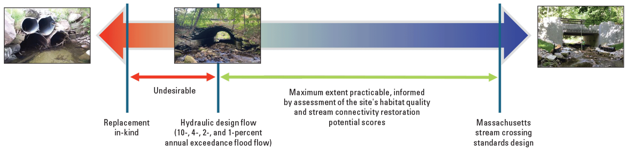
Conceptual diagram for evaluation of stream crossing replacement designs. Replacement in-kind refers to replacement culverts that are the same size as the culvert removed. The hydraulic design flows are indicated as the recommended minimum hydrology and hydraulic standards. Stream crossings with higher habitat quality and stream connectivity restoration potential scores (towards the right) may be expected to more closely meet the Massachusetts stream crossing standards. Modified from diagram by Scott Jackson (University of Massachusetts Amherst, written commun., 2022).
The automated tool derives hydrologic and hydraulic data needed for HEC–RAS models. The hydrology for the 10-, 4-, 2-, and 1-percent AEP flood flows needed for the models is estimated by using the Massachusetts flood flow equations by Zarriello (2017). The hydraulic data needed for input to HEC–RAS include the approach, upstream and downstream face (inlet and outlet) of the culvert, and exit cross sections. The tool creates these cross sections using high-resolution elevation data from the lidar-derived digital elevation models, and stream channel bathymetry is estimated by using the Massachusetts bankfull channel geometry equations (Bent and Waite, 2013).
The automated tool runs the HEC–RAS program starting with minimum predetermined spans of the estimated bankfull width at the roadway stream-crossing site for the 10-, 4-, 2-, and 1-percent AEP flood flows to keep flow velocities in the culvert similar to upstream velocities away from the influence of the culvert. The tool increases the size of the culvert, as needed to convey the estimated flood flows, on the basis of standard precast concrete culvert sizes for box and pipe culverts used in the HEC–RAS program. The final culvert designs are set to have at least 1.0 or 2.0 feet of freeboard—the distance from the water surface to the low chord (top) of the culvert—to comply with chapter 85, section 35 of the Massachusetts General Laws’ (Commonwealth of Massachusetts, 2025) review process for municipal bridge projects. The stream-crossing standard design is set to meet two standards: a span of 1.2 times the stream channel’s bankfull width and the openness ratio equal to or greater than 0.82.
USGS StreamStats Web Application
Currently (2026), the USGS is implementing the automated GIS tool for making preliminary culvert designs for roadway stream crossings in Massachusetts in the StreamStats web application (https://streamstats.usgs.gov/ss/). USGS StreamStats is a map-based web application that provides an assortment of analytical tools that can be used for water-resources planning and management and for engineering purposes (Ries and others, 2017, 2024).
In StreamStats, the user can open a stream crossing site’s culvert replacement report to view general site information, which includes the following:
-
• Delineated drainage area
-
• Location (latitude, longitude, stream name, road name, and town or city)
-
• General North Atlantic Aquatic Connectivity Collaborative (NAACC) stream assessment information, including a link (crossing code) to the stream assessment (UMass Amherst, 2022)
-
• Basin characteristics used to solve the Massachusetts AEP flood flows and bankfull channel geometry equations
-
• Habitat quality score, based on five factors (Scott Jackson, UMass Amherst, written commun., 2022):
-
▪ BioMap: the future of conservation in Massachusetts (Massachusetts Division of Fisheries and Wildlife and The Nature Conservancy, 2025)
-
▪ Cold-water fisheries resource (Massachusetts Division of Fisheries and Wildlife, 2025)
-
▪ Area of critical environmental concern (Massachusetts Department of Conservation and Recreation, 2025)
-
▪ Wild and scenic river (National Wild and Scenic Rivers System, 2025)
-
▪ Diadromous fish runs (Massachusetts Bureau of Geographic Information, 2025)
-
-
• Stream connectivity restoration potential score, based on two UMass Amherst conservation assessment and prioritization system factors (Scott Jackson, UMass Amherst, written commun., 2022):
-
▪ Critical linkages (UMass Amherst, 2025)
-
▪ Cold-water critical linkages (UMass Amherst, 2025)
-
-
• Roadway functional classification (MassDOT, 2025a)
-
• Hydraulic design flow (MassDOT, 2025b)
-
• AEP flood flows (Zarriello, 2017)
-
• Bankfull channel geometry (Bent and Waite, 2013)
The habitat quality and stream connectivity information are used to provide scores of the aquatic and biological importance of stream crossings. MassDEP and UMass Amherst are currently (2026) developing a guidance document on how these scores could be used to help determine the final culvert design.
The user can then view the GIS-based hydraulic modeling tool output (fig. 5), which includes dimensions, length, cross-sectional area, selected elevations, and stream crossing standards values of the preliminary culvert designs for three-sided box, three-sided arch, and pipe culverts.
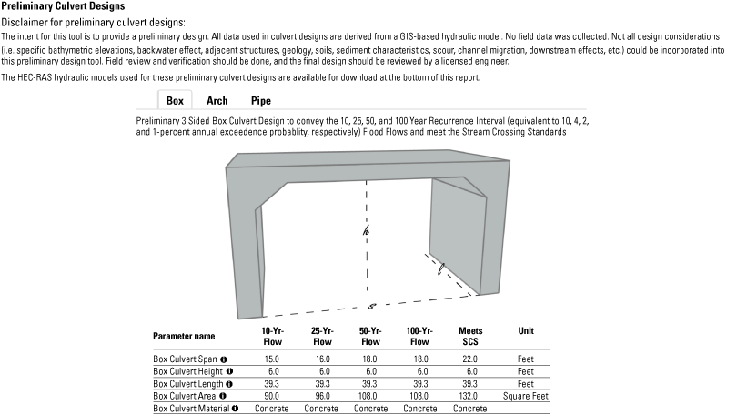
Example of preliminary culvert designs for a stream crossing in U.S. Geological Survey StreamStats produced by the automated geographic information system-based hydraulic modeling tool developed for Massachusetts.
Preliminary culvert designs convey the 10-, 4-, 2-, and 1-percent AEP flood flows and meet the Massachusetts stream crossing standards. The user can compare preliminary designs, assess the habitat quality and stream connectivity scores, and then select the preliminary design(s) that will best assist their community in improving flood resiliency and aquatic organism passage for its stream crossing project. The user can also download the input and output files for the HEC–RAS hydraulic model from StreamStats.
Acknowledgments
The authors thank Lisa Rhodes, David Hilgeman (former employee), Christina Wu, Tom Maguire, and Rebecca Davis of the Massachusetts Department of Environmental Protection for continued technical input and review of this study; and Scott A. Jackson of the University of Massachusetts Amherst for providing technical input.
Selected References
Bent, G.C., and Waite, A.M., 2013, Equations for estimating bankfull channel geometry and discharge for streams in Massachusetts: U.S. Geological Survey Scientific Investigations Report 2013–5155, 62 p., accessed August 5, 2021, at https://doi.org/10.3133/sir20135155.
Bent, G.C., Trickey, K.V., and Jackson, S.D., 2022, Developing a statewide hydraulic modeling tool—A feasibility study for Massachusetts: U.S. Geological Survey web page, assessed March 10, 2023, at https://newengland.water.usgs.gov/web_app/Stream_Crossing/index.html.
Bent, G., Sturtevant, L., McCarthy, B., Armstrong, I., McCallister, M., Poe, M., Graziano, A., Tudor, A., and Carlson, C., 2025, An automated hydraulic modeling tool for road stream-crossing replacement projects in Massachusetts: ASSHTO Technical Committee on Hydrology and Hydraulics, Hydrolink newsletter, no. 26, p. 9–12, accessed December 3, 2025, at https://transportation.org/design/technical-committees/hydrology-and-hydraulics/.
Commonwealth of Massachusetts, 2025, Municipal bridge projects—Massachusetts General Laws chapter 85 section 35 review process—Design requirements and submittals for new bridge and full bridge replacement projects: Massachusetts Department of Transportation table, 3 p., accessed December 3, 2025, at https://www.mass.gov/doc/new-bridge-and-bridge-replacement-project-requirements/download.
Massachusetts Bureau of Geographic Information, 2025, MassGIS data—Diadromous fish: Commonwealth of Massachusetts website, accessed March 3, 2025, at https://www.mass.gov/info-details/massgis-data-diadromous-fish.
Massachusetts Culverts and Small Bridges Working Group, 2020, Recommendations for improving the efficiency of culvert and small bridge replacement projects: Prepared for Senator Hinds and the Massachusetts Legislature, 69 p., accessed August 1, 2021, at https://www.mass.gov/doc/massachusetts-culverts-and-small-bridges-working-group-report/download.
Massachusetts Department of Conservation and Recreation, 2025, ACEC program overview: Commonwealth of Massachusetts website, accessed February 24, 2025, at https://www.mass.gov/info-details/acec-program-overview.
Massachusetts Department of Environmental Protection [MassDEP], 2017, Wetlands protection, section 10 of Department of Environmental Protections: Code of Massachusetts Regulations, title 310, accessed April 22, 2022, at https://www.mass.gov/doc/310-cmr-1000-the-wetlands-protection-act.
Massachusetts Department of Environmental Protection [MassDEP], 2019, Stream crossing standards: Massachusetts Department of Environmental Protection video, posted January 16, 2019, accessed September 1, 2022, at https://www.youtube.com/watch?v=U3O0nXxKLvg.
Massachusetts Department of Transportation [MassDOT], 2025a, Road Inventory 2024: Massachusetts Department of Transportation dataset, accessed September 20, 2025, at https://geo-massdot.opendata.arcgis.com/datasets/MassDOT:road-inventory-2024/about.
Massachusetts Department of Transportation [MassDOT], 2025b Bridge manual—Part I—Hundredth anniversary edition (rev. January 2025): Massachusetts Department of Transportation, Highway Division, [variously paged; 72 p.], accessed October 1, 2025, at https://massdot.docs.mass.gov/hwy-bridge-manual/part-1/ch2-prelim-engineering-guidelines-w-appendix_0125.pdf.
Massachusetts Division of Ecological Restoration, 2012, Massachusetts stream crossing handbook (2d ed.): Massachusetts Department of Fish and Game, 13 p., accessed August 1, 2021, at https://www.mass.gov/doc/massachusetts-stream-crossing-handbook/download.
Massachusetts Division of Ecological Restoration, 2022, Culvert replacement municipal assistance grant program: Commonwealth of Massachusetts website, accessed April 28, 2022, at https://www.mass.gov/how-to/culvert-replacement-municipal-assistance-grant-program.
Massachusetts Division of Fisheries and Wildlife, 2025, Coldwater fish resources: Commonwealth of Massachusetts website, accessed August 8, 2025, at https://www.mass.gov/info-details/coldwater-fish-resources.
Massachusetts Division of Fisheries and Wildlife and The Nature Conservancy, 2025, BioMap—The future of conservation in Massachusetts: Massachusetts Division of Fisheries and Wildlife and The Nature Conservancy website, accessed July 28, 2025, at https://biomap-mass-eoeea.hub.arcgis.com/.
National Wild and Scenic Rivers System, 2025, Massachusetts: National Wild and Scenic Rivers System website, accessed August 8, 2025, at https://www.rivers.gov/massachusetts.
Ries, K.G., III, Newson, J.K., Smith, M.J., Guthrie, J.D., Steeves, P.A., Haluska, T.L., Kolb, K.R., Thompson, R.F., Santoro, R.D., and Vraga, H.W., 2017, StreamStats, version 4: U.S. Geological Survey Fact Sheet 2017–3046, 4 p., accessed August 8, 2021, at https://doi.org/10.3133/fs20173046.
Ries, K.G., III, Steeves, P.A., and McCarthy, P., 2024, StreamStats—A quarter century of delivering web-based geospatial and hydrologic information to the public, and lessons learned: U.S. Geological Survey Circular 1514, 40 p. [Also available at https://doi.org/10.3133/cir1514.]
River and Stream Continuity Partnership, 2006, Massachusetts river and stream crossing standards, revised March 1, 2011: University of Massachusetts Amherst, The Nature Conservancy, Massachusetts Division of Ecological Restoration-Riverways Program, and American Rivers, 27 p., accessed May 23, 2025, at https://www.mass.gov/doc/massachusetts-river-and-stream-crossing-standards/download.
Sturtevant, L.P., and McCarthy, B.A., 2024, Massachusetts stream crossing project data web map service: U.S. Geological Survey data release, https://doi.org/10.5066/P9BL9CW4.
Taylor, N.J., Sturtevant, L.P., and McCarthy, B.A., 2024, Hydraulic models and supplementary data for selected stream crossing sites in the Squannacook River basin, north-central Massachusetts (ver. 1.1, July 2024): U.S. Geological Survey data release, accessed July 28, 2024, at https://doi.org/10.5066/P9IUR97R.
U.S. Army Corps of Engineers, 2021, HEC–RAS: U.S. Army Corps of Engineers Hydrologic Engineering Center web page, accessed August 4, 2021, at https://www.hec.usace.army.mil/software/hec-ras/.
U.S. Geological Survey [USGS], 2021, StreamStats—Streamflow statistics and spatial analysis tools for water-resources applications: U.S. Geological Survey web page, accessed July 30, 2021, at https://www.usgs.gov/mission-areas/water-resources/science/streamstats-streamflow-statistics-and-spatial-analysis-tools?qt-science_center_objects=0#qt -science_center_objects.
U.S. Geological Survey [USGS], 2025, Stream crossings—Massachusetts hydraulic modeling tool: U.S. Geological Survey video, 00:08:25, posted July 30, 2024, accessed August 31, 2025, at https://www.usgs.gov/media/videos/introducing-massachusetts-statewide-hydraulic-modeling-tool.
University of Massachusetts Amherst [UMass Amherst], 2015, Assessing stream crossings and culverts in 13 states: University of Massachusetts Amherst, Center for Agriculture, Food, and the Environment web page, accessed October 28, 2021, at https://ag.umass.edu/news-events/highlights/assessing-stream-crossings-culverts-in-13-states.
University of Massachusetts Amherst [UMass Amherst], 2022, The stream continuity portal: University of Massachusetts Amherst Center for Agriculture, Food, and the Environment web page, accessed May 8, 2022, at https://streamcontinuity.org/.
University of Massachusetts Amherst [UMass Amherst], 2025, Conservation assessment and prioritization system: University of Massachusetts Amherst Center for Agriculture, Food, and the Environment web page, accessed May 23, 2025, at http://www.umasscaps.org/applications/critical-linkages.html.
Zarriello, P.J., and Barbaro, J.R., 2014, Hydraulic assessment of existing and alternative stream crossings providing fish and wildlife passage at seven sites in Massachusetts: U.S. Geological Survey Scientific Investigations Report 2014–5146, 36 p., accessed July 31, 2021, at https://doi.org/10.3133/sir20145146.
Zarriello, P.J., 2017, Magnitude of flood flows at selected annual exceedance probabilities for streams in Massachusetts: U.S. Geological Survey Scientific Investigations Report 2016–5156, 54 p., accessed July 31, 2025, at https://doi.org/10.3133/sir20165156.
For more information, contact:
Director, New England Water Science Center
dc_nweng@usgs.gov
or visit our website at
https://www.usgs.gov/centers/new-england-water
Project website: https://www.usgs.gov/centers/new-england-water-science-center/science/a-statewide-hydraulic-modeling-tool-stream
Disclaimers
Any use of trade, firm, or product names is for descriptive purposes only and does not imply endorsement by the U.S. Government.
Although this information product, for the most part, is in the public domain, it also may contain copyrighted materials as noted in the text. Permission to reproduce copyrighted items must be secured from the copyright owner.
Suggested Citation
Bent, G.C., McCarthy, B.A., Sturtevant, L.P., McCallister, M.A., Tudor, A.L., Armstrong, I.P., Poe, M.W., Graziano, A.P., and Carlson, C.S., 2026, An automated geographic information system-based hydraulic modeling tool for developing preliminary culvert designs for stream crossings in Massachusetts: U.S. Geological Survey Fact Sheet 2026–3065, 6 p., https://doi.org/10.3133/fs20263065.
ISSN: 2327-6932 (online)
ISSN: 2327-6916 (print)
Study Area
| Publication type | Report |
|---|---|
| Publication Subtype | USGS Numbered Series |
| Title | An automated geographic information system-based hydraulic modeling tool for developing preliminary culvert designs for stream crossings in Massachusetts |
| Series title | Fact Sheet |
| Series number | 2026-3065 |
| DOI | 10.3133/fs20263065 |
| Publication Date | May 01, 2026 |
| Year Published | 2026 |
| Language | English |
| Publisher | U.S. Geological Survey |
| Publisher location | Reston, VA |
| Contributing office(s) | New England Water Science Center |
| Description | 6 p. |
| Country | United States |
| State | Massachusetts |
| Online Only (Y/N) | N |
| Additional Online Files (Y/N) | N |