

Annotated Bibliography of Scientific Research on Greater Sage-Grouse Published from October 2019 to July 2022
Links
- Document: Report (5.86 MB pdf) , HTML , XML
- Version History: Version History (12.0 kB txt)
- Download citation as: RIS | Dublin Core
Acknowledgments
Funding for this work was provided by the Bureau of Land Management (BLM). We are appreciative of the input and guidance of Travis Haby (BLM National Operations Center), Patricia Deibert (BLM Division of Wildlife, Aquatics, and Environmental Protection), Megan McLachlan (BLM National Operations Center), Leah Waldner (BLM Colorado State Office), and Lief Wiechman (U.S. Geological Survey [USGS] Land Management Research Program). We are grateful to Dawn Davis (U.S. Fish and Wildlife Service [FWS]), David Haukos (USGS Kansas Cooperative Fish and Wildlife Research Unit), Vicki Herren (BLM), Jenny Hill (FWS), Daniel Manier (USGS), Andrew Olsen (Intermountain West Joint Venture), Mark Ricca (USGS), and Nicholas Van Lanen (USGS) for providing independent peer review of the report and the summaries it contains. We thank the many authors of publications summarized within this annotated bibliography for providing input on the draft product summaries, including David Aadland (University of Wyoming), Cameron Aldridge (USGS), Skip Ambrose (Western Bioacustics, Inc.), Christopher Anthony (USGS), Andy Baltensperger (University of Alaska Fairbanks), Trevor Bloom (The Nature Conservancy), Ken Boykin (New Mexico State University), John Bradford (USGS), Jacob Burdick (University of Nevada, Reno), Brian Cade (USGS), Anna Chalfoun (USGS Wyoming Cooperative Fish and Wildlife Research Unit), Sarah Carter (USGS), Melissa Chelak (Utah State University), Peter Coates (USGS), Micheal Curran (University of Wyoming), Kevin Doherty (FWS), Richard Dolbeer (U.S. Department of Agriculture), Sergei Drovetski (Smithsonian Institution), Courtney Duchardt (Oklahoma State University), Katie Dugger (Oregon State University), Kasten Dumroese (U.S. Department of Agriculture), James Dwyer (EDM International, Inc.), Brad Fedy (University of Waterloo), Marcella Fremgen-Taratino (Boise State University), Erin Gelling (University of Wyoming), Michael Gerringer (Western EcoSystems Technology, Inc.), Hayes Goosey (Montana State University), Seth Harju (Heron Ecological), Julie Heinrichs (Colorado State University), Jacob Hennig (Oklahoma State University), Angela Hild (University of Wyoming), Sarah Horsley (University of Georgia), Tracey Johnson (University of Idaho), Kevin Kohl (University of Pittsburgh), Christopher Kirol (University of Waterloo), Melanie Kunkel (University of Georgia), John Lloyd (Renewable Energy Wildlife Institute), Kyle Larson (Pacific Northwest National Laboratory), Marc Meyer (U.S. Department of Agriculture), Adrian Monroe (USGS), David Naugle (University of Montana), Michael O’Donnell (USGS), Peter Olsoy (Washington State University), Kyle Palmquist (Marshall University), Lindsey Parsons (South Dakota State University), Neal Pastick (USGS), David Pilliod (USGS), Sharon Poessel (USGS), Brian Prochazka (USGS), Louis Provencher (The Nature Conservancy), David Pyke (USGS), Jordan Rabon (University of Idaho), Kenny Randall (University of Idaho), Dana Reiter (University of British Columbia), Corinna Riginos (The Nature Conservancy), Frank Rivera-Milán (FWS), Phillip Rose (Alberta Conservation Association), Jessica Shyvers (The Nature Conservancy), Brenda Smith (High Desert Partnership), Joseph Smith (University of Montana), Nelson Stauffer (U.S. Department of Agriculture), David Stoner (Utah State University), Emma Vaasjo (Calgary Zoo), Brett Walker (Colorado Parks and Wildlife), Gregory Wann (USGS), Jessica Wright (U.S. Department of Agriculture), and Cindy Yu (Iowa State University).
Abstract
Integrating recent scientific knowledge into management decisions supports effective natural resource management and can lead to better resource outcomes. However, finding and accessing scientific knowledge can be time consuming and costly. To assist in this process, the U.S. Geological Survey (USGS) created a series of annotated bibliographies on topics of management concern for western lands. Previously published reports introduced a methodology for preparing annotated bibliographies to facilitate integration of recent, peer-reviewed science into resource management decisions. Therefore, relevant text from those efforts is reproduced here and built on to incorporate new information. The greater sage-grouse (Centrocercus urophasianus; hereafter “GRSG”) has been a focus of scientific investigation and management action for the past two decades. The 2015 U.S. Fish and Wildlife Service listing determination of “not warranted” under the Endangered Species Act was in part a result of a large-scale collaborative effort to develop strategies to conserve GRSG populations and their habitat and to reduce threats to both. New scientific information augments existing knowledge and can help inform updates or modifications to existing plans for managing GRSG and sagebrush ecosystems. However, the sheer number of scientific publications can be a challenge for managers tasked with evaluating and determining the need for potential updates to existing planning documents. To assist in this process, the USGS has reviewed and summarized the scientific literature published since January 1, 2015. Our most recent GRSG literature summary was published in 2020 (Carter and others, 2020) and included products published through October 2, 2019. Here, we consider products published between October 2, 2019, and July 21, 2022. We compiled and summarized peer-reviewed journal articles, data products, and formal technical reports (such as U.S. Department of Agriculture Forest Service General Technical Reports and USGS Open-File Reports) on greater sage-grouse. We first systematically searched three reference databases and three government databases using the search phrase “greater sage-grouse.” We refined the initial list of products by removing (1) duplicates, (2) publications not published as research, data products, or scientific review articles in peer-reviewed journals or as formal technical reports, and (3) products for which greater sage-grouse was not a research focus or the study did not present new data or findings about greater sage-grouse. We summarized each product using a consistent structure (background, objectives, methods, location, findings, and implications) and identified management topics addressed by each product; for example, species and population characteristics. We also identified projects that provided new geospatial data. The review process for this annotated bibliography included two initial internal colleague reviews of each summary, requesting input on each summary from an author of the original publication, and formal peer review. Our initial searches resulted in 221 total products, of which 147 met our criteria for inclusion. Across products summarized in the annotated bibliography, broad-scale habitat characteristics, behavior or demographics, site-scale habitat characteristics, habitat selection, and population estimates or targets were the most commonly addressed management topics. The online version of this bibliography, which will be available on the Science for Resource Managers tool (https://apps.usgs.gov/science-for-resource-managers), will be searchable by topic, location, and year, and will include links to each original publication. The studies compiled and summarized here may inform planning and management actions that seek to maintain and restore sagebrush landscapes and GRSG populations across the GRSG range.
Introduction
Reviewing best available science relevant to land management decisions and resource planning efforts is important for providing content and context for making decisions, helping to ensure proposed resource management actions and decisions are as effective as possible in meeting management agencies’ stated goals. However, the number of scientific publications, restrictive access to many publications and publication databases, and time needed to perform a comprehensive search for best available science on any given species or topic can hinder resource managers’ ability to access and consider this science in their decisions. To facilitate the integration of science into decision making on western lands, the U.S. Geological Survey (USGS) initiated a program of work to compile and summarize recent, peer-reviewed scientific literature on a series of resources and topics of management concern.
The greater sage-grouse (Centrocercus urophasianus; hereafter GRSG) has been a focus of scientific investigation and management action for the past two decades, as the U.S. Fish and Wildlife Service (FWS) has reviewed a series of petitions to list the species under the Endangered Species Act of 1973. Listing petitions were filed after documentation of long-term declines in GRSG population numbers and distribution (Schroeder and others, 2004; Knick and Connelly, 2011; Western Association of Fish and Wildlife Agencies, 2015). These declines are primarily attributed to the loss and degradation of sagebrush landscapes from threats including fire, invasive species, and human activity (Connelly and others, 2000; Schroeder and others, 2004; Knick and Connelly, 2011; U.S. Fish and Wildlife Service, 2013).
Public, private, and interagency collaboration to conserve GRSG populations and their habitat and reduce threats contributed substantially to the most recent FWS listing determination of “not warranted” (U.S. Department of the Interior, 2015). The Bureau of Land Management (BLM) manages 67 million acres of GRSG habitat in 11 States across the species’ range and is in the process of amending land-use plans to consider developments in recent science, address GRSG habitat loss and population declines, and respond to effects from climate change across the sagebrush biome (Bureau of Land Management, 2022). The large body of scientific literature on GRSG and their response to habitat conditions and threats informed the 2015 listing determination and efforts to amend BLM land-use plans. However, many uncertainties remain in our understanding of how GRSG respond to changes in their environment, and the scientific community has continued to conduct new studies to strengthen the science foundation for GRSG management and conservation.
New scientific information augments existing knowledge and can help inform updates or modifications to existing plans for managing GRSG and their habitats and strategies for alleviating threats to both. However, the sheer number of scientific publications developed through time can pose a daunting challenge for managers tasked with evaluating and determining the need for potential updates to existing plans and decisions. To assist this process, the USGS reviewed and summarized scientific literature published between 2015 and 2019. Our most recent GRSG literature summary was published in 2020 (Carter and others, 2020). Here, we provide an updated annotated bibliography including summaries of products published between October 2, 2019 and July 21, 2022.
Although this annotated bibliography does not replace the need to read the primary literature and published products, the goal is to provide an accessible, plain-language reference for planners and managers responsible for managing GRSG populations and habitat. Each product summary (and associated publication) will be available on the Science for Resource Managers tool (https://apps.usgs.gov/science-for-resource-managers) and will be searchable by management topic, location, year, and keywords. Any search conducted on the Science for Resource Managers tool can be downloaded as a formatted report that provides a summary of details on the search criteria used and a list of all the summaries from a given search. We also provide links to the original publications to facilitate access to primary literature sources. As such, information in this document could be maintained and periodically updated to serve as a readily accessible, up-to-date resource for managers, planners, academics, and policymakers who need a quick reference to recent peer-reviewed science and data about GRSG.
Methods
Previous reports (Carter and others, 2020) introduced a methodology for conducting annotated bibliographies to facilitate the integration of recent, peer-reviewed science into resource management decisions. This and other annotated bibliographies (for example, Poor and others, 2021; Kleist and others, 2022) build on that method by applying it to new species and topics of management concern on western lands. Therefore, relevant text from these reports is reproduced herein.
We conducted a systematic search of two citation indices (Web of Science and Scopus [accessed through the USGS Library]), and three Federal Government publication databases (USGS ScienceBase, USGS Publications Warehouse, and U.S. Department of Agriculture Forest Service TreeSearch), using the search phrase “greater sage-grouse.” We developed this search phrase through consultation with GRSG experts to help ensure our searches would capture products relevant to management of GRSG on western lands in the United States. We conducted our final standard search of all databases on July 21, 2022. However, we opportunistically included products brought to our attention through other means until August 1, 2023 (for example, products shared with us as part of our process of requesting feedback from the original product author on summaries). Because databases were not formally searched after July 21, 2022, any literature published after this search was included in this bibliography opportunistically and represents an incomplete list of relevant literature published after July 21, 2022.
We refined the initial list of all products in five ways. First, we removed duplicate items. Second, we retained only those articles with the phrase “greater sage-grouse” present in the article title, abstract, or author-supplied keywords (when available) and in the main text of the article to ensure the article addressed GRSG. Third, we excluded products not focused within North America. Fourth, we excluded products not published as research or scientific review articles in peer-reviewed journals or as formal technical reports; this exclusion helped ensure that all products presented final peer-reviewed work. Accordingly, we excluded editorial content (such as policy perspectives and commentaries), reports without evidence of a formal peer-review process (such as project and annual reports without a technical series or volume number and a permanent digital object identifier), conference abstracts, article preprints, articles in magazines (lacking reference to a peer-review process), articles in journals lacking evidence of a comprehensive peer-review process, theses, dissertations, manuscripts not yet in press, and books, regardless of peer-review status. We also excluded products that provided short summaries of research projects (often published when those projects were still in progress) that were intended for sharing with a broad public audience, as those research results would be published elsewhere once these studies were complete. Fifth, we excluded any remaining products that, upon review, did not have clear relevance to conservation and management of GRSG. For example, we excluded research articles primarily about another species with GRSG mentioned only for context or comparison, often in the introduction or discussion sections. We also excluded publications that focused on or within GRSG habitat but did not present new findings about GRSG ecology. For very large publications (for example, hundreds of pages) covering multiple topics and species, we explicitly confined our summaries to GRSG and stated this in the summary itself. We cannot guarantee our search process identified all products, particularly for journals that did not have keywords or for which keywords were not indexed by Web of Science or Scopus. However, we made every effort to identify these articles through Google Scholar.
Google Scholar indexes a wider range of products than the other search engines and thus required slightly different methods. Many of the Google Scholar search results were not published products, were not written in English, or did not focus on systems in North America. Thus, for the Google Scholar search, we used R (R Core Team, 2020) to iteratively filter search results based on metadata provided by Google Scholar. We first removed products of type “citation” and then used identifiers in the uniform resource locator (URL) to remove products that were books, book chapters, patents, theses, or dissertations. We subsetted products that included text in the abstract or title identified as a language other than English by either of two methods of language detection (Ooms, 2018, 2020). To ensure accurate results, we screened abstracts and titles of subsetted non-English products (Westgate, 2019) and reintegrated those that could not be reliably excluded by language recognition. We then excluded products with URLs that did not have a domain of .com, .edu, .org, .us, .gov, .net, .ca, .uk, .mil, .au, or .info. Finally, we removed articles from any journals that did not meet our peer review standards. We manually filtered remaining articles so that our final list of products included in the annotated bibliography met all criteria described herein.
We divided the final list of articles and reports among our group of scientists to develop summaries of each product. A scientist read each publication, summarized its contents using a consistent structure (background, objectives, methods, location, findings, and implications), and identified the management topics addressed (table 1). We included location information such as the State(s) and (or) province(s) where the study took place, depending on the information provided in the article. After geographic location, we listed climate cluster(s) (fig. 1; designated in Coates and others, 2021; hereafter CC) and management zone(s) (fig. 2; from U.S. Fish and Wildlife Service 2014a, b; hereafter MZ) where possible. In some articles or reports, however, specific location information was not made clear, and we labeled locations as “not specified.” We used scientific names that were used by the authors in the original products; however, we used common names for all species within product summaries for ease of reading. If we had questions about scientific or common names, we checked with the Integrated Taxonomic Information System (https://doi.org/10.5066/F7KH0KBK).
Table 1.
Management categories and topics assessed for each product included in the annotated bibliography.[Table is modified from Maxwell and others (2023)]
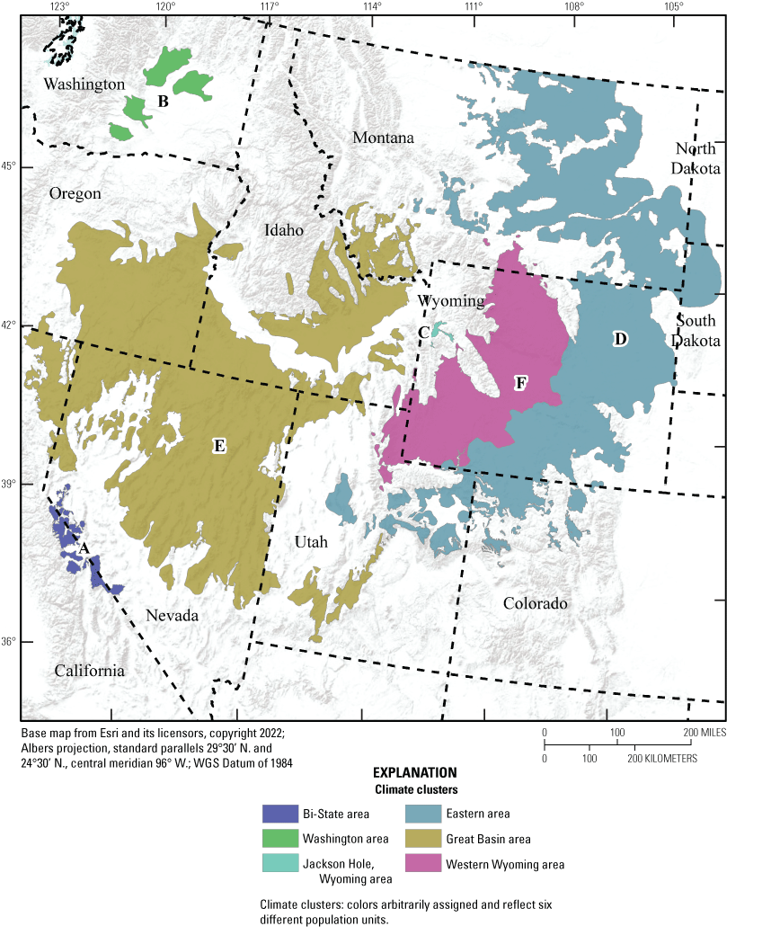
Greater sage-grouse (Centrocercus urophasianus) hierarchical population monitoring framework for climate clusters in the western United States. A, Bi-State area; B, Washington area; C, Jackson Hole, Wyoming, area; D, eastern area; E, Great Basin area; F, western Wyoming area (from Maxwell and others, 2023; modified from Coates and others, 2021).
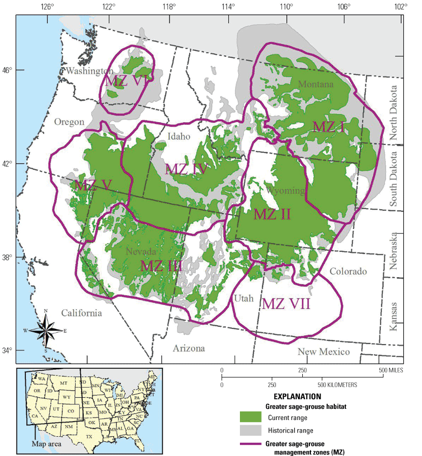
The current and historical distribution of greater sage-grouse (Centrocercus urophasianus) habitat in the western United States and southwestern Canada and the seven management zones (from Maxwell and others, 2023; data from U.S. Fish and Wildlife Service, 2014a, b28; Christiansen and Whitford, 2016).
Considerable information was distilled from each publication in developing the summary. Some products addressed data and findings for several species. In these cases, we focus on the species of interest to this or previous annotated bibliographies or species relevant to the study.
Thus, although we accurately represent information from each publication, there may be additional information in the original product that was not included in our summary. The target length for summaries was 350 words or fewer. Because of the brevity of the summaries in this document, the source documents should always be consulted directly for more specific information (links to the original publication are provided for each summary whenever available). Each draft summary was reviewed by two additional scientists in the group to promote consistency and clarity between summaries and verify that summaries captured key findings from the original publication.
Results and Conclusions
We identified 116 potential products from Web of Science, 18 from Scopus, 8 from USGS Publications Warehouse, 17 from ScienceBase, 6 from U.S. Department of Agriculture Forest Service TreeSearch, and 50 from Google Scholar. We included six additional products that were brought to our attention opportunistically and fit our criteria for inclusion but were not found during our standard search process. After manually removing products that were duplicates, not peer reviewed, and (or) did not present new data or focus on GRSG, we retained a total of 155 peer-reviewed published science and data products from all sources. Eight of these products had previously been summarized in another annotated bibliography (Maxwell and others, 2023). Thus, we ultimately summarized 147 products for this GRSG annotated bibliography.
These 147 products addressed 49 management topics. Every product addressed sensitive/rare wildlife (essentially by definition, because GRSG are considered a species of conservation concern), and 69 products (47 percent) addressed broad-scale habitat characteristics. Sixty-two products (42 percent) addressed behavior or demographics. Fifty-nine products (40 percent) addressed site-scale habitat characteristics. Fifty-four products (37 percent) addressed habitat selection. Fifty-two products (35 percent) addressed population estimates or targets. Reclamation and effect distances or spatial scale were addressed by 38 products (25 percent) each. Between 10 and 25 percent of products addressed energy development, human dimensions or economics, survival, fire, weather and climate patterns, nonnative invasive plants, infrastructure, conifer expansion, dispersal, spread, vectors, and pathways; water; soils or geology; climate change; or grazing/herbivory. Five to ten percent of products addressed the topics of agriculture; protected lands or areas; predators or predator control; translocation; wetlands/riparian; hunting/collectors; wild horses and burros; or public health, safety, or enforcement. Less than 5 percent of products addressed cultural, historical, Native American, or archaeological sites or values; genetics; exurban development; weed management (along with each of the subtopics of cultural control, herbicides, and mechanical vegetation removal); mining; other species and population characteristics; disease, parasite, or microbial; recreation; drought; captive breeding; fuel breaks; fences; forest management/timber harvest; fuels and fuels management; sagebrush removal; or other range management structures. Nineteen products (13 percent) included new geospatial data.
These studies comprise the recent (October 2019 to July 21, 2022) body of published peer-reviewed articles, reports, and data products that focus on GRSG in North America. We present this annotated bibliography as a resource to help land managers more easily access and integrate this information into their decisions. Because GRSG and the sagebrush steppe are of growing conservation concern, this annotated bibliography may be updated periodically to incorporate new knowledge.
Review Process
Critical review of summary content and its correlation with source products was conducted internally by double review within the bibliography team. In addition to our double review, we conducted external reviews consistent with USGS Fundamental Science Practices (Fundamental Science Practices Advisory Committee, 2011). This process was twofold and consisted of (1) requesting input on each product summary from one or more authors of the original peer-reviewed publication and (2) formal peer review of all sections of the document by at least two independent reviewers and by the USGS Bureau Approving Official.
References Cited
Bureau of Land Management, 2022, Potential amendments to land use plans regarding greater sage-grouse conservation scoping report: Bureau of Land Management, [variously paged], accessed January 13, 2018, at https://eplanning.blm.gov/public_projects/2016719/200502020/20062491/250068673/20220627_GRSGScopingReport_Final_508.pdf.
Carter, S.K., Arkle, R.S., Bencin, H.L., Harms, B.R., Manier, D.J., Johnston, A.N., Phillips, S.L., Hanser, S.E., and Bowen, Z.H., 2020, Annotated bibliography of scientific research on greater sage-grouse published from 2015 to 2019: U.S. Geological Survey Open-File Report 2020–1103, 264 p., accessed September 1, 2022, at https://doi.org/10.3133/ofr20201103.
Christiansen, T., and Whitford, N., comp., 2016, GRSG updated historic range with WY “WyomingHistoricRange2014.shp” data: U.S. Geological Survey, ScienceBase, accessed July 21, 2022, at https://www.sciencebase.gov/catalog/item/57e415cce4b090825005b6ac.
Coates, P.S., O’Neil, S.T., Brussee, B.E., Ricca, M.A., Jackson, P.J., Dinkins, J.B., Howe, K.B., Moser, A.M., Foster, L.J., and Delehanty, D.J., 2020, Broad-scale impacts of an invasive native predator on a sensitive native prey species within the shifting avian community of the North American Great Basin: Biological Conservation, v. 243, article 108409, accessed September 19, 2023, at https://doi.org/10.1016/j.biocon.2020.108409.
Coates, P.S., Prochazka, B.G., O’Donnell, M.S., Aldridge, C.L., Edmunds, D.R., Monroe, A.P., Ricca, M.A., Wann, G.T., Hanser, S.E., Wiechman, L.A., and Chenaille, M.P., 2021, Range-wide greater sage-grouse hierarchical monitoring framework—Implications for defining population boundaries, trend estimation, and a targeted annual warning system: U.S. Geological Survey Open-File Report 2020–1154, 243 p., accessed August 22, 2023, at https://doi.org/10.3133/ofr20201154.
Copeland, H.E., Doherty, K.E., Naugle, D.E., Pocewicz, A., and Kiesecker, J.M., 2009, Mapping oil and gas development potential in the US intermountain west and estimating impacts to species: PLoS One, v. 4, no. 10, article e7400, accessed July 22, 2023, at https://doi.org/10.1371/journal.pone.0007400.
Duchardt, C.J., Monroe, A.P., Edmunds, D.R., Holloran, M.J., Holloran, A.G., and Aldridge, C.L., 2023, Using neutral landscape models to evaluate the umbrella species concept in an ecotone: Landscape Ecology, v. 38, p. 1447–1462, accessed July 26, 2023, at https://doi.org/10.1007/s10980-022-01586-7.
Duchardt, C.J., Monroe, A.P., Heinrichs, J.A., O’Donnell, M.S., Edmunds, D.R., and Aldridge, C.L., 2021, Prioritizing restoration areas to conserve multiple sagebrush-associated wildlife species: Biological Conservation, v. 260, article 109212, 12 p, accessed July 15, 2023, at https://www.doi.org/10.1016/j.biocon.2021.109212.
Kleist, N.J., Willems, J.S., Bencin, H.L., Foster, A.C., McCall, L.E., Meineke, J.K., Poor, E.E., and Carter, S.K., 2022, Annotated bibliography of scientific research on pygmy rabbits published from 1990 to 2020: U.S. Geological Survey Open-File Report 2022–1003, 75 p., accessed August 22, 2022, at https://doi.org/10.3133/ofr20221003.
Lazenby, K.D., Coates, P.S., O’Neil, S.T., Kohl, M.T., and Dahlgren, D.K., 2021, Nesting, brood rearing, and summer habitat selection by translocated greater sage-grouse in North Dakota, USA: Ecology and Evolution, v. 11, no. 6, p. 2741–2760, July 10, 2023, at https://www.doi.org/10.1002/ece3.7228.
Maxwell, L.M., Teige, E.C., Jordan, S.E., Rutherford, T.K., Samuel, E.M., Selby, L.M., Foster, A.C., Kleist, N.J., and Carter, S.K., 2023, Annotated bibliography of scientific research on Gunnison sage-grouse published from January 2005 to September 2022: U.S. Geological Survey Open-File Report 2023–1079, 51 p., accessed October 5, 2023, at https://doi.org/10.3133/ofr20231079.
Monroe, A.P., Nauman, T.W., Aldridge, C.L., O’Donnell, M.S., Duniway, M.C., Cade, B.S., Manier, D.J., and Anderson, P.J., 2022, Assessing vegetation recovery from energy development using a dynamic reference approach: Ecology and Evolution, v. 12, no. 2, article e8508, 22 p, accessed July 22, 2023, at https://www.doi.org/10.1002/ece3.8508.
O’Donnell, M.S., Edmunds, D.R., Aldridge, C., Heinrichs, J.A., Coates, P.S., Prochazka, B.G., and Hanser, S.E, 2019, Designing multi-scale hierarchical monitoring frameworks for wildlife with high site fidelity to support conservation—A sage-grouse case study: Ecosphere, v. 10, no. 9, article e02872, 34 p., accessed July 22, 2023, at https://doi.org/10.1002/ecs2.2872.
O’Neil, S.T., Coates, P.S., Brussee, B.E., Ricca, M.A., Espinosa, S.P., Gardner, S.C., and Delehanty, D.J., 2020, Wildfire and the ecological niche—Diminishing habitat suitability for an indicator species within semi-arid ecosystems: Global Change Biology, v. 26, no. 11, p. 6296–6312, accessed June 22, 2023, at https://doi.org/10.1111/gcb.15300.
Ooms, J., 2018, cld2—Google's Compact Language Detector 2, R package (ver. 1.2): R Project for Statistical Computing software release, accessed September 15, 2020, at https://cran.r-project.org/web/packages/cld2/index.html.
Ooms, J., 2020, cld3—Google’s Compact Language Detector 3, R package (ver. 1.3): R Project for Statistical Computing software release, accessed January 5, 2021, at https://CRAN.R-project.org/package=cld3.
Poor, E.E., Kleist, N.J., Bencin, H.L., Foster, A.C., and Carter, S.K., 2021, Annotated bibliography of scientific research on Ventenata dubia published from 2010 to 2020: U.S. Geological Survey Open-File Report 2021–1031, 26 p., accessed April 23, 2022, at https://doi.org/10.3133/ofr20211031.
R Core Team, 2020, R—A language and environment for statistical computing (ver. 4.0.3): Vienna, Austria, R Foundation for Statistical Computing software release, accessed February 11, 2021, at https://www.R-project.org/.
Ricca, M.A., and Coates, P.S., 2020, Integrating ecosystem resilience and resistance into decision support tools for multi-scale population management of a sagebrush indicator species: Frontiers in Ecology and Evolution, v. 7, article 493, 22 p., accessed August 1, 2023, at https://www.doi.org/10.3389/fevo.2019.00493.
Schroeder, M.A., Aldridge, C.L., Apa, A.D., Bohne, J.R., Braun, C.E., Bunnell, S.D., Connelly, J.W., Deibert, P.A., Gardner, S.C., Hilliard, M.A., Kobriger, G.D., McAdam, S.M., McCarthy, C.W., McCarthy, J.J., Mitchell, D.L., Rickerson, E.V., and Stiver, S.J., 2004, Distribution of sage-grouse in North America: Condor, v. 106, p. 363–376, accessed July 22, 2023, at https://doi.org/10.1093/condor/106.2.363
U.S. Department of the Interior, 2015, Endangered and threatened wildlife and plants; 12-month finding on a petition to list greater sage-grouse (Centrocercus urophasianus) as an endangered or threatened species: U.S. Fish and Wildlife Service, Department of Interior, 80 CFR, p. 59857–59942, accessed September 19, 2023, at https://www.govinfo.gov/content/pkg/FR-2015-10-02/pdf/2015-24292.pdf.
U.S. Fish and Wildlife Service, 2013, Greater sage-grouse (Centrocercus urophasianus) conservation objectives—Final report: U.S. Fish and Wildlife Service, 92 p., accessed December 19, 2017, at https://www.conservationtraining.org/pluginfile.php/2072/mod_resource/content/18/topic4/PDFs/USFWS_2013_COT_report.pdf.
U.S. Fish and Wildlife Service, comp., 2014a, Greater sage-grouse 2015 USFWS status review current range: U.S. Geological Survey, ScienceBase, accessed July 21, 2022, at https://www.sciencebase.gov/catalog/item/56f96693e4b0a6037df06034.
U.S. Fish and Wildlife Service, comp., 2014b, Greater sage-grouse 2015 USFWS status review management zones: U.S. Geological Survey, ScienceBase, accessed July 21, 2022, at https://www.sciencebase.gov/catalog/item/56f96b30e4b0a6037df06216.
Western Association of Fish and Wildlife Agencies, 2015, Greater sage-grouse population trends—An analysis of lek count databases 1965–2015: Cheyenne, Wyo., Western Association of Fish and Wildlife Agencies, 54 p., accessed December 19, 2017, at https://wafwa.org/wpdm-package/greater-sage-grouse-population-trends-an-analysis-of-lek-count-databases-1965-2015/.
Westgate, M.J., 2019, revtools—An R package to support article screening for evidence synthesis: Research Synthesis Methods, v. 10, no. 4, p. 606–614, accessed February 11, 2021, at https://doi.org/10.1002/jrsm.1374.
Annotated Bibliography of Scientific Research on Greater Sage-Grouse Published from October 2019 to July 2022
Agha, M., Lovich, J.E., Ennen, J.R., and Todd, B.D., 2020, Wind, sun, and wildlife—Do wind and solar energy development ‘short-circuit’ conservation in the western United States?: Environmental Research Letters, v. 15, no. 7, article 075004, 13 p.
DOI: https://www.doi.org/10.1088/1748-9326/ab8846
Background: The southwestern United States has the potential for renewable energy development, which may require extensive infrastructure within wildlife habitat. Therefore, there is a need to understand if renewable energy facilities adversely affect wildlife and if there are mitigation measures that reduce the negative effects on wildlife.
Objectives: The authors sought to assess (1) recent literature trends on the effects of solar and wind development on wildlife, (2) how design features and siting could optimize energy benefits while reducing wildlife effects, (3) the prevalence of before-after control-impact wildlife studies, and (4) how mitigation can minimize the negative effects of renewable energy to wildlife.
Methods: The authors searched peer-reviewed literature using keywords focused on renewable energy development and wildlife in the United States from 2010 to 2018, resulting in 232 journal articles. They quantified literature trends and categorized articles by energy type, taxonomic group, research approach, topic, and location. They also present case studies synthesized from previous literature on reducing the effects to desert tortoises and GRSG.
Location: North America; CC-A, CC-B, CC-C, CC-D, CC-E, CC-F; MZ I, MZ II, MZ III, MZ IV, MZ V, MZ VI, MZ VII
Findings: The number of studies assessing renewable energy increased through time, and the studies had a greater focus on wind energy and flying species. Overall, there was little focus on project siting and design, and very few before-after control-impact wildlife studies. Mitigation efforts included avoiding sensitive habitat areas, implementing monitoring technology and acoustic deterrents, and planning offsite restoration. Mitigation for desert tortoises included translocations, which can have short-term benefits but unknown long-term effects. Some GRSG studies have shown negative effects of wind development on nest and brood success, but long-term effects are unknown. Mitigation measures for GRSG included avoiding construction in core habitat areas, implementing seasonal restrictions, and compensatory habitat restoration in other locations.
Implications: The authors suggest that selecting appropriate development sites that avoid core habitat and designing facilities that incorporate safe wildlife passage will be important to reducing the effects on wildlife from wind and solar as the development of renewable energy increases. They suggest that managers use mitigation and conservation metrics from before-after control-impact studies to evaluate future development.
Topics: survival; behavior or demographics; populations estimates or targets; translocation; habitat restoration or reclamation; energy development; infrastructure; sensitive/rare wildlife
Albers, H.J., Cisneros-Pineda, A., and Tschirhart, J., 2021, Conservation actions in multi-species systems—Species interactions and dispersal costs: Frontiers in Ecology and Evolution, v. 9, article 707374, 14 p.
DOI: https://doi.org/10.3389/fevo.2021.707375
Background: Systematic conservation planning categorizes types and locations of conservation actions to increase species populations, based on species presence and cost-effectiveness, but does not often consider species interactions. It is unclear if conservation actions that exclude species interactions achieve management goals or if there are missed opportunities for maximizing conservation benefits.
Objectives: The authors sought to compare outcomes of conservation actions in two disturbed areas based on (1) naïve (2-species) food web models and a complex (12-species) model and (2) species dispersal responses to disturbance.
Methods: The researchers first established a baseline for conservation actions and depicted differences between an undisturbed sagebrush system and two disturbed sites. They used a general equilibrium ecosystem model to evaluate the potential effects of disturbances in two naïve food web models—GRSG and shrubs; elk and grass—and a complex model that included 12 species. They then determined the optimal conservation spending for naïve and complex food web models to increase target species’ populations. The researchers also identified and described how dispersal costs alter species distributions in response to disturbances. Finally, they described the effects of conservation policies that attempt to reduce dispersal costs during disturbances.
Location: south-central Wyoming; CC-D; MZ II
Findings: Using the naïve food web models, the authors found that GRSG populations increased in disturbed sites and did not change in the undisturbed site, and elk populations declined in all sites. Using the complex food web model, GRSG populations decreased in disturbed and undisturbed sites and elk populations decreased in disturbed sites and increased in the undisturbed site. The conservation actions modeled using the complex food web model offered substantial benefits to GRSG populations. Elk populations increased regardless of the food web model used to derive conservation actions, but the complex food web model resulted in more effective budget allocation and greater conservation benefits for elk. The naïve models did not predict differences in dispersal costs and population distribution for either elk or GRSG. Based on the complex food web model, conservation actions that decreased dispersal costs for all species benefited elk populations, but GRSG populations did not benefit. Elk populations increased when other species dispersed, but elk did not disperse away from disturbed sites.
Implications: The authors recommend that managers consider complex food web dynamics to account for species interactions and competition in determining conservation actions relative to their management goals. They suggest that including species interactions and dispersal costs in systematic conservation planning efforts may improve conservation strategies that predict responses for more species across heterogeneous landscapes.
Topics: behavior or demographics; population estimates or targets; dispersal, spread, vectors, and pathways; broad-scale habitat characteristics; habitat selection; effect distances or spatial scale; energy development; sensitive/rare wildlife; human dimensions or economics
Ambrose, S., Florian, C., Olnes, J., MacDonald, J., and Hartman, T., 2021, Sagebrush soundscapes and the effects of gas-field sounds on greater sage-grouse: Western Birds, v. 52, no. 1, p. 23–46.
DOI: https://www.doi.org/10.21199/WB52.1.2
Background: GRSG rely on acoustic communication to attract and select mates and during brood rearing. Previous studies have shown that noise from energy development may cause declines in GRSG populations. However, an absolute sound level threshold at which noise from natural gas development affects lekking GRSG has not been identified.
Objectives: The authors sought to identify (1) sound levels and sources during lekking periods in undeveloped areas away from gas fields, (2) sound levels near energy infrastructure and leks in a gas field, and (3) relations between noise and male GRSG abundance at leks.
Methods: The researchers established background, or nonanthropogenic sound levels, at six undeveloped locations in April 2013 and 2014. In the Pinedale gas field, they measured sound at 37 locations, including 17 locations near gas operations in April 2013 and 20 locations near leks in April from 2013 to 2020. They compared sound levels with existing male GRSG counts at all known leks within or near the gas field from 2000 to 2020, yielding counts at 22 total leks.
Location: Wyoming; CC-D, CC-F; MZ II
Findings: In undeveloped sagebrush areas in Wyoming in April, wind through sagebrush and birds were the most common sounds. GRSG display sounds at leks were most common and loudest from predawn to after sunrise, but grouse often displayed from sunset to sunrise. The highest gas-field sound levels were associated with an active drill and an injection well facility. Sound levels at leks depended on distance to energy development, and sound from energy development varied little throughout the day. Higher sound levels, due to human-caused sounds, were associated with declining lek counts.
Implications: The authors suggest that the effects of sound may negatively affect GRSG populations. In this study, greater anthropogenic sound led to fewer displaying GRSG. The authors suggest that current management guidelines for decibel thresholds are appropriate if accurate background sound levels are used but suggest that background sound measurements should account for factors such as instrument noise and lekking sounds. Other types of sounds, such as very loud but infrequent sounds and sounds of very short duration, may affect GRSG differently than the continuous noise of a gas field.
Topics: behavior or demographics; population estimates or targets; site-scale habitat characteristics; effect distances or spatial scale; energy development; infrastructure; sensitive/rare wildlife
Anthony, C.R., Foster, L.J., Hagen, C.A., and Dugger, K.M., 2022, Acute and lagged fitness consequences for a sagebrush obligate in a post mega-wildfire landscape: Ecology and Evolution, v. 12, no. 1, article e8488, 12 p.
DOI: https://www.doi.org/10.1002/ece3.8488
Background: Wildfires of various scales reduce sagebrush cover and negatively affect GRSG vital rates including nest, chick, and adult female survival. However, the long-term effects of wildfires, especially “megawildfires” (greater than [>] 40,000 hectares [ha]), on vital rates are currently unknown.
Objectives: The authors sought to (1) determine the effects of a megawildfire on the demographic and population responses of GRSG and (2) assess which of the vital rates influenced GRSG population change the most after a megawildfire.
Methods: From 2013 to 2018, researchers captured and monitored the location of 75 yearlings and 90 female adult GRSG near or within the fire perimeter. They also monitored 177 nests and 63 broods and assessed mortality events within 2 kilometers (km) of the fire perimeter. Then, they constructed a population model based on two ages of females for yearlings and adults using estimated vital rates. Finally, they conducted a life table response experiment to understand how vital rates influence GRSG population changes.
Location: northwestern Nevada, southeastern Oregon; CC-E; MZ V
Findings: The authors found that chick survival to 54 days post-hatch was low throughout the study period but highest from 2015 to 2016. Adult females had higher annual survival than yearlings overall, and survival was greater during the winter months. Survival of adults and juveniles initially increased after the fire but then decreased from 2016 to 2018. GRSG populations declined in 2013, 2014, and 2018, but population trends were inconclusive for the remaining years. Adult survival had the greatest positive effect on population change followed by juvenile and yearling survival, but this effect decreased as time-since-fire increased.
Implications: The authors’ work points to short-term and potentially longer-term negative effects of megawildfires on GRSG populations. They suggest that lower vital rates in their study compared to others across the range may be caused by decreased sagebrush cover after fire. The authors suggest proactive prevention or reduction of wildfire in sagebrush communities and post-fire restoration of sagebrush patches to increase GRSG populations.
Topics: survival; behavior or demographics; population estimates of targets; fire; sensitive/rare wildlife
Anthony, C.R., Hagen, C.A., Dugger, K.M., and Elmore, R.D., 2021, Greater sage-grouse nest bowls buffer microclimate in a post-megafire landscape although effects on nest survival are marginal: Ornithological Applications, v. 123, no. 1, article duaa068, 13 p.
DOI: https://doi.org/10.1093/ornithapp/duaa068
Background: GRSG nest site selection and nest success are driven by vegetation composition and structure. Increased wildfire activity reduces vegetation and may alter microsite conditions, such as nest temperature, but it is unclear if altered microclimates influence nest selection and survival in areas affected by wildfires.
Objectives: The authors sought to assess (1) how microclimates affect GRSG nest selection, (2) differences between microclimates of nests in burned and unburned areas, and (3) how thermal and vegetation characteristics affect nest survival.
Methods: Researchers collected data between 2015 and 2018. They captured, tagged, and classified female adult and yearling GRSG within or near the perimeter of a 2012 wildfire. They used global positioning system (GPS) locations to find nests and confirm if nests were successful. They measured the black bulb temperature, a proxy for the temperature an organism would experience (in other words, operative temperature), at three locations around the nest: nest bowl, nest microsite (6 meters [m] around nest), and surrounding burned and unburned areas. They also measured air temperature and solar radiation to help inform operative temperature. They assessed vegetation cover, height, and visual obstructions at nest sites and landscape points. They statistically analyzed the relation between thermal and vegetation characteristics and nest success across burned and unburned areas.
Location: northwestern Nevada, southeastern Oregon; CC-E; MZ V
Findings: Using operative temperatures in burned and unburned areas, nest bowls were cooler in warmer air temperatures and warmer in cooler temperatures compared to microsite and broader landscape areas. The authors found that vegetation structure influenced nest success more than temperature. Nest success was higher in unburned areas than burned areas and positively associated with shrub height and visual obstructions and negatively associated with bare ground. Microclimate only had marginal effects on nest success.
Implications: The authors suggest that GRSG showed resilience to wildfire by selecting nest bowls buffered against extreme environmental conditions, which highlights the importance of considering thermal heterogeneity in relation to habitat selection. They also suggest that vegetation structure that remains or reestablishes post-fire is important for nest survival.
Topics: survival; behavior or demographics; broad-scale habitat characteristics; site-scale habitat characteristics; habitat selection; fire; weather and climate patterns; sensitive/rare wildlife
Balasubramaniam, K.N., Bliss-Moreau, E., Beisner, B.A., Marty, P.R., Kaburu, S.S.K., and McCowan, B., 2021, Addressing the challenges of research on human-wildlife interactions using the concept of coupled natural & [sic] human systems: Biological Conservation, v. 257, article 109095, 14 p.
DOI: https://doi.org/10.1016/j.biocon.2021.109095
Background: Human-wildlife interactions affect humans and wildlife, but most research on the topic has focused on how wildlife are affected and has avoided the human component. These interactions between humans and wildlife can vary from large to small, or visible to hidden, and a conceptual framework that encompasses the human component could aid in uncovering these relations.
Objectives: The authors sought to (1) review existing human-wildlife interaction conceptual frameworks, (2) compare and critique human-wildlife interaction frameworks, and (3) present a novel human-wildlife interaction framework.
Methods: The authors conducted a systematic literature review to provide basic information about how many human-wildlife interaction frameworks have been published in the peer-reviewed literature and the focus of these frameworks. The authors compare a subset of the frameworks they discovered in their literature search, focusing on similarities across frameworks and potential drawbacks of each. Finally, the authors present a novel conceptual framework for understanding human-wildlife interactions.
Location: Not specified
Findings: The authors found that most existing human-wildlife interaction frameworks have limitations, which they identified as an imbalance in considering effects on humans compared to effects on wildlife, accounting for feedbacks, and detecting hidden effects. For considering human-GRSG interactions specifically, the authors review an existing interaction framework that they suggest is too focused on macroscale interactions, as opposed to individual human and animal scale, and is overly human-centric in its approach. The authors present a novel framework for considering human-wildlife interactions that addresses the limitations they identified in existing frameworks.
Implications: The authors advocate for the use of the conceptual framework they developed to overcome existing limitations to studying human-wildlife interactions. They identify many challenges to expanding the understanding of human-wildlife interactions but advocate that environmental stewardship and human well-being are tightly linked and should be assessed holistically.
Topics: cultural, historical, Native American, or archaeological sites or values; public health, safety, or enforcement; sensitive/rare wildlife; human dimensions or economics
Baltensperger, A.P., Dixon, M.D., and Swanson, D.L., 2020, Implications of future climate- and land-change scenarios on grassland bird abundance and biodiversity in the Upper Missouri River Basin: Landscape Ecology, v. 35, p. 1757–1773.
DOI: https://doi.org/10.1007/s10980-020-01050-4
Background: Grassland ecosystems are declining globally due to land use and climatic changes, which threaten critical habitat for grassland birds and have led to population declines in these species. There is a need to understand species-specific population responses of grassland birds to predict future changes in landscape and climate to inform managers of areas that could be a focus of conservation efforts.
Objectives: The authors sought to predict grassland bird population distribution responses to various future land-use and climate scenarios.
Methods: The researchers used abundance data collected from 2007 to 2018 from bird surveys of 24 species, including GRSG, that depend on grasslands for foraging or nesting. The researchers then modeled predicted population changes in the grassland bird species from 2014 to 2050, incorporating predicted land cover and climate variables representing a total of seven potential land-use and climate scenarios.
Location: Colorado, Montana, North Dakota, South Dakota, Wyoming; CC-C, CC-D, CC-E, CC-F; MZ I, MZ II, MZ IV, MZ VII
Findings: The authors found that models accurately predicted observed abundance for most species and that spatial predictions were accurate for all species. They also found that land cover was less influential than climatic factors in predicting abundance for several species. The most important predictors for species abundance were distance to forest, winter and summer temperatures, and elevation. Distribution changes of populations across the study area varied by species, scenario, and local topography. The authors found that the eastern third of their study area was predicted to see the largest decrease in abundance of grassland birds, especially in agricultural areas. GRSG were expected to decline in abundance and occupied areas in most scenarios, where the spatial areas of decline were expected to exceed areas of gain. Small changes in climatic variables resulted in landscape-level effects on species abundance, and larger climate changes could result in new habitat at higher elevations.
Implications: The authors indicate that the abundance of several grassland passerine species and GRSG may decline by 2050 due to a warming climate and that declines may be intensified in agricultural areas due to biofuel production. The authors suggest that resource managers monitor grassland areas closely where bird population declines were predicted and increase dispersal corridors that link current and potential habitats that emerge with changing climates.
Topics: population estimates or targets; broad-scale habitat characteristics; habitat selection; effect distances or spatial scale; agriculture; weather and climate patterns; climate change; water; sensitive/rare wildlife
Barlow, N.L., Kirol, C.P., Doherty, K.E., and Fedy, B.C., 2019, Evaluation of the umbrella species concept at fine spatial scales: The Journal of Wildlife Management, v. 84, no. 2, p. 237–248.
DOI: https://www.doi.org/10.1002/jwmg.21791
Background: GRSG are considered an umbrella species for other sagebrush-obligate birds, including Brewer’s sparrow. Many studies, however, only focus on broad-scale habitat overlap and have not evaluated the umbrella concept at the fine scales of which management actions occur in the sagebrush ecosystem.
Objectives: The authors sought to evaluate the umbrella species concept by comparing habitat characteristics that influence nest site selection for (1) Brewer’s sparrow and (2) GRSG.
Methods: From 2016 to 2017, researchers searched for Brewer’s sparrow nests from May to July in multiple plots. They sampled habitat characteristics at the nest and at two randomly paired locations representing available habitat, resulting in 73 Brewer’s sparrow nests and 146 available paired locations. They used previously collected habitat data from 2004 to 2017 from 217 GRSG nests and 195 available random, unpaired locations. For Brewer’s sparrows, they measured habitat characteristics along two perpendicular 10-m transects at each location. At all locations, they recorded the center shrub species, width, height, vigor, and branching density at the nest-shrub scale, and visual obstruction, shrub cover and density, and herbaceous cover at the nest-patch scale. Finally, they conducted statistical analyses to determine nest site selection preferences of Brewer’s sparrow and compared selection overlap between GRSG and Brewer’s sparrow.
Location: northeastern Wyoming; CC-D; MZ I
Findings: The authors found that higher branching density, visual obstruction, and shrub height were positively associated with nest site selection for Brewer’s sparrow and GRSG, but GRSG selected for taller shrubs in comparison to Brewer’s sparrows. They also found that the probability of nest site selection decreased with increasing levels of shrub vigor for GRSG, and the opposite was true for Brewer’s sparrows. Additionally, they found that Brewer’s sparrow may avoid areas with greater forb cover.
Implications: The authors suggest that GRSG may be an effective umbrella for Brewer’s sparrow at the nest-shrub and nest-patch spatial scale and that both species had similar predictors for nest site selection. They suggest that managers maintain heterogeneous sagebrush stands to benefit both species. They also note that managers could assess habitat requirements for other co-occurring species to determine if GRSG is an effective umbrella species.
Topics: behavior or demographics; site-scale habitat characteristics; habitat selection; sensitive/rare wildlife
Beers, A.T., and Frey, S.N., 2022, Greater sage‐grouse habitat selection varies across the marginal habitat of its lagging range margin: Ecosphere, v. 13, no. 7, article e4146, 17 p.
DOI: https://doi.org/10.1002/ecs2.4146
Background: GRSG on the edge of their range may be more susceptible to climatic changes, habitat degradation, and population isolation. Therefore, there is a need to understand what landscape features GRSG select for along the range edge.
Objectives: The authors studied GRSG across the southern range to (1) understand the effects of topography and land cover on GRSG habitat selection and (2) determine how habitat selection varies in different seasons.
Methods: From 2014 to 2020, researchers captured and tagged 96 GRSG at 4 study sites resulting in 116,310 location points. Using geospatial software, they quantified land cover and topography variables known to affect GRSG habitat selection, including sagebrush patch contiguity, distance to forest, tree density, slope, and various other topographic metrics. They conducted analyses to determine habitat selection between seasons (breeding [March–May], summer [June–September], and "fall/winter” [October–February]) and study sites.
Location: western Nevada, southeastern Utah; CC-E; MZ III
Findings: The authors found that in all study sites, higher tree density negatively affected GRSG habitat selection. In three of the study sites, increased proximity to trees negatively affected selection. GRSG selected areas with mixed topography versus flat areas in most study sites. In all study sites, GRSG used larger and more contiguous sagebrush patches compared with available habitat, especially during breeding and fall/winter seasons. Across seasons, GRSG habitat selection decreased with increasing tree density within 400 m; this relationship was most pronounced in the fall/winter and weakest during breeding. In summer, GRSG selected areas with closer proximity to trees but avoided these areas in the fall/winter and breeding seasons. More continuous sagebrush patches influenced selection during the breeding and fall/winter seasons but not in the summer. Similarly, topography selection varied among seasons and study sites. The authors found that both analyses were accurate in determining GRSG habitat selection.
Implications: The authors indicate that GRSG habitat selection varies across regional scales and between seasons and suggest incorporating this information into place-based habitat monitoring and management. They recommend that managers focus on the removal of conifers to create more GRSG habitat along range edges.
Topics: behavior of demographics; site-scale habitat characteristics; habitat selection; effect distances or spatial scale; conifer expansion; sensitive/rare wildlife
Blomberg, E.J., and Hagen, C.A., 2020, How many leks does it take? Minimum samples [sic] sizes for measuring local-scale conservation outcomes in greater sage-grouse: Avian Conservation and Ecology, v. 15, no. 1, article 9, 16 p.
DOI: https://www.doi.org/10.5751/ACE-01517-150109
Background: GRSG population sizes are typically estimated at larger scales than the scales at which management actions are implemented, which makes it difficult to determine if habitat management actions were effective at increasing GRSG populations. The ability to detect population changes in GRSG at smaller scales could help evaluate the effectiveness of habitat management actions.
Objectives: The authors sought to detect GRSG population outcomes from habitat management actions by (1) comparing three GRSG lek monitoring methods and (2) manipulating different variables, including the number of leks monitored within and outside simulated habitat treatments and the number of years leks were monitored.
Methods: The researchers used male survey data from 56 leks that were visited 804 times from 2000 to 2016 to create a simulation of GRSG population responses to hypothetical habitat management actions. The researchers compared three GRSG population monitoring methods including the highest annual male count from multiple lek visits, a single annual male count from one lek visit, and a statistical analysis of repeated lek counts that accounted for imperfect GRSG detection probability. The researchers tested their ability to detect the effects of habitat management by simulating and manipulating the number of leks sampled with and without habitat treatments, the number of years the leks were observed, and the lek monitoring method.
Location: southern Oregon; CC-E; MZ V
Findings: The authors found that through their simulations, the monitoring methods of the highest annual male count after multiple lek visits and the statistical analysis of repeated lek counts performed similarly at detecting management effects on GRSG populations, and both methods performed better than a single lek visit within a season. They found that sample sizes of seven leks with habitat treatment and seven leks without habitat treatment could quantify a 5-percent population growth from management effects throughout 10 years. The authors found that they could not quantify GRSG population changes from habitat management on shorter time scales by adding more leks without habitat treatments compared to leks with habitat treatment. However, they found that if only four leks within the habitat management treatment existed, management effects could be quantified by a ratio of 4 habitat management treated leks to 16 untreated leks throughout 10 years.
Implications: The authors recommend monitoring seven leks throughout 10 years inside and outside of habitat treatment areas to quantify how management actions affect populations. The authors caution that population estimates should be updated to account for imperfect detection in lek count surveys and that long-term monitoring is necessary to quantify how habitat management actions directly influence GRSG populations.
Topics: population estimates and targets; site-scale habitat characteristics; habitat restoration or reclamation; sensitive/rare wildlife
Blomberg, E.J., Ross, B.E., Cardinal, C.J., Ellis-Felege, S.N., Gibson, D., Monroe, A.P., and Schwalenberg, P.K., 2021, Galliform exclusion from the Migratory Bird Treaty Act has produced an alternate conservation path, but no evidence for differences in population status: Ornithological Applications, v. 124, no. 1, article duab051, 21 p.
DOI: https://doi.org/10.1093/ornithapp/duab051
Background: More than 1,000 bird species are protected under the Migratory Bird Treaty Act. However, 20 bird species in the order Galliformes (for example, grouse, quail, and turkey), including GRSG, are not protected by this act. This lack of Federal protection created different State-level conservation practices for Galliformes than for bird species that were included, possibly influencing gallinaceous species’ population trends.
Objectives: The authors sought to compare current conservation strategies for gallinaceous and migratory birds by (1) describing the differences in the current and past legal protection measures and management, particularly between Galliformes and waterfowl, and (2) comparing the population trends in different ecosystems between gallinaceous and migratory birds.
Methods: The authors described the differences in the current conservation strategies between gallinaceous and migratory birds, including conservation planning and implementation, research and population monitoring, habitat and harvest management, and translocations and introductions. They compared differences in conservation strategies between waterfowl and gallinaceous birds due to similarities in conservation objectives such as harvest management. They used three conservation status lists to compare if Galliformes were listed proportionately more often than waterfowl. Finally, they gathered bird population data from the North American Breeding Bird Survey from 1966 to 2015 and statistically compared gallinaceous and population trends for all migratory birds within North America and changes in abundance within various North American ecoregions.
Location: North America; CC-A, CC-B, CC-C, CC-D, CC-E, CC-F; MZ I, MZ II, MZ III, MZ IV, MZ V, MZ VI, MZ VII
Findings: The authors found that migratory bird conservation strategies generally have a rigorous Federal conservation and stakeholder engagement structure especially regarding population monitoring, legal protections, and harvest management. In contrast to broad trends, the authors noted certain gallinaceous species have considerable financial and stakeholder resources whereas certain migratory species have very little. They found that waterfowl and gallinaceous birds did not appear on a species status list more than expected. They found that gallinaceous birds have declining population trends more than expected compared to migratory birds; however, this was due to a population decline for a single species, the northern bobwhite. They found that gallinaceous and migratory bird abundance trends did not differ within ecoregions.
Implications: The authors indicate that the different conservation strategies between gallinaceous and migratory birds may be challenging for future management of Galliformes. To address conservation challenges, the authors suggest more support for working groups or technical committees, consistent population monitoring for lesser researched species, a standard database for population assessment, and data-driven harvest management for Galliformes.
Topics: population estimates or targets; translocation; hunting/collectors; sensitive/rare wildlife; human dimensions or economics
Bloom, T.D.S., O'Leary, D.S., and Riginos, C., 2022, Flowering time advances since the 1970s in a sagebrush steppe community—Implications for management and restoration: Ecological Applications, article e2583, 17 p.
DOI: https://doi.org/10.1002/eap.2583
Background: Climate change is affecting plant phenology, including flowering times, in sagebrush ecosystems, potentially affecting seasonally available food for wildlife. There is a need to understand how climate-related factors have changed flowering times and how those changes may affect the sagebrush community.
Objectives: The authors sought to understand (1) how plant flowering times have shifted between the 1970s and 2010s in sagebrush ecosystems and (2) what climate variables affect plant flowering.
Methods: The authors used historical first flower observations from the 1970s for 51 plant species. They replicated the surveys by conducting twice-weekly observations during spring, summer, and fall on a similar route from 2016 to 2019 to observe the same species. They recorded the day of year and the first flower observed. They grouped plant species into ecological groups—early, midsummer, late, berries, and nonnative—based on ecology and the average first flowering date from 1974 to 2019. They also assessed changes in climate variables relative to the flowering data from a nearby weather station and climate database. Finally, they determined associations between climatic changes and flowering dates for each ecological group.
Location: northwestern Wyoming; CC-C; MZ II
Findings: Weather station data showed that maximum, minimum, and mean temperatures have significantly increased since the 1970s, whereas the climate database showed an increase in minimum temperatures only. Snowmelt occurred approximately 21 days earlier from 2016 to 2019 compared to the 1970s. Nearly all species flowered earlier in 2016 to 2019. The greatest effect was observed in early flowering species, which bloomed on average 17 days earlier in the 2010s. Later flowering species, on the other hand, did not significantly shift flowering dates through time. Flowering dates of most early spring and midsummer species were associated with increased spring temperatures and snowmelt timing. However, flowering dates of late-flowering species were associated with growing degree days.
Implications: The authors suggest that earlier spring flowering may also result in a shift in the time of year that insects are available. This may ultimately affect the timing of GRSG foraging because GRSG forage on early flowering forbs and insects before nesting season. Similarly, berry-producing shrubs also flowered earlier, possibly affecting forage for grizzly bears. The authors recommend that land managers consider maintaining a variety of native plants with diverse phenology in their conservation efforts, including restoration planning to promote forage for GRSG.
Topics: behavior or demographics; nonnative invasive plants; weather and climate patterns; climate change; protected lands or areas; sensitive/rare wildlife
Bradford, J.B., Schlaepfer, D.R., Lauenroth, W.K., Palmquist, K.A., Chambers, J.C., Maestas, J.D., and Campbell, S.B., 2019, Climate-driven shifts in soil temperature and moisture regimes suggest opportunities to enhance assessments of dryland resilience and resistance: Frontiers in Ecology and Evolution, v. 7, article 358, 16 p.
DOI: https://doi.org/10.3389/fevo.2019.00358
Background: Soil temperatures and soil moisture regimes are used as indicators of resilience to disturbance such as drought and resistance to invasion in dryland ecosystems. Understanding how climatic changes influence soil factors may be important for identifying long-term ecosystem habitat suitability and recovery used in natural resource planning.
Objectives: The authors sought to evaluate (1) the direction and magnitude in which climate change will alter soil temperatures and soil moisture conditions, (2) how climatic changes will affect the geographic distribution of soil factors, and (3) outcomes for estimating future ecological resilience and resistance.
Methods: The researchers quantified current and future conditions for mean annual and mean summer soil temperatures at 50 centimeters below the soil surface. They also quantified soil moisture regimes based on the seasonality of wet soil conditions. They used an ecosystem water balance modeling program to characterize current and future trends in soil temperature and soil moisture. In the models, they considered various soil conditions, daily temperature and precipitation, mean monthly relative humidity, wind speed, cloud cover, and monthly vegetation characteristics. For current climate conditions, they used daily maximum and minimum temperatures available from climate models from 1980 to 2010. For future climate scenarios, they used monthly climate conditions for two periods: 2020 to 2050 and 2069 to 2099. They assigned current and potential future resilience and resistance categories in big sagebrush ecosystems and in GRSG management zones based on soil temperature and soil moisture regimes.
Location: North America; CC-A, CC-B, CC-C, CC-D, CC-E, CC-F; MZ I, MZ II, MZ III, MZ IV, MZ V, MZ VI, MZ VII
Findings: Climate models showed that air temperature increased across the study area in the short-term (2020 to 2050) and long-term (2069 to 2099) scenarios, and the degree of increase was consistent across the study area. Mean summer and mean annual soil temperatures increased in all future climate scenarios and showed larger increases during summer. They found that future climate scenarios will expand areas with average increases in the number of warm days, and warm and dry days. Winter soil moisture was predicted to increase throughout the northwest and north-central study area and decrease in the southeastern areas. In GRSG management zones, the abundance of drier moisture regimes was predicted to decline, and the abundance of wetter moisture regimes was expected to increase. Resistance and resilience were predicted to become more moderate with fewer areas of high and low in the short term (2020 to 2050) within the study area.
Implications: The authors indicate that shifting soil temperature and moisture regimes may alter sagebrush resistance and resilience, potentially shifting plant community types and increasing the abundance of invasive annual grasses. Big sagebrush in GRSG management regions is predicted to shift into areas with greater cool season soil moisture. They recommend that managers use these data to predict soil temperature and moisture regimes at larger landscape scales with changing climate conditions.
Topics: broad-scale habitat characteristics; nonnative invasive plants; weather and climate patterns; climate change; drought; water; soils or geology; sensitive/rare wildlife
Braun, C.E., Dunn, P.O., Wann, G.T., Schroeder, M.A., and Hupp, J.W., 2020, Body mass and primary molt patterns of greater sage-grouse in Colorado: Western North American Naturalist, v. 80, no. 3, p. 330–336.
DOI: https://doi.org/10.3398/064.080.0304
Background: Previous studies have shown that GRSG survival and reproduction may depend on individual sex and age, which can be assessed based on molt patterns and body mass, respectively. It is unclear how body mass and primary feather replacement are associated, and if the timing of feather replacement and changes in body mass are based on the life history stage or differ by sex.
Objectives: The authors sought to assess (1) body mass changes between age classes and sexes and (2) associations between primary flight feather replacement and body mass.
Methods: Between 1973 and 1993, researchers captured 8,705 GRSG individuals, weighed each bird, and assessed age based on the primary feathers. They determined which primary flight feathers or secondary flight feathers, for chicks, had been replaced. They also determined adult and yearling sex based on size, and chick sex based on the length of the primary feathers.
Location: northern Colorado; CC-D; MZ II
Findings: The authors found that the body mass of GRSG yearlings and adults increased from November to April for both sexes. In the spring and summer, adult females did not begin primary feather replacement until they hatched a clutch or lost their nest and did not renest. Adult hens without successful nests replaced their primary feathers rapidly in June and July, and hens with chicks replaced their primary feathers by October. Adult and yearling males began similar feather replacement from May to June and completed replacement by the end of September. Chicks replaced most primary feathers through the summer but did not replace their outer two primaries until the following summer or fall.
Implications: The authors suggest that adult and yearling primary feather replacement increased as body mass decreased and that the opposite occurred for chicks. They also suggest that individuals do not commence feather replacement until after the breeding season and that feather replacement may occur earlier for males than females. Their results indicate that feather replacement and breeding do not overlap.
Topics: behavior or demographics; sensitive/rare wildlife
Brice, E.M., Miller, B.A., Zhang, H., Goldstein, K., Zimmer, S.N., Grosklos, G.J., Belmont, P., Flint, C.G., Givens, J.E., Adler, P.B., Brunson, M.W., and Smith, J.W., 2020, Impacts of climate change on multiple use management of Bureau of Land Management land in the intermountain west, USA: Ecosphere, v. 11, no. 11, article e03286, 29 p.
DOI: https://www.doi.org/10.1002/ecs2.3286
Background: The BLM manages copious amounts of public land in the western United States, but the authors contend that it is unclear if the BLM considers climate change effects in their land management plans.
Objectives: The authors sought to determine (1) the effects of climate change on BLM-managed lands and (2) if the BLM is actively managing for those changes.
Methods: The researchers conducted a systematic literature review of 225 peer-reviewed articles published from 2009 to 2017 that contained a regional and climate identifier and referenced a land-use type. They also reviewed 14 studies that modeled the effects of climate change on vegetation within the intermountain west. Finally, they examined how climate change was considered in 44 BLM resource management plans published from 2001 to 2017.
Location: Arizona, California, Colorado, Idaho, Montana, Nevada, New Mexico, Oregon, Utah, Washington, Wyoming; CC-A, CC-B, CC-C, CC-D, CC-E, CC-F; MZ I, MZ II, MZ III, MZ IV, MZ V, MZ VI, MZ VII
Findings: Conservation and grazing were the most frequently mentioned land uses in peer-reviewed literature. Articles tended to focus on one or two land uses and rarely addressed conflicts between land uses. Common themes when land-use interactions were addressed were the effects of land-use actions on resources and how land uses can benefit resources. Vegetation models were highly consistent in predicting the effects of climate change on pinyon-juniper, cheatgrass, sagebrush, and forage. Climate change was referenced infrequently with few specific predicted effects mentioned in most BLM resource management plans. When climate was mentioned in plans, it primarily referred to mitigation practices, such as measures to limit climate change effects on GRSG habitat.
Implications: The authors suggest a disconnect between BLM land management and current climate change research. They recommend that the BLM integrate climate research into all management plans and suggest researchers more clearly communicate climate findings to land managers.
Topics: recreation; fire; nonnative invasive plants; grazing/herbivory; energy development; mining; weather and climate patterns; climate change; wild horses and burros; cultural, historical, Native American, or archaeological sites or values; forest management/timber harvest; sensitive/rare wildlife; human dimensions or economics
Brussee, B.E., Coates, P.S., O’Neil, S.T., Casazza, M.L., Espinosa, S.P., Boone, J.D., Ammon, E.M., Gardner, S.C., and Delehanty, D.J., 2022, Invasion of annual grasses following wildfire corresponds to maladaptive habitat selection by a sagebrush ecosystem indicator species: Global Ecology and Conservation, v. 37, article e02147, 19 p.
DOI: https://doi.org/10.1016/j.gecco.2022.e02147
Background: Wildfires across the west have increased, increasing the spread of exotic annual grasses and decreasing sagebrush cover. GRSG may be affected by these changes at all life stages, including brood rearing, yet little is known about habitat use and brood survival within disturbed landscapes.
Objectives: The authors sought to (1) map and model GRSG brood habitat selection and survival using landscape variables and (2) investigate how wildfire and annual grasses affect GRSG brood habitat.
Methods: Researchers performed radio telemetry from 2009 to 2017 on 356 GRSG broods at 12 field sites. They categorized broods’ locations by hatch date: 0 to 21 days post-hatch were categorized as “early,” and 22 to 50 days post-hatch were categorized as “late.” They evaluated the survival and resource selection of brood-rearing GRSG using statistical models encompassing a broad range of remotely sensed environmental data from 2009 to 2019 at various spatial scales.
Location: northern Nevada; CC-E; MZ III, MZ IV, MZ V
Findings: The authors found early brood-rearing GRSG selected areas closer to springs and wet meadows at higher elevations. Early brood-rearing GRSG also selected areas with greater perennial herbaceous cover, litter, croplands, and surface curvature. Late brood-rearing females selected areas closer to intermittent streams and wet meadows at higher elevations and slopes. Late brood-rearing females also selected areas with greater perennial herbaceous cover, litter, dwarf sagebrush, spring density, and road density. Early and late brood survival was higher in areas with greater cumulative burned area, but survival decreased as annual grass cover increased in burned areas. Other habitat characteristics, including aspect and shrub height, were also important variables for brood survival.
Implications: The authors suggest early and late brood-rearing GRSG may select previously burned habitat. However, they found that when annual grasses invade burned areas, GRSG survival probability can decrease, which may indicate the potential for risky habitat selection. The authors stress the importance of diverse landscapes composed of high-quality shrub cover and associated native understory to support brood-rearing success.
Topics: survival; behavior or demographics; broad-scale habitat characteristics; site-scale habitat characteristics; habitat selection; effect distances or spatial scale; fire; nonnative invasive plants; infrastructure; agriculture; climate change; wetlands/riparian; sensitive/rare wildlife; includes new geospatial data
Brussee, B.E., Coates, P.S., Ricca, M.A., and Chenaille, M.P., 2019, Spatially explicit modeling of annual and seasonal habitat for greater sage-grouse (Centrocercus urophasianus) in northeastern California: U.S. Geological Survey data release.
DOI: https://doi.org/10.5066/P99E64Y4
Background: Wildlife managers rely on timely updates to management plans for GRSG to inform adaptive management efforts. Providing detailed, science-based maps of habitat suitability for GRSG populations may aid in managing declining GRSG populations, which can serve as indicator species for the sagebrush ecosystem.
Objectives: The authors sought to provide resource managers with maps of GRSG habitat suitability and management areas for locations that had not been previously mapped.
Methods: The researchers used previously developed habitat suitability models to map 1,169,765 ha of sagebrush ecosystem. They used modeling techniques to incorporate seasonal (spring, summer, and winter) and annual habitat data and management areas across management units for GRSG populations.
Location: northeastern California; CC-E; MZ V
Findings: The authors present spatial data including annual and seasonal habitat suitability and associated proposed management categories.
Implications: The authors indicate that these habitat suitability and management category maps can be combined with previously published maps for a product suitable for managers across the GRSG study range. The researchers suggest that these spatial data layers are useful as planning resources to guide management of GRSG populations.
Topics: broad-scale habitat characteristics; habitat selection; sensitive/rare wildlife; includes new geospatial data
Burdick, J., Swanson, S., Tsocanos, S., and McCue, S., 2021, Lentic meadows and riparian functions impaired after horse and cattle grazing: The Journal of Wildlife Management, v. 85, no. 6, p. 1121–1131.
DOI: https://doi.org/10.1002/jwmg.22088
Background: Wetland and riparian areas support high levels of plant and wildlife diversity in arid regions and are used by wild horses, domestic cattle and sheep, and native ungulates for grazing. However, the intensity, timing, and duration of grazing within meadows by the mentioned species, and the most affected areas within meadows, are unknown.
Objectives: The authors sought to evaluate the effects of wild horses, cattle, sheep, and native ungulates on riparian and wetland areas within GRSG core habitat.
Methods: The researchers selected 10 spring-fed wetland areas in GRSG core habitat that overlapped with grazing allotments and designated horse management areas or territories. Between the growing seasons of April 2017 and September 2018, researchers placed cameras around each meadow and catalogued images to determine the space use of animals through time. To determine the spatial patterns of animals, they established transects and exclosure cages within the wettest section of each meadow, and perpendicular to the water flow, to measure wetland and upland vegetation from 2016 to 2018. They used the camera images to estimate if horses and livestock used the wetland areas more than the overall management areas.
Location: Nevada; CC-E; MZ III, MZ V
Findings: During the 2017 to 2018 growing season, horses used the spring meadows more than cattle or sheep and native ungulate use was infrequent. Horses grazed more intensely in the meadows compared to the surrounding management areas and for longer time periods. Cattle used the meadows more than the overall allotments. Wetter areas that were grazed more intensively and for longer durations had a higher percentage of cover of bare ground and were associated with increased soil alterations from hoof prints. At all study locations, riparian vegetation was affected most in the wettest areas.
Implications: The authors suggest that managers consider the intensity, timing, and duration of grazing effects of wild horses, cattle, and native ungulates in management decisions surrounding riparian areas. They suggest that managers monitor the wettest areas within riparian meadows because these areas provide an indicator of overall wetland functionality and can provide informative data to aid in adaptive management strategies.
Topics: behavior or demographics; site-scale habitat characteristics; habitat selection; grazing/herbivory; wild horses and burros; water; soils or geology; wetlands/riparian; sensitive/rare wildlife
Cade, B.S., Edmunds, D.R., and Ouren, D.S., 2022, Quantile regression estimates of animal population trends: The Journal of Wildlife Management, v. 86, no. 5, article e22228, 19 p.
DOI: https://doi.org/10.1002/jwmg.22228
The summary of this article was previously published in Maxwell and others (2023, p. 18; https://doi.org/10.3133/ofr20231079).
Carlisle, J.D., and Chalfoun, A.D., 2020, The abundance of greater sage-grouse as a proxy for the abundance of sagebrush-associated songbirds in Wyoming, USA: Avian Conservation and Ecology, v. 15, no. 2, article 16, 27 p.
DOI: https://www.doi.org/10.5751/ACE-01702-150216
Background: Sagebrush management efforts often use GRSG broad-scale habitat needs and populations as a proxy for the conservation of other avian species that breed in sagebrush ecosystems. However, the appropriateness of this connection is unknown, and empirical research is needed to determine if the relation is warranted.
Objectives: The authors sought to assess the relation between abundance of GRSG and six co-occurring songbird species.
Methods: In areas with varying levels of GRSG breeding density, the researchers randomly placed 18 groups of four 500-m transects. In late spring, two researchers surveyed transects for songbird abundance in 2012 and 2013 and for fecal droppings from GRSG in 2012 only. During songbird surveys, the researchers recorded sighting distance and angle, number of birds, and bird species. These species included Brewer’s sparrow, horned lark, sagebrush sparrow, sage thrasher, vesper sparrow, and western meadowlark. The researchers used fecal droppings and a previously developed breeding population index as indices of GRSG abundance for comparison with songbird abundance.
Location: Wyoming; CC-F, CC-D; MZ II
Findings: GRSG abundance was not related to songbird abundance with two exceptions: horned lark density increased, and vesper sparrow density decreased with every additional 500 GRSG fecal droppings.
Implications: The authors indicate that other studies have found positive relations between GRSG and songbirds at larger scales than 10 to 15 ha. However, because conservation management occurs at varied scales, the authors suggest that understanding the scale dependence of the applicability of the surrogate species concept is important. They also suggest that GRSG habitat can vary between seasons and that matching the seasonality of GRSG abundance indices to the other species of interest could be warranted.
Topics: population estimates or targets; site-scale habitat characteristics; sensitive/rare wildlife
Carter, S.K., Arkle, R.S., Bencin, H.L., Harms, B.R., Manier, D.J., Johnston, A.N., Phillips, S.L., Hanser, S.E., and Bowen, Z.H., 2020, Annotated bibliography of scientific research on greater sage-grouse published from 2015 to 2019: U.S. Geological Survey Open-File Report 2020–1103, 264 p.
DOI: https://www.doi.org/10.3133/ofr20201103
Background: There has been an increasing amount of research focused on GRSG for the past two decades due to GRSG habitat loss and declining populations. New scientific information helps managers plan for sagebrush habitat conservation, but the volume of literature published may be challenging for managers to evaluate and use. There is a need to provide concise summaries of scientific literature that can be easily referenced by natural resource planners and managers.
Objectives: The authors sought to develop an annotated bibliography containing summaries of peer-reviewed literature focused on GRSG from 2015 to 2019.
Methods: Researchers conducted a structured literature search of three databases for peer-reviewed literature about GRSG published from 2015 to 2019, resulting in 238 articles or data releases. Researchers summarized each article or data release using plain language.
Location: North America; CC-A, CC-B, CC-D, CC-E, CC-F; MZ I, MZ II, MZ III, MZ IV, MZ V, MZ VI, MZ VII
Findings: The authors developed a report of plain-language summaries of all products, which are searchable using an online tool. Across the literature, common topics addressed were GRSG behavior or demographics, GRSG habitat characteristics, or habitat selection. Many products included new geospatial information.
Implications: The authors suggest that this annotated bibliography will be a useful resource for land managers and may help inform planning and management actions across multiple-use public lands in the western United States. They note that these summaries are not a replacement for reading the original articles but provide a plain-language and accessible reference to literature about GRSG.
Topics: survival; behavior or demographics; population estimates or targets; captive breeding; translocation; other: species and population characteristics; broad-scale habitat characteristics; site-scale habitat characteristics; habitat selection; habitat restoration or reclamation; effect distances or spatial scale; hunting/collectors; recreation; predators or predator control; fire; nonnative invasive plants; sagebrush removal; conifer expansion; grazing/herbivory; fences; other range management structures; energy development; mining; exurban development; infrastructure; agriculture; weather and climate patterns; wild horses and burros; sensitive rare/wildlife; includes new geospatial data; human dimensions or economics
Carter, S.K., Pilliod, D.S., Haby, T., Prentice, K.L., Aldridge, C.L., Anderson, P.J., Bowen, Z.H., Bradford, J.B., Cushman, S.A., DeVivo, J.C., Duniway, M.C., Hathaway, R.S., Nelson, L., Schultz, C.A., Schuster, R.M., Trammell, E.J., and Weltzin, J.F., 2020, Bridging the research-management gap—Landscape science in practice on public lands in the western United States: Landscape Ecology, v. 35, no. 3, p. 545–560.
DOI: https://www.doi.org/10.1007/s10980-020-00970-5
Background: Landscape science can help create a better understanding of the biological, physical, and human aspects of ecosystems. Landscape science can provide needed context and information, complementing site-specific data, for actions to manage public lands to achieve complex goals across fragmented ownership patterns and heterogeneous landscapes.
Objectives: The authors sought to make a case for greater integration of landscape science into public land management.
Methods: The authors synthesized information about policies and laws relevant to integrating landscape science into public land management decisions. They discussed challenges and shared examples of successful management tools and outcomes of implementing landscape science.
Location: North America; CC-A, CC-B, CC-C, CC-D, CC-E, CC-F; MZ I, MZ II, MZ III, MZ IV, MZ V, MZ VI, MZ VII
Findings: The authors found that environmental laws and government agency policies have language supporting the integration of landscape perspectives and science into public land management. Challenges to the use of landscape science include public perceptions about landscape management approaches, determining and addressing landscape science needs of public land managers, and differences in missions, priorities, and data sources between the various agencies that manage public lands. The authors detail several examples of landscape science used to help monitor, restore, reclaim, and manage ecosystems. Specific to GRSG, multi-scale frameworks have been developed and used to monitor GRSG and to assess sage-grouse habitat.
Implications: The authors note the importance of long-term science-management partnerships focused on producing usable landscape science products. They indicate coproduction can help to develop effective science products that can be used in decision-making processes. They also suggest that greater integration of landscape science could make land-use planning more efficient and support required legal analyses of the effects of proposed actions on public lands and resources.
Topics: broad-scale habitat characteristics; habitat selection; habitat restoration or reclamation; protected lands or areas; sensitive/rare wildlife; human dimensions or economics
Chalfoun, A.D., 2021, Responses of vertebrate wildlife to oil and natural gas development—Patterns and frontiers: Current Landscape Ecology Reports, v. 6, no. 3, p. 71–84.
DOI: https://doi.org/10.1007/s40823-021-00065-0
Background: Rapid energy development across North American landscapes has raised concerns for wildlife species and their responses to development, including GRSG. Reviewing current literature on energy development effects on wildlife is helpful for determining trends and gaps in research.
Objectives: The author sought to (1) identify recent general trends in vertebrate wildlife species’ response to energy development and (2) summarize gaps in current knowledge.
Methods: The author conducted a literature search using terms related to mammals, birds, amphibians, reptiles, and energy development. The author compiled 70 products with a field component, from 2014 to 2019, and omitted modeling-only products. For each study, the author recorded the directionality of responses from wildlife, habitat variables, seasonality, duration, and suggestions for further research.
Location: Alaska, Alberta, British Columbia, California, Colorado, Kansas, Oklahoma, Pennsylvania, Montana, North Dakota, Saskatchewan, Texas, Utah, West Virginia, Wyoming; CC-A, CC-C, CC-D, CC-E CC-F; MZ I, MZ II, MZ III, MZ IV, MZ V, MZ VII
Findings: Across wildlife taxa and energy development type, responses from wildlife were negative in more than a quarter, neutral in more than half, and positive in less than a quarter of all studies reviewed. Negative responses to development were fairly comparable across taxa (birds, mammals, herpetofauna), development type (oil, natural gas), response type (abundance, survival), development metrics (proximity, well density), and habitat types. Birds, including GRSG, tended to respond the most negatively to the presence of energy development, whereas mammals tended to respond more negatively to proximity to development and surface disturbance. Negative responses to energy development were frequently detected during the winter months. The probability of detecting the effect of energy development on wildlife species increased with longer study duration but not the number of spatial scales assessed. The author found that there were few studies focused on amphibians and reptiles and summarized studies involving GRSG.
Implications: The author suggests that wildlife species’ responses to energy development vary across sites and type of development and that broad assumptions should not be made about wildlife responses without accompanying data. The author also cautions that different aspects of energy development may influence species’ responses differently, depending on the context and species’ traits.
Topics: survival; behavior or demographics; habitat selection; effect distances or spatial scale; energy development; infrastructure; sensitive/rare wildlife
Chambers, J.C., Brooks, M.L., Germino, M.J., Maestas, J.D., Board, D.I., Jones, M.O., and Allred, B.W., 2019, Operationalizing resilience and resistance concepts to address invasive grass-fire cycles: Frontiers in Ecology and Evolution, v. 7, article 185, 25 p.
DOI: https://doi.org/10.3389/fevo.2019.00185
Background: Invasive plants can alter fire regimes and create invasive grass-fire cycles that are difficult to reverse. Using spatial decision tools to understand ecosystem resilience to wildfire and resistance to invasive plants may help managers locate and prevent infestations and plan for fire activity. Effectively targeted management actions may improve or maintain resources and habitats across large landscapes.
Objectives: The authors sought to (1) review factors that influence the invasive grass-fire cycle and (2) demonstrate how decision tools can be used to prioritize management actions.
Methods: The authors review fire regimes, factors that contribute to ecological resilience to disturbances, and factors that are important for the resistance of nonnative annual grasses in arid and semiarid shrublands and woodlands in North America. They describe differences in resilience and resistance across large landscapes and demonstrate how management actions can be prioritized in certain areas to prevent invasive grass infestations while protecting intact habitats.
Location: Arizona, California, Colorado, Idaho, Montana, Nevada, New Mexico, Oregon, Utah, Washington, Wyoming; CC-A, CC-B, CC-C, CC-D, CC-E, CC-F; MZ I, MZ II, MZ III, MZ IV, MZ V, MZ VI, MZ VII
Findings: Factors that affect the ecological and spatial resilience to fire and resistance to invasive grasses include climate, topography, soils, species traits, disturbances, and landscape characteristics like connectivity, and these differ by ecoregion. The authors provide a framework to manage invasive grass-fire cycles by using spatial decision tools to quantify where invasive annual cover and fire risk may occur. For example, sagebrush cover is an indicator of available habitat for GRSG. Sagebrush cover and GRSG habitat use can be mapped with landscape factors, such as soil temperatures or moisture regimes. The resulting product considers resilience, resistance, and sagebrush cover together, which may be useful for characterizing habitat availability and connectivity, and the potential for GRSG habitat to recover after wildfire.
Implications: The authors suggest that managers can use a decision matrix to consider ecological and spatial resilience and resistance to determine where and what types of management actions should be prioritized to optimize the recovery time post-wildfire. High management priorities include areas with high sagebrush cover, low resilience and resistance, and high susceptibility to fire.
Topics: population estimates or targets; dispersal, spread, vectors, and pathways; broad-scale habitat characteristics; habitat restoration or reclamation; effect distance or spatial scale; fire; fuels and fuels management; nonnative invasive plants; weather and climate patterns; climate change; weed management; sensitive/rare wildlife
Chelak, M.S., Cook, A.A., Frame, D.D., and Messmer, T.A., 2020, Aspergillosis in an augmented greater sage-grouse (Centrocercus urophasianus) population in central Utah—A case report: Western North American Naturalist, v. 80, no. 4., p. 547–550.
DOI: https://www.doi.org/10.3398/064.080.0414
Background: Fatal diseases in GRSG populations are concerning and could lead to population decline, especially in small, augmented, or reintroduced populations. Understanding how and when disease outbreaks occur requires documentation of disease frequency and occurrence in GRSG populations.
Objectives: The authors sought to describe the occurrence of Aspergillosis in an individual GRSG in an augmented population.
Methods: In May 2018, researchers recovered an intact female GRSG carcass that had been radio-marked and translocated in March 2017 as part of a larger translocation study. The researchers sent the carcass for necropsy by veterinary specialists, and as part of the necropsy, they sampled lung tissue and conducted a culture to determine the disease-causing pathogen.
Location: Utah; CC-D, MZ III
Findings: Due to evidence from the fungal culture and lesions in the lung tissue, the authors reported the mortality was caused by an infection from spores of the fungus Aspergillus spp. They also found that the bird had a severe tapeworm infection. They state that this was the only known mortality detected from Aspergillosis in this population. The authors suspect that the infection occurred within days of recovering the carcass, citing published evidence of similar-stage infections occurring 72 hours postexposure in domestic turkeys.
Implications: The authors indicate that this infection was not directly caused by the translocation due to the carcass being found greater than a year post-release and that the infection likely causes death quickly. The authors indicate that the GRSG’s immune system may have been suppressed by the translocation process, the subsequent breeding season, and the tapeworm infection. They indicate that although the Aspergillosis infection is rare and not contagious, it could pose a threat to small or augmented populations. They note more investigation is needed to determine how GRSG become infected. They speculate that, in this instance, the fungus may have occurred on mulch left on the ground after tree removal management and that spore production may have been accelerated by wet spring conditions in 2018. They recommend that resident GRSG populations be monitored for disease and that translocated populations be studied and monitored for disease in addition to the typically studied topics of demography and habitat selection.
Topics: survival; translocation; dispersal, spread, vectors, and pathways; weed management; weed management subtopic: mechanical vegetation removal; sensitive/rare wildlife
Cisneros-Pineda, A., Aadland, D., and Tschirhart, J., 2020, Impacts of cattle, hunting, and natural gas development in a rangeland ecosystem: Ecological Modelling, v. 431, article 109174, 13 p.
DOI: https://doi.org/10.1016/j.ecolmodel.2020.109174
Background: Natural gas development is increasing rapidly across the United States, resulting in a need to understand its effects on ecosystem services, such as cattle grazing, biodiversity, and hunting opportunities. A comprehensive approach to ecological modeling can help disentangle the complex indirect effects of gas development on ecosystems.
Objectives: The authors sought to develop a model to show (1) how the development of a natural gas field could influence cattle grazing profits, GRSG existence value, and hunting values and (2) the interactive effects of cattle grazing, ungulate hunting, and natural gas development on sagebrush plant and animal species.
Methods: The authors used a general equilibrium model based on the interaction between individual animals’ and plants’ energy needs and population dynamics to predict the effects of natural gas development on plant and animal populations. The model accounted for the energy of individual plants and animals based on biomass accumulation for plants and biomass consumption by animals, changes in individuals’ biomass accumulation or consumption, and population dynamics through predation, death, and birth rates. The model also incorporated effects on cattle grazing profits, hunting benefits, and GRSG existence values.
Location: south-central Wyoming; CC-D; MZ II
Findings: In the first 25 years after natural gas development, species such as pronghorn and jackrabbits that forage closer to well pads benefitted from the development, whereas GRSG and mule deer that forage farther away from well pads did not. From 25 to 30 years after natural gas development, GRSG populations fluctuated and decreased more when natural gas and ungulate hunting were introduced. Grazing increased total ecosystem services because of its effects on the existence value of GRSG. Hunting had a moderate positive benefit on ecosystem services, whereas gas development had an overall negative initial effect on ecosystem services that recovered slightly after 25 to 50 years. Simulated ungulate hunting caused an increase in grass populations and a decrease in shrub populations. In this scenario, the availability of soil nitrogen restricted total grass biomass, and shrubs were displaced by grass. Simulated elk hunting benefited cattle grazing profits by increasing grass biomass and negatively affected GRSG populations because of the decrease in shrub populations. GRSG populations were slightly lower in hunted areas than in undisturbed areas and significantly higher in grazed areas than in undisturbed areas.
Implications: The authors suggest that this modeling approach could benefit policymakers and managers because it predicts long-term dynamics for multiple ecosystem services and species. They indicate that although natural gas development is economically beneficial, it reduces biodiversity overall. They suggest that resource managers coordinate efforts across agencies to create management strategies that recognize the integrated effects of hunting, grazing, and natural gas development on ecosystems.
Topics: behavior or demographics; population estimates or targets; broad-scale habitat characteristics; habitat selection; effect distances or spatial scale; hunting/collectors; grazing/herbivory; energy development; soils or geology; sensitive/rare wildlife; human dimensions or economics
Coates, P.S., Brussee, B.E., Ricca, M.A., Severson, J.P., Casazza, M.L., Gustafson, K.B., Espinosa, S.P., Gardner, S.C., and Delehanty, D.J., 2020, Spatially explicit models of seasonal habitat for greater sage-grouse at broad spatial scales—Informing areas for management in Nevada and northeastern California: Ecology and Evolution, v. 10, no. 1, p. 104–118.
DOI: https://www.doi.org/10.1002/ece3.5842
Background: Spatially explicit management tools can facilitate the understanding of variation in GRSG habitat use across seasonal and climate gradients at regional scales to inform management and policy decisions.
Objectives: The authors sought to (1) calculate spring (March 16 to June 30), “summer/fall” (July 1 to October 15), and winter (October 16 to March 15) GRSG habitat selection, (2) compare selection effects across sites and seasons, (3) develop seasonal habitat maps, and (4) create a categorical habitat management index and map.
Methods: From 1998 to 2014, researchers collected 44,853 telemetry locations on 1,799 GRSG individuals. They used telemetry data and existing remotely sensed land cover, hydrologic, and topographic datasets to develop seasonal habitat selection models for spring, summer/fall, and winter. They evaluated differences in GRSG habitat selection across wetter and drier sites. They then created a continuous habitat selection index and maps of categorical habitat management areas (core, priority, general, and nonhabitat).
Location: northeastern California, Nevada; CC-E; MZ III, MZ IV, MZ V
Findings: The authors found that GRSG selected for greater perennial herbaceous cover during all seasons and at all sites, but selection varied in spring, when they selected herbaceous cover more at wetter sites than drier sites. GRSG consistently avoided pinyon-juniper trees. In wetter regions, GRSG selected nonsagebrush cover during the summer/fall but avoided it in the winter. GRSG also selected for sagebrush shrub cover and dwarf sagebrush species across sites and seasons. In drier areas, GRSG were more likely to select springs compared to wet meadows during summer and fall. The authors found that slightly less than half of the study area was in core or priority habitat management classes.
Implications: The authors suggest that their models demonstrate significant seasonal and spatial variation in GRSG habitat selection based on vegetation and water resources. They note that although limitations to their models exist, including the lack of fine-scale vegetation data, the new habitat category maps and index about GRSG habitat selection across the annual cycle should aid in species conservation.
Topics: behavior or demographics; broad-scale habitat characteristics; habitat selection; effect distances or spatial scale; conifer expansion; weather and climate patterns; water; sensitive/rare wildlife
Coates, P.S., Lazenby, K.D., O'Neil, S.T., Kohl, M.T., and Dahlgren, D.K., 2021, Geospatial information and predictive maps of greater sage-grouse habitat selection in southwestern North Dakota, USA: U.S. Geological Survey data release.
DOI: https://doi.org/10.5066/P91GQXVE
Background: GRSG populations are experiencing habitat loss on the northeastern edges of their distribution, and resource managers determined a need to translocate GRSG to increase existing populations. Evaluating habitat use of translocated individuals across life stages can provide insight into habitat management priorities. This data release supported research by Lazenby and others (2021; https://doi.org/10.1002/ece3.7228).
Objectives: The authors sought to identify (1) habitat selection behaviors of translocated GRSG females and (2) provide maps of relative and potential habitat use across life stages.
Methods: The authors used previously collected location data on GRSG after translocations that occurred from 2017 to 2018. They used modeling frameworks to identify habitat selection annually and during nesting, brooding, and summer seasons. They also used spatial data to evaluate seasonal habitat changes since the late 1980s.
Location: southwestern North Dakota; CC-D; MZ I
Findings: The authors provide datasets showing the behavior of translocated female breeding and nonbreeding GRSG in selecting seasonal habitat. They also provide habitat maps that show relative habitat use across various life stages.
Implications: The authors state that these data represent habitat use of translocated GRSG across life stages and could be used to inform habitat management and future release locations within the study area.
Topics: behavior or demographics; translocation; broad-scale habitat characteristics; habitat selection; sensitive/rare wildlife; includes new geospatial data
Coates, P.S., O'Neil, S.T., Brussee, B.E., Ricca, M.A., Espinosa, S.P., Gardner, S.C., and Delehanty, D.J., 2020, Spatially-explicit predictive maps of greater sage-grouse nest selection integrated with nest survival in Nevada and northeastern California, USA: U.S. Geological Survey data release.
DOI: https://doi.org/10.5066/P9TE06L4
Background: Frequent landscape change from wildfires in the American West has reduced habitat for specialist species. Habitat reduction may cause habitat specialists, such as the GRSG, to select suboptimal habitat, which can threaten species persistence. This data release supported research by O’Neil and others (2020; https://doi.org/10.1111/gcb.15300).
Objectives: The authors sought to (1) research the consequences of GRSG habitat selection and (2) investigate if habitat quality in GRSG nesting areas affects population growth.
Methods: The authors focused on sagebrush ecosystems affected by wildfire and used a spatiotemporal dataset of GRSG nest locations and outcomes in conjunction with spatially explicit models to identify effects to and quantify drivers of nest site selection and survival.
Location: northeastern California, Nevada; CC-E; MZ III, MZ IV, MZ V
Findings: The authors produced a map classifying GRSG nesting habitat from high survival and high selection (adaptive) to low survival and high selection (maladaptive).
Implications: The authors suggest that identifying patterns of spatial variability, particularly in areas disturbed by wildfire and invasive annual grasses, could help managers identify suboptimal habitat that may be selected by GRSG and prioritize those areas for conservation and management action.
Topics: survival; behavior or demographics; broad-scale habitat characteristics; site-scale habitat characteristics; habitat selection; effect distances or spatial scale; fire; nonnative invasive plants; water; infrastructure; sensitive/rare wildlife; includes new geospatial data
Coates, P.S., O'Neil, S.T., Brussee, B.E., Ricca, M.A., Jackson, P.J., Dinkins, J.B., Howe, K.B., Moser, A.M., Foster, L.J., and Delehanty, D.J., 2020, Broad-scale impacts of an invasive native predator on a sensitive native prey species within the shifting avian community of the North American Great Basin: Biological Conservation, v. 243, article 108409, 10 p.
DOI: https://www.doi.org/10.1016/j.biocon.2020.108409
Background: Common ravens are a generalist predator, and their increasing populations overlap with GRSG habitat, threatening nest survival. Estimating raven densities and abundance is necessary to determine if they pose a significant threat to GRSG populations.
Objectives: The authors sought to (1) estimate raven abundance and density, (2) determine factors that drive predicted raven densities, (3) determine relations between GRSG nest survival and raven densities across time and at landscape scales, and (4) map predicted landscape-scale effects of ravens on GRSG populations.
Methods: Between 2007 and 2016, researchers conducted 16,974 point count surveys at 43 sites to estimate common raven densities. They evaluated the relation between raven densities and environmental factors to estimate raven abundance. From 2009 to 2016, they captured and marked GRSG to monitor nests and measured environmental factors to determine the effects on nest survival. Environmental variables included vegetation cover, elevation, topography, climate variables, and distance to anthropogenic structures. Finally, they created a map to predict where raven density would likely affect sage-grouse nest survival.
Location: northeastern California, southwestern Idaho, Nevada, and eastern Oregon; CC-A, CC-E, CC-F, CC-D; MZ II, MZ III, MZ IV, MZ V
Findings: The authors found that raven density was greatest at sites that were closer to developed areas, agricultural fields, transmission lines, and at lower elevations. They found that nest survival decreased with increasing raven density but increased with a later initiation date, higher moisture conditions, greater topographic roughness, and more shrub cover. They determined that most GRSG breeding areas have raven densities associated with lower-than-average nest survival.
Implications: The authors emphasize that human-related changes to the landscape may result in increased raven abundance and consequently decrease GRSG nest survival. They suggest that monitoring raven populations and determining areas that overlap with GRSG populations can inform management decisions to reduce predation.
Topics: survival; behavior or demographics; population estimates or targets; broad-scale habitat characteristics; habitat selection; effect distances or spatial scale; predators or predator control; infrastructure; agriculture; sensitive/rare wildlife
Coates, P.S., O'Neil, S.T., Brussee, B.E., Ricca, M.A., Jackson, P.J., Dinkins, J.B., Howe, K.B., Moser, A.M., Foster, L.J., and Delehanty, D.J., 2020, Data maps of predicted raven density and areas of potential impact to nesting sage-grouse within sagebrush ecosystems of the North American Great Basin: U.S. Geological Survey data release.
DOI: https://doi.org/10.5066/P9T5JT8N
Background: Understanding the relation between the density of the common raven—a known GRSG nest predator—and GRSG populations is important for management decisions about ecosystem protection and restoration. This data release supported research by Coates and others (2020; https://doi.org/10.1016/j.biocon.2020.108409).
Objectives: The authors sought to create a dataset predicting where raven densities may be affecting GRSG populations.
Methods: The researchers used distance sampling models to estimate raven densities at 43 field sites. They incorporated 15 landscape-level factors to predict average raven densities including climate, vegetation, topography, and anthropogenic features. They mapped areas where estimated raven density exceeded GRSG thresholds of nest survival to predict potential population-level effects of ravens on GRSG.
Location: California, Idaho, Nevada, Oregon, Utah; CC-A, CC-D, CC-E, CC-F; MZ II, MZ III, MZ IV, MZ V, MZ VII
Findings: The authors created a dataset that predicted current common raven densities and mapped the areas where raven densities may be affecting GRSG nest survival.
Implications: The authors suggest that this dataset can inform management decisions for GRSG habitat protection and restoration.
Topics: population estimates or targets; broad-scale habitat characteristics; predators or predator control; sensitive/rare wildlife; includes new geospatial data
Coates, P.S., O’Neil, S.T., Muñoz, D.A., Dwight, I.A., and Tull, J.C., 2021, Sage‐grouse population dynamics are adversely affected by overabundant feral horses: The Journal of Wildlife Management, v. 85, no. 6, p. 1132–1149.
DOI: https://www.doi.org/10.1002/jwmg.22089
Background: Previous research has shown that wild horse populations exceed maximum population limits set by public land managers, resulting in degraded sagebrush ecosystems. It is less clear how wild horse abundance affects GRSG population dynamics.
Objectives: The authors sought to (1) model GRSG population changes relative to wild horse abundance, (2) estimate GRSG abundance in different predicted wild horse population scenarios, and (3) compare GRSG population change between areas occupied and not occupied by wild horses.
Methods: From 2005 to 2019, the researchers used count data from 726 GRSG leks and evaluated the changes in wild horse abundance relative to GRSG population responses, while considering multiple landscape variables. They estimated GRSG population change throughout the next 15 years in three horse population scenarios: unabated population growth, constant abundance (no population growth), and population reductions to current maximum appropriate management levels. Finally, they compared GRSG population growth rates between areas currently occupied and not occupied by wild horses.
Location: northeastern California, Nevada, CC-A, CC-E; MZ III, MZ IV, MZ V
Findings: The authors found GRSG populations declined throughout the last 15 years (2005-2019). GRSG population growth was associated with higher elevations, increased precipitation at the lek, and increased sagebrush cover. GRSG declines were associated with close proximity to water bodies and the percentage that horse populations exceeded management levels. GRSG populations were predicted to increase if wild horses were reduced to their current maximum management levels, and declines were greatest when wild horse populations continued to grow unabated. The authors found GRSG populations did not differ in areas with and without wild horse populations when population sizes were set at current maximum management levels. However, GRSG populations proportionally declined as wild horse populations increased above the maximum management level.
Implications: The authors suggested that managers maintain wild horse populations at or below maximum management levels to avoid negative effects on GRSG populations. They suggest that managers monitor horse populations and GRSG responses in areas where the species co-occur.
Topics: population estimates or targets; broad-scale habitat characteristics; habitat selection; grazing/herbivory; weather and climate patterns; wild horses and burros; water; wetlands/riparian; sensitive/rare wildlife; human dimensions or economics
Coates, P.S., Prochazka, B.G., O’Donnell, M.S., Aldridge, C.L., Edmunds, D.R., Monroe, A.P., Ricca, M.A., Wann, G.T., Hanser, S.E., Wiechman, L.A., and Chenaille, M.P., 2021, Range-wide greater sage-grouse hierarchical monitoring framework—Implications for defining population boundaries, trend estimation, and a targeted annual warning system: U.S. Geological Survey Open-File Report 2020–1154, 243 p.
DOI: https://doi.org/10.3133/ofr20201154
Background: GRSG management is challenging due to their wide spatial distributions and due to discrepancies among breeding counts for population sizes. To overcome obstacles in collecting population data, researchers have established a framework to standardize the monitoring of GRSG populations.
Objectives: The authors sought to establish a rangewide hierarchical framework for monitoring GRSG, which (1) created a rangewide database of lek counts and (2) developed groups of lekking sites based on fine and broad scales. The framework also (1) estimated spatial and temporal population trends of population abundance and (2) developed a targeted annual warning system for management decisions.
Methods: The researchers compiled a database from multiple agency datasets of lek counts from 1953 to 2019. They used data from 8,241 lek locations to estimate population trends at three spatial scales—broad-scale (climate clusters), fine-scale (neighborhood clusters), and lek-scale—across six temporal scales. Neighborhood clusters characterize population responses to landscape-scale events (for example, wildfire), and climate clusters characterize population conditions at regional levels. Finally, they developed a targeted annual warning system to monitor populations and assign them to two categories: watches and warnings. Assignment of a “watch” category to a population would signify a need for heightened monitoring, and the “warning” category indicates a potential need for management action.
Location: California, Colorado, Idaho, Montana, Nevada, North Dakota, Oregon, South Dakota, Utah, Washington, Wyoming; CC A, CC-B, CC-D, CC-E, CC-F; MZ I, MZ II, MZ III, MZ IV, MZ V, MZ VI, MVII
Findings: Results showed that GRSG population abundances declined across all temporal scales. The authors also found that population trends differed by spatial and temporal scales. Lek and neighborhood clusters experienced population losses due to landscape disturbances (for example, wildfire) and environmental variability. Population conditions at the climate cluster scale also varied depending on the region and time scale. The number of populations assigned to watch and warning categories increased considerably through time.
Implications: The authors suggest that this framework can be used to evaluate population trends of GRSG at different spatial and temporal scales, including monitoring populations in geographic areas that are changing rapidly. This framework may be used to determine when and where population declines are occurring and if management changes are needed to address population declines. The authors also suggest that the increased number of leks assigned to watch and warning categories through time may be due to increased wildfire and human development.
Topics: behavior or demographics; population estimates or targets; broad-scale habitat characteristics; site-scale habitat characteristics; weather and climate patterns; sensitive/rare wildlife; includes new geospatial data; human dimensions or economics
Coates, P.S., Ricca, M.A., Prochazka, B.G., O’Neil, S.T., Severson, J.P., Mathews, S.R., Espinosa, S., Gardner, S., Lisius, S., and Delehanty, D.J., 2020, Population and habitat analyses for greater sage-grouse (Centrocercus urophasianus) in the bi-state distinct population segment—2018 update: U.S. Geological Survey Open-File Report 2019–1149, 122 p.
DOI: https://www.doi.org/10.3133/ofr20191149
Background: The GRSG population that borders Nevada and California is geographically and genetically distinct from rangewide populations. A comprehensive status update is needed to manage this population effectively.
Objectives: The authors sought to inform resource managers by (1) analyzing population trends, (2) providing early warning systems for declining populations, (3) developing habitat selection maps, (4) determining population distribution changes, (5) calculating habitat occupancy, and (6) understanding the influence of precipitation and managed water on habitat selection in a specific subpopulation.
Methods: From 1995 to 2018, researchers conducted GRSG lek counts on a total of 454 leks. They also captured and monitored several individuals in six GRSG subpopulations in the Bi-State region and nine GRSG subpopulations in the Great Basin to estimate vital rates such as clutch size, adult survival, and brood survival. They used estimated vital rates and lek count data to determine and assess changes in GRSG abundance and population dynamics to establish an early warning system for declining populations. They mapped habitat selection based on environmental variables and GRSG needs at different life stages. They used estimated information on population changes at each lek to determine the distribution of GRSG habitat across short-term (2008 to 2018) and long-term (1995 to 2018) periods. They also quantified the percentage of habitat annually and for each life stage for each subpopulation. Finally, they evaluated how irrigation and the presence of meadows affected brooding for a subpopulation.
Location: northeastern California, western Nevada; CC-A; MZ III
Findings: The authors found that the population range is contracting at short-term (2008 to 2018) and long-term (1995 to 2018) temporal scales. Subpopulations were declining more than statewide populations, and some individual leks were declining due to local-scale factors and not climatic changes. The authors found that GRSG avoided areas with pinyon-junipers and man-made ditches, and selected areas with increased sagebrush height and gentle topography. They found that populations at the periphery of the range are declining, and the largest populations in the core habitat are increasing. In one subpopulation, broods selected moist habitats until late June but moved toward drier areas in later seasons.
Implications: The authors suggest that the GRSG population is fragmented into subpopulations in this study area, largely because of conifer expansion. They indicate that declines in smaller populations may affect GRSG population connectivity and distribution. They suggest that their maps and population declining warning system can inform management on areas of greatest conservation need.
Topics: survival; behavior or demographics; population estimates or targets; dispersal, spread, vectors, and pathways; broad-scale habitat characteristics; site-scale habitat characteristics; habitat selection; effect distances or spatial scale; conifer expansion; infrastructure; water; wetlands/riparian; sensitive/rare wildlife; human dimensions or economics
Copeland, H.E., Doherty, K.E., Naugle, D.E., Pocewicz, A., and Kiesecker, J.M., 2020, Oil and gas development potential in the US Intermountain West: U.S. Geological Survey data release.
DOI: https://doi.org/10.5066/P9BXEH62
Background: Mapping current oil and gas development can be used to predict the potential for future oil and gas development across the western United States at a landscape scale. This data release supported research conducted by Copeland and others (2009; https://doi.org/10.1371/journal.pone.0007400).
Objectives: The authors sought to create a regional-scale map of potential oil and gas development across the western United States.
Methods: The researchers modeled predicted probabilities of oil and gas development at a 1-km2 resolution across the western United States. They included geophysical data, hydrocarbon resources, topography, and other environmental variables in their analysis. They tested the accuracy of their model by comparing predicted results to data on existing well pads.
Location: Arizona, Colorado, Idaho, Kansas, Montana, Nebraska, Nevada, New Mexico, North Dakota, Oklahoma, Oregon, South Dakota, Texas, Utah, Washington, Wyoming; CC-A, CC-B, CC-D, CC-E, CC-F; MZ I, MZ II, MZ III, MZ IV, MZ V, MZ VI, MZ VII
Findings: The researchers created a map that shows the predicted probabilities of oil and gas development.
Implications: The researchers created a map of the potential trajectory of oil and gas development across the western United States. They note that the predictions may change depending on the rate and locations of oil and gas development, capacity to transport oil or gas, and Federal law guidance. They also caution that this is a landscape-level assessment and should be carefully interpreted or applied because it does not predict fine-scale well potential.
Topics: effect distance or spatial scale; energy development; infrastructure; soils or geology; sensitive/rare wildlife; includes new geospatial data
Coppes, J., Braunisch, V., Bollmann, K., Storch, I., Mollet, P., Grünschachner-Berger, V., Taubmann, J., Suchant, R., and Nopp-Mayr, U., 2020, The impact of wind energy facilities on grouse—A systematic review: Journal of Ornithology, v. 161, no. 1, p. 1–15.
DOI: https://doi.org/10.1007/s10336-019-01696-1
Background: Increasing development of wind energy facilities and associated infrastructure may affect wildlife by causing collisions or altering behavior. Grouse habitat frequently overlaps areas that have wind energy development. However, there has not been a comprehensive evaluation of the effects of wind energy facilities on grouse species.
Objectives: The authors sought to understand if (1) grouse are susceptible to collisions with wind turbines, (2) grouse species change their behavior in the presence of wind turbines, (3) there are negative effects of wind facilities on grouse populations, and (4) measures have been identified to mitigate negative wind facility effects on grouse.
Methods: Researchers conducted a systematic search of peer-reviewed and unpublished literature about the influence of wind energy on 20 grouse species. They reviewed 35 relevant products, including 19 peer-reviewed articles, 14 non-peer-reviewed articles or unpublished sources, 1 website, and 1 online database.
Location: Europe, North America; CC-D; MZ II
Findings: The literature described various negative and neutral effects on grouse populations from wind facilities. The authors found that mortality for multiple grouse species occurred due to collisions with wind turbine towers, but not rotor blades. Several studies showed that grouse altered behavior near wind energy facilities. Behavioral responses included altered vocalizations due to noise, displacement of nests or leks, and avoidance. In some studies, increasing wind energy infrastructure and road construction were associated with increased habitat fragmentation, reduced vegetation, increased forest openings, and negative effects on local populations. Specifically for GRSG, the authors summarized information on demographic and habitat selection studies related to wind turbine proximity and land cover.
Implications: The authors suggest that overall, there were inconclusive results about many of the effects of wind energy development on grouse species due to the variation in habitats and differences in effects between species. However, some of the negative effects of wind energy facilities on grouse species resulted in reduced local populations. The authors suggest that when wind energy facilities are constructed near nonthreatened grouse populations, mitigation in the form of habitat improvements should be focused in other areas to compensate for the habitat loss and displaced populations. They recommend avoiding wind energy construction in areas that have threatened or small grouse populations.
Topics: survival; behavior or demographics; population estimates or targets; habitat selection; effect distances or spatial scale; energy development; infrastructure; sensitive/rare wildlife
Curran, M.F., Cox, S.E., Robinson, T.J., Robertson, B.L., Rogers, K.J., Sherman, Z.A., Adams, T.A., Strom, C.F., and Stahl, P.D., 2019, Spatially balanced sampling and ground‐level imagery for vegetation monitoring on reclaimed well pads: Restoration Ecology, v. 27, no. 5, p. 974–980.
DOI: https://doi.org/10.1111/rec.12956
Background: In the GRSG range, habitat reclamation on former natural gas well pads is important for mitigating disturbances, but current methods for monitoring reclamation success are not standardized. Understanding the effectiveness of new technology-based methods for monitoring reclamation success may reduce the time and costs associated with monitoring.
Objectives: The authors sought to investigate an image-based sampling method for monitoring well pad reclamation to evaluate (1) vegetation differences between reclamation and reference sites, (2) compliance with regulatory requirements, and (3) differences in efficiency compared to traditional field monitoring.
Methods: In 2016 and 2017, researchers surveyed two field sites undergoing interim reclamation, including four former well pads on Federal lands and two former well pads on private lands. They captured ground-level-facing photos of vegetation at semirandom, spatially balanced points generated across the well pads and at adjacent reference sites. Using image analysis software, they classified pixels within each image and categorized vegetation into functional groups. They then compared vegetation between reference areas and well pads undergoing reclamation. Finally, they evaluated if reclaimed sites met regulatory requirements, including for GRSG habitat suitability, and if the method was more efficient than traditional field-based monitoring.
Location: Wyoming; CC-D, CC-F; MZ I, MZ II
Findings: The authors found that vegetation on reclaimed sites was different from vegetation on reference sites at all locations. On Federal lands, all well pads had greater cover of bunchgrass and herbaceous litter and greater forb richness than reference areas. On private lands, one well pad had more cover of bare ground, rhizomatous grass, and weeds compared to its reference site. The other well pad had greater cover of herbaceous litter, shrubs, and forbs compared to its reference site. Well pad sites on both landownerships met regulation criteria for reclamation. On Federal lands, three well pads met GRSG habitat criteria. All well pad sites had at least one species that was not in the seed mix used for restoration or in the reference area. Image-based monitoring was conducted with one person resulting in 10 times more efficiency than traditional monitoring techniques that required at least two people.
Implications: The authors indicate that image-based reclamation monitoring is more efficient than traditional monitoring methods. They note that image-based methods satisfy stakeholder groups and meet multiple regulatory criteria in place by State and Federal agencies. The authors suggest collecting field measurements for grass height and canopy gap when considering GRSG habitat requirements. They recommend the image-based method should be used in ecosystems with shorter vegetation for better species identification.
Topics: site-scale habitat characteristics; habitat restoration or reclamation; energy development; sensitive/rare wildlife; human dimensions or economics
Cutting, K.A., Rotella, J.J., Waxe, J.A., O’Harra, A., Schroff, S.R., Berkeley, L., Szczypinski, M., Litt, A.R., and Sowell, B.F., 2021, Resource allocation effects on the timing of reproduction in an avian habitat specialist: Ecosphere, v. 12, no. 8, article e03700, 14 p.
DOI: https://doi.org/10.1002/ecs2.3700
Background: GRSG typically begin nesting in resource-poor conditions and may rely on internal energy reserves and external food sources for successful nesting attempts. To understand the connection between internal reserves and nesting, research is needed to understand how GRSG prepare for nesting and raising young.
Objectives: The authors sought to determine if GRSG internal reserves (1) have more influence on reproduction output early or late in the nesting season, (2) are used more in the first or second nesting attempts, (3) vary for individuals in different elevation, sagebrush types, and habitat quality, and (4) are positively related to breeding GRSG body condition.
Methods: The researchers collected GRSG data from two sites. They collected GRSG blood samples from 20 females in the Great Plains field site in 2016 and 2017 and from 91 females in the Rocky Mountain field site from 2014 to 2019. They marked GRSG, tracked nesting parameters, and collected feathers from subsequently hatched chicks. The researchers used feather and blood samples to determine the timing of nutrient acquisition. They used data from the field sites and various remotely sensed products to statistically model and evaluate if GRSG resource allocation was related to various vegetation and nest timing factors.
Location: Montana; CC-D, CC-E; MZ I, MZ IV
Findings: The authors’ model indicated that the level of internal reserves contributed to reproduction initiation twice as much in the Rocky Mountain GRSG compared to the Great Plains GRSG. Females in high- and intermediate-elevation sagebrush types in the Rocky Mountains used similar amounts of internal reserves during the breeding season, but females nesting in low-elevation sagebrush during the breeding season used less. The authors found that first-attempt nests and renests had similar contributions of internal reserves but that renests resulted in smaller clutch sizes, indicating a decline in the amount of internal resources used. The use of internal reserves for reproduction was not related to female body condition.
Implications: The authors indicate that GRSG use a mix of internal reserves and external resources for reproduction. At higher elevations, GRSG may rely more on internal reserves because there is less plant growth available during nesting. The authors indicate that targeted conservation of habitat only used in the spring may not provide GRSG with the internal reserves needed to prepare for breeding, especially at higher elevations. They suggest that habitat management is needed in wintering areas to help GRSG build up adequate reserves before breeding season.
Topics: behavior or demographics; genetics; broad-scale habitat characteristics; site-scale habitat characteristics; grazing/herbivory; sensitive/rare wildlife
Dahlgren, D.K., Messmer, T.A., Crabb, B.A., Kohl, M.T., Frey, S.N., Thacker, E.T., Larsen, R.T., and Baxter, R.J., 2019, Sage‐grouse breeding and late brood‐rearing habitat guidelines in Utah: Wildlife Society Bulletin, v. 43, no. 4, p. 576–589.
DOI: https://www.doi.org/10.1002/wsb.1029
Background: Current GRSG management plans use broad habitat management recommendations based on previous studies. However, previous studies do not provide information about the GRSG range in Utah. A large study in Utah could inform State-specific habitat management needs.
Objectives: The authors’ objectives were to (1) create a data-driven process for developing GRSG habitat management guidelines, (2) identify factors influencing the variability in habitat conditions among GRSG populations, and (3) provide an example of habitat management guidelines.
Methods: From 1998 to 2013, researchers used 546 successful nest locations and 5,809 brood locations of radio-marked GRSG to measure habitat vegetation variables. They estimated the percentage of cover and height of shrubs, forbs, and perennial grasses at each location. The researchers also quantified landscape-level characteristics for each site including climate, vegetation, and topography from field data and from existing publicly available datasets. Using statistical analyses, the researchers identified clusters of habitat characteristics across sites.
Location: Utah; CC-D, CC-E, CC-F; MZ II, MZ III, MZ IV, MZ VII
Findings: The authors identified three spatially explicit habitat clusters based on differences in vegetation characteristics across elevation. The three clusters incorporated all leks in Utah. Two of the clusters encompassed most of Utah’s sagebrush habitats. The authors determined the minimum recommended cover and height of shrubs, grasses, and forbs for each habitat cluster based on the upper 80 percent of measured vegetation characteristics.
Implications: The authors suggest that their approach identified differences in GRSG habitat characteristics in Utah at broad spatial scales by using vegetation measurements and land cover data. They indicate that their habitat management recommendations for herbaceous cover and height in Utah are lower than previous rangewide recommendations. They indicate that perennial grass and forb cover are important for GRSG diet and that habitat management guidelines should address vegetation separately for GRSG versus livestock grazing.
Topics: broad-scale habitat characteristics; site-scale habitat characteristics; habitat selection; sensitive/rare wildlife
Dinkins, J.B., and Beck, J.L., 2019, Comparison of conservation policy benefits for an umbrella and related sagebrush-obligate species: Human-Wildlife Interactions, v. 13, no. 3, p. 447–458.
DOI: https://doi.org/10.26077/4ypp-vj89
Background: GRSG have been used as an umbrella species, which is a strategy that focuses conservation actions for one species and consequently benefits multiple species within an ecosystem. However, it is unclear if considering GRSG as an umbrella species is effective for protecting sagebrush-obligate songbird populations or how this conservation strategy differs depending on location, which includes State-implemented GRSG protected core areas, or unprotected noncore areas of habitat.
Objectives: The authors sought to compare GRSG lek trends and population trends of sagebrush-obligate birds within and outside of GRSG core habitat areas to assess the efficacy of conservation actions targeted at GRSG for protecting multiple species.
Methods: The researchers used breeding bird survey count data from 1996 to 2013 to calculate population trends for three sagebrush-obligate songbirds: Brewer’s sparrow, sagebrush sparrow, and sage thrasher. Songbird counts were conducted each year during the nesting season, and the researchers analyzed counts that occurred within 8 km of active GRSG leks. They compared songbird population counts with GRSG lek counts. They compared GRSG lek counts and songbird counts for two GRSG populations within and outside of the GRSG core habitat areas that were established in 2008. In the Powder River Basin GRSG population, they compared 72 GRSG leks with 9 breeding bird survey routes, and in the Wyoming Basin GRSG population, they compared 446 leks with 25 songbird survey routes.
Location: northeastern Utah, Wyoming; CC-D, CC-F; MZ I, MZ II
Findings: Overall, GRSG and songbird trends varied through time, but there were no consistent trends between GRSG and songbird populations in core or noncore GRSG habitat areas. In the Powder River Basin, Brewer’s sparrow and sage thrasher populations increased relative to GRSG population trends. In the Wyoming Basin, songbirds in noncore areas decreased from 1996 to 2007 and increased from 2008 to 2013 relative to GRSG population trends in core areas. None of the songbirds had increasing population trends in core areas compared to noncore areas; however, GRSG lek populations were higher in core areas.
Implications: The authors did not find any consistent trends between populations of sagebrush-dependent songbirds and GRSG in core and noncore habitat areas, but they note that the core areas were well placed for GRSG. They indicate that management agencies could increase the benefits of the umbrella species concept by considering the specific habitat needs of other species. Based on this study, they suggest that conservation actions targeting GRSG core habitat should be accompanied by monitoring of other sensitive species.
Topics: population estimates or targets; habitat selection; sensitive/rare wildlife
Dinkins, J.B., Duchardt, C.J., Hennig, J.D., and Beck, J.L., 2021, Changes in hunting season regulations (1870s–2019) reduce harvest exposure on greater and Gunnison sage-grouse: PLoS One, v. 16, no. 10, article e0253635, 17 p.
DOI: https://www.doi.org/10.1371/journal.pone.0253635
The summary of this article was previously published in Maxwell and others (2023, p. 24; https://doi.org/10.3133/ofr20231079).
Dinkins, J.B., Lawson, K.J., and Beck, J.L., 2021, Influence of environmental change, harvest exposure, and human disturbance on population trends of greater sage-grouse: PLoS One, v. 16, no. 9, article e0257198, 29 p.
DOI: https://doi.org/10.1371/journal.pone.0257198
Background: There is concern that hunter harvesting is a potential threat to GRSG populations. Since the mid-1990s, wildlife agencies have implemented additional harvest restrictions, but there has not been a simultaneous, integrated evaluation of environmental-, human-, and hunting-related effects on GRSG population growth.
Objectives: The authors sought to assess how (1) human effects, (2) environmental factors, and (3) historical hunting regulations have affected GRSG populations.
Methods: Researchers compared male lek count data for 22 populations across eight regulation histories from 1995 to 2013. They assessed human effects on lek counts, including roads and oil and gas well densities. Then, they assessed environmental factors on lek counts including burned habitat, forest or cropland land cover, and seasonal precipitation. Finally, they characterized populations into three categories, including nonhunted, continuously hunted, and discontinued hunting, throughout various time intervals from 1996 to 2003. They quantified habitat effects within 8 km of leks for each population and compared changes through time.
Location: Alberta, California, Colorado, Idaho, Montana, Nevada, Oregon, Saskatchewan, Utah, Washington, Wyoming; CC-A, CC-B, CC-C, CC-D, CC-E, CC-F; MZ I, MZ II, MZ III, MZ IV, MZ V, MZ VI, MZ VII
Findings: The authors found that areas with higher proportions of burned, forested, and cropland land cover and areas with higher oil and gas well densities were associated with a decreasing GRSG carrying capacity. Besides a few exceptions, precipitation during spring, summer, and winter was positively associated with annual GRSG population growth. Hunting effects on lek counts were inconsistent across regulation histories. Discontinued hunting from 1996 to 2001 was associated with higher growth rates in half of the GRSG populations. During 1997 to 2003, continuous hunting was negatively associated with growth rate compared to the discontinued hunting history.
Implications: The authors suggest that discontinuing GRSG harvesting may result in higher population growth rates for larger compared to smaller populations. Though they suggest environmental and human factors may influence GRSG populations differently, they recommend factors related to the carrying capacity should be managed to increase conservation efforts.
Topics: survival; population estimates or targets; broad-scale habitat characteristics; hunting/collectors; fire; energy development; exurban development; infrastructure; agriculture; weather and climate patterns; sensitive/rare wildlife; human dimensions or economics
Doherty, K.E., Boyd, C.S., Kerby, J.D., Sitz, A.L., Foster, L.J., Cahill, M.C., Johnson, D.D., and Sparklin, B.D., 2021, Threat‐based state and transition models predict sage‐grouse occurrence while promoting landscape conservation: Wildlife Society Bulletin, v. 45, no. 3, p. 473–487.
DOI: https://doi.org/10.1002/wsb.1200
Background: Previous research has used landscape-level variables to create a threat-based state and transition model (TBSTM) framework to guide GRSG management actions. The framework incorporates factors that drive and threaten vegetation communities. However, a quantitative assessment is needed to determine if the habitat classifications from the TBSTM framework can be linked to GRSG lek occurrence.
Objectives: The authors sought to (1) quantify the association between the TBSTM framework and GRSG habitat selection and (2) compare two modeling techniques—TBSTM framework and traditional land cover model—in predicting GRSG breeding areas.
Methods: The researchers used habitat variables derived from the TBSTM framework and compared them to previously studied traditional land cover factors using spatial modeling techniques. The land cover factors included various habitat states based on the cover of sagebrush, perennial bunchgrasses, conifers, and invasive plants at 560- or 6,440-m buffers around leks. They used 311 active GRSG leks and 622 random locations from 2013 to 2017 to determine the association between GRSG occurrence, land cover factors, and habitat classification for each model technique.
Location: eastern Oregon; CC-E; MZ IV, MZ V
Findings: The researchers found that the TBSTM framework and traditional land cover models were similar in predicting GRSG breeding habitats. In the TBSTM models, the 560-m scale was most important for determining land cover variables, and the 560- and 6,440-m scales were important for determining land cover variables in the traditional land cover models. Both models indicated that winter precipitation was important for GRSG habitat selection. GRSG selected areas that were flat, sagebrush dominated, had low human disturbance, and had low conifer encroachment. Habitat selection models were positively associated with sagebrush-perennial bunchgrass communities and perennial bunchgrass-dominated habitats.
Implications: The authors suggest that the TBSTM framework used in this analysis was able to predict GRSG occurrence and that it is a useful tool for managers to evaluate vegetation communities and associated threats. They also suggest that intact sagebrush cover with perennial bunchgrass understories is important for promoting GRSG habitat use.
Topics: population estimates or targets; broad-scale habitat characteristics; habitat selection; effect distances or spatial scale; nonnative invasive plants; conifer expansion; weather and climate patterns; sensitive/rare wildlife; human dimensions or economics
Doherty, K., Theobald, D.M., Bradford, J.B., Wiechman, L.A., Bedrosian, G., Boyd, C.S., Cahill, M., Coates, P.S., Creutzburg, M.K., Crist, M.R., Finn, S.P., Kumar, A.V., Littlefield, C.E., Maestas, J.D., Prentice, K.L., Prochazka, B.G., Remington, T.E., Sparklin, W.D., Tull, J.C., Wurtzebach, Z., and Zeller, K.A., 2022, A sagebrush conservation design to proactively restore America’s sagebrush biome: U.S. Geological Survey Open-File Report 2022–1081, 38 p.
DOI: https://doi.org/10.3133/ofr20221081
Background: Sagebrush ecosystems and sagebrush-obligate species have undergone declines due to threats such as invasive annual grasses, conifer expansion, and human disturbance. Using spatial maps of sagebrush rangelands through time, a diverse consortium of rangeland research and management practitioners have developed a proactive strategy to defend the core sagebrush habitat by addressing current and future threats.
Objectives: The researchers sought to (1) develop models to assess spatial patterns in sagebrush ecological integrity to identify core sagebrush areas (CSAs), growth opportunity areas (GOAs), and other rangeland areas (ORAs) across the biome and (2) compare mapped areas with datasets for sagebrush-obligate species. They also (3) mapped threats across the biome, (4) developed trend estimates for CSAs and GOAs and threats, and (5) incorporated the effects of climate change into the threat-based landscape design based on historical trends.
Methods: The researchers first modeled spatial patterns of sagebrush and classified areas across the biome into CSAs, GOAs, and ORAs. They then compared the location of CSAs and GOAs with mapped priority habitats for five sagebrush-obligate species. The researchers determined the type, location, and acreage of threats for the different types of areas. They evaluated trend estimates for CSAs and GOAs and for threats from 2001 to 2020, focusing on invasive annual grasses, conifer encroachment, and human land modification. Finally, they incorporated the effects of climate change on changes to plant biomass from 1980 to 2010 and 2030 to 2060 using 13 climate models into their threat-based assessment.
Location: Arizona, California, Colorado, Idaho, Montana, Nevada, New Mexico, North Dakota, Oregon, South Dakota, Utah, Washington, Wyoming; CC-A, CC-B, CC-D, CC-E, CC-F; MZ I, MZ II, MZ III, MZ IV, MZ V, MZ VI, MZ VII
Findings: The researchers found that across rangelands, more than half of the areas were identified as ORAs, one-third were identified as GOAs, and the rest were considered CSAs. Growth opportunity areas and CSAs supported habitat for many species, including large portions of GRSG leks and areas with documented GRSG population growth. In 2020, invasive annual grasses were considered a major threat across the study area. Conifer encroachment was considered a low threat, which increased from 2001 to 2016 but remained steady from 2016 to 2020. Human-related landscape modification remained constant through time within regions, but the degree of modification varied across regions. They also found that short term (2030 to 2060), climate change was not a major threat, but that long term, the interaction of climate change and invasive grasses would likely further degrade the sagebrush biome.
Implications: The authors suggest conservation professionals commit to widescale, targeted restoration and management to reduce sagebrush ecosystem degradation. They identified landscapes where conservation actions could be most beneficial and rates of habitat loss that need to be prevented annually to stop the loss of sagebrush systems. They suggest that conservation agencies and entities collaborate and develop strategic management actions to maintain current levels of GOAs and CSAs.
Topics: population estimates or targets; dispersal, spread, vectors, and pathways; broad-scale habitat characteristics; habitat restoration or reclamation; effect distances or spatial scale; fire; nonnative invasive plans; conifer expansion; energy development; exurban development; infrastructure; agriculture; weather and climate patterns; climate change; sensitive/rare wildlife; human dimensions or economics
Dolbeer, R.A., 2020, Population increases of large birds in North America pose challenges for aviation safety: Human-Wildlife Interactions, v. 14, no. 3, p. 345–357.
DOI: https://doi.org/10.26077/53f9-edc3
Background: Aviation agencies have established regulations to reduce the risk of bird strikes to aircraft and resulting economic costs during landing and takeoff. Previous research has shown that there is a strong correlation between bird mass, including medium- and large-bodied birds, and damage during bird-aircraft collisions. Because populations of large-bodied birds have increased since the 1970s, there is a need to understand how aircraft strikes are affected by bird populations.
Objectives: The author sought to provide information about (1) population numbers, (2) population trends, and (3) flocking characteristics for medium- and large-bodied bird species that have been involved in aircraft strikes.
Methods: The researcher reviewed a national database of aircraft strikes by wildlife and tabulated the number of bird strikes, the number of strikes that caused damage, and the number of strikes that involved two or more birds for all species in North America from 1990 to 2018. The author included bird species with more than 20 strikes in the analysis and included birds with an average body mass of >1.1 kilograms (kg) for at least one sex. The researcher separated birds into large (>1.8 kg) and medium (1.1 to 1.7 kg) size categories based on mass and calculated the population change and trend for each species from 1990 to 2018. The researcher also evaluated flocking behavior and trends in strikes for each bird species.
Location: North America; CC-A, CC-B, CC-C, CC-D, CC-E, CC-F; MZ I, MZ II, MZ III, MZ IV, MZ V, MZ VI, MZ VII
Findings: The researcher found that there were 20 large bird species and 16 medium bird species with greater than 20 aircraft strikes. Large bird species caused more damage than medium bird species, and the number of strikes per year increased through time for medium and large bird species. Most medium and large bird species’ populations increased from 1990 to 2018, including those with strong flocking behavior. However, some medium- and large-bodied bird species populations decreased during this time: GRSG, great black-backed gull (reported as “greater black-backed gull” throughout the publication), glaucous gull, herring gull, and American black duck. Despite GRSG being a sagebrush-obligate species, the author reported dozens of strikes with aircraft during the study period, and around a third of these strikes caused aircraft damage and involved multiple GRSG individuals.
Implications: The author suggests that most populations of medium- and large-bodied bird species have increased since the 1990s, and subsequently, so has the threat of avian strikes. The author indicates that potential management actions to reduce aircraft strikes could include increasing aircraft engine standards to withstand bird strikes, using bird-detecting radar, and enhancing the visibility of the aircraft through exterior lighting to decrease the number of strikes.
Topics: behavior or demographics; population estimates or targets; infrastructure; public health, safety, or enforcement; sensitive/rare wildlife; human dimensions or economics.
Drovetski, S.V., O’Mahoney, M.J.V., Matterson, K.O., Schmidt, B.K., and Graves, G.R., 2019, Distinct microbiotas of anatomical gut regions display idiosyncratic seasonal variation in an avian folivore: Animal Microbiome, v. 1, no. 2, 11 p.
DOI: https://doi.org/10.1186/s42523-019-0002-6
Background: Because sagebrush leaves are toxic to many species, GRSG, which eat exclusively sagebrush leaves in the winter season, rely heavily on specialized gut microbiota to detoxify ingested sagebrush leaves. Quantifying seasonal changes in GRSG gut microbial richness and composition could offer insight into GRSG ability to subsist on a diet of chemically protected plant material that is toxic to other animals.
Objectives: The authors sought to (1) evaluate differences in richness and composition of microbial communities across five regions of the GRSG digestive track, (2) characterize seasonal changes in GRSG gut microbial communities, (3) compare male and female GRSG gut microbial communities, and (4) explore the research implications of the observed pattern of GRSG microbial community richness and composition along the digestive tract.
Methods: The authors collected 15 GRSG in September and 15 GRSG in December of 2016, weighed individuals, and sampled microbial communities from five gut regions of each individual. The authors extracted deoxyribonucleic acid (DNA) from these samples and sequenced segments of DNA specific to microbiota to identify bacteria and archaea and quantify their abundance.
Location: western Wyoming; MZ II; CC-F, CC-D
Findings: The authors identified a total of 457 microbial sequence variants present across GRSG gut content samples. They found that gut microbiota varied between seasons and across GRSG gut regions, and the degree of variation among gut regions differed between seasons and collection locality. In contrast, GRSG gut microbial community composition did not differ between sexes or relate to body mass. Further, the authors found that richness of gut microbial communities and individual microbial lineage abundance was different across gut regions and within individual gut regions across seasons. The authors highlighted the greatest seasonal differences within specific gut regions as one of their major findings.
Implications: At the higher taxonomic level, GRSG microbial communities are similar to other herbivorous bird species, but the authors noted the limitations of lower taxonomic-level comparisons to previous studies due to differences in the microbial sampling methods. The authors advocate for studying microbial communities of individual gut regions over microbial communities collected from fecal samples because this study and a growing body of evidence show consistently large differences in regional gut microbial communities of vertebrate digestive systems.
Topics: genetics; disease, parasite, or microbial; sensitive/rare wildlife
Duchardt, C.J., Augustine, D.J., and Beck, J.L., 2020, Anthropogenic and natural disturbance differentially affect sagebrush bird habitat use: The Journal of Wildlife Management, v. 84, no. 7, p. 1361–1372.
DOI: https://www.doi.org/10.1002/jwmg.21907
Background: Habitat use by sagebrush bird species may be affected by environmental variables including natural disturbances, such as black-tailed prairie dog occupancy, and anthropogenic disturbances, such as energy development. However, there is little information about interactions between natural and anthropogenic disturbances and how these combined disturbance types may affect sagebrush birds.
Objectives: The authors sought to understand how local environmental variables and different disturbance types affect (1) GRSG lek attendance and (2) Brewer’s sparrow and sage thrasher habitat use and presence.
Methods: The researchers conducted songbird and vegetation surveys twice per season at 61 point-transects containing 439 survey points from May to July 2015 to 2017. They obtained previously collected GRSG lek count data from 1999 to 2018 and sagebrush cover data from multiple years during this period. They also obtained presence and absence data of prairie dog colonies during most years from 2001 to 2018, and a spatial dataset of anthropogenic disturbance. They used statistical tests to determine how GRSG lek attendance and habitat use for two songbird species were influenced by environmental variables and both types of disturbances.
Location: eastern Wyoming; CC-D; MZ I
Findings: GRSG lek attendance was positively associated with sagebrush cover and prairie dog presence but negatively associated with topographic roughness. Lek attendance was lower in areas with greater road density and in areas closer to mines. Lek attendance was positively associated with prairie dogs at the 500-m scale. Brewer’s sparrow occurrence was positively associated with local herbaceous canopy cover and with local- and broad-scale sagebrush cover, but negatively associated with litter cover. Brewer’s sparrow density was lower in areas closer to wells with greater road density and in areas with long-term disturbance from prairie dogs. Sage thrasher presence was associated with environmental variables, including sagebrush cover and litter, but was not clearly affected by either disturbance type.
Implications: The authors suggest that environmental variables and anthropogenic disturbance play a larger role than natural disturbance in predicting habitat use or the presence of the three study species. They also suggest that resource managers may want to consider how future anthropogenic disturbance may affect sagebrush birds.
Topics: behavior or demographics; broad-scale habitat characteristics; site-scale habitat characteristics; habitat selection; effect distances or spatial scale; energy development; mining; infrastructure; protected lands or areas; sensitive/rare wildlife
Duchardt, C.J., Monroe, A.P., Edmunds, D.R., Holloran, M.J., Holloran, A.G., and Aldridge, C.L., 2023, A neutral landscape approach to evaluating the umbrella species concept for greater sage-grouse in northeast Wyoming, USA: U.S. Geological Survey data release.
DOI: https://doi.org/10.5066/P9MLURH7
Background: Management for conservation of GRSG may facilitate conservation of the overall sagebrush ecosystem, including other wildlife that rely on sagebrush for habitat. However, not all wildlife species that live within the GRSG range may benefit from GRSG conservation actions, especially in portions of the GRSG range where sagebrush ecosystems interface with other ecosystems.
Objectives: The authors sought to create raster data and computer code for use in assessing the overlap between GRSG habitat and the density and distribution of eight grassland songbirds in a region where sagebrush and grassland ecosystems interface. This data release supports Duchardt and others (2023, https://doi.org/10.1007/s10980-022-01586-7).
Methods: The authors created GRSG nesting and summer habitat spatial data at 300-m resolution based on previously published data for 1994 to 2010. To create songbird distribution maps, the authors used previously published density data for 2008 to 2018 to identify minimum thresholds for potential presence of grasshopper sparrow, horned lark, lark bunting, lark sparrow, loggerhead shrike, vesper sparrow, western kingbird, and western meadowlark. They then clipped the GRSG habitat data to the extent of the aggregate songbird distribution data and created predicted maps of grassland songbird community density and richness. They also created grasshopper sparrow and GRSG nesting habitat layers at varying levels of resolution. Finally, the authors wrote code for neutral landscape models that test if the overlap between GRSG habitat and songbird distribution is different from expected by chance.
Location: northeastern Wyoming; CC-D; MZ I
Findings: The authors produced raster layers of GRSG nesting and summer habitat, distribution of each of the eight grassland songbirds, three levels of density and richness of the grassland songbird community, and grasshopper sparrow and GRSG nesting habitat at four additional resolutions. The authors also made available their code for modeling observed versus expected overlap between GRSG habitat and songbird distribution.
Implications: The authors indicate that their data inform the use of neutral landscape models to evaluate if GRSG conservation actions could benefit grassland bird species where the GRSG range overlaps grassland habitats. The authors also suggest the availability of their spatial data and code can support future research.
Topics: broad-scale habitat characteristics; habitat restoration or reclamation; sensitive/rare wildlife; includes new geospatial data
Duchardt, C.J., Monroe, A.P., Edmunds, D.R., Holloran, M.J., Holloran, A.G., and Aldridge, C.L., 2023, Using neutral landscape models to evaluate the umbrella species concept in an ecotone: Landscape Ecology, v. 38, p. 1447–1462.
DOI: https://doi.org/10.1007/s10980-022-01586-7
Background: The umbrella species concept assumes conservation practices implemented for one species will help conserve other species in the same area. However, the efficacy of the umbrella species concept for numerous species can be challenging because overlapping use of space may not account for reliance on different habitat niches within that space. Relating seasonal habitat requirements of an umbrella species, such as GRSG nesting habitat, to the occurrence and density of other species may help managers implement more effective multispecies management actions.
Objectives: The authors sought to evaluate the adequacy of using GRSG as an umbrella species for management of grassland-associated songbird species by (1) identifying the overlap of the occurrence and density of songbird species with GRSG breeding habitat and (2) comparing habitat overlap with a simulated landscape containing a random distribution of each species’ habitats.
Methods: The authors created spatial data layers of GRSG nesting and brood-rearing habitat from previously developed habitat models based on GRSG location data spanning 14 studies from 1994 to 2010. The authors also compiled spatial data on the predicted occurrence of 15 grassland songbirds from existing models that were developed using point count data collected during the breeding season at 175 sites from 2008 to 2018. The authors used these data to calculate metrics of songbird species and community richness and density. The authors assessed the overlap between songbird species and community metrics with GRSG nesting and brood-rearing habitat and hypothetical landscape models in which GRSG habitat was distributed in a similar arrangement with the same total area but the habitat was not associated with sagebrush cover or any other habitat variable. This allowed the authors to assess whether the rate of existing overlap between GRSG and songbird habitat was greater or less than expected by chance.
Location: northeastern Wyoming; CC-D; MZ I, MZ II
Findings: Generally, songbird species with larger range distributions had greater overlap with existing GRSG nesting and brood-rearing habitats. Western meadowlark had greater overlap with both types of existing GRSG habitat than expected by chance, lark bunting had a greater overlap with GRSG nesting habitat than expected by chance, and loggerhead shrike had greater overlap with GRSG brood-rearing habitat than expected by chance. Western kingbird habitat overlap with both GRSG habitat types was less than expected by chance. Overlap between the other songbird species and GRSG habitats was not greater than expected by chance. Areas with greater songbird community density were more associated with GRSG nesting habitat than expected by chance, whereas community richness was not associated with either type of GRSG habitat.
Implications: The authors indicate their study demonstrates the possible issues of relying solely on the overlap of species’ ranges to evaluate the efficacy of an umbrella species for multispecies management or predict species-specific responses to management. The authors indicate managers should use caution when applying the umbrella species concept in habitat management, especially at transitional ecotones.
Topics: broad-scale habitat characteristics; site-scale habitat characteristics; habitat selection; habitat restoration or reclamation; sensitive/rare wildlife
Duchardt, C.J., Monroe, A.P., Heinrichs, J.A., O’Donnell, M.S., Edmunds, D.R., and Aldridge, C.L., 2021, Prioritizing restoration areas to conserve multiple sagebrush-associated wildlife species: Biological Conservation, v. 260, article 109212, 12 p.
DOI: https://www.doi.org/10.1016/j.biocon.2021.109212
Background: Ecological restoration in sagebrush systems is difficult to achieve due to the high costs and challenges associated with managing multiple wildlife species. Applying a spatial approach to prioritize areas of restoration may be beneficial in identifying areas that have a higher probability of restoration success and provide habitat for multiple species.
Objectives: The authors sought to develop and evaluate a conservation prioritization tool to identify sites in sagebrush steppe ecosystems with (1) a higher probability of restoration success, (2) lower restoration costs, and (3) multispecies benefits.
Methods: The authors collected a previous dataset that modeled the probability of occurrence and abundance of six focal wildlife species that would benefit from sagebrush restoration. They also collected a previous dataset that estimated the probability of sagebrush restoration success based on levels of surrounding sagebrush cover, land ownership, and previously developed models of time to recovery of sagebrush after oil and gas development. They identified two cost scenarios based on previously published costs for common sagebrush restoration techniques, which focused on planting sagebrush. The authors identified landscape- and local-scale areas likely to have high restoration success and high conservation value for various combinations of species at a regional and local scale using prioritization algorithms.
Location: southern Wyoming; CC-D, CC-F; MZ II
Findings: The researchers found that, at the landscape level, their prioritization tool yielded areas mostly within GRSG core areas. Similar areas were prioritized for restoration in scenarios with GRSG and pronghorn compared to the songbird and all-species scenarios. They found that, at the local level, scenarios with higher connectivity and habitat restoration targets for more species were associated with increased time to sagebrush recovery and higher restoration costs. Areas with medium connectivity were most suitable for restoration and were predicted to have relatively high sagebrush cover and lower time to recovery compared to other scenarios.
Implications: The authors suggest that this prioritization tool can be used and adapted to help land managers prioritize restoration actions at landscape and local scales. The tool can be further refined by including data for more species, climate scenarios, and restoration techniques.
Topics: broad-scale habitat characteristics; habitat restoration or reclamation; energy development; protected lands or areas; sensitive/rare wildlife; human dimensions or economics
Duchardt, C.J., Monroe, A.P., O’Donnell, M.S., Heinrichs, J.A., Edmunds, D.R., and Aldridge, C.L., 2021, Spatial layers generated by the Prioritizing Restoration of Sagebrush Ecosystems Tool (PReSET) applied in southern Wyoming: U.S. Geological Survey data release.
DOI: https://doi.org/10.5066/P9VJXJNY
Background: Habitat restoration in the sagebrush ecosystem is challenging given existing habitat degradation, limited funding support, and the fact that recovery varies on spatial and temporal scales. These challenges directly affect decision making about restoration efforts. Resource managers may utilize a tool to identify priority areas for restoration. This data release supports Duchardt and others (2021, https://www.doi.org/10.1016/j.biocon.2021.109212).
Objectives: The authors sought to develop a tool for prioritizing restoration in sagebrush ecosystems (Prioritizing Restoration of Sagebrush Ecosystems Tool [PReSET]) and test its utility in the sagebrush ecosystem for six wildlife species.
Methods: To develop their tool, the researchers used information on wildlife species and time to sagebrush recovery. First, they inputted occupancy data for six species: Brewer’s sparrow, sagebrush sparrow, sage thrasher, GRSG, pronghorn, and greater short-horned lizard. Then, they incorporated time to sagebrush recovery after disturbance as a measure of restoration potential. Finally, they created spatial outputs that included landscape scenarios based on habitat potential for each species, protected lands connectivity, and projected oil and gas well construction.
Location: southern Wyoming; CC-D, CC-F; MZ I, MZ II
Findings: The authors provide multiple data layers that reflect priority areas for sagebrush restoration to meet conservation goals for six wildlife species. They bundled data layers into problem sets that address sagebrush restoration, including landscape weighting scenarios, protected lands connectivity, and well pad restoration at the local scale.
Implications: The authors suggest that the decision-support tool can be used to prioritize areas suitable for restoration based on data for different species’ life history traits and predicated sagebrush recovery times.
Topics: broad-scale habitat characteristics; habitat restoration or reclamation; energy development; sensitive/rare wildlife; includes new geospatial data
Dudley, I.F., Coates, P.S., Prochazka, B.G., O’Neil, S.T., Gardner, S., and Delehanty, D.J., 2021, Large-scale wildfire reduces population growth in a peripheral population of sage-grouse: Fire Ecology, v. 17, no. 1, p. 1–13.
DOI: https://doi.org/10.1186/s42408-021-00099-z
Background: The alteration of wildfire cycles in sagebrush ecosystems can promote dominance of invasive annual grasses and result in degraded habitats. GRSG may continue to use burned areas after wildfires; however, previous research has shown that altered habitats and food resources can reduce GRSG survival and affect lek abundance. Evaluating population dynamics before and after a large fire event can help isolate the effects of wildfire on GRSG.
Objectives: The researchers aimed to use a paired study design to assess long-term population trends within and outside of burned areas by counting males in active leks before and after a large wildfire.
Methods: Researchers collected male attendance data from lek counts before and after a wildfire that occurred in August 2012. They performed lek counts multiple times during the breeding season in March and April from 2007 to 2018. They estimated the effect of the wildfire on the GRSG population from counts of 15 active leks, which included 6 leks within and 9 leks outside of the fire perimeter. They used statistical modeling to determine the effects of wildfire on population abundance.
Location: northeastern California, northwestern Nevada; CC-E; MZ V
Findings: Before the wildfire, GRSG abundance was higher within the fire perimeter than outside of it. During the 6 years of monitoring after the fire, GRSG abundance and population growth decreased in burned leks. The authors found that wildfire primarily reduced GRSG population growth, but they recognized other potential contributing factors such as degraded habitat within the fire perimeter, isolation of the local GRSG population from other nearby populations, and reduced food resources.
Implications: The authors suggest that wildfires may have short-term and long-term negative effects on GRSG depending on the recovery of the associated sagebrush habitat. They recommend that managers implement monitoring and restoration actions to support sagebrush regrowth after wildfires to understand and mitigate long-term effects on GRSG populations.
Topics: population estimates or targets; effect distances or spatial scale; fire; sensitive/rare wildlife
Dumroese, R.K., 2020, Sagebrush rangelands and greater sage-grouse in northeastern California, chap. 4.3 of Dumroese, R.K., and Moser, W.K., eds., Northeastern California plateaus bioregion science synthesis: Fort Collins, Colo., U.S. Department of Agriculture, Forest Service, Rocky Mountain Research Station, General Technical Report RMRS-GTR-409, p. 112–130.
DOI: https://www.fs.usda.gov/rm/pubs_series/rmrs/gtr/rmrs_gtr409/rmrs_gtr409_112_130.pdf
Background: The sagebrush biome spans large environmental gradients across its spatial extent. Compiling information on region-specific GRSG studies can be useful to local managers. This is the case for GRSG populations in northern California, where there has been less direct study of the species than in other portions of the GRSG range.
Objectives: The author sought to summarize current scientific literature on GRSG biology and management with a focus on northern California’s (1) Modoc National Forest and (2) Lassen National Forest.
Methods: The author created a narrative summary of current research on GRSG biology and management, prioritizing studies published directly from data collected in either the Lassen or Modoc National Forest. Where direct data were not available, the author described studies of GRSG biology and management and was specific about where data were collected, prioritizing areas near northern California when possible.
Location: California; CC-E; MZ V
Findings: The author first reviewed northern California’s GRSG population dynamics and decline through time and relevant management history. The author then summarized GRSG habitat requirements across seasons and landscapes and provided brief reviews of GRSG genetics, dispersal, home range size, seasonal changes in diet, and habitat use throughout the reproductive cycle. The author described modern threats to GRSG populations in northern California and provided basic summaries of these drivers of change: fire, human development, energy extraction, grazing, and conifer encroachment.
Implications: The author provided a region-specific review of published studies of GRSG biology and management. Where possible, they provided specific management recommendations and highlighted where current research is in agreement or conflict. The author advocates for meeting multiple objectives simultaneously when conducting management actions and supports the use of region-specific information when making management decisions.
Topics: behavior or demographics; population estimates or targets; translocation; genetics; dispersal, spread, vectors, and pathways, site-scale habitat characteristics; habitat selection; habitat restoration or reclamation; effect distances or spatial scales; hunting/collectors; fire; fences; energy development; infrastructure; protected lands or areas; sensitive/rare wildlife
Dwyer, J.F., Taylor, R.C., and French, G.A., 2020, Failure of utility pole perch deterrents modified during installation: Journal of Raptor Research, v. 54, no. 2, p.172–176.
DOI: https://www.doi.org/10.3356/0892-1016-54.2.172
Background: Using deterrent devices on powerline structures to decrease raptor perching and nesting may decrease electrocution risk to raptors and raptor predation in areas where GRSG and Gunnison sage-grouse occur. However, the effectiveness and durability of these deterrents is unknown, especially if they are modified during installation, such as being cut to fit the powerline pole circumference.
Objectives: The authors sought to describe the effectiveness and durability of modified pole caps versus unmodified wedge-shaped raptor deterrent devices.
Methods: In 2014, a crew installed 59 conical pole caps with a spike to deter raptors from perching on powerline poles. An unknown number of the pole caps were modified during installation to fit smaller or larger poles than intended. The crew also installed 66 wedge-shaped nest deterrents on powerline pole horizontal supports that were not modified. From 2014 to 2017, the researchers conducted 28 surveys to count spike loss, nesting activity, and raptor use through time.
Location: eastern Wyoming; CC-D; MZ II
Findings: The authors found that more than half of the perch deterrent pole caps lost their spike throughout the study period, and, on average, less than one spike was lost per month. They found that all the wedge-shaped nest deterrents remained intact, and that nesting material was not present on wedge-shaped deterrents throughout the course of the study. They observed golden eagles, red-tailed hawks, American kestrels, a rough-legged hawk, and a prairie falcon perched on powerline structures where there were no deterrents, but they did not observe any raptors using powerline poles or powerline supports with either deterrent type.
Implications: The authors indicate that the failure of the pole cap perch deterrents may have been due to modification. They recommend that deterrents be installed using the manufacturer’s recommendations to ensure safety for raptors from electrocution and for more effective conservation of vulnerable species.
Topics: behavior of demographics; predators or predator control; energy development; infrastructure; sensitive/rare wildlife
Evans, M.J., and Malcom, J.W., 2021, Supporting habitat conservation with automated change detection in Google Earth Engine: Conservation Biology, v. 35, no. 4, p. 1151–1161.
DOI: https://www.doi.org/10.1111/cobi.13680
Background: Effective monitoring of habitat is a critical aspect of habitat protection for animals that are protected under the Endangered Species Act. Resource limitations can decrease habitat monitoring efforts, leading to an “implementation gap” between the protections that are described in the law and the reality of conservation on the ground. A simple tool that remotely detects habitat loss in near real time using species’ range data and publicly available satellite imagery could improve monitoring efficiency.
Objectives: The authors sought to (1) determine if two approaches to monitoring land cover change using remotely sensed data were effective for use in large- and small-scale monitoring efforts and (2) test the utility of both approaches for assessing land cover change in four case studies within four imperiled species’ habitat.
Methods: The researchers identified 100 sites, across 5 major land cover types, that had undergone anthropogenic habitat loss since 2016. They used two land cover change algorithms to quantify change in Sentinel-2 satellite imagery from 3 months before to 3 months after the known driver of habitat change—including mining activity, natural disasters, and residential construction. They used further analysis to label a pixel as changed or not changed depending on specific thresholds of change related to the different land cover types. They extracted the final land cover change data within four individual study areas that had GRSG, piping plover, dunes sagebrush lizard, and St. Andrews beach mouse. They assessed the accuracy of the two statistical algorithms by comparing results to images in which field experts had delineated land cover change by hand.
Location: northeastern Wyoming; CC-D; MZ I
Findings: The authors found that both algorithms accurately identified areas where land cover change had occurred, although there were slight differences in accuracy between algorithms and certain ecosystems. Both algorithms performed faster than manual inspection and detected areas of land cover change that were missed by manual inspection. In the GRSG study area, the algorithms confirmed a loss of grassland due to oil and gas development. For the other sensitive species, the authors state that both algorithms accurately detected habitat loss from natural disasters, sand mining, and residential construction throughout a range of large- to small-scale study areas.
Implications: The authors indicate that the algorithms are publicly available in Google Earth Engine and could be used to help enforce legal habitat protection requirements. They indicate that the algorithms are flexible and can be used with other satellite imagery and during various timeframes. The authors indicate that the algorithms are more effective and faster at detecting land cover change than manual human review, especially throughout large study areas.
Topics: broad-scale habitat characteristics; site-scale habitat characteristics; energy development; mining; exurban development; infrastructure; public health, safety, or enforcement; sensitive/rare wildlife
Fleisher, K.R., and Hufford, K.M., 2020, Assessing habitat heterogeneity and vegetation outcomes of geomorphic and traditional linear-slope methods in post-mine reclamation: Journal of Environmental Management, v. 255, article 109854, 9 p.
DOI: https://doi.org/10.1016/j.jenvman.2019.109854
Background: Surface mining reclamation can be accomplished through traditional practices, which result in homogenous landscapes and simple topographic features, or through geomorphic practices, which mimic heterogeneous topography with the surrounding landscape while minimizing erosion. Geomorphic practices are fairly new and may benefit native plant establishment, particularly in GRSG habitat.
Objectives: The authors sought to compare vegetation (1) diversity, (2) structure, and (3) composition when implementing traditional and geomorphic reclamation practices by comparing vegetation outcomes from both practices to each other and to undisturbed areas.
Methods: The researchers collected vegetation data between May and July 2017 to 2018 at two reclaimed mines. Each mine had undergone traditional and geomorphic reclamation practices and was restored with two different seed mixes. Restoration seeding was completed in 2007 at the first mine and in 2009 at the second mine. Each site was divided into three treatments: traditional reclamation on mined areas, geomorphic reclamation on mined areas, and a representative undisturbed rangeland near mined areas. Across treatments, the researchers recorded plant species abundance, canopy height, and canopy cover and assessed vegetation diversity. They also measured the canopy height of the tallest shrub and the tallest grass. They compared differences in vegetation metrics between reclamation practice and mine and compared findings to GRSG habitat requirements.
Location: Wyoming; CC-F; MZ II
Findings: Undisturbed locations near mines had greater vegetation diversity compared to either reclamation method at both mines. Total and native plant diversity and species counts were greater in geomorphic compared to traditional reclamation at the first mine but did not differ at the second mine. At the first mine, shrub height and abundance were greatest on geomorphic reclamation compared to traditional reclamation. Only the second mine met shrub height requirements for GRSG habitat. Both mines and all treatments met the minimum native perennial bunchgrass height requirement for GRSG habitat.
Implications: The authors suggest that geomorphic reclamation methods, such as replacing topsoil or actively seeding, on former mining sites may be useful in restoring shrub diversity, such as Wyoming sagebrush and rabbitbrush, particularly in areas with greater annual precipitation and improved reclamation practices. They recommend adapting seed mixes to include species common to the undisturbed rangelands surrounding mine sites.
Topics: site-scale habitat characteristics; habitat restoration or reclamation; nonnative invasive plants; sensitive/rare wildlife
Fremgen-Tarantino, M.R., Olsoy, P.J., Frye, G.G., Connelly, J.W., Krakauer, A.H., Patricelli, G.L., and Forbey, J.S., 2021, Assessing accuracy of GAP and LANDFIRE land cover datasets in winter habitats used by greater sage-grouse in Idaho and Wyoming, USA: Journal of Environmental Management, v. 280, article 111720, 12 p.
DOI: https://doi.org/10.1016/j.jenvman.2020.111720
Background: There are two main land cover datasets used in habitat studies: the Gap Analysis Project (GAP), which classifies cover data into broad categories, and Landscape Fire and Resource Management Planning Tools (LANDFIRE), which classify cover data into species or narrow categories. There has not yet been an effort to understand the accuracy of both datasets to determine their utility in mapping GRSG habitat.
Objectives: The authors sought to evaluate the accuracy of cover types and cover estimates of sagebrush derived from GAP and LANDFIRE within GRSG winter habitats and surrounding available areas at multiple scales.
Methods: The authors compared field-collected vegetation data from eight field sites within known GRSG wintering habitats to GAP and LANDFIRE data. The authors evaluated the accuracy of using these datasets to identify vegetation species, functional groups, percentage of cover, and height of sagebrush.
Location: southern Idaho; central Wyoming; CC-E, CC-F; MZ II, MZ IV
Findings: The researchers found that there was varied accuracy in vegetation classifications from both datasets in GRSG winter foraging areas. Accuracy varied by species, study area, and spatial scale. Vegetation type classifications from GAP were not influenced by spatial scale and could be useful when mapping broader sagebrush cover, such as annual vegetation. The LANDFIRE data were less accurate at the community and species level but could be used in evaluating general vegetation types, such as conifers or sagebrush. The LANDFIRE data did not accurately estimate the percentage of cover and shrub height.
Implications: The authors recommend being cautious when using GAP or LANDFIRE datasets outside of basic land cover classification across large spatial scales. They suggest that land managers use field-collected information to test the accuracy of land cover datasets at different spatial scales when developing habitat maps or during management planning.
Topics: broad-scale habitat characteristics; site-scale habitat characteristics; sensitive/rare wildlife
Fremgen-Tarantino, M.R., Peña, J.J., Connelly, J.W., and Forbey, J.S., 2020, Winter foraging ecology of greater sage-grouse in a post-fire landscape: Journal of Arid Environments, v. 178, article 104154, 10 p.
DOI: https://www.doi.org/10.1016/j.jaridenv.2020.104154
Background: GRSG rely on Wyoming big sagebrush and three-tip sagebrush for wintering diets and cover. However, it is unclear how these sagebrush species recover after fire and if forage quality changes in post-fire landscapes.
Objectives: The authors sought to examine factors influencing (1) GRSG winter habitat and (2) diet selection in a post-fire landscape.
Methods: In January 2014, researchers collected sagebrush plant materials from 16 plots foraged by marked GRSG and 16 randomly chosen paired plots. They measured landscape variables, such as (1) time since fire, (2) plant structural characteristics including height, canopy cover, and density, and (3) biomass per bite. They also chemically analyzed dietary characteristics of foraged and nonforaged sagebrush plants to determine differences in GRSG foraging selection.
Location: southern Idaho; CC-E; MZ IV
Findings: The authors found that Wyoming big sagebrush was taller, more available across the landscape, and had higher crude protein than three-tip sagebrush. They found that three-tip sagebrush cover had increased since the last fire. For both sagebrush species, fire history had mixed effects on chemical composition. They found that GRSG selected sagebrush species in proportion to their availability on the landscape. Across plots, GRSG foraged less often on taller Wyoming big sagebrush plants. Across plots, concentrations of two separate chemical compounds predicted GRSG diet selection for both sagebrush species. Across measured plants, GRSG selected Wyoming big sagebrush with increasing concentrations of one chemical compound, and there were no significant predictors for three-tip sagebrush selection. GRSG browsing intensity was greater for Wyoming big sagebrush when chemical diversity was high, and greater for three-tip sagebrush when plant height was above snow levels.
Implications: The authors indicate that three-tip sagebrush may provide suitable alternative forage to Wyoming big sagebrush in post-fire landscapes for GRSG, but there may be a tradeoff between the availability and quality of forage species. They suggested that, after fire, land managers attempt to restore locally adapted sagebrush species, monitor post-fire plant establishment, and assess GRSG population responses.
Topics: behavior or demographics; site-scale habitat characteristics; habitat selection; habitat restoration or reclamation; fire; grazing/herbivory; sensitive/rare wildlife
Gelling, E.L., Pratt, A.C., and Beck, J.L., 2022, Linking microhabitat selection, range size, reproductive state, and behavioral state in greater sage‐grouse: Wildlife Society Bulletin, v. 46, no. 3, article e1293, 18 p.
DOI: https://doi.org/10.1002/wsb.1293
Background: Understanding the female reproductive states of GRSG is important for linking brooding behavior, habitat selection, range size, and activity patterns and may help inform habitat management practices.
Objectives: The authors sought to examine (1) the influence of reproductive states and behavior on habitat selection, (2) how brooding states affect daily activity, and (3) the influence of brooding state and activity on daily and seasonal range sizes.
Methods: The researchers captured and monitored 82 female GRSG from 2018 to 2019 with GPS transmitters. They monitored nesting success and brood-rearing activity for 5 weeks post-hatch. They grouped females into three brood-rearing categories: 0 to 2 weeks post-hatch, 3 to 5 weeks post-hatch, and broodless. They also grouped behaviors into foraging, day roosting, and night roosting. They conducted vegetation surveys and quantified habitat selection, activity patterns, and daily and seasonal home ranges within each behavioral and brooding category.
Location: southern Montana, northwestern Wyoming; CC-F; MZ-II
Findings: The authors found that all brood-rearing GRSG avoided visual obstruction at night roosts. They also found that brooding females at 3 to 5 weeks selected visual obstruction and forbs when foraging and that broodless females showed no selection during any behavioral state. Activity varied between brooding groups and changed throughout the day. Most broodless and 3- to 5-week brooding females were active in the morning and evening, and few brooding females at 0 to 2 weeks were active during that time. Daily and seasonal home range sizes differed by brooding state. Brooding females at 0 to 2 weeks had smaller daily and seasonal ranges than other brooding or broodless females.
Implications: The authors indicate that brooding GRSG habitat selection differed by behavior and brood-rearing stages, suggesting brooding females need areas with higher sagebrush and forb cover and visual obstructions. They suggest that although brooding females from 0 to 2 weeks need a smaller range, conserving larger areas of sagebrush habitat is important for 3- to 5-week and broodless females.
Topics: behavior or demographics; site-scale habitat characteristics; habitat selection; sensitive/rare wildlife
Gerringer, M.B., Smith, K.T., and Kosciuch, K.L., 2022, Observations of greater sage-grouse at a solar energy facility in Wyoming: Western North American Naturalist, v. 82, no. 1, p. 196–200.
DOI: https://doi.org/10.3398/064.082.0121
Background: Large-scale solar energy development is growing in the western United States and could result in the conversion of large natural areas, including GRSG habitat. However, little is known about the extent to which GRSG may use or avoid solar facilities and how solar energy may affect GRSG habitat.
Objectives: The authors sought to describe GRSG activity within a large solar energy facility.
Methods: From 2019 to 2021, the researchers conducted fatality surveys of bats and birds in a newly constructed 283-ha solar facility. The facility had been reseeded with a mix of grasses after construction. To measure GRSG activity throughout the duration of the study, the researchers opportunistically recorded live GRSG observations during 52 onsite carcass searches and from a total of 268 trail cameras that monitored researcher-placed carcasses. They noted the number of GRSG individuals, the date, the time, and the location for each observation, and they recorded age and sex when possible.
Location: southwestern Wyoming; CC-F; MZ II
Findings: The researchers observed 19 groups of live GRSG, which represented 47 observations of GRSG during field carcass surveys, and 8 groups of GRSG, which represented 11 observations of GRSG recorded by trail cameras. Eight GRSG were male, 13 were female, and 37 were unknown or the sex was not recorded. The researchers determined that 18 GRSG were adults, 7 were juveniles, and 33 observations were of unknown age. They observed most birds foraging or loafing from mid-August through mid-November. No GRSG were seen in the facility during the spring lekking period. They found no mortalities of GRSG during the study period.
Implications: The authors propose that factors including reseeding restoration methods, low human activity, GRSG thermal refuge, and possibly increased invertebrate abundance compared to surrounding areas could have contributed to GRSG occurring within the solar facility. However, they caution that this observational study does not indicate that GRSG selected for the area in the solar facility compared to surrounding areas. They recommend additional research on potential effects of solar facilities on GRSG movement and behavior.
Topics: behavior or demographics; energy development; sensitive/rare wildlife
Goosey, H.B., Smith, J.T., O'Neill, K.M., and Naugle, D.E., 2019, Ground-dwelling arthropod community response to livestock grazing—Implications for avian conservation: Environmental Entomology, v. 48, no. 4, p. 856–866.
DOI: https://doi.org/10.1093/ee/nvz074
Background: GRSG rely on arthropods, such as insects, for a large part of their diet. Grazing can alter vegetation, potentially influencing arthropod communities and subsequent GRSG food availability.
Objectives: The authors sought to understand the abundance and diversity of arthropods in (1) actively grazed, (2) rotationally grazed in the post-grazing phase, and (3) ungrazed areas.
Methods: The authors collected more than 37,000 arthropods from 2012 to 2015 in 10 actively cattle-grazed pastures, 10 rotationally cattle-grazed pastures in the post-grazing phase, and 6 pastures that had not been grazed by cattle for 10 or more years. All pastures overlapped with GRSG nesting habitat. The authors measured vegetation height and percentage of bare ground weekly at all locations, and they used pitfall traps to assess weekly movement and abundance of arthropods. Arthropods were identified by family and grouped into functional categories: predators of other arthropods, consumers of decaying plant material, and sage-grouse food items.
Location: central Montana; CC-D; MZ I
Findings: The authors found that the percentage of bare ground was greater and grass height was shorter in both types of grazed pastures and that there were no differences in sagebrush height across all grazing treatments. Arthropods prevalent in GRSG diets were more abundant in both types of grazed pastures, but overall, arthropods were more abundant in ungrazed pastures. In all pasture types, beetles made up the largest proportion of possible food for GRSG. Predacious arthropods and decay-consuming arthropods were more abundant in ungrazed pastures than rotationally managed lands. However, rotationally managed lands had a greater diversity of ground-dwelling arthropods that are classified as GRSG food items.
Implications: The authors suggest that periodic disturbances, such as those created through rotational grazing, may promote GRSG food source populations through reduction of predatory arthropods. Accordingly, they indicate that long-term absence of grazing may result in lower availability of arthropods important for grassland and shrubland birds.
Topics: behavior or demographics; population estimates or targets, site-scale habitat characteristics; predators or predator control; grazing/herbivory; sensitive/rare wildlife
Haight, J., and Hammill, E., 2020, Protected areas as potential refugia for biodiversity under climatic change: Biological Conservation, v. 241, article 108258, 11 p.
DOI: https://doi.org/10.1016/j.biocon.2019.108258
Background: Protected areas managed for biodiversity conservation may not adequately account for shifts in species’ ranges associated with climate change. Climate velocity, or the rate of movement needed for species to maintain consistent climate conditions, can be used to identify climate refugia and prioritize climate-adaptive conservation efforts.
Objectives: The authors sought to use climate velocity values in combination with biodiversity patterns and current land modification percentages to (1) identify climate refugia and (2) assess the role of protected areas in conserving biodiversity given climate change.
Methods: The authors applied a planning unit grid (3 km by 3 km) to parameterize landscape characteristics in the Southern Rockies region, resulting in 66,135 planning units. They obtained distribution data for 31 terrestrial wildlife species listed in the International Union for Conservation of Nature Red List, including GRSG. They calculated the proportion of each species’ range occurring within each planning unit. They assigned risk values to planning units based on current land modification percentages. They calculated average climate velocities for planning units based on comparisons between current and projected average annual temperatures. They combined climate velocity and species distribution data to quantify the conservation priority value of each planning unit. They used correlations to assess the potential influence of land modification on conservation priority value. They also used climate velocity to identify climate refugia, and they calculated the proportion of refugia located within currently protected areas.
Location: Arizona, Colorado, Idaho, Nevada, New Mexico, Utah, Wyoming; CC-D, CC-E, CC-F; MZ I, MZ II, MZ III, MZ IV, MZ VII
Findings: The authors found that climate velocities varied across the Southern Rockies in relation to slope and elevation. Protected areas generally had lower climate velocities than the rest of the region, signaling a greater resistance to the effects of future climatic shifts. They found that most of the priority climate refugia occurred within protected areas and where the diversity of species of conservation concern was slightly larger. They found that climate velocity had a greater role in predicting priority climate refugia than land modification.
Implications: The authors suggest that protected areas in the Southern Rockies already contain climate refugia, and additional refugia may exist outside of current protected areas. They suggest that species in topographically diverse areas are less vulnerable to climate change because they can move short distances to maintain appropriate climatic conditions. The authors recommend applying their approach for identifying climate refugia to individual species, given the variation between species in dispersal ability and associated vulnerabilities to climate change.
Topics: dispersal, spread, vectors, and pathways; climate change; effect distances or spatial scale; protected lands or areas; sensitive/rare wildlife
Harju, S.M., Coates, P.S., Dettenmaier, S.J., Dinkins, J.B., Jackson, P.J., and Chenaille, M.P., 2021, Estimating trends of common raven populations in North America, 1966–2018: Human-Wildlife Interactions, v. 15, no. 3, 22 p.
DOI: https://doi.org/10.26077/c27f-e335
The summary of this article was previously published in Maxwell and others (2023, p. 26; https://doi.org/10.3133/ofr20231079).
Harju, S., Olson, C.V., Hess, J., and Webb, S.L., 2021, Isotopic analysis reveals landscape patterns in the diet of a subsidized predator, the common raven: Ecological Solutions and Evidence, v. 2, no. 4., article e12100, p. 12.
DOI: https://doi.org/10.1002/2688-8319.12100
Background: Human-made structures on the landscape create nesting areas for common ravens where they did not previously exist, which may increase predation of GRSG nests and chicks. However, more work is needed to understand the predation interaction between these two species so that development actions, such as project siting, can be managed appropriately.
Objectives: The authors sought to explore the interaction between diets of common raven chicks and common raven nest proximity to GRSG leks and nesting habitat.
Methods: The researchers collected feathers in the springs and summers of 2013 and 2014 from 179 common raven chicks at nest locations and used stable isotope analyses to estimate what proportion of raven chicks’ diets was composed of mammal carrion, human food, GRSG chicks, GRSG eggs, plants, and insects. They investigated differences in the diet composition of raven chicks with various landscape variables, including average percentage of big sagebrush cover, average vegetation greenness, density of active energy infrastructure, distance to highways or railroads, distance to dumps or transfer stations, probability of GRSG habitat use index, and distance to nearest GRSG lek.
Location: southern Wyoming; CC-D; MZ II
Findings: The authors found that most raven nests were on human-made structures and located within 5 km of a GRSG lek. Raven chick diets consisted primarily of mammal carrion, and moderate levels of human food, GRSG eggs, GRSG chicks, and small proportions of plants and insects. However, there was great variation in diet composition among individual raven chicks. Raven chicks from nests closer to leks ate higher amounts of GRSG eggs, GRSG chicks, and insects than raven chicks in nests farther away from leks. Raven chicks’ diets decreased in GRSG eggs, GRSG chicks, and insects as the distance from an GRSG lek increased.
Implications: The authors indicate that when ravens nest on human-made structures close to GRSG leks, ravens are likely to depredate GRSG nests. The authors recommend the installation of nesting deterrents or removal of human-made structures within 5 km of breeding leks to mitigate the effects of raven predation on GRSG.
Topics: site-scale habitat characteristics; effect distances or spatial scale; predators or predator control; energy development; infrastructure; sensitive/rare wildlife
Heinrichs, J.A., Aldridge, C., O’Donnell, M., Garman, S.L., and Homer, C., 2019, Influences of potential oil and gas development and future climate on sage-grouse declines and redistribution: U.S. Geological Survey data release.
DOI: https://doi.org/10.5066/P9GRF34E
Background: Oil and gas development and climate-related changes in vegetation may affect GRSG habitat and population dynamics. There is a need to evaluate how these stressors may affect landscapes and GRSG populations in the future.
Objectives: The authors sought to provide datasets that summarize how (1) oil and gas development and (2) climate-driven changes in vegetation may affect GRSG habitat and populations in the future.
Methods: Researchers used time-series datasets to project oil and gas development during the next 50 years in low-, moderate-, and high-development scenarios. They used simulations that predicted changes in the development of wells, well pads, and roads. The simulations supported assessments of recovery possibilities based on well type and number of wells per pad. They also looked at multiple scenarios of the effects of climate change on vegetation to estimate potential changes in sagebrush cover. Finally, they estimated GRSG population size changes in two scenarios, low and high GRSG populations, by simulating individual movements across the landscape. They then integrated each of these datasets in a case study to predict how multiple land stressors and gradual vegetation changes in GRSG habitat may affect GRSG populations through the next 50 years.
Location: southwestern Wyoming; CC-D, CC-F; MZ II
Findings: The authors reported on future habitat quality, quantity, and composition, and GRSG population changes through time using time-series data of oil and gas development and predicted climate-driven vegetation changes.
Implications: The authors suggest that these datasets can be used to inform resource managers of the range of potential effects from future oil and gas development and climatic changes on GRSG habitat. The datasets are also used to map how sagebrush and GRSG habitat could change with multiple climate and development scenarios. The authors note that these datasets should be construed as relative differences in vegetation changes rather than absolute predictions.
Topics: population estimates or targets; effect distances of spatial scale; energy development; weather and climate patterns; climate change; sensitive/rare wildlife; includes new geospatial data
Hennig, J.D., Beck, J.L., Duchardt, C.J., and Scasta, J.D., 2021, Variation in sage-grouse habitat quality metrics across a gradient of feral horse use: Journal of Arid Environments, v. 192, article 104550, 8 p.
DOI: https://doi.org/10.1016/j.jaridenv.2021.104550
Background: Wild horse grazing can alter sagebrush ecosystems through increased forage consumption and soil degradation, reducing nest cover and food availability for GRSG. Managers can remove horses to decrease population sizes, but this does not restrict the area that the horses can access and degrade. Evaluating the relation between GRSG habitat and wild horse use may help to inform wild horse management decisions.
Objectives: The authors sought to evaluate the effects of wild horse use on GRSG habitat.
Methods: The researchers used tracking collar information for 18 horses in 2018 and 15 horses in 2019. They also measured vegetation structure and composition at random points in areas used by GRSG that had been grazed by horses within the prior two weeks. Sampling points were distributed throughout the study area and by year. The researchers also quantified the density of horse feces and native ungulate feces within these sampled areas. They used statistical analyses to determine associations between vegetation structure and composition in areas used by sage-grouse over a gradient of wild horse use.
Location: southern Wyoming; CC-D; MZ II
Findings: The authors found that native ungulate feces density was negatively associated with wild horse feces density. They found that the percentage of bare ground increased with increasing use by horses but decreased with steeper slopes and higher elevations. Grass height was taller in 2019, but overall grass height declined after 638 horse fecal piles. There were no significant associations between their metric of use by wild horses and shrub structure, native perennial grass cover, or cheatgrass cover.
Implications: The authors suggest that reducing herd sizes of wild horses across sagebrush ecosystems may reduce bare ground and soil erosion, which in turn could improve GRSG habitat and rangeland health. They recommend that public land managers consider potential effects on GRSG habitat when making decisions about where and for how long wild horses are allowed to graze.
Topics: site-scale habitat characteristics; nonnative invasive plants; grazing/herbivory; wild horses and burros; soils or geology; sensitive/rare wildlife
Horsley, S., Hohbein, R., Morrow, K., and Green, G.T., 2020, What’s in a name? A content analysis of environmental NGOs’ use of “iconic species” in press releases: Biodiversity and Conservation, v. 29, no. 8, p. 2711–2728.
DOI: https://doi.org/10.1007/s10531-020-01995-7
Background: The phrase “iconic species” is often used in press releases focused on conservation. Understanding the context in which environmental nongovernmental organizations (NGOs) use the phrase could help inform effective science communication strategies to gain public support for conservation issues.
Objectives: The authors sought to better understand how environmental NGOs use the term “iconic species” in press releases by identifying the (1) communication objectives of the press release, (2) affiliated terms, (3) taxonomic groups, and (4) conservation topics associated with iconic species.
Methods: The authors selected six NGOs based on the size of their social media following and the availability of press releases. They collected 203 press releases from 2015 to 2018 that contained “iconic species” or similar terminology. The authors recorded descriptive data from press releases (authoring organization, publication date, species referenced, taxonomic group, affiliated terms, and place affiliations) and used content analysis to develop a qualitative coding scheme and describe the objectives and conservation topics of press releases.
Location: Not specified
Findings: The authors found that most often, press releases that included “iconic species” or a similar term had the objective of communicating a response regarding an event like a policy change. They found that “endangered” was the term that appeared most commonly with “iconic.” They found that a reference to a place was almost always affiliated with the term “iconic species,” such as “the American West.” Terrestrial land mammals, followed by birds, specifically GRSG and Gunnison sage-grouse, were the most common taxonomic groups associated with the word “iconic.” The most reported conservation topic within iconic species press releases pertained to species management plans and protection policies followed by development and human effects.
Implications: The authors indicate that environmental NGOs may be using the phrase “iconic species” to connect their audience to conservation issues, rather than to advertise or provide information on an event or program of the NGO. The authors suggest that the phrase “iconic species” and its close affiliation with geography may be used to increase public support for regional conservation initiatives.
Topics: sensitive/rare wildlife; human dimensions or economics
Jeffries, M.I., and Finn, S.P., 2019, The sagebrush biome range extent, as derived from classified Landsat imagery: U.S. Geological Survey data release.
DOI: https://www.doi.org/10.5066/P950H8HS
The summary of this article was previously published in Maxwell and others (2023, p. 28; https://doi.org/10.3133/ofr20231079).
Kircher, A.A., Apa, A.D., Walker, B.L., and Lutz, R.S., 2020, A rump‐mount harness design improvement for greater sage‐grouse: Wildlife Society Bulletin, v. 44, no. 3, p. 623–630.
DOI: https://www.doi.org/10.1002/wsb.1110
Background: Marking grouse species with tracking devices is a commonly used method to better understand demographics, movements, and habitat use. However, the physiological effects of the attachment methods and design of tracking devices for GRSG-specific use are poorly studied.
Objectives: The authors sought to (1) document the effects of a commonly used tracking device attachment design on GRSG, (2) develop and test a modified attachment design and compare the outcomes for GRSG to those from the commonly used design, and (3) develop instructions for the modified attachment design.
Methods: As part of a larger study in 2017, researchers recaptured a male GRSG that had been previously marked with a rump-mounted tracking device using a common attachment method. They discovered abrasions on the GRSG under the straps used to attach the rump-mounted tracking device a few days after the release. The researchers developed a modified attachment strap that added a secured plastic tubing around the strap to reduce friction and prevent injury while fitted with a tracker. To determine the effectiveness of their design improvement, the researchers deployed 20 tracking devices on GRSG with the commonly used attachment design and 129 devices with the modified attachment design from 2017 to 2019. The researchers recaptured seven GRSG with the modified attachment design and eight GRSG with the commonly used attachment design during various time intervals and compared the condition of the GRSG.
Location: northwestern Colorado; CC-D; MZ II
Findings: The researchers found that, across individuals, the commonly used attachment design (without the secured plastic tubing) caused severe abrasions compared to the modified design. All recaptured GRSG with the modified attachment had minor to no injuries, whereas most GRSG with the commonly used attachment had moderate to severe injuries across all time intervals. They note that they did not find detailed published instructions on how to create and implement the commonly used attachment design and that the physiological effects of the commonly used design were widely understudied for GRSG. They documented detailed step-by-step methods for creating and deploying tracking devices with the modified attachments.
Implications: The authors indicate that the modified attachment design should be used in future GRSG research to alleviate the risk of injury, and their improvements can be incorporated without adding too much weight to the rump-mounted tracking device. They also indicate that detailed instructions are needed for creating and using all tracking device attachment techniques to minimize the negative effects on GRSG and other grouse species. Lastly, they indicate that researchers should more frequently study the effects of attachment design and techniques on GRSG during field studies.
Topics: survival; behavior or demographics; sensitive/rare wildlife
Kirol, C.P., Kesler, D.C., Walker, B.L., and Fedy, B.C., 2020, Coupling tracking technologies to maximize efficiency in avian research: Wildlife Society Bulletin, v. 44, no. 2, p. 406–415.
DOI: https://www.doi.org/10.1002/wsb.1092
Background: Animal-tracking technology has advanced from very high frequency (VHF) tags to internal GPS tags, but there are tradeoffs for both types of tracking devices, such as the high costs or that the devices do not provide enough data. Creating a hybrid tracking device may be a plausible way to track GRSG at a lower cost and with fewer tagged birds, providing an adequate amount of high-resolution data combined with field-based observations.
Objectives: The authors sought to develop and test a hybrid VHF and GPS tracking device to (1) compare the utility and costs with other tracking devices, (2) assess the benefits of a GPS device fitted with a VHF add-on, and (3) understand the efficacy of a modified harness.
Methods: The researchers captured and tagged 77 female GRSG from 2017 to 2018 with hybrid tags. Hybrid tags were fitted using custom-made harnesses and altered materials to ensure reduced harm. They monitored females weekly from April to August and bimonthly from September to March. During the nesting season, they tracked females, monitored nests, and determined nest survival while also downloading the GPS data from the hybrid tag. They confirmed brood survival, located failed nests, and determined adult mortality. They also conducted a cost comparison between the hybrid tags and two other traditional tags—VHF necklace tags and Argos platform transmitter terminals tags, a high-cost solar-powered GPS tag used for marking GRSG—based on a sample of 30 individuals.
Location: northeastern Wyoming; CC-D; MZ I
Findings: The authors found that the hybrid tag provided frequent, reliable, high-resolution location data and the modified harness was effective at preventing abrasion. The hybrid tag was also the most cost effective of the three tracking devices for achieving the research objectives. The hybrid tags collected more location data than the Argos platform transmitter terminals tags due to battery power savings associated with data transmission. The VHF portion of the hybrid tags had an independent battery that allowed researchers to retrieve missing tags after mortality or loss, even if the GPS portion of the hybrid tags had lost power due to obstructed solar panels.
Implications: The authors suggest that the hybrid tag is beneficial for smaller species that do not undergo long-distance migration, particularly grouse species, because the hybrid tag requires relocation in the field to download the on-board GPS data. They also suggest that the hybrid tag was the most cost-effective option for their research goals, which included gathering combined observational and high-resolution location data without reducing sample size.
Topics: population estimates or targets; sensitive/rare wildlife
Kirol, C.P., Smith, K.T., Graf, N.E., Dinkins, J.B., Lebeau, C.W., Maechtle, T.L., Sutphin, A.L., and Beck, J.L., 2020, Greater sage‐grouse response to the physical footprint of energy development: The Journal of Wildlife Management, v. 84, no. 5, p. 989–1001.
DOI: https://www.doi.org/10.1002/jwmg.21854
Background: The sagebrush biome and GRSG are experiencing negative effects from energy development largely due to habitat loss and fragmentation. Recent policies limiting the development footprint, quantified as surface disturbance (in other words, habitat removal), are meant to reduce energy effects on GRSG in core or priority areas for conservation in GRSG habitat areas. Little is known about how the effects of different surface disturbance allowances within a given project area, and levels of surface disturbance related to different types of energy development, effects GRSG reproductive stages and space use during these stages.
Objectives: The authors sought to evaluate (1) the distribution of nesting and brood-rearing GRSG relative to surface disturbance from four primary types of energy development, (2) the relation of varied amounts of surface disturbance associated with energy development on nest and brood survival, and (3) if habitat treatment type surface disturbances (for example, sagebrush mowing) have additive effects on nest and brood survival.
Methods: From 2008 to 2014, researchers captured, tagged, and monitored GRSG at six study sites, which included 1,049 nest locations and 2,810 brood-rearing locations. They monitored females weekly and evaluated nest success and brood survival 40 days post-hatch. They also assessed if environmental factors, including sagebrush cover, shrub cover, bare ground, conifer tree density, topographic indexes, and total monthly precipitation, were related to GRSG nest and brood success at multiple spatial scales. Finally, they evaluated the relations between surface disturbance associated with different types of energy development (in other words, wind and oil and gas) and brood and nest survival.
Location: Wyoming; CC-D, CC-F; MZ I, MZ II
Findings: The authors found that broods and nests were more frequent in areas with lower levels of ongoing human surface disturbance. They found that ongoing surface disturbance negatively affected nest and brood survival at multiple scales. Negative effects on nest survival increased in proportion with increasing amounts of surface disturbance within a given area. Females consistently chose habitats in areas with lower amounts of surface disturbance during the nesting and brood-rearing seasons. The authors also found that nest and brood survival were lower in mesic regions, likely due to increased predation in these areas.
Implications: The authors showed that brooding and nesting GRSG avoid areas with greater amounts of ongoing surface disturbance. They suggest that single disturbance activities, such as sagebrush reduction treatments, combined with ongoing surface disturbance associated with energy development, may further affect GRSG brood survival. The authors suggest minimizing surface disturbance in areas used by GRSG for reproduction. They also suggest that future energy development should be clustered outside of GRSG nesting and brood-rearing areas.
Topics: survival; behavior or demographics; broad-scale habitat characteristics; site-scale characteristics; habitat selection; effect distances or spatial scale; energy development; infrastructure; weather and climate patterns; water; sensitive/rare wildlife
Kunce, M., 2020, Costs of biological and cultural resource protection to the U.S. natural gas industry: Journal of Statistical and Econometric Methods, v. 10, no. 1, p. 1–20.
DOI: https://doi.org/10.47260/jsem/1011
Background: Broad-scale legal protections for wildlife and cultural resources can increase the cost of mineral extraction. The actual cost increase caused by specific protective measures is often unclear, especially when considering these costs across land jurisdictions, specifically federally managed versus privately owned lands. Post hoc economic analyses offer some insight into the costs that resource protection measures add to oil and gas extraction activities.
Objectives: The author sought to estimate the extra cost of implementing protective measures for (1) wildlife and (2) cultural resources on oil and natural gas extraction across federally managed and privately owned lands.
Methods: The author curated production cost data for 2,357 oil and gas wells collected between 1987 and 2004 across 55 oil and gas fields that contained federally managed and privately owned lands. The author then matched these site-specific production costs to locations of known cultural resource sites, big game habitats and migration routes, and habitats for four special-status species, including GRSG, mountain plover, black-footed ferret, and Preble’s meadow jumping mouse. The author then modeled how land ownership, well type, location, and year interacted with the presence of cultural resources and wildlife habitat to influence the cost of production.
Location: southern Wyoming; CC-D, CC-F; MZ II
Findings: The models indicated oil and gas development was more expensive on Federal lands than on private lands. The presence of threatened or endangered species increased the cost of development on both land jurisdiction types, but drilling inside identified big game areas did not affect the cost on either land type. The presence of cultural sites increased development costs on Federal land but not on private land. In GRSG and mountain plover habitat, well depth was associated with cost, likely because of habitat protections that require nest surveys and limit the timing and intensity of operations.
Implications: The author determined that the cost of protections for cultural and biological resources are unequal across federally managed and privately owned land and highlighted that perceived costs of regulations can be different from real costs. The author recommends accounting for heterogeneous drivers when determining the costs of regulation on resource extraction.
Topics: energy development; cultural, historical, Native American, or archaeological sites or values; sensitive/rare wildlife; human dimensions or economics
Kunkel, M.R., Mead, D.G., Ruder, M.G., and Nemeth, N.M., 2022, Our current understanding of West Nile virus in upland game birds: Wildlife Society Bulletin, v. 46, no. 2, article e1269, 20 p.
DOI: https://doi.org/10.1002/wsb.1269
Background: West Nile virus has been recognized as a possible contributing factor to several galliform population declines, but its long-term and short-term effects on many species are still unknown. A more thorough understanding of the effects of West Nile virus on gallinaceous species, such as GRSG, could help facilitate more comprehensive management strategies.
Objectives: The authors sought to (1) assess the effects of West Nile virus on gallinaceous birds and (2) identify research gaps by synthesizing the published literature.
Methods: The authors searched three scientific databases for peer-reviewed articles on West Nile virus in gallinaceous birds. They found 40 articles that included substantial West Nile virus research in free-ranging galliform species, and they selectively included relevant articles about captive or domestic species. They organized the literature by study type, including natural infections, experimental infection trials, and antibody tests (serological surveys).
Location: North America; CC-A, CC-C, CC-D, CC-E, CC-F; MZ I, MZ II, MZ III, MZ IV, MZ V
Findings: Overall, the authors found that individual responses to natural West Nile virus infection varied across gallinaceous species, location, time, and individual age but that data were lacking for all species. The authors reported studies showing GRSG and ruffed grouse were highly susceptible to West Nile virus, which resulted in notable symptoms and associated mortality in experimental trials, documented natural infections, and antibody prevalence. Studies including experimental trials demonstrated that domestic turkeys, certain quail species, and ring-necked pheasants were less susceptible to detrimental outcomes from West Nile virus, whereas wild turkeys had some evidence of being more susceptible, but the literature was very limited. GRSG had the most well-rounded body of studies, and had studies from natural infection occurrences, experimental infection trials, and antibody tests. Of all the studies, most took place in North America and consisted of experimental infection trials or antibody tests. The authors found fewer studies for other species of gallinaceous birds and few studies on host preferences of West Nile virus vectors like mosquitoes.
Implications: The authors suggest that more studies incorporate a disease component to better understand the possible effects of West Nile virus on gallinaceous populations, and they suggest coordinating study design to allow for comparisons across studies. They indicate that researchers should consider accounting for confounding and interacting variables such as species age, species sex, climate, habitat type and quality, and seasonality to better understand the effect of West Nile virus on gallinaceous population dynamics.
Topics: survival; disease, parasite, or microbial; public health, safety, or enforcement; sensitive/rare wildlife
Larson, K.B., and Tuor, A.R., 2021, Deep learning classification of cheatgrass invasion in the western United States using biophysical and remote sensing data: Remote Sensing, v. 13, no. 7, article 1246, 21 p.
DOI: https://doi.org/10.3390/rs13071246
Background: Cheatgrass invasions increase wildfire severity and frequency, affecting the sagebrush ecosystem across the GRSG range. Consistent, detailed information on cheatgrass across the GRSG range is lacking. Modeling approaches that combine biophysical and remotely sensed data could increase the accuracy of cheatgrass occurrence mapping and inform cheatgrass management.
Objectives: The authors sought to (1) compare deep learning and conventional modeling approaches and configurations of variables for modeling cheatgrass occurrence and (2) use the most accurate modeling technique to create a high-resolution map of cheatgrass distribution across the historical GRSG range.
Methods: Using a previous study as a starting point, the authors compiled 5,973 field observations of cheatgrass taken from 2001 to 2014, two time series of satellite imagery from the Landsat-7 (2003 to 2012) and Moderate Resolution Imaging Spectroradiometer (2001 to 2016) missions, and several climatic, land cover, and temperature variables to create models of cheatgrass occurrence (in other words, >2 percent cheatgrass cover) at a resolution of 30 m. They compared two deep learning modeling approaches and two conventional modeling approaches, using four combinations of biophysical, spatial, and remotely sensed variables for each modeling approach.
Location: Arizona, California, Colorado, Idaho, Montana, Nevada, New Mexico, North Dakota, Oregon, South Dakota, Utah, Washington, Wyoming; CC-A, CC-B, CC-C, CC-D, CC-E, CC-F; MZ I, MZ II, MZ III, MZ IV, MZ V, MZ VI, MZ VII
Findings: The authors found the best performing models and configurations of variables had as much as 7 to 8 percent higher accuracy than the previous study, although no modeling approach was consistently more accurate relative to the other approaches. The inclusion of satellite data tended to enhance model performance. The most accurate model was a deep learning approach with all variables included, and they used it to map cheatgrass occurrence across the historical GRSG range. The model estimated that nearly one quarter of the GRSG range is invaded by cheatgrass and noted that cheatgrass has likely invaded areas that were not previously considered a focus of cheatgrass invasion risk.
Implications: The authors indicate that their methods produced a cheatgrass map comparable to or more accurate than previous studies and had the advantage of providing finer resolution results at broader scales than most previous efforts. They also note that collecting more cheatgrass occurrence and field cover data could have improved the accuracy of their deep learning models and suggest field collection be considered for future studies. They indicate that their cheatgrass distribution map can help land managers prioritize cheatgrass control in the historical GRSG range.
Topics: population estimates or targets; dispersal, spread, vector, and pathways; nonnative invasive plants; sensitive/rare wildlife; includes new geospatial data
Lazenby, K.D., Coates, P.S., O’Neil, S.T., Kohl, M.T., and Dahlgren, D.K., 2021, Nesting, brood rearing, and summer habitat selection by translocated greater sage-grouse in North Dakota, USA: Ecology and Evolution, v. 11, no. 6, p. 2741–2760.
DOI: https://www.doi.org/10.1002/ece3.7228
Background: Translocating wildlife is a common management tool used to help recover declining populations. However, population outcomes from translocation are rarely evaluated. Quantifying habitat use after translocation and changes in habitat availability through time can help managers understand why populations have declined and increase translocation success.
Objectives: The authors sought to (1) evaluate nesting, brood-rearing, summer, and annual habitat use of translocated GRSG and (2) quantify the change in GRSG habitat availability through time, using shrub canopy cover as a metric of habitat quality.
Methods: In 2017 and 2018, the researchers captured, marked, and translocated 60 GRSG females and 6 females with broods. The researchers used 44 nesting locations from previous research in 2005 and 2007 at the release site and 17 nests from the researchers’ study to determine nesting habitat selection. The researchers used locations from 12 broods to determine brood-rearing habitat selection and locations from 32 adult female GRSG that did not nest to evaluate summer (June to October) habitat selection. The researchers used existing data to calculate topographic, biological, and anthropogenic variables at multiple spatial scales and identify factors related to habitat selection across seasons. The researchers created and mapped annual habitat selection using results from individual seasons. To estimate the change in available habitat during approximately 30 years, the researchers compared estimated shrub cover from 1987 and 2018 annually and during the nesting, brood-rearing, and summer seasons.
Location: southern Wyoming, southwestern North Dakota; CC-D; MZ I, MZ II
Findings: The authors found that GRSG strongly selected nesting locations that were less rugged, had more shrub cover, and were proximate to the release site. Brood-rearing GRSG selected areas that were less rugged, had greater shrub canopy cover, were farther from roads and mesic habitats, and were closer to the release site. However, nonbreeding GRSG during summer were not influenced by release site and selected areas near mesic regions with intermediate shrub cover, and at lower elevations, but farther from open water and roads. The greatest loss of GRSG shrub cover habitat since 1987 was near the release site; areas that were highly selected across all seasons had the greatest loss of shrub cover habitat. Highly selected nesting and brood-rearing areas generally experienced a loss of shrub cover habitat since 1987. However, summer nonbreeding GRSG selected for areas that had gained habitat in that timeframe.
Implications: The authors indicate that findings from this study can help inform future GRSG translocation efforts and provide baseline information on habitat use for this declining GRSG population on the extreme margin of their range. They suggested that release sites have adequate shrub cover and managers conserve and restore sagebrush within the GRSG range.
Topics: translocation; broad-scale habitat use; habitat selection; effect distances or spatial scales; infrastructure; water; wetlands/riparian; sensitive/rare wildlife
Lloyd, J.D., Aldridge, C.L., Allison, T.D., LeBeau, C.W., McNew, L.B., and Winder, V.L., 2022, Prairie grouse and wind energy—The state of science and implications for risk assessment: Wildlife Society Bulletin, v. 46, article e1305, 15 p.
DOI: https://doi.org/10.1002/wsb.1305
Background: Transitioning to renewable energy systems is necessary to reduce the effects of climate change, but the building of new infrastructure within wildlife habitat has the potential to negatively affect species use and population dynamics. Thus, there is a need to understand the effects of renewable energy construction on wildlife before the implementation of broad-scale renewable energy projects.
Objectives: The authors aimed to (1) synthesize current knowledge of the effects of wind energy development on prairie grouse and (2) identify knowledge gaps that will inform future research avenues.
Methods: The researchers reviewed 12 articles that made up the published literature on the effects of wind energy development on four prairie grouse species: GRSG, greater prairie-chicken, lesser prairie-chicken, and sharp-tailed grouse. They summarized information and identified knowledge gaps in the following areas: research design, direct and indirect effects, and data limitations.
Location: North America; CC-A, CC-B, CC-C, CC-D, CC-E, CC-F; MZ I, MZ II, MZ III, MZ IV, MZ V, MZ VI, MZ VII
Findings: In their review of the research designs, the authors found that the studies spanned five wind energy facilities and that only one species, greater prairie-chicken, was studied at more than one location. The authors described that most studies used a form of gradient design, in which researchers assessed effects at different distances from wind energy infrastructure, but only two studies had preconstruction data. In their review of evidence for effects, the authors highlighted the following results from the studies: (1) no effect or positive effect of wind energy development on adult and nest survival of prairie grouse in the short term, and (2) avoidance of wind turbines by lekking greater prairie-chicken males, breeding GRSG females, and breeding greater prairie-chicken females. There were no studies investigating recruitment, individual fitness, or changes in population growth rates. In addition, the authors outlined the following broader data limitations: lack of study replications, lack of preconstruction data, lack of long-term studies, lack of studies investigating the effects of wind energy infrastructure density, and lack of studies investigating causal mechanisms.
Implications: The authors suggest that results from individual studies may not apply to all prairie grouse species or locations; therefore, there needs to be more research on the drivers of the observed variation in prairie grouse species’ response to wind energy development. In addition, they suggested that land managers and developers evaluate projects for potential effects on prairie grouse on a case-by-case basis and work together to monitor the effects of new developments on prairie grouse during longer periods.
Topics: survival; behavior or demographics; habitat selection; effect distances or spatial scale; energy development; infrastructure; sensitive/rare wildlife
McIntire, S.E., Rabon, J.C., Coates, P.S., Ricca, M.A., and Johnson, T.N., 2020, Greater sage-grouse chick killed by Great Basin gopher snake: Western North American Naturalist, v. 80, no.1, p. 70–73.
DOI: https://doi.org/10.3398/064.080.0107
Background: Great Basin gopher snakes and prairie rattlesnakes are the only known snake species to prey on GRSG. Although GRSG eggs are seemingly too large for Great Basin gopher snakes to consume, there is a single documented instance of successful predation on a less-than-1-day-old GRSG chick, but predations are difficult to observe and are not often documented.
Objectives: The authors sought to document Great Basin gopher snake predation on a 19-day-old GRSG chick.
Methods: On April 26, 2018, the authors placed a continuously recording digital video recorder near a GRSG nest to capture chick hatch dates. Once chicks hatched on May 16, 2018, the authors used telemetry to monitor daytime and nighttime locations of the GRSG brooding hen and her chicks every 10 days. On June 4, 2018, the researchers located the brooding hen in the early morning and counted her chicks using telemetry, a spotlight, and binoculars. They returned to the nest midmorning to collect fecal samples from the GRSG hen and then again 8 days later to conduct a habitat survey.
Location: southwestern Idaho; CC-E; MZ IV
Findings: During chick counts on the morning of June 4, 2018, the authors observed a snake coiled around a 19-day-old GRSG chick. They identified the snake as a Great Basin gopher snake during their midmorning nest visit and noted that the snake was constricting and attempting to consume the chick. The authors found no remains at the nest site during their visit 8 days later.
Implications: The authors suggest that a lack of remains at the nest site indicates that the chick was consumed by the Great Basin gopher snake. They state that this is the first documented case of predation by a Great Basin gopher snake during the late brood-rearing period and note that a 19-day-old chick may represent the upper limit of what a large gopher snake could consume. The authors suggest that these findings indicate that at least some gopher snakes attempt to prey on GRSG chicks.
Topics: predators or predator control; sensitive/rare wildlife
Meredith, G.R., and Brunson, M.W., 2022, Effects of wildfire on collaborative management of rangelands—A case study of the 2015 Soda Fire: Rangelands, v. 44, no. 5, p. 306–315.
DOI: https://doi.org/10.1016/j.rala.2021.03.001
Background: Large-scale, multijurisdictional wildfires have become more common in the Great Basin. The scale of these disturbances often requires coordination of fire suppression and post-fire rehabilitation efforts among Federal, State, and private landowners, and a better understanding of the ways interagency collaboration could strengthen and inform future efforts.
Objectives: Using the Soda Fire as a case study, the authors sought to (1) document prefire collaborations, collaborations that arose during the fire, and post-fire collaborations, (2) identify challenges facing large-scale, multijurisdictional collaboration, and (3) highlight continued opportunities for collaboration.
Methods: The authors conducted 24 semistructured interviews from November 2018 to March 2019. The authors only included prefire collaborations that took place within 5 years before the fire or those that were explicitly mentioned as being significant by interviewees. The authors asked participants general questions about (1) what successful collaborations meant to them, (2) whom they collaborated with regarding the Soda Fire, (3) if they thought the Soda Fire collaborations were a success, and (4) what, if anything, resulted from the Soda Fire collaborations. The authors recorded interviews, transcribed them for coding, and analyzed patterns and themes in interviewees’ responses.
Location: southwestern Idaho, southeastern Oregon; CC-E; MZ IV
Findings: Most prefire collaborations were associated with GRSG habitat restoration and research, and prefire and post-fire collaborations focused on fuel reduction and invasive species management. The degree of post-fire collaboration and shared decision making varied, and collaborative restoration efforts between States were lacking. Most post-fire collaborations had existed before the fire. Immediately after the fire, State and Federal lands were managed collectively, but an inability to spend Federal funds on private lands limited collaborations with private landowners. Interviewees stated that changing, top-down priorities pose a challenge to long-lasting, multijurisdictional collaborations. Most individuals perceived the Soda Fire rehabilitation collaboration as mostly successful. Major takeaways from interviewees included an opportunity to research post-fire recovery and the ability to learn about processes in other agencies, which can strengthen future collaborations.
Implications: The authors state that although most participants believed the Soda Fire collaborations were successful, many thought the effort focused on increased communication rather than true collaboration with shared decision making. The authors note that bottom-up collaborations driven by individuals within an organization may counteract top-down barriers to collaborations.
Topics: fire; nonnative invasive plants; public health, safety, or enforcement; protected lands or areas; sensitive/rare wildlife; human dimensions or economics
Meyer, M.D., Slaton, M., Wuenschel, A., and Merriam, K.E., 2021, Sagebrush steppe case study, chap. 6 of Meyer, M.D., Long, J.W., and Safford, H.D., eds., Postfire restoration framework for national forests in California: Albany, Calif., U.S. Department of Agriculture, Forest Service, Pacific Southwest Research Station, General Technical Report PSW-GTR-270, p. 123–149.
DOI: https://www.fs.usda.gov/research/treesearch/61909
Background: Wildfires in the sagebrush biome are not uniform in burn severity or ecological outcomes after a wildfire. Anthropogenic stressors such as fire suppression, invasive species, grazing, recreation, and climate change can alter fire regimes in sagebrush ecosystems and delay or prevent recovery of burned landscapes to prefire conditions, necessitating management intervention to meet desired conditions. Comparing management goals, burn severity metrics, and potential restoration outcomes in a spatially explicit framework can help managers prioritize cost-effective, feasible burned area restoration actions.
Objectives: Using the case study of the 2016 Owens River Fire, the authors sought to demonstrate the effective use of a post-fire restoration framework in a sagebrush ecosystem, which included (1) assessing prefire and post-fire vegetation resources, (2) identifying potential restoration actions, and (3) quantifying the importance and feasibility of restoration actions.
Methods: The authors used an existing postfire restoration framework to guide their analyses. They first defined restoration goals based on priority resources and desired conditions outlined in land and resource management plans for the area in which the fire occurred. They then collected and cleaned spatial data about prefire and post-fire vegetation, soil, and GRSG habitat conditions. They aggregated this information into a management decision flowchart and identified potential restoration actions within the study area based on costs and feasibility of various management approaches.
Location: California; CC-A; MZ III
Findings: The authors found that a large portion of the Owens River Fire burned at a high severity. They identified five stressors that could affect the ability of sagebrush ecosystems to recover to prefire conditions within the fire perimeter: invasive annual grasses, overgrazing, offhighway vehicles, conifer encroachment, and climate change. Post-fire sagebrush cover and GRSG habitat quality did not meet the desired conditions. The authors classified potential restoration actions by area, method of restoration, timing, feasibility, and cost and grouped these restoration actions into three categories: passive restoration management actions to maintain or promote desired conditions, active restoration to restore desired conditions, and revision of desired conditions.
Implications: The authors provide post-fire assessment of changes to ecological resources within the burned area, considering burn severity and degree of departure from historical fire regimes. By considering ecological drivers and logistical feasibility, the authors offer clear, hierarchically ranked restoration actions and predicted outcomes for each.
Topics: broad-scale habitat characteristics; site-scale habitat characteristics; habitat restoration or reclamation; recreation; fire; fuel breaks; nonnative invasive plants; conifer expansion; sensitive/rare wildlife; human dimensions or economics
Meyerpeter, M.B., Lazenby, K.D., Coates, P.S., Ricca, M.A., Mathews, S.R., Gardner, S.C., Dahlgren, D.K., and Delehanty, D.J., 2021, Field methods for translocating female greater sage-grouse (Centrocercus urophasianus) with their broods: Wildlife Society Bulletin, v. 45, no. 3, p. 529–537.
DOI: https://doi.org/10.1002/wsb.1199
Background: Translocating GRSG hens from larger populations to areas with population decline is a commonly used conservation tool. Challenges with this approach include long-distance dispersal of GRSG from release sites and reduced survival and reproductive rates of translocated individuals. Translocating hens with their broods may counteract these challenges.
Objectives: The authors sought to assess the translocation success of a delayed-release protocol for translocating GRSG hens with their broods.
Methods: The authors captured and radio-marked hens near lek sites in spring and fall at source locations. Recapture of marked hens with their broods occurred during the following summer. The authors also opportunistically captured and marked several previously unmarked hens with broods. The authors transported females with broods in release boxes for most translocations and allowed them to spend time in small acclimation pens at release sites. The authors redesigned their release boxes, acclimation pens, and handling methods during the study to reduce chick abandonment and hen mortality. From 2017 to 2019, the authors translocated 22 female GRSG and 130 chicks from one source population to one release site within California, and from 2018 to 2019, they translocated 16 hens and 66 chicks from a source population in Wyoming to one release site in North Dakota.
Location: east-central California, northeastern Wyoming, southwestern North Dakota; CC-A, CC-D; MZ I, MZ III
Findings: Most female and chick translocations were released successfully without mortality or abandonment. Brood age varied by capture method where opportunistically captured broods were typically older than marked broods. Although some chick abandonment occurred during the study, the authors attribute this to the absence of acclimation pens or flaws in the original design of the acclimation pen. Several females perished during transport, which the authors attributed to flaws in the original design of the release box. The redesigned acclimation pens and release boxes the authors developed greatly reduced chick abandonment and eliminated hen mortality.
Implications: The authors suggest translocating females with broods using the delayed-release system that they developed and offer detailed information on release box and acclimation pen design. The authors note tradeoffs between translocating older and younger chicks. They emphasize consideration be given to the environmental conditions and predation risk at release sites.
Topics: survival; behavior or demographics; translocation; predators or predator control; sensitive/rare species
Minias, P., Dunn, P.O., Whittingham, L.A., Johnson, J.A., and Oyler-McCance, S.J., 2019, Evaluation of a chicken 600K SNP genotyping array in non-model species of grouse: Scientific Reports, v. 9, article 6407, 10 p.
DOI: https://www.doi.org/10.1038/s41598-019-42885-5
The summary of this article was previously published in Maxwell and others (2023, p. 33; https://doi.org/10.3133/ofr20231079).
Monroe, A.P., Nauman, T.W., Aldridge, C.L., O’Donnell, M.S., Duniway, M.C., Cade, B.S., Manier, D.J., and Anderson, P.J., 2022, Assessing vegetation recovery from energy development using a dynamic reference approach: Ecology and Evolution, v. 12, no. 2, article e8508, 22 p.
DOI: https://www.doi.org/10.1002/ece3.8508
Background: Sagebrush ecosystems may take decades to recover from oil and gas disturbances. The Disturbance Automated Reference Toolset (DART) identifies the potential for areas to recover based on environmental attributes. Monitoring how sagebrush recovers after oil and gas development across a landscape through time using DART and a remote sensing approach may help managers target restoration efforts and evaluate restoration success.
Objectives: The authors sought to assess sagebrush recovery in sites formerly occupied by oil and gas well pads.
Methods: First, the authors characterized sagebrush cover across the study area and through time using a 30-m resolution remote sensing product during summer and fall from 1985 to 2018. They used DART to identify reference areas near former oil and gas development. Then, they estimated vegetation recovery at 1,200 former well pad sites 1 to 98 years since apparent reclamation, relative to paired reference (undisturbed) areas. They modeled time to vegetation recovery out to 100 years at former well pad sites given dynamic reference conditions, allowing for consideration of changes at reference sites (for example, changing climatic conditions). They quantified and considered in their model precipitation, temperature, elevation, and soil characteristics. Finally, they modeled time to vegetation recovery in GRSG nesting and summer habitat.
Location: southwestern Wyoming; CC-D, CC-F; MZ II
Findings: The authors found that current sagebrush cover on former oil and gas well pads was higher when the undisturbed reference sites had higher sagebrush cover. Sagebrush cover was lowest on former well pad sites at low and high elevations in warm and dry weather conditions. Based on quantile regression, they found that recovery of sagebrush cover was predicted to be low within 100 years after disturbance at sites with median sagebrush cover or less. However, a substantial portion of the landscape recovered within 25 years at sites with greater than the median of sagebrush cover. Predicted sagebrush cover recovery in GRSG nesting and summer habitat varied based on the differences between the reference conditions and recovery thresholds.
Implications: The authors suggest that the methods used in this study can inform prioritization of sagebrush restoration based on site recovery potential. They indicate that their approach can predict sagebrush recovery after oil and gas disturbances in GRSG nesting and summer habitat. They also indicate that this approach can identify areas that may take longer to recover from former oil and gas development, even with optimum environmental conditions.
Topics: broad-scale habitat characteristics; habitat restoration or reclamation; energy development; weather and climate patterns; climate change; water; soils or geology; sensitive/rare wildlife
Monroe, A.P., Nauman, T.W., Aldridge, C.L., O’Donnell, M.S., Duniway, M.C., Cade, B.S., Manier, D.J., and Anderson, P.J., 2022, Sagebrush recovery analyzed with a dynamic reference approach in southwest Wyoming, USA 1985-2018: U.S. Geological Survey data release.
DOI: https://doi.org/10.5066/P9OP5D76
Background: The sagebrush biome is home to many sagebrush-dependent wildlife and plant species, including GRSG, and is threatened by anthropogenic disturbance and development. Current research indicates that the sagebrush biome has a prolonged recovery timeframe. Understanding more about how sagebrush recovery could occur throughout large landscapes on former anthropogenic activity sites, such as oil and gas pads, would be helpful to inform future restoration efforts.
Objectives: The authors sought to model sagebrush recovery on the past three decades of former oil and gas well pads by (1) evaluating environmental factors and well pad characteristics that may affect sagebrush recovery and (2) creating spatial data layers of the percentage of recovery and years to recovery of sagebrush using various thresholds for GRSG nesting and brood-rearing habitat as recovery benchmarks in support of the research article by Monroe and others (2022; https://doi.org/10.1002/ece3.8508).
Methods: The authors used remotely sensed data products, GRSG management areas, and apparent reclaimed energy well pad locations from 1985 to 2018 to estimate the extent to which sagebrush cover has recovered since apparent reclamation and to project future sagebrush recovery. They used quantile regression to evaluate the influence of factors including soils, weather, elevation, and well pad characteristics on sagebrush recovery. They then projected percentage of sagebrush recovery and years to sagebrush recovery in areas previously defined as GRSG nesting and brood-rearing habitat.
Location: southwestern Wyoming; CC-D, CC-F; MZ II
Findings: The researchers mapped percentage of sagebrush recovery and years to sagebrush recovery in GRSG nesting and brood-rearing habitats across a range of possible recovery scenarios.
Implications: The authors indicate that their projections could be used to evaluate sagebrush recovery in areas occupied by GRSG.
Topics: population estimates or targets; site-scale habitat characteristics; habitat restoration or reclamation; energy development; weather and climate patterns; soils or geology; sensitive/rare wildlife; includes new geospatial data
Monroe, A.P., Wann, G.T., Aldridge, C.L., and Coates, P.S., 2019, Simulation to evaluate response of population models to annual trends in detectability: U.S. Geological Survey data release.
DOI: https://doi.org/10.5066/P91L28PG
Background: Mathematical models can be used to estimate population size and trends by combining on-the-ground observations with measures of detectability (that is, the ability of the observer to detect and count individual GRSG). This data release supports Monroe and others (2019; https://doi.org/10.1002/ecs2.2791).
Objectives: The authors sought to provide data and statistical code to assess the effect of annual trends in detectability on population trends from different population models.
Methods: From April 2012 to June 2017, the researchers located, captured, marked, and tracked daily movements of GRSG. They then compiled data on GRSG movements around leks directly before and after sunrise, from January through June. They used these data to create hypothetical populations experiencing different trends in detectability and created mathematical models to simulate the effects of trends in detectability on estimated population trends.
Location: northern Nevada; CC-E; MZ III, MZ IV, MZ V
Findings: The authors produced a dataset describing annual and within-season occurrence of yearlings and adults at leks. The dataset also contains information to estimate the effects of date and time since sunrise on within-season lek attendance. The authors also provide statistical code that uses these data to simulate population trends using different population models and different levels of detectability. From these simulations, they produced a dataset averaging lek attendance across age classes that can be used to correct population models for variation in peak attendance or to prepare models of annual lek attendance.
Implications: Managers can use these data to evaluate how detectability can affect population trends, estimates, and models.
Topics: behavior or demographics; population estimates or targets; sensitive/rare wildlife
Mosebo Fernandes, A.C., Quintero Gonzalez, R., Lenihan-Clarke, M.A., Leslie Trotter, E.F., Jokar Arsanjani, J., 2020, Machine learning for conservation planning in a changing climate: Sustainability, v. 12, no. 18, article 7657, 28 p.
DOI: https://doi.org/10.3390/su12187657
Background: Climate change will pose conservation risks to many species in fragmented, dryland ecosystems. Machine-learning algorithms may offer opportunities to improve modeling of current and future habitat.
Objectives: The authors sought to (1) use machine learning to identify current GRSG habitat, (2) determine the most useful type of machine-learning algorithm for species distribution modeling, and (3) project the effects of climate change on GRSG habitat.
Methods: The authors searched a global citizen science database for GRSG occurrence data from 2000 to 2020 in Utah, obtaining 239 occurrences. They then randomly generated 300 absence points across Utah outside of a 10-km buffer around the occurrence points. To inform their model of current habitat, they gathered publicly available data on climate, elevation, land cover, and sagebrush and vegetation cover. To inform their model of future habitat, they used elevation alongside land cover change in 2100 and climate change projections for the years 2041 to 2060. For current and future models, they analyzed correlations among the environmental variables to select the most informative variables. They then used four machine-learning algorithms to generate current and future GRSG habitat maps for the study area. As a final step, the authors tested the accuracy of their best model with GRSG occurrence data in Idaho.
Location: Idaho, Utah; CC-D, CC-E, CC-F; MZ II, MZ III, MZ IV, MZ VII
Findings: All four machine-learning algorithms more accurately predicted positive locations within suitable habitat than absences within unsuitable habitat. Random forest and maximum entropy were the two highest-performing algorithms, but the random forest model had a lower success rate when the authors further tested it by classifying locations in Idaho. Models of projected future habitat in climate change showed significant reductions in GRSG habitat in the central part of Utah, disconnecting the remaining habitat in the northern and southern portions of Utah.
Implications: The authors suggest that their effort successfully identified the environmental variables that characterize GRSG habitat in Utah. They highlight the random forest algorithm over the others because of its performance and potential for future improvement. However, they also note that the reduced accuracy in Idaho indicated overfitting of the random forest model to their data, likely because of the clustered nature of the occurrence data. They indicate that their maps of future GRSG habitat concur with other predictions for GRSG habitat shrinkage in future climates and highlight the implications for prioritizing conservation of habitat connectivity.
Topics: broad-scale habitat characteristics; climate change; sensitive/rare wildlife; includes new geospatial data
Muñoz, D.A., Coates, P.S., and Ricca, M.A., 2021, Free-roaming horses disrupt greater sage-grouse lekking activity in the Great Basin: Journal of Arid Environments, v. 184, article 104304, 6 p.
DOI: https://www.doi.org/10.1016/j.jaridenv.2020.104304
Background: Ungulates, including wild horses, and GRSG have overlapping ranges in the American West. These species may compete for resources, which could affect GRSG lekking activity.
Objectives: The authors sought to identify interactions between (1) GRSG lekking activity, (2) native ungulates, and (3) wild horses and cattle.
Methods: During 2010 and 2013 to 2018, the researchers observed 225 GRSG leks at 14 sites and recorded ungulate presence within 20 meters. They categorized mule deer and pronghorns as native ungulates and wild horses and cattle as nonnative ungulates. They also categorized male GRSG activity as present, absent, and flushed. Lastly, they estimated the likelihood of GRSG activity in the presence and absence of all species of ungulates.
Location: eastern California, southwestern Idaho, Nevada; CC-A, CC-E; MZ III, MZ IV, MZ V
Findings: The authors found that GRSG were five times more likely to be present on leks when native ungulates were present compared to wild horses. GRSG were more than two times more likely to flush in the presence of wild horses and cattle compared to native ungulates. The modeled probability of GRSG presence was highest with all ungulates absent. Individual ungulate species affected the probability of GRSG presence differently. There was a decreasing probability of concurrent presence from pronghorn, mule deer, cattle, and wild horses, respectively. When wild horses or cattle were present on leks, GRSG were most likely to be absent.
Implications: The authors suggest that GRSG respond differently to native ungulates compared to wild horses or cattle on leks, potentially due to the size, novelty, and behavior of wild horses and cattle. They caution that wild horses may decrease GRSG lekking activity and overall reproductive success. They suggested that managers consider these findings when managing GRSG and consider how these effects might bias the results of GRSG lek surveys.
Topics: behavior or demographics; population estimates or targets; site-scale habitat characteristics; habitat selection; grazing/herbivory; wild horses and burros; sensitive/rare wildlife
Naugle, D.E., Allred, B.W., Jones, M.O., Twidwell, D., and Maestas, J.D., 2020, Coproducing science to inform working lands—The next frontier in nature conservation: Bioscience, v. 70, no. 1, p. 90–96.
DOI: https://doi.org/10.1093/biosci/biz144
Background: Coproduction of science through stakeholder engagement in science design and implementation offers tangible conservation benefits beyond what traditional scientific approaches can typically accomplish, especially on privately owned lands. In the sagebrush biome, the Sage Grouse Initiative has been a productive framework to engage landowners, natural resource managers, scientists, and other stakeholders to address complex resource management issues. There are still challenges to creating and expanding coproduction, but examining an example of successful coproduction can guide new and ongoing efforts.
Objectives: The authors sought to (1) review coproduction and working lands partnerships, (2) highlight key elements of successful coproduction, and (3) clarify how scientists can engage across coproduction processes.
Methods: The authors drew on a decade of direct experience of past coproduction approaches to create a narrative summary of their experiences and summarize advice for other coproduction efforts. The authors compared each of the key elements they identified for successful coproduction with elements from traditional scientific research.
Location: Arizona, California, Colorado, Idaho, Oregon, Montana, Nebraska, Nevada, New Mexico, North Dakota, South Dakota, Utah, Washington; CC-A, CC-B, CC-C, CC-D, CC-E, CC-F; MZ I, MZ II, MZ III, MZ IV, MZ V, MZ VI, MZ VII
Findings: The authors described five key elements of successful coproduction: articulating a shared vision, being collaborative and partnership focused, targeting specific outcomes, evaluating outcomes, and being process driven. When possible, the authors provided specific examples from the Sage Grouse Initiative to illustrate how these five elements were put into practice. The authors provided guidance for each element and overarching principles that can be used to guide coproduction.
Implications: The authors predict that coproduction will likely subsume traditional research approaches on private lands in the American West. They suggest that the challenges that accompany coproduction can be effectively planned for across groups within a coproduction partnership. They encourage higher officials to support researchers in their pursuit of coproduction.
Topics: habitat restoration or reclamation; agriculture; forest management/timber harvest; cultural, historical, Native American, or archaeological sites or values; sensitive/rare wildlife; human dimensions or economics
Naugle, D.E., Maestas, J.D., Allred, B.W., Hagen, C.A., Jones, M.O., Falkowski, M.J., Randall, B., and Rewa, C.A., 2019, CEAP quantifies conservation outcomes for wildlife and people on western grazing lands: Rangelands, v. 41, no. 5, p. 211–217.
DOI: https://doi.org/10.1016/j.rala.2019.07.004
Background: Working rangelands in the western United States provide food, economic support, recreation revenue, and wildlife habitat. Rangelands can benefit from programs that facilitate and incentivize science-informed conservation actions at landscape scales.
Objectives: The authors sought to synthesize how recent science can benefit rangeland conservation and included a specific review of (1) spatial tools for prioritization of conservation efforts and (2) assessments of how past conservation efforts have affected livestock grazing and wildlife.
Methods: The authors synthesized scientific information produced by the U.S. Department of Agriculture Natural Resources Conservation Service’s Working Lands for Wildlife approach and Conservation Effects Assessment Project. The authors focused their review on science that addresses woodland expansion and the use of conservation easements to prevent land-use change in rangelands. They also synthesized information about tools designed to enhance rangeland managers’ access to science.
Location: North America; CC-A, CC-B, CC-C, CC-D, CC-E, CC-F; MZ I, MZ II, MZ III, MZ IV, MZ V, MZ VI, MZ VII
Findings: Recent science has provided mapping tools to prioritize locations in rangelands for wetland conservation, treatment of woodland encroachment, and conservation easements. Several studies have evaluated the success of treatment of woodland encroachment and conservation easements, finding habitat conservation benefits for lesser prairie-chicken, GRSG, and mule deer. In addition, the authors identified several user-friendly mapping tools that have helped facilitate land managers’ access to science because they are cross-jurisdictional and publicly available in various formats.
Implications: The authors suggest that their science synthesis demonstrates the effectiveness of the Working Lands for Wildlife approach and Conservation Effects Assessment Project for supporting rangeland and wildlife habitat conservation. The authors also indicate that the science they reviewed reflects the efficacy of a coproduction approach to science, in which scientists work with ranchers, policymakers, and land managers to identify rangeland management issues that can be addressed through applied research.
Topics: broad-scale habitat characteristics; habitat selection; conifer expansion; agriculture; water; wetlands/riparian; sensitive/rare wildlife; human dimensions or economics
Newman, J., Maurer, M., Forbey, J.S., Brittas, R., Johansson, Ö., Nielsen, Ó.K., Willebrand, T., and Kohl, K.D., 2020, Low activities of digestive enzymes in the guts of herbivorous grouse (Aves: Tetraoninae): Journal of Ornithology, v. 162, no. 2, p. 477–485.
DOI: https://doi.org/10.1007/s10336-020-01835-z
Background: Herbivorous, flying birds face an evolutionary tradeoff between gut size, food quality, and energetic demands of flight, where a larger gut is more capable of digesting plant material, but also increases body mass. Establishing how bird species like GRSG overcome this tradeoff using digestive enzymes helps our understanding of diet, foraging, habitat selection, and evolutionary history.
Objectives: The authors sought to compare digestive enzyme activity across three groups of birds: (1) grouse in the winter season, when they are mostly herbivorous, (2) omnivorous waterfowl and domestic chicken, and (3) herbivorous Canada geese.
Methods: During winter 2016, the authors collected 15 wild grouse (species: black grouse, capercaillie, rock ptarmigan, and willow ptarmigan) and sampled partially digested material from two regions of each individual’s digestive system. In the laboratory, the authors qualitatively assessed the gut contents of each individual to confirm primarily herbivorous diets during the winter season. The authors also collected gut samples from domestic chickens in a laboratory setting and then tested for differences in activity of three digestive enzymes across groups of birds and between each species. They compared these data to previously published data on digestive enzyme activity for Canada geese, omnivorous waterfowl species, and GRSG.
Location: Idaho; CC-E; MZ IV
Findings: The authors found differences in digestive enzyme activity of both sampled gut regions across groups of birds and across grouse species. Compared to geese and omnivorous birds, grouse had low levels of digestive enzyme activity.
Implications: Broadly, results indicate that GRSG digestive systems retain food longer and extract more nutrients from plants than other bird species. The authors suggest that studying the digestion of herbivorous birds requires simultaneously analyzing what birds are eating and how their gut is functioning across regions, and the authors note that these dynamics change across seasons. Because GRSG are diet specialists and consume sagebrush leaves that are toxic to other species, a more robust understanding of their digestive function, including the role of digestive microbiota, could inform conservation efforts.
Topics: other: species and population characteristics; sensitive/rare wildlife
O’Donnell, M.S., Edmunds, D.R., Aldridge, C., Heinrichs, J.A., Coates, P.S., Prochazka, B.G., and Hanser, S., 2019, Hierarchically nested and biologically relevant monitoring frameworks for greater sage-grouse, 2019, Nevada and Wyoming, interim: U.S. Geological Survey data release.
DOI: https://doi.org/10.5066/P9J0B7JR
Background: Throughout the GRSG range, there is a need to better understand how populations are changing across various spatial scales. A multi-scale approach to population monitoring and analyses can help resource managers take targeted and biologically relevant management actions to conserve GRSG populations. This data release supported research by O’Donnell and others (2019; https://doi.org/10.1002/ecs2.2872).
Objectives: The authors sought to develop a multi-scale population hierarchy that identifies biologically relevant methods that can (1) monitor populations long term, (2) be repeated across the GRSG range, (3) track population outcomes across multiple scales, and (4), identify drivers of population change.
Methods: The researchers defined pathways of connectivity between neighboring leks and identified barriers that restricted movement. They then used spatial modeling techniques to compare habitat and landscape features surrounding leks. They clustered leks based on habitat similarities and developed multi-scale (hierarchical) nested clusters (population or management units) from fine to coarse spatial scales across the GRSG range. Finally, they evaluated their methods using data from marked GRSG.
Location: Nevada, Wyoming; CC-A, CC-C, CC-D, CC-E, CC-F; MZ I, MZ II, MZ III, MZ IV, MZ V
Findings: The researchers present datasets that show the nested monitoring framework applied to GRSG populations. They designed the population monitoring framework to support analyses of populations for single and multiple scales.
Implications: The authors state that this data release will aim to support multiple management needs for sagebrush-dependent species. They also suggest that managers determine the appropriate spatial scale for the populations studied. They also caution that these data may be subject to future revisions (these data were published as an interim data release).
Topics: population estimates or targets; dispersal, spread, vectors, and pathways; broad-scale habitat characteristics; effect distances or spatial scale; sensitive/rare wildlife; includes new geospatial data
O’Donnell, M.S., Edmunds, D.R., Aldridge, C.L., Heinrichs, J.A., Monroe, A.P., Coates, P.S., Prochazka, B.G., Hanser, S.E., Wiechman, L.A., Christiansen, T.J., Cook, A.A., Espinosa, S.P., Foster, L.J., Griffin, K.A., Kolar, J.L., Miller, K.S., Moser, A.M., Remington, T.E., Runia, T.J., Schreiber, L.A., Schroeder, M.A., Stiver, S.J., Whitford, N.I., and Wightman, C.S., 2021, Synthesizing and analyzing long-term monitoring data: A greater sage-grouse case study: Ecological Informatics, v. 63, article 101327, 16 p.
DOI: https://doi.org/10.1016/j.ecoinf.2021.101327
Background: Compiling monitoring data across States for species like GRSG can be difficult due to differences in data collection and management protocols. Data management and standardization frameworks can be implemented to better understand rangewide monitoring biases and population trends.
Objectives: The authors sought to (1) describe the interagency collaboration process of compiling multiple State GRSG lek databases to help inform population models, (2) develop a framework and open-source software to consolidate data, and (3) use the software to inform future population modeling efforts.
Methods: The researchers collaborated with State and Federal agencies and university partners to compile GRSG lek count data from 1954 to 2019, totaling 262,745 lek observations across 8,423 leks. They identified standard definitions of lek status, standard data field values and formats, and standard exclusion criteria. They then developed open-source software that standardized data extracted from State databases and compiled rangewide data. Using the software, they summarized data from GRSG lek and male counts, within-year and within-day lek counts, and lek persistence.
Location: California, Colorado, Idaho, Montana, Nevada, North Dakota, Oregon, South Dakota, Utah, Washington, Wyoming; CC-A, CC-B, CC-C, CC-D, CC-E, CC-F; MZ I, MZ II, MZ, III, MZ IV, MZ V, MZ VI, MZ VII
Findings: The authors found that collaborating with partners to implement quality control and assurance measures improved the usefulness of State-managed data to perform rangewide data analysis. The agreed-upon lek definitions and software that was developed excluded about a quarter of the lek observations and standardized or corrected greater than one million values. Most State agencies increased survey efforts starting in the 1990s. The number of leks and males counted yearly has increased since the late 1990s, and average high male counts per lek decreased through time. They found that more than half of leks that did not reactivate after three consecutive counts still did not reactivate after five consecutive counts.
Implications: The authors stress that collaboration among agencies and science partners is key for compiling large datasets that can support the management of species crossing State boundaries. They indicate that their open-source software can improve monitoring protocols, develop a population modeling framework, assess rangewide population trends, and identify areas for targeted adaptive management. They include a list of considerations for compiling, standardizing, and controlling quality for these large datasets.
Topics: population estimates or targets; sensitive/rare wildlife; human dimensions or economics
O’Donnell, M.S., Edmunds, D.R., Aldridge, C.L., Heinrichs, J.A., Monroe, A.P., Coates, P.S., Prochazka, B.G., Hanser, S.E., and Wiechman, L.A., 2022, Defining biologically relevant hierarchically nested population units to inform wildlife management: Ecology and Evolution, v. 12, no. 12, article e9565, 22 p.
DOI: https://doi.org/10.1002/ece3.9565
Background: Delineating habitat management zones by jurisdictional rather than biological boundaries can inhibit a meaningful evaluation of population changes. Therefore, identifying biologically relevant, nested population units could help guide effective adaptive management by providing the ability to evaluate population dynamics across multiple scales.
Objectives: Using GRSG as a case study, the authors sought to develop a framework to (1) determine biologically relevant population structures and (2) generate a hierarchy of spatially nested population units for species with cycling populations.
Methods: The authors spatially modeled population structures for GRSG using 5,832 known lek locations and GRSG dispersal distance thresholds and barriers to habitat connectivity. They partitioned the fully connected population structure into progressively smaller, less connected structures. The authors then summarized habitat data around each lek at multiple spatial scales and used these summaries, population structures, and known lek locations to aggregate leks into hierarchically nested subpopulations of discrete population units, independent of demographic data. They then evaluated modeled population units against empirical data collected in previous studies conducted from 2006 to 2020 and through expert review by biologists and managers.
Location: North America; CC-A, CC-B, CC-C, CC-D, CC-E, CC-F; MZ I, MZ II, MZ III, MZ IV, MZ V, MZ VI, MZ VII
Findings: The authors modeled 5 population structures and identified 13 population units. They found that the relative importance of specific habitat qualities varied by population structure. Precipitation seasonality was most important at finer-scaled population structures; elevation and herbaceous cover were important at moderate population structures; and non-big sagebrush percentage of cover, big sagebrush percentage of cover, and sagebrush height were important at coarse scales. During model evaluation, the authors excluded powerlines as a feature affecting local population connectivity.
Implications: The authors suggest their framework for identifying population units could improve adaptive wildlife management by identifying biologically relevant management zones. They also state that this approach allows for the assessment of whether observed population changes are local phenomena or regional cyclic patterns. They note that their method is best used for species with known site fidelity and demographic monitoring data and state that the second most parsimonious population unit was best suited to represent local-scale relations.
Topics: behavior or demographics; population estimates or targets; dispersal, spread, vectors, and pathways; broad-scale habitat characteristics; site-scale habitat characteristics; habitat selection; effect distances or spatial scale; weather and climate patterns; sensitive/rare wildlife
O’Donnell, M.S., Edmunds, D.R., Aldridge, C.L., Heinrichs, J.A., Monroe, A.P., Coates, P.S., Prochazka, B.G., Hanser, S.E., and Wiechman, L.A., 2022, Defining fine‐scaled population structure among continuously distributed populations: Methods in Ecology and Evolution, v. 13, no. 10, p. 2222–2235.
DOI: https://doi.org/10.1111/2041-210X.13949
Background: Variations in habitat characteristics within a species’ range may cause population connectivity to be structured at multiple scales, such as nested habitat patches or population groups. Therefore, defining population structures within continuous habitats using concepts of connectivity may be useful for addressing multi-scale management units.
Objectives: The authors sought to develop a new approach to understanding wildlife population structures by assessing habitat connectivity for GRSG at multiple population scales.
Methods: The researchers established a workflow applicable to species with high site fidelity, such as GRSG. They used elevation, terrain, water, sagebrush, and tree cover to evaluate habitat connectivity between GRSG leks based on least-cost paths (movement routes based on preferred habitat characteristics summarized at functional scales). They compiled data into a map that combined dispersal capabilities and barriers to movement for defining connectivity between lek sites. Finally, the authors analyzed the importance of different areas for centrality and connectivity, and they tested the efficacy of the method by randomly removing GRSG occurrence data used to inform the model.
Location: California, Colorado, Idaho, Nevada, North Dakota, Montana, Oregon, Utah, South Dakota, Washington, Wyoming; CC-A, CC-B, CC-C, CC-D, CC-E, CC-F; MZ I, MZ II, MZ III, MZ IV, MZ V, MZ VI, MZ VII
Findings: The analyses resulted in a population structure connecting all leks in the GRSG range (minimum number of least-cost pathways) and hierarchical (multi-scale) population structure graphs. The hierarchical graphs reflected potential dispersal abilities and barriers to movement. In some areas, the authors found continuous habitat between dispersed leks whereas other areas may have been disconnected due to mountain ranges or landscape and anthropogenic features. The authors demonstrated that with the removal of known habitat patches from the analysis, results were robust, indicating the potential utility of this model for species with less occurrence data.
Implications: The authors indicate that the methods used in this study can be used for species with high site fidelity and where data are lacking. They suggest that using multiple population structures to define management units could improve understanding of how populations respond to large-scale processes, such as climate or habitat changes. They also suggest that by understanding population structure, managers could identify important habitat patches for targeted restoration or conservation protection.
Topics: population estimates or targets; dispersal, spread, vectors, and pathways; broad-scale habitat characteristics; sensitive/rare wildlife; includes new geospatial data
O’Neil, S.T., Coates, P.S., Brussee, B.E., Ricca, M.A., Espinosa, S.P., Gardner, S.C., and Delehanty, D.J., 2020, Wildfire and the ecological niche—Diminishing habitat suitability for an indicator species within semi-arid ecosystems: Global Change Biology, v. 26, no. 11, p. 6296–6312.
DOI: https://doi.org/10.1111/gcb.15300
Background: Severe wildfires and the spread of exotic grasses after wildfires are causing widespread habitat loss for wildlife, including GRSG, which require specialized habitats and often have high site fidelity. Researchers need tools that can accurately measure GRSG habitat selection and suitability within a post-wildfire, exotic grass-dominated landscape.
Objectives: The authors aimed to (1) develop models for multi-scale GRSG nest site selection and survival in a wildfire-impacted landscape and (2) estimate the effects of wildfires on total habitat for GRSG.
Methods: From 2009 to 2018, researchers captured, radio-marked, and tracked nesting GRSG. From March to June, they checked 786 female GRSG nests twice weekly for hatching and categorized nests as successful if one or more eggs hatched. The researchers then used GRSG movement data, environmental data, and wildfire data to create statistical models estimating the factors contributing to GRSG nest site selection and survival at four spatial scales. Environmental data included measurements of vegetation cover and productivity, human infrastructure, topography, and water features. They then mapped estimates of GRSG nest selection and survival across the study area to determine GRSG habitat suitability.
Location: northeastern California, northern Nevada; CC-E; MZ III, MZ IV, MZ V
Findings: The authors found that half of all tracked nests hatched successfully. In their models, female GRSG selected nest sites with taller sagebrush, larger proportions of low sagebrush, greater spring and intermittent stream densities, higher elevation, and increased cover of big sagebrush, herbaceous plants, and litter; GRSG avoided nest sites with greater pinyon-juniper cover, nonsagebrush shrub cover, bare ground cover, and greater soil moisture. Nest survival was positively influenced by increased shrub cover around nests, greater landscape ruggedness, and proximity to wet meadows, and negatively influenced by earlier nest initiation date, increased proportion of burned areas, and increased litter cover. Post-wildfire, they found that most nest sites in burned areas were maladaptive because there was moderate to high selection by GRSG but low GRSG survival in those areas. The sites with the lowest quality for GRSG were those where burns covered more than half of their area and those that had more than 10 percent cover of invasive grasses.
Implications: The authors suggest that their models can be used to identify GRSG nest sites for prioritization of post-wildfire restoration efforts. They also propose that their multiscale spatial modeling approach can be used to understand GRSG range contractions in different land management scenarios while accounting for habitat selection and survival.
Topics: survival; behavior or demographics; broad-scale habitat characteristics; site-scale habitat characteristics; habitat selection; effect distances or spatial scale; fire; nonnative invasive plants; infrastructure; water; soils or geology; sensitive/rare wildlife
Oh, K.P., and Oyler-McCance, S.J., 2020, Sample collection information and whole genome data for greater and Gunnison sage-grouse range generated in the Molecular Ecology Lab during 2015–2018: U.S. Geological Survey data release.
DOI: https://doi.org/10.5066/P9G9CCQE
The summary of this article was previously published in Maxwell and others (2023, p. 34; https://doi.org/10.3133/ofr20231079).
Olsen, A.C., Severson, J.P., Allred, B.W., Jones, M.O., Maestas, J.D., Naugle, D.E., Yates, K.H., and Hagen, C.A., 2021, Reversing tree encroachment increases usable space for sage‐grouse during the breeding season: Wildlife Society Bulletin, v. 45, no. 3, p. 488–497.
DOI: https://doi.org/10.1002/wsb.1214
Background: Western junipers have expanded across sagebrush ecosystems, affecting GRSG habitat selection and nest success and decreasing usable space. Previous studies have shown that conifer removal treatments have led to increased GRSG nesting and brood-rearing habitat in the short term, but there is a need to understand the long-term responses of GRSG during the breeding season to conifer removal.
Objectives: The authors sought to evaluate the long-term effects of (1) conifer removal treatments and (2) GRSG landscape use and habitat selection during the breeding season in areas previously affected by conifer expansion.
Methods: From April to July 2010 to 2017, researchers captured and marked female GRSG with radio collars or GPS backpacks and monitored locations during the breeding season. They monitored 232 females in areas with conifer removal and 167 females in areas without conifer removal. Conifer removal treatments occurred between 2007 and 2017. They used remote sensing data to calculate multiple landscape factors and conifer removal variables and assessed the relation of landscape factors with GRSG habitat selection for areas with and without conifer removal.
Location: northwestern Nevada, south-central Oregon; CC-E; MZ V
Findings: The researchers found that in areas without conifer removal, GRSG selected areas with higher elevations, north-facing slopes, lower herbaceous and conifer cover, and greater shrub cover. In areas with conifer removal, GRSG selected habitat with lower elevation, north-facing slopes, greater herbaceous and shrub cover, and lower conifer cover. GRSG were more likely to select habitats closer to or in conifer removals and near areas that had older removals. GRSG were also unlikely to use habitats with greater conifer cover. The relative probability of use by GRSG increased in the area with conifer removal and remained constant in the area without conifer removal.
Implications: The authors suggest that managers target conifer removal in areas that have increased in tree cover by less than 10 percent and that have intact grasses and sagebrush in the understory. They also suggest that managers continue large-scale conifer removal.
Topics: behavior or demographics; population estimates or targets; broad-scale habitat characteristics; habitat selection; habitat restoration or reclamation; effect distances or spatial scale; conifer expansion; sensitive/rare wildlife
Olsen, A.C., Severson, J.P., Maestas, J.D., Naugle, D.E., Smith, J.T., Tack, J.D., Yates, K.H., and Hagen, C.A., 2021, Reversing tree expansion in sagebrush steppe yields population‐level benefit for imperiled grouse: Ecosphere, v. 12, no. 6, article e03551, 17 p.
DOI: https://doi.org/10.1002/ecs2.3551
Background: Conifers are expanding across the Great Basin, leading to reduced GRSG lek activity and increased predator presence. There have been wide-scale efforts to remove juniper trees, giving rise to the need for more information about how GRSG populations respond to these management actions.
Objectives: The authors sought to compare the effects in areas with juniper removal versus untreated landscapes on (1) GRSG population growth and (2) individual GRSG vital rates.
Methods: The authors conducted a before-after control-impact study, and compared a treatment area, where juniper removal was initiated in 2012, to a control area without juniper removal. They conducted male lek counts and captured and marked females from 2009 to 2017 in both areas. They tracked females, identified nests, and counted chicks, juveniles, and yearlings to determine survival. They also used population models to analyze the effects of juniper removal on GRSG population trends, including male lek attendance and estimated female vital rates.
Location: California, Oregon, Nevada; CC-E; MZ V
Findings: The authors found that GRSG population growth rates increased in treatment areas with juniper removal compared to control areas. Population growth was driven primarily by higher juvenile survival and adult survival, yearling survival, and first nest survival, but not chick survival. Differences in population growth occurred 5 to 6 years after juniper removal began.
Implications: The authors suggest that their study provides the first empirical evidence that targeted conifer removal in sagebrush ecosystems benefits GRSG populations. They indicate a potential lag effect, where GRSG populations may not increase for up to 10 years after removal, and they recommend long-term monitoring to assess GRSG responses to habitat management. They also recommend that juniper removal should be considered across large scales and within priority watersheds to slow GRSG declines.
Topics: survival; behavior or demographics; population estimates; habitat selection; habitat restoration or reclamation; conifer expansion; sensitive/rare wildlife
Olsoy, P.J., Forbey, J.S., Shipley, L.A., Rachlow, J.L., Robb, B.C., Nobler, J.D., and Thornton, D.H., 2020, Mapping foodscapes and sagebrush morphotypes with unmanned aerial systems for multiple herbivores: Landscape Ecology, v. 35, no. 4, p. 921–936.
DOI: https://www.doi.org/10.1007/s10980-020-00990-1
Background: Forage quality, or the nutritional value and digestibility of forage plants, can be explained by plant chemicals. Forage quality adds complexity to our understanding of habitat: not all plants of the same species are of equal nutritional content. Because forage quality influences the behavior and spatial distribution of herbivores, evaluating forage quality across space and time could improve our understanding of the ecology of sagebrush-obligate wildlife species, such as GRSG.
Objectives: The authors sought to (1) understand small-scale spatial patterns of plant chemicals, (2) compare landscape-scale spatial patterns of plant chemicals across seasons, and (3) evaluate how remotely sensed categorization of shrub structure and species influenced predictions of spatial patterns of plant chemicals.
Methods: The authors compared remotely sensed vegetation data with the chemical composition of sagebrush leaves sampled at two sites dominated by sagebrush, one 200 ha in size and the other 55 ha. They used standard laboratory methods to identify key elements of forage quality from sagebrush leaf samples: crude protein, aromatic compounds, and other biochemicals produced by sagebrush. To build their remotely sensed dataset, the authors flew an unmanned aerial system at each site to collect imagery, processed the images to classify shrub structure and species composition, and analyzed the spatial arrangement and composition of the plant communities they sampled. They then compared forage quality between sites and seasons.
Location: central Idaho; CC-E; MZ IV
Findings: The authors found that forage quality of sagebrush varied greatly within and among individual sagebrush plants across their two study sites. The prediction accuracy of forage quality models the authors developed was generally high and driven by the structure and chemical composition of plants present as well as the type of plant chemical they mapped. They found that forage quality varied across seasons and that there was increased and more spatially connected forage quality in summer than in winter.
Implications: The authors suggest that plant chemicals are varied at spatial scales relevant to small vertebrate conservation in sagebrush systems and can be mapped using advanced unmanned aerial systems. Because GRSG diets can consist of nearly 100 percent sagebrush leaves during the winter season, the authors indicate that seasonal differences in sagebrush forage quality can explain seasonal spatial distribution patterns of GRSG and other sagebrush-obligate species. The authors recommend mapping functional features of habitats, such as the forage qualities they identified in this study, as opposed to the broader land cover classifications typically used in wildlife management.
Topics: behavior or demographics; broad-scale habitat characteristics; site-scale habitat characteristics; sensitive/rare wildlife
Oyler-McCance, S.J., Oh, K.P., Zimmerman, S.J., and Aldridge, C.L., 2020, The transformative impact of genomics on sage-grouse conservation and management, in Hohenlohe, P.A., and Rajora, O.P., eds., Population genomics—Wildlife: Cham, Switzerland, Springer, p. 523–546.
DOI: https://doi.org/10.1007/13836_2019_65
The summary of this article was previously published in Maxwell and others (2023, p. 37; https://doi.org/10.3133/ofr20231079).
Palmquist, K.A., Schlaepfer, D.R., Renne, R.R., Torbit, S.C., Doherty, K.E., Remington, T.E., Watson, G., Bradford, J.B., and Lauenroth, W.K., 2021, Divergent climate change effects on widespread dryland plant communities driven by climatic and ecohydrological gradients: Global Change Biology, v. 27, no. 20, p. 5169–5185.
DOI: https://doi.org/10.1111/gcb.15776
Background: Climate change affects dryland plant communities in various ways, depending on competition between plant species and environmental heterogeneity. Individual-based plant simulation models can show how plant community composition in sagebrush ecosystems may change in response to climate change.
Objectives: The authors sought to (1) evaluate how big sagebrush communities will respond to climate change in moisture- and temperature-limited areas and (2) provide broad-scale projections of climate effects on big sagebrush plant communities to inform conservation decision making.
Methods: The researchers used an individual-based plant simulation model to understand competition for soil water availability (water available to plants in the soil) in future climate scenarios. They simulated establishment, competition, growth, and mortality of 10 species representing 10 functional types, and soil water availability. They conducted simulations for 200 big sagebrush sites using present and future climatic conditions derived from 13 global climate models for a total of 52 future climate scenarios. They calculated changes in median plant biomass and density in relation to climatic and environmental variables.
Location: Arizona, California, Colorado, Idaho, Montana, Nevada, New Mexico, Oregon, Utah, Washington, Wyoming; CC-A, CC-B, CC-C, CC-D, CC-E, CC-F; MZ I, MZ II, MZ III, MZ IV, MZ V, MZ VI, MZ VII
Findings: Plant responses varied based on location, but results showed widespread increases in perennial C4 grasses, consistent slight to moderate decreases in perennial C3 grasses, and little change for other functional types. In warmer, drier sites, they projected that big sagebrush, perennial C3 grass, and forb biomass would decrease, whereas perennial C4 grasses would increase. In contrast, they projected stability or slight increases in big sagebrush, perennial C3 grass, and forb biomass in moist, cool sites in the northeastern portion of the study area or at high elevation elsewhere.
Implications: The authors suggest that despite warming, sagebrush is projected to persist and remain suitable habitat for GRSG if other disturbances are minimized. Reduced perennial forb and grass abundance may lead to decreased sage-grouse populations, depending on the degree of change in sagebrush plant communities. They also suggest that sage-grouse populations may decrease at the edges of their range and that GRSG may experience a potential loss of nesting, early brood rearing, and summer habitat in low moisture areas.
Topics: survival; behavior or demographics; population estimates or targets; broad-scale habitat characteristics; weather and climate patterns; climate change; water; soils or geology; sensitive/rare wildlife; includes new geospatial data
Parsons, L.A., Jenks, J.A., and Gregory, A.J., 2020, Accuracy assessment of National Land Cover Database shrubland products on the sagebrush steppe fringe: Rangeland Ecology and Management, v. 73, no. 2, p. 309–312.
DOI: https://doi.org/10.1016/j.rama.2019.12.002
Background: Remote sensing is effective in describing land cover and habitats for forest and rangeland management. However, efforts to map sagebrush in western South Dakota, a transition zone between sagebrush steppe and grassland ecosystems, have had low accuracy. Given the ecological importance of sagebrush to obligate species, these data need more rigorous ground truthing in this region.
Objectives: The authors sought to ground truth the accuracy of two National Land Cover Database (NLCD) shrubland data products—sagebrush percentage of cover and sagebrush height—in western South Dakota.
Methods: The authors visually estimated sagebrush canopy cover and height along 436 transects that were 100 m in length located at GRSG nests, brood sites, and random locations within 3.3 km of nests and brood sites. They extracted the 2017 NLCD sagebrush percentage of cover and height values at the ground truth points along the transects using ArcGIS. Using remotely-sensed and ground-truthed data, they assessed the agreement of sagebrush presence estimates and tested the correlation between sagebrush percentage of cover and height.
Location: western South Dakota; CC-D; MZ I
Findings: The authors found that the probability of agreement between the NLCD data and ground measurements of sagebrush presence was high (between 50 and 90 percent). They found correlation rates between sagebrush percent cover (20 percent agreement) and height (40 percent) estimates from NLCD shrubland data and ground-truthed data were lower. However, these lower correlations were similar to the ground-truthed test conducted to create the NLCD shrubland product.
Implications: The authors determined the 2017 NLCD shrubland products did accurately indicate presence of sagebrush on the landscape but did not accurately represent sagebrush height and percentage of cover in western South Dakota. The authors note that the NLCD products could be used to indicate sagebrush presence in an analysis but advise against using the sagebrush height and percentage of cover in this region. Further, they suggest that NLCD accuracy be assessed before using these products in other regions, especially in sagebrush transition zones.
Topics: broad-scale habitat characteristics; site-scale habitat characteristics; sensitive/rare wildlife
Parsons, L.A., Runia, T.J., Vincent, G.P., Gregory, A.J., and Jenks, J.A., 2021, Greater sage-grouse survival varies with breeding season events in West Nile virus non-outbreak years: Ornithological Applications, v. 123, no. 2, p. 1–14.
DOI: https://doi.org/10.1093/ornithapp/duab002
Background: West Nile virus arrived in North America less than 30 years ago but has been detected in more than 300 species of wild birds, including GRSG. West Nile virus can cause GRSG mortality through illness alone, but an infection can also inhibit GRSG ability to avoid predation and decrease survival rates. A better understanding of how West Nile virus influences GRSG survival rates could help mitigate outbreaks in GRSG populations.
Objectives: The authors used complementary methods to (1) estimate how West Nile virus influences GRSG survival, (2) determine the population-level abundance of West Nile virus antibodies in GRSG, and (3) quantify the abundance of West Nile virus in mosquito populations.
Methods: From 2016 to 2017, the authors captured and radio-collared 76 female GRSG and tracked their survival through the pre-nesting, nesting, early brood-rearing, and late brood-rearing periods. The authors located any female GRSG that died during the study and, when possible, determined the cause of death and tested for West Nile virus. Further, the authors tested female GRSG, male GRSG, and dead GRSG that had been killed by hunters (158 individuals total) for West Nile virus antibodies, an indicator of previous West Nile virus infection. Finally, the authors trapped mosquitos near leks during 542 nights, identified individual mosquitos to the species level, and estimated the presence of West Nile virus in 3,933 mosquitos.
Location: northwestern South Dakota; CC-D; MZ-I
Findings: The authors found that most of the 20 GRSG mortality cases they investigated were caused by predation. The authors found no supporting evidence that West Nile virus caused mortality directly or through reduced predation avoidance ability during an infection. Very few GRSG individuals tested positive for West Nile virus antibodies, and only a small portion of mosquitos tested positive for West Nile virus.
Implications: The authors found that West Nile virus did not significantly affect the survival of the GRSG population that they studied. GRSG survival was strongly influenced by predation during the breeding season and did not decrease during the late summer period when West Nile virus is most likely to spread. The low prevalence of West Nile virus antibodies demonstrates that West Nile virus infections were not totally absent. However, this study occurred during years of low prevalence of West Nile virus in mosquito populations, suggesting that GRSG did not encounter the virus at a high rate. Therefore, the authors claim that, at the landscape scale, West Nile virus can persist at low levels and have little or no effect on GRSG survival.
Topics: survival; dispersal, spread, vectors, and pathways; disease, parasite, or microbial sensitive/rare wildlife
Pastick, N.J., Wylie, B.K., Rigge, M.B., Dahal, D., Boyte, S.P., Jones, M.O., Allred, B.W., Parajuli, S., and Wu, Z., 2021, Rapid monitoring of the abundance and spread of exotic annual grasses in the western United States using remote sensing and machine learning: American Geophysical Union Advances, v. 2, no. 2, article e2020AV000298, 22 p.
DOI: https://doi.org/10.1029/2020AV000298
Background: Exotic annual grasses dominate large areas of the western United States, altering the occurrence and frequency of wildfires. Previous research has increased understanding of exotic annual grass responses to environmental conditions, such as climatic, topographic, and soil factors. More information is needed to understand long-term invasion trends across geographic and environmental gradients and to improve advanced monitoring techniques to map exotic grass distributions.
Objectives: The authors sought to (1) evaluate the status of exotic annual grass abundance across the sagebrush ecosystem through time, (2) quantify patterns of invasion to assess factors that affect ecosystem resistance, and (3) identify areas susceptible to invasion and wildfires to guide conservation actions.
Methods: The authors incorporated remotely sensed data, field data, and climate data with machine-learning techniques to model invasion patterns and wildfire risks in GRSG habitat. They assessed exotic annual grass cover and wildfire occurrence from 1985 to 2019, using remotely sensed imagery. They incorporated information about topography, soil, climate conditions, disturbance factors, phenology, and competition between plant species into their models. They then evaluated exotic annual grass cover through time in GRSG breeding habitat and incorporated risk assessments to understand the vulnerability of existing GRSG habitat to wildfire and invasion. Finally, they predicted annual exotic grass cover changes in two climate change scenarios.
Location: California, Colorado, Idaho, Nevada, Oregon, Utah, Washington, Wyoming; CC-A, CC-B, CC-D, CC-E, CC-F; MZ I, MZ II, MZ III, MZ IV, MZ V, MZ VI, MZ VII
Findings: The researchers found that exotic annual grass growth occurred near roads and was associated with warm, dry, and low-elevation sites. Higher elevations were associated with increased resistance to exotic grasses. They found that exotic grass invasion rates increased in frequently burned areas with moderate historical exotic grass cover. A small percentage of current GRSG habitat had substantial amounts of exotic annual grass cover growth during the study period. The authors predicted that climate change will increase exotic annual grass range expansion near the edges of heavily invaded areas, increasing the risk of wildfire.
Implications: The authors suggest that the warming effects from climate change could lead to an increase in exotic annual grass cover, especially in the north-central and eastern core habitat areas, reducing GRSG habitat. They indicate that machine-learning frameworks can be useful for detecting invasion patterns and targeting areas where conservation actions, such as fuel breaks, could be focused.
Topics: dispersal, spread, vectors, and pathways; broad-scale habitat characteristics; effect distances or spatial scale; fire; fuel breaks; nonnative invasive plants; weather and climate patterns; climate change; water; soils or geology; sensitive/rare wildlife
Picardi, S., Coates, P., Kolar, J., O’Neil, S., Mathews, S., and Dahlgren, D., 2021, Behavioural state‐dependent habitat selection and implications for animal translocations: Journal of Applied Ecology, v. 59, no. 2, p. 624–635.
DOI: https://www.doi.org/10.1111/1365-2664.14080
Background: Translocation is a management tool used to reintroduce or augment populations of many imperiled wildlife species, including GRSG. Understanding how behavioral state influences habitat selection after translocation can help identify the features of good settlement habitat.
Objectives: The authors sought to evaluate habitat selection of translocated GRSG in two behavioral states: during exploration (exploratory state) and after settlement (restricted state).
Methods: Researchers captured, marked, and translocated 48 female GRSG from 2017 to 2020. Using GPS transmitters, the researchers recorded GRSG movement for an average of 199 days post-release to classify individual behavioral states as restricted (smaller and more conserved movements) or exploratory (larger and more directed movements). The researchers compiled topography, land cover, roads, and oil and gas development using existing spatial data. These data were used to evaluate resource selection of GRSG during the exploratory and restricted behavioral states; with or without broods; and between spring (April to May), summer (June to August), and winter (September to March) seasons.
Location: southwestern North Dakota; CC-D; MZ I
Findings: The authors found that GRSG with broods translocated in the summer had a higher probability of being in the restricted state initially after release, whereas GRSG without broods translocated in the spring had a high probability of initially being in the exploratory state. The probabilities were similar for GRSG translocated in the summer without broods. The probability of translocated GRSG transitioning between behavioral states increased with days since release, regardless of their beginning behavioral state. GRSG in the restricted state with broods selected for short distances to roads and high herbaceous cover. GRSG in the restricted state without broods selected for gentle slopes in all seasons and selected for high sagebrush cover and avoided roads in the winter. The authors could not evaluate resource selection for GRSG in the exploratory state with broods because females with broods did not tend to express exploratory behavior.
Implications: The authors indicate that GRSG habitat selection is influenced by behavioral state. GRSG in the exploratory state selected habitat similar to their habitat at the source location, and GRSG in the restricted state selected habitat based on seasonal and reproductive needs. The authors suggest accounting for differences in behavioral state when considering translocation protocols and potential release sites. They also suggest that release sites should be designated based on habitat selection during the settlement phase, not exploration.
Topics: behavior or demographics; translocation; dispersal, spread, vectors, and pathways; broad-scale habitat characteristics; habitat selection; effect distances or spatial scale; energy development; sensitive/rare wildlife
Picardi, S., Messmer, T., Crabb, B., Kohl, M., Dahlgren, D., Frey, N., Larsen, R., and Baxter, R., 2020, Predicting greater sage-grouse habitat selection at the southern periphery of their range: Ecology and Evolution, v. 10, no. 23, p. 13451–13463.
DOI: https://www.doi.org/10.1002/ece3.6950
Background: Range wide habitat models for GRSG are often used for wide-scale management decisions, but GRSG habitat associations may differ at the State level. Therefore, models with fine-scale information may be more beneficial for managers trying to prioritize habitat needs within State boundaries.
Objectives: The authors sought to (1) examine seasonal habitat selection of GRSG and (2) predict spatial and temporal differences across the State to support management decisions.
Methods: The researchers modeled GRSG habitat selection from 484 historical lek locations, collected from 1998 to 2013 during three seasons (breeding, winter, and summer). They incorporated land cover, topographic, edaphic, climatic, and anthropogenic variables within a 5 km buffer of leks into habitat models to predict GRSG habitat use. Specifically, environmental variables included vegetation and land-use type, soil type and depth, precipitation and temperature, burned areas, and infrastructure.
Location: Utah; CC-D, CC-E, CC-F; MZ II, MZ III, MZ IV, MZ VII
Findings: The authors found that sagebrush cover within the 5-km buffer of a lek was the most important predictor of GRSG habitat use across seasons. They found that GRSG selected habitat on gentler slopes and at higher elevations in the study area compared to rangewide populations. GRSG also selected areas with lower precipitation and lower temperatures, but this varied depending on the season. Factors that ranked low in predicting GRSG habitat selection included anthropogenic disturbances, conifer expansion, agriculture, and burned areas. The authors also found that most of the selected habitat was within existing GRSG management boundaries.
Implications: The authors indicate that finer-scale models are useful for resource managers and better reflect the landscape drivers that influence GRSG populations at the State level. They indicate that using appropriate spatial scales in GRSG habitat selection is relevant to inform management decisions. They note that managers should be cautious when extrapolating model findings beyond the scale and spatial distribution for which the model was developed.
Topics: behavior or demographics; broad-scale habitat characteristics; site-scale habitat characteristics; habitat selection; fire; conifer expansion; energy development; infrastructure; agriculture; weather and climate patterns; wetlands/riparian; sensitive/rare wildlife
Picardi, S., Ranc, N., Smith, B.J., Coates, P.S., Mathews, S.R., and Dahlgren, D.K., 2021, Individual variation in temporal dynamics of post-release habitat selection: Frontiers in Conservation Science, v. 2, article 703906, 8 p.
DOI: https://doi.org/10.3389/fcosc.2021.703906
Background: Translocated animals often experience a behavioral shift from habitat exploration to resource exploitation as they become more familiar with their new environment. This process is important to consider when assessing habitat selection behavior and the success of translocation protocols because the timing of this behavioral shift can vary across individuals.
Objectives: The authors sought to (1) evaluate behavioral trends in habitat selection of GRSG post-translocation and (2) evaluate how these temporal trends differ between individuals.
Methods: The researchers captured and translocated 26 female GRSG—19 brood-rearing and 7 non-brood-rearing—from Wyoming to North Dakota during the summers of 2018 to 2020. To assess habitat selection, the researchers attached GPS tracking devices to each GRSG and monitored their locations for 60 days post-release. They compiled environmental data on percentage of sagebrush cover, percentage of herbaceous cover, slope, and distance to roads. They used two competing models to test if habitat selection for herbaceous cover varied through time among translocated female GRSG.
Location: western Wyoming, western North Dakota; CC-D, CC-F; MZ I, MZ II
Findings: The authors found that herbaceous cover was the primary driver of habitat selection for translocated GRSG during summer, particularly for females with broods. They found that five individuals demonstrated time-dependent habitat selection for herbaceous cover where preference for or avoidance of herbaceous cover typically changed within 1 to 3 days after release. They also found that seven individuals showed no such time-dependent habitat selection regarding herbaceous cover; of those individuals, four showed a stable preference for herbaceous cover, one avoided it completely, and two showed no preference. The authors found no correlation between time dependence in habitat selection and individual brood-rearing status. Their models could not determine if the remaining 14 individuals had time-dependent habitat selection for herbaceous cover. Their model of habitat selection that included time dependence allowed for the detection of time-dependent factors without compromising estimates for the other predictors.
Implications: The authors suggest that individual variation in time-dependent habitat selection may be due to intrinsic characteristics of each bird and that accurate model formulation is essential for estimating habitat selection. The authors suggest an approach to studying post-release habitat selection that considers temporal dynamics and individual variation to help in avoiding assumptions on how long it takes for individuals to acclimate and allows for maximizing the use of information from the data. The authors advocate for future research investigating drivers of individual variation in post-release behavior.
Topics: behavior or demographics; translocation; broad-scale habitat characteristics; site-scale habitat characteristics; habitat selection; sensitive/rare wildlife
Pilliod, D.S., Beck, J.L., Duchardt, C.J., Rachlow, J.L., and Veblen, K.E., 2022, Leveraging rangeland monitoring data for wildlife—From concept to practice: Rangelands, v. 44, no. 1, p. 87–98.
DOI: https://doi.org/10.1016/j.rala.2021.09.005
Background: Leveraging rangeland monitoring data in combination with remotely sensed data could be useful for informing wildlife habitat assessments. Integrating wildlife management objectives into rangeland monitoring programs could improve wildlife conservation planning.
Objectives: The authors sought to describe how rangeland monitoring data that typically focus on vegetation and soil characteristics could be applied across spatial scales to assess wildlife habitat, inform habitat modeling, and support management decisions.
Methods: The authors reviewed the history of rangeland monitoring and described prominent monitoring metrics. They subsequently provided examples of leveraging rangeland monitoring data to assess wildlife habitat, and they described adaptive rangeland monitoring. They closed by providing suggestions for improving connections between vegetation monitoring and wildlife and outlining their vision for amending rangeland monitoring approaches.
Location: Arizona, California, Colorado, Idaho, Montana, Nevada, New Mexico, Oregon, Utah, Washington, Wyoming CC-A, CC-B, CC-C, CC-D, CC-E, CC-F; MZ I, MZ II, MZ III, MZ IV, MZ V, MZ VI, MZ VII
Findings: The authors found that rangeland monitoring has traditionally focused on vegetation characteristics at the plot level for local decisions, but the coverage of recent data has expanded due to the development of the Assessment, Inventory, and Monitoring (AIM) program and the National Resources Inventory (NRI) program. The authors reviewed wildlife habitat assessments using habitat attributes derived from rangeland monitoring data and determined that ground cover, canopy cover, and vegetation height are the most widely used metrics for assessing wildlife habitat. They indicated that combining field monitoring with remotely sensed data to develop habitat models can help managers understand trends in habitat suitability through time. The authors found that disconnects between management objectives and monitoring protocols across Federal and State agencies prevent synergy between habitat and wildlife monitoring.
Implications: The authors suggest increasing coordination and communication among agencies and emphasizing coproduction among scientists and practitioners. They also suggest modifying institutional priorities and workflows to integrate wildlife considerations, including increasing funding for monitoring and data sharing. They suggest increasing efforts to acquire mid-scale remotely sensed data for understanding habitat quality at meaningful scales for wildlife species. They also suggest using AIM and NRI data for wildlife habitat assessments, referencing relevant work using AIM data to evaluate restoration treatments in the context of GRSG conservation.
Topics: population estimates or targets; broad-scale habitat characteristics; site-scale habitat characteristics; soils or geology; sensitive/rare wildlife
Pilliod, D.S., Jeffries, M.I., Arkle, R.S., and Olson, D.H., 2020, Reptiles under the conservation umbrella of the greater sage‐grouse: The Journal of Wildlife Management, v. 84, no. 3, p. 478–491.
DOI: https://www.doi.org/10.1002/jwmg.21821
Background: GRSG are considered an umbrella species for sagebrush ecosystems, which includes conservation efforts that protect GRSG and are likely to protect other species with overlapping ranges and habitat preferences. Despite the prevalence of lizards and snakes in sagebrush ecosystems, there are few studies focused on how these reptiles may benefit from GRSG habitat conservation and restoration.
Objectives: The authors sought to assess (1) which reptile species may benefit from GRSG habitat protection, (2) the likelihood that GRSG habitat restoration treatments overlap with reptile habitat, (3) the likelihood that restoration management actions affect reptile species and their ranges, and (4) the prevalence of specific GRSG habitat treatment actions.
Methods: The researchers used available range maps to identify 70 reptile species that occur within the current range of GRSG. They then refined their search and assessed habitat similarities between reptile species and GRSG. They further divided reptile species into groups, depending on their overall distribution and the proportion of distribution overlap with GRSG habitat, to identify which species could be influenced by GRSG conservation and restoration actions. They also identified historical GRSG habitat restoration treatments that took place between 1990 and 2014 and conducted a literature search to determine if reptile species were affected by these habitat treatments.
Location: Alberta, California, Colorado, Idaho, Montana, Oregon, Nevada, North Dakota, Saskatchewan, South Dakota, Utah, Washington, Wyoming; CC-A, CC-B, CC-D, CC-E, CC-F; MZ I, MZ II, MZ III, MZ IV, MZ V, MZ VI, MZ VII
Findings: The researchers found that reptile species richness was highest in the southwestern and lowest in the northeastern portions of their study area, and reptiles occupied nearly all areas of GRSG range. Seventy reptile species overlapped with a portion of the GRSG range, but only 22 species overlapped by >10 percent of the GRSG distribution area. Of these reptiles, eight snake and six lizard species share similar habitats as GRSG. The researchers found that the pygmy short-horned lizard and common sagebrush lizard were most likely to benefit from GRSG protection because they have the highest habitat similarity to GRSG. They also found that management actions conducted to benefit GRSG could have a disproportionately large effect on the pygmy short-horned lizard. The most common habitat treatments across the study period were post-fire seedings, but the authors found no studies that assessed the effects of GRSG habitat restoration treatments on reptiles. However, all species avoided areas with high-crested wheatgrass, a grass sometimes included in seed mixes. Several studies examined the effects of pinyon and juniper treatments on reptiles, which indicated that common sagebrush lizards and common side-blotched lizards responded favorably to conifer felling if downed trees were left onsite and not removed.
Implications: The authors suggest that the GRSG is a potential umbrella species for reptiles within the ecosystem and that management actions conducted in GRSG habitat may benefit at least 14 reptile species. They suggest that resource managers consider reptile species, specifically the pygmy short-horned lizard and common sagebrush lizard, when implementing habitat restoration or other conservation actions within GRSG habitat.
Topics: population estimates or targets; broad-scale habitat characteristics; habitat restoration or reclamation; sensitive/rare wildlife
Poessel, S.A., Barnard, D.M., Applestein, C., Germino, M.J., Ellsworth, E.A., Major, D., Moser, A., and Katzner, T.E., 2022, Greater sage-grouse respond positively to intensive post-fire restoration treatments: Ecology and Evolution, v. 12, no. 3, article e8671, 13 p.
DOI: https://doi.org/10.1002/ece3.8671
Background: Cheatgrass-fire cycles are a primary driver of fragmentation within sagebrush steppe ecosystems and can cause declines of sagebrush-obligate wildlife, like GRSG. Previous studies have investigated GRSG response to fire. However, there is little research on how post-fire restoration may affect GRSG habitat selection.
Objectives: The authors assessed GRSG habitat selection for 3 years post-wildfire in relation to (1) prefire land cover, (2) post-fire vegetation, and (3) post-fire restoration treatments.
Methods: From March to May 2016 to 2018, researchers captured male GRSG in an area that had burned in 2015. Researchers deployed GPS transmitters on captured GRSG and collected location points throughout the year. They used 2012 LANDFIRE data to establish prefire land cover, conducted field surveys to determine post-fire vegetation cover and density, and gathered information about location and type of post-fire restoration treatments. They used more than 16,000 GPS points collected from 28 GRSG to identify used versus available areas within the study site. Researchers then built models to evaluate GRSG habitat selection based on prefire and post-fire land cover and post-fire restoration treatments.
Location: southwestern Idaho, southeastern Oregon; CC-E; MZ IV
Findings: Based on prefire land cover models, across all three years, GRSG were less likely to use areas that had been mapped as big sagebrush, introduced grasses, or trees, and more likely to use areas that had been low sagebrush. Post-fire vegetation models showed GRSG generally selected for areas with more perennial grass cover and higher levels of sagebrush density, while avoiding areas with higher exotic annual grass cover. Post-fire restoration models indicated that GRSG selected for areas that had aerial seeding of forbs and areas that had herbicides applied in greater proportions. The authors found there was some seasonal and yearly variability in selection for or against certain vegetation types and restoration treatments likely related to the timing of vegetation recovery on the landscape.
Implications: The authors suggest that although wildfire prevention may be the best way to protect GRSG, their study showed that post-fire restoration treatments, particularly those that help to control exotic grasses, can help support GRSG populations and GRSG habitat recovery.
Topics: behavior or demographics; site-scale habitat characteristics; habitat selection; habitat restoration or reclamation; fire; nonnative invasive plants; sensitive/rare wildlife
Poessel, S.A., Barnard, D.M., Applestein, C.V., Germino, M.J., Ellsworth, E.A., Major, D.J., Moser, A., and Katzner, T.E., 2022, Post-fire habitat associations of greater sage-grouse in Idaho and Oregon, 2016-2018: U.S. Geological Survey data release.
DOI: https://doi.org/10.5066/P9RH792J
Background: Habitat restoration treatments after wildfires may include seeding and herbicide application. It is unclear how these restoration activities affect resource selection patterns for GRSG.
Objectives: The authors sought to evaluate how post-fire restoration treatments affect GRSG resource selection within burned areas.
Methods: Researchers captured 28 male GRSG from March to May from 2016 to 2018 after a wildfire and fitted each individual with a tracking device. Researchers used telemetry units to collect locations five to six times per day. They collected prefire land cover data and annual post-fire vegetation data including density of sagebrush and cover of exotic annual grasses, forbs, Sandberg bluegrass, and other perennial bunchgrasses. They also collected vegetation and land cover data for five post-fire restoration treatment types: aerial sagebrush and forb seeding, aerial sagebrush and grass seeding, aerial forb seeding, drill seeding, and herbicide applications. They assessed prefire and post-fire vegetation cover types, post-fire sagebrush density, and post-fire restoration treatments within 500-m buffers around GRSG telemetry points and an equal number of random control points within the wildfire boundary.
Location: southwestern Idaho, southeastern Oregon; CC-E; MZ IV
Findings: The authors created datasets that include pre-fire land cover, post-fire vegetation characteristics, and post-fire treatment data for areas around GRSG telemetry locations and control points.
Implications: The authors suggest that this dataset can be used to understand how post-fire restoration treatments affect GRSG habitat selection.
Topics: broad-scale habitat characteristics; site-scale habitat characteristics; habitat selection; habitat restoration or reclamation; effect distances or spatial scale; fire; weed management; weed management subtopic: cultural control; weed management subtopic: herbicides; sensitive/rare wildlife; includes new geospatial data
Pratt, A.C., and Beck, J.L., 2021, Do greater sage‐grouse exhibit maladaptive habitat selection?: Ecosphere, v. 12, no. 3, article e03354, 22 p.
DOI: https://www.doi.org/10.1002/ecs2.3354
Background: Wildlife species frequently, but not always, select for habitat features that benefit individual survival and reproduction. Understanding when and where conflicting selection occurs could help inform habitat management for a species like GRSG.
Objectives: The authors sought to (1) evaluate GRSG habitat selection relative to quality habitat and higher survival or reproductive success and (2) identify habitat characteristics that GRSG selected that were risky to survival and reproductive success during the nesting, brood-rearing, breeding, summer, and winter seasons.
Methods: From 2011 to 2015, researchers captured, marked, and monitored 321 female GRSG across three study sites to evaluate seasonal and annual resource selection and vital rates. The researchers compiled and created data layers of topography, vegetation, and the anthropogenic landscape to extract variables at multiple scales to use for modeling GRSG habitat selection and habitat-specific mortality risk. The authors categorized anthropogenic features as being either a high- or low-intensity disturbance. They mapped seasonal and annual mortality risk across the study sites and compared these data to GRSG habitat selection data to determine areas of risky selection.
Location: southern Montana, northern Wyoming; CC-D, CC-F; MZ I, MZ II
Findings: GRSG selected for more risky habitats during the nesting and summer seasons and selected habitat that benefitted fitness during the brood-rearing, breeding, and winter seasons. Nest failure risk was greater when GRSG selected for areas with black sagebrush, less nonsagebrush shrub cover, more topographic ruggedness, and more disturbance from major roads. Summer mortality risk was greater when GRSG selected less variability in juniper presence, less nonsagebrush shrub cover, and more variability in vegetation greenness. Brood mortality risk increased with more variability in soil moisture, less variability in sun radiation, greater nonsagebrush shrub cover, and fewer wetland areas. Breeding season mortality risk increased with variability in soil moisture, greater disturbance from major roads, and shorter distances to minor roads. Winter mortality risk increased with topographic ruggedness and less disturbance from agricultural practices.
Implications: The authors indicate there may be a disconnect between habitat selection and demographic success in GRSG, which should be considered in conservation practices. However, they caution that their results do not demonstrate cause-and-effect relations.
Topics: survival; behavior or demographics; broad-scale habitat characteristics; site-scale habitat characteristics; habitat selection; effect distances or spatial scale; agriculture; soils or geology; sensitive/rare wildlife
Prochazka, B.G., Coates, P.S., O’Donnell, M.S., Edmunds, D.R., Monroe, A.P., Ricca, M.A., Wann, G.T., Hanser, S.E., Wiechman, L.A., Doherty, K.E., Chenaille, M.P., and Aldridge, C.L., 2023, A targeted annual warning system developed for the conservation of a sagebrush indicator species: Ecological Indicators, v. 148, article 110097, 13 p.
DOI: https://doi.org/10.1016/j.ecolind.2023.110097
Background: To better understand the effects of human activity on at-risk wildlife, researchers and land managers need wildlife population monitoring programs that can distinguish between the effects of anthropogenic disturbances and other factors responsible for changes in wildlife population size. Developing such a program for GRSG would not only be beneficial for the persistence of individual populations but also would likely improve management of the broader sagebrush ecosystem given the qualities that make GRSG an effective indicator species.
Objectives: The authors sought to (1) develop and (2) validate a targeted population monitoring method optimized to detect moments of deviating population decline at multiple spatial scales.
Methods: The researchers clustered 30 years (1990 to 2019) of GRSG lek population data from 4,478 leks into three spatial scales: (1) individual leks, (2) lek aggregations, and (3) climatically distinct regions. They then developed and validated a population model that incorporated these spatial scales and assigned thresholds for signals of population declines occurring at leks and lek aggregations. Populations with the strongest evidence of deviating decline were assigned “warning” signals, and populations with moderate evidence were assigned “watch” signals. The researchers then used sagebrush recovery data (collected from 1985 to 2018) and estimates of management efficacy to simulate management actions and subsequent recovery for populations that were assigned a warning signal.
Location: California, Colorado, Idaho, Nevada, North Dakota, Montana, Oregon, Utah, South Dakota, Washington, Wyoming; CC-A, CC-B, CC-C, CC-D, CC-E, CC-F; MZ I, MZ II, MZ III, MZ IV, MZ V, MZ VI, MZ VII
Findings: The authors’ models predicted that 1.7 percent of GRSG leks or 1.3 percent of GRSG lek aggregations would need management intervention annually to reverse population declines and stabilize the entire GRSG population within the United States. During their model validation, the authors discovered that in the 2 to 4 years before triggering a threshold, lek and lek aggregations experienced a greater decline than in any other portion of the 53-year period. In addition, they estimated that leks assigned watches were more likely to recover in the absence of management intervention compared to leks assigned warnings. Lastly, they projected that lek and lek aggregation sizes were mostly stable for 25 years after being assigned a warning, suggesting a large timeframe in which managers can implement restoration practices.
Implications: The authors propose that the ability of their targeted population monitoring framework to distinguish drivers of population changes across spatial scales makes it a potentially useful tool for managing any wildlife species with spatially structured populations. In addition, their simulations predict that small-scale GRSG management actions can have ecosystem-wide effects, supporting previous conclusions that GRSG can have utility as an indicator species.
Topics: population estimates or targets; habitat restoration or reclamation; weather and climate patterns; sensitive/rare wildlife
Provencher, L., Badik, K., Anderson, T., Tuhy, J., Fletcher, D., York, E., and Byer, S., 2021, Landscape conservation forecasting for data-poor at-risk species on western public lands, United States: Climate, v. 9, no. 5, 28 p.
DOI: https://www.doi.org/10.3390/cli9050079
Background: Species habitat data are frequently used to inform land management decisions, but this information is often lacking for at-risk species. Expert-driven mathematical models can be used to estimate demographic data when field data are limited, but current and local or subregional models may not exist to answer land managers’ questions regarding habitat suitability for at-risk species.
Objectives: The authors aimed to support BLM decision making for two at-risk species, the GRSG and the Utah prairie dog by (1) developing spatial habitat suitability estimates ranging between not suitable and highly suitable, (2) comparing habitat suitability estimates to traditional vegetation condition estimates, (3) analyzing the estimated effects of different simulated habitat management techniques, and (4) predicting levels and timing of restoration efforts needed to help prevent habitat degradation.
Methods: In 2012 and 2013, the researchers used high-resolution data to remotely sense ecosystem, vegetation, and post-fire seeding treatment status to estimate current habitat suitability for GRSG and Utah prairie dogs collected from approximately 6,000 plots. The researchers simulated the effects of six scenarios on vegetation, GRSG, and Utah prairie dog habitat suitability across 60 years. The six scenarios include two management scenarios (no action and proposed active management) that were simulated with each of three future climate scenarios (no-change climate scenario, a worst-case climate scenario, and a hotter temperature with dry winters and wet springs and summers scenario). The authors used the simulated future vegetation and local environmental data to model future habitat suitability for both species.
Location: southwestern Utah; CC-E; MZ III
Findings: The authors found, in 2012, that half the landscape had suitable GRSG habitat and almost half had suitable habitat for Utah prairie dogs, despite most ecosystem types having vegetation conditions that departed from reference conditions. The authors estimated that active management improved vegetation conditions and habitat suitability significantly more than no-action management. Different climate scenarios affected spatial patterns of habitat suitability of GRSG and Utah prairie dogs but did not affect the average amount of GRSG habitat suitability across the landscape when management levels were adjusted to counteract different climate effects. The authors predicted seeding would be most successful if done within 30 years with climate change, and that long-term costs of active management were highest in the no-change climate scenario.
Implications: The authors suggest that measurements of habitat suitability are better than vegetation condition at identifying areas to restore habitat to conserve at-risk species because vegetation condition estimates will be degraded by introduced species. In addition, they recommend that seeding for GRSG habitat restoration should be completed in the next 30 years in increased climate warming, regardless of precipitation patterns, because seeding success deteriorates after 30 years.
Topics: broad-scale habitat characteristics; site-scale habitat characteristics; habitat restoration or reclamation; fire; climate change; drought; sensitive/rare wildlife
Pyke, D.A., Shriver, R.K., Arkle, R.S., Pilliod, D.S., Aldridge, C.L., Coates, P.S., Germino, M.J., Heinrichs, J.A., Ricca, M.A., and Shaff, S.E., 2020, Postfire growth of seeded and planted big sagebrush—Strategic designs for restoring greater sage-grouse nesting habitat: Restoration Ecology, v. 28, no. 6, p. 1495–1504.
DOI: https://www.doi.org/10.1111/rec.13264
Background: Sagebrush recovery after wildfires is limited by natural seed availability after fires. Seed banks are often unreliable, and resource managers may choose to actively seed or plant sagebrush from container plants to decrease the recovery time of vegetation. However, the growth rates of planted sagebrush in management-scale projects are unknown, especially regarding nesting conditions important for GRSG.
Objectives: The authors sought to (1) evaluate sagebrush height and canopy growth rates after seeding or planting restoration actions and (2) relate sagebrush recovery rates in restored areas to GRSG nesting habitat requirements.
Methods: The researchers visited 26 seeded and 20 planted sites where big sagebrush plants had successfully established after a wildfire. Sites were classified as seeded or as planted with container-grown seedlings and were further identified by elevation, soil temperature, and soil moisture regimes. The researchers measured plant height and canopy diameters in seeded and planted sites and assessed growth rates since time of seeding or planting, which ranged from 2 to 13 years. They then compared the recovery rates for seeded and planted sites that met GRSG habitat requirements.
Location: northeastern California, Idaho, Nevada, Oregon, Utah; CC-D, CC-E; MZ III, MZ IV, MZ V
Findings: The authors found that planted seedlings had greater height and canopy area during the first 4 to 5 years compared to seeded plants. From 5 to 8 years, canopy area growth rates were higher for seeded plants compared to planted individuals. Planted big sagebrush reached minimum heights for GRSG habitat 3 to 4 years after planting. During this same period, seeded and planted individuals reached canopy areas that correspond with GRSG nesting cover guidelines. Across both restoration techniques, warmer and drier sites tended to reach the required minimum heights for GRSG nesting habitat 1 year earlier than cooler and wetter sites.
Implications: The authors indicate that seeding big sagebrush is less expensive but may take longer to establish and (or) have lower success rates and initially slower growth rates compared to planting big sagebrush. They suggest that planting container-grown seedlings in historically known GRSG nesting areas combined with seeding throughout larger areas and during multiple years may result in reaching GRSG habitat requirements more quickly than seeding or planting alone. They indicate that warmer and drier areas may need to be reseeded more often than cooler, wetter areas. They suggest monitoring GRSG habitat use and other habitat metrics to determine if areas have been successfully restored.
Topics: site-scale habitat characteristics; habitat restoration or reclamation; fire; soils or geology; sensitive/rare wildlife
Rabon, J.C., Coates, P.S., Ricca, M.A., and Johnson, T.N., 2021, Does reproductive status influence habitat selection by female greater sage-grouse in a sagebrush-juniper landscape?: Rangeland Ecology and Management, v. 79, p. 150−163.
DOI: https://www.doi.org/10.1016/j.rama.2021.08.008
Background: Previous research has shown that juniper expansion into sagebrush steppe can reduce food availability and increase predation risks for GRSG. Despite this, in sagebrush-dominant landscapes, some GRSG select sites containing low levels of juniper, possibly because of the benefits these sites may provide to nonbrooding GRSG.
Objectives: The authors sought to understand microscale and macroscale habitat selection by GRSG brooding and nonbrooding females in regions affected by juniper expansion.
Methods: In the early and late GRSG breeding seasons of 2017 and 2018, researchers captured, radio-collared, and tracked hens throughout five leks in sagebrush steppe landscapes containing a gradient of juniper cover. They observed if hens produced nests, if broods hatched, and how far individual hens traveled each day. The researchers designated hens without successful nests as nonbrooding. They gathered location data for 11 brooding and 19 nonbrooding hens. They used remotely sensed data to estimate macroscale vegetation cover for 2,057 circular plots with a radius area of 6.7 ha or larger. To estimate microscale vegetation characteristics, they collected field data (vegetation cover, plant height, shrub canopy, tree stem density, and diameter at breast height) for 181 circular plots with a radius of 0.03 ha. They developed statistical models to identify plots and habitat characteristics selected by brooding and non-brooding hens.
Location: southwestern Idaho; CC-E; MZ IV
Findings: The authors found that, in the early season at the macroscale, all hens avoided sites with high juniper cover and selected for sites with lower proportions of sagebrush and perennial herbaceous vegetation. In addition, nonbrooding hens were more likely to avoid herbaceous wetlands. In the late season at the macroscale, brooding hens avoided areas with low juniper cover and selected for habitats with a greater proportion of herbaceous wetland. In both seasons, nonbrooding hens strongly selected sites with low juniper cover and a high proportion of woody wetlands at the macroscale. In the early season at the microscale, all hens selected habitats with taller perennial grasses. In early and late seasons at the microscale, brooding hens strongly selected habitats with taller nonsagebrush shrubs.
Implications: The authors suggest that removing juniper during the initial stages of expansion into sagebrush steppe habitats may improve adult GRSG survival. They also suggest that targeted removal of juniper from specific habitats, like wetlands and habitats with tall nonsagebrush shrubs, could promote GRSG chick and GRSG adult survival.
Topics: behavior or demographics; broad-scale habitat characteristics; site-scale habitat characteristics; habitat selection; conifer expansion; wetlands/riparian; sensitive/rare wildlife
Rabon, J.C., McIntire, S.E., Coates, P.S., Ricca, M.A., and Johnson, T.N., 2020, Brood parasitism of greater sage-grouse by California quail in Idaho: Western North American Naturalist, v. 80, no. 4, p. 569–572.
DOI: https://www.doi.org/10.3398/064.080.0418
Background: Brood parasitism occurs when a hen lays her eggs in another nest, and little is known about the behavior occurring among galliformes because it has been rarely documented. To improve the understanding of this behavior, researchers documented a new case in which a California quail parasitized a GRSG nest.
Objectives: The authors sought to describe a documented case where a GRSG nest was parasitized by a California quail.
Methods: From March to May 2019, researchers captured and marked female GRSG with radio transmitters, and starting in April, they monitored hens and identified 17 nests. They installed cameras at 11 nests and monitored hens two to three times per week until 10 days after hatch. Researchers discovered one parasitized GRSG nest during camera installation. Finally, they identified the quail chick using DNA analysis.
Location: southwestern Idaho; CC-E; MZ IV
Findings: The researchers found that the parasitized GRSG nest successfully hatched GRSG eggs and that the quail chick did not completely hatch and was found deceased next to the other unhatched GRSG eggs. After hatch, the researchers detected a mortality signal from the collar of GRSG hen that had the parasitized nest, but they were not able to determine the outcome of the brood.
Implications: The authors suggest that researchers should be aware of potential parasitism events. They indicate that brood parasitism may be associated with GRSG reproductive failure if GRSG were to abandon their eggs or if the quail eggs were to hatch first. They suggest that researchers closely monitor GRSG and other galliformes species’ nests for parasitism in field studies that take place in areas where the species co-occur.
Topics: survival; behavior or demographics; sensitive/rare wildlife
Rabon, J.C., Nuñez, C.M.V., Coates, P.S., Ricca, M.A., and Johnson, T.N., 2021, Ecological correlates of fecal corticosterone metabolites in female greater sage-grouse (Centrocercus urophasianus): Canadian Journal of Zoology, v. 99, no. 9, p. 812–822.
DOI: https://www.doi.org/10.1139/cjz-2020-0258
Background: Assessing relations between ecological conditions and physiological responses of wildlife species could directly connect habitat quality with population trends. Abundant invasive annual grasses and juniper expansion can increase GRSG home range size and movement, ultimately increasing concentrations of stress hormones that affect performance and survival.
Objectives: The researchers sought to investigate the relations between GRSG stress hormones and (1) habitat characteristics and (2) habitat use across environmental gradients.
Methods: Researchers captured, marked, and monitored female GRSG in spring to summer of 2017 and 2018. They used radio telemetry to measure GRSG use locations. To determine reproductive effort, they repeatedly monitored hens on nests to assess nest success and checked hens with chicks to assess brood status. Researchers collected 35 fecal samples from 22 hens from May to July. They measured stress hormone (corticosterone) levels in feces. They used remotely sensed land cover data to estimate cover of juniper and annual herbaceous plants. Researchers then analyzed the relation between female GRSG stress hormones and vegetation characteristics, landscape context, precipitation, temperature, home range size, and reproductive effort.
Location: southwestern Idaho; CC-E; MZ IV
Findings: Concentrations of stress hormones in female GRSG varied widely in relation to home range size, mean maximum temperature, and reproductive effort. Stress hormones increased with increases in the total home range area and decreased as reproductive effort and previous-month temperatures increased. Vegetation characteristics within home ranges did not affect stress hormone levels. The authors did not detect a direct correlation between juniper expansion and decreased habitat quality, but larger home ranges were associated with more conifer cover and smaller home ranges were associated with more annual herbaceous cover.
Implications: Because larger home ranges relate to higher concentrations of stress hormones, the authors suggest working to reduce GRSG home range size by reducing fragmentation and improving habitat conditions. Thus, they suggest maintaining sagebrush in low-elevation habitats and removing juniper trees at higher elevations. They also suggest restoring lower elevation wetlands to improve the availability of preferred summer habitat.
Topics: survival; behavior or demographics; broad-scale habitat characteristics; habitat selection; nonnative invasive plants; conifer expansion; weather and climate patterns; sensitive/rare wildlife
Randall, K.J., Ellison, M.J., Yelich, J.V., Price, W.J., and Johnson, T.N., 2022, Managing forbs preferred by greater sage-grouse and soil moisture in mesic meadows with short-duration grazing: Rangeland Ecology and Management, v. 82, p. 66–75.
DOI: https://doi.org/10.1016/j.rama.2022.02.008
Background: GRSG use mesic meadows, which transition between dry and wet habitats, for brood rearing in late summer because these areas provide more dietary forbs than drier positions on the landscape at that time of year. Managers may be able to use livestock grazing as a management tool to improve food resources available to GRSG in mesic meadows by controlling the timing and intensity of livestock grazing.
Objectives: The authors sought to (1) measure how livestock grazing intensity and timing affect soil moisture and preferred forbs for late-season, brood-rearing GRSG and (2) evaluate any changes in noxious weed abundance resulting from grazing treatments.
Methods: In 2019 and 2020, the authors randomly assigned grazing treatments with yearling cows to 15 small pastures in a mesic meadow dominated by competitive forage grasses. They allowed grazing for 16 days in early and late-summer seasons and controlled grazing intensity: none, moderate, and high grazing. They measured vegetation cover and biomass, plant height, litter depth, and soil moisture. The authors collected measurements in each pasture before grazing, 7 days after grazing, and in fall of 2019 and 2020 to evaluate regrowth after grazing.
Location: south-central Idaho; CC-E; MZ IV
Findings: The authors found that early-season grazing increased the cover and biomass of dietary forbs throughout the study duration. High-intensity grazing increased dietary forb cover after early and late-season grazing treatments, but only early season grazing produced greater regrowth biomass of dietary forbs. Dietary forb cover and biomass did not change in ungrazed control pastures during the study. Soil moisture depleted more quickly in the early-season grazing treatments than in ungrazed or late-season grazed pastures, but neither soil moisture nor litter depth was associated with grazing intensity. Noxious weed cover did not change across years or grazing treatments.
Implications: The authors suggest that strategic livestock management can achieve conservation goals. Specifically, the authors indicate that short-duration grazing early in the summer season can improve dietary forb availability for GRSG through time in mesic meadows dominated by competitive forage grasses without negatively affecting weed abundance or plant community composition. The authors note their study was only 2 years in duration and their inference should be considered appropriately.
Topics: site-scale habitat characteristics; nonnative invasive plants; grazing/herbivory; weed management; weed management subtopic: cultural control; soils or geology; wetlands/riparian; sensitive/rare wildlife
Reinhardt, J.R., Filippelli, S., Falkowski, M., Allred, B., Maestas, J.D., Carlson, J.C., and Naugle, D.E., 2020, Quantifying pinyon-juniper reduction within North America’s sagebrush ecosystem: Rangeland Ecology and Management, v. 73, no. 3, p. 420–432.
DOI: https://www.doi.org/10.1016/j.rama.2020.01.002
Background: The expansion of pinyon-juniper woodlands into sagebrush ecosystems is predicted to increase in the next 30 to 50 years, affecting hundreds of species that rely on sagebrush, including GRSG. To combat pinyon-juniper spread, land managers have implemented targeted conifer removal projects. There is little research, however, on the effects of these projects on large-scale conifer reduction.
Objectives: The authors aimed to (1) update maps of pinyon-juniper canopy cover, (2) quantify pinyon-juniper reduction within GRSG habitat, (3) outline current and potential pinyon-juniper management projects, (4) measure the effect of wildfire on pinyon-juniper reduction, and (5) inform future sagebrush ecosystem restoration projects.
Methods: The researchers mapped and quantified the percentage of pinyon-juniper canopy cover across GRSG management zones from 2015 to 2017 using remotely sensed canopy cover estimates. They identified areas of canopy cover change by comparing their maps to canopy cover maps in the same region from 2011 to 2013. For the 6,723 areas with canopy cover change, they compiled satellite images and vegetation data through time (2009 to 2017) to estimate reduction in pinyon-juniper during their study period. They then summarized areas of juniper reduction according to type of land management projects in the area, property owners, presence of wildfire activity, resilience to disturbance, and resistance to invasive grasses.
Location: eastern California, northwestern Colorado, Idaho, southern Montana, southeastern Oregon, Nevada, Utah, Wyoming; CC-A, CC-E, CC-D, CC-F; MZ III, MZ IV, MZ V, MZ VII
Findings: The authors’ updated maps of pinyon-juniper cover showed similar spatial patterns to older maps, but there were slight increases in pinyon-juniper cover in high-elevation areas. The authors discovered that pinyon-juniper reduction occurred in a very small portion of the total area, management activities were responsible for two-thirds of reductions, and wildfires were responsible for one-third of reductions. Most pinyon-juniper reduction occurred in States with explicit conservation objectives (Utah, Oregon, and Nevada), on lands administered by the BLM, and in priority conservation areas for GRSG. Pinyon-juniper reduction occurred equally in areas of low, moderate, and high resilience to disturbance and resistance to invasive grasses.
Implications: The authors suggest that current efforts to reduce pinyon-juniper cover in sagebrush ecosystems may be just keeping up with its rate of expansion. To address pinyon-juniper expansion on a large scale, they recommend that conservation practitioners build a cooperative infrastructure based on codified policy and that sagebrush ecosystem conservation efforts expand outside of GRSG priority areas.
Topics: broad-scale habitat characteristics; site-scale habitat characteristics; habitat restoration or reclamation; fire; nonnative invasive plants; conifer expansion; protected lands or areas; sensitive/rare wildlife
Reiter, D., Parrott, L., and Pittman, J., 2021, Species at risk habitat conservation on private land—The perspective of cattle ranchers: Biodiversity and Conservation, v. 30, p. 2377–2393.
DOI: https://doi.org/10.1007/s10531-021-02199-3
Background: Federal laws in Canada to protect species at risk often apply only on Federal lands, leaving conservation of these species on private lands to the discretion of the landowner. Financial incentives for voluntary conservation on private lands is a tactic used to promote land stewardship, but few studies examine farmer or rancher satisfaction with these programs.
Objectives: Using a watershed in southwestern Saskatchewan as a case study, the authors sought to (1) assess rancher satisfaction with Federal incentive programs that have local implementation and (2) develop recommendations for future regional and national incentive programs for conservation on private lands.
Methods: The authors conducted in-person, semistructured interviews with 23 ranchers who have participated in at least one Species at Risk Partnerships on Agricultural Lands (SARPAL) financial incentive project. The interview included 44 open-ended questions related to the ranchers’ demographics, view of the SARPAL program, and perspective about financial incentive programs for conservation. Researchers transcribed and coded the interview responses for analysis.
Location: southwestern Saskatchewan; MZ I
Findings: The authors state that most ranchers interviewed were middle aged and had been ranching all their lives. The number of cattle managed, size of the ranch, and proportion of the ranch publicly and privately owned varied by participant. Most ranchers reported having at least one wildlife conservation species (prairie loggerhead shrike, GRSG, Sprague’s pipit, northern leopard frog, chestnut-collared longspur, swift fox, or thick-billed longspur [authors referred to the species by a previous name, McCown’s longspur]) on their land, and all participants expressed satisfaction with their SARPAL program. The authors noted that ranchers placed a high value on educating the public about rancher stewardship and having a local SARPAL team assist with project implementation. The authors provided recommendations regarding various aspects of the program including funding for incentive programs, the length of project terms, conservation initiatives targeting specific regions and multiple species, local conservation agents to assist with project implementation, and aligning conservation policies and funding efforts among government agencies and with agricultural operations.
Implications: The authors indicate that conservation programs on private, agricultural land should consider land manager perspectives and include local project implementation teams. They suggest that increased funding and project timeframes, and public awareness of rancher stewardship, would positively affect the success of federally funded conservation programs on private, agricultural lands for at-risk wildlife species.
Topics: agriculture; sensitive/rare wildlife; human dimensions or economics
Remington, T.E., Deibert, P.A., Hanser, S.E., Davis, D.M., Robb, L.A., and Welty, J.L., 2021, Sagebrush conservation strategy—Challenges to sagebrush conservation: U.S. Geological Survey Open-File Report 2020–1125, 327 p.
DOI: https://www.doi.org/10.3133/ofr20201125
The summary of this article was previously published in Maxwell and others (2023, p. 41; https://doi.org/10.3133/ofr20231079).
Ricca, M.A., and Coates, P.S., 2019, Additional mapping tools for Great Basin wildfire and conifer management to increase operational resilience—Integrating sagebrush ecosystem and sage-grouse response: U.S. Geological Survey data release.
DOI: https://doi.org/10.5066/P960W8MD
Background: Landscape-scale maps commonly quantify the abiotic environment and vegetation characteristics but notably overlook information about fauna. This is true for the sagebrush biome, where despite a large management focus on GRSG populations and their response to disturbance and habitat treatments, spatially explicit information about GRSG is often left out of landscape-scale mapping.
Objectives: The authors sought to (1) provide multi-scale examples of conceptual frameworks and analytical approaches that evaluate spatially explicit resilience and resistance of sagebrush systems and (2) quantify GRSG habitat selection and population changes in response to different modeled management actions.
Methods: The authors combined multiple existing spatial datasets to develop and provide examples for the multiple conceptual frameworks for integrating resilience and resistance concepts with GRSG metrics evaluated in this research effort: GRSG concentration areas, cumulative burned area, wildfire burn probability, and soil regime-based resilience and resistance.
Location: Arizona, California, Idaho, Montana, Nevada, Oregon, Utah, Wyoming; CC-A, CC-C, CC-D, CC-E, CC-F; MZ II, MZ III, MZ IV, MZ V
Findings: The authors provide spatially explicit data across the Great Basin ecoregion to assess the multi-scale conceptual frameworks they review in the associated publication: Ricca and Coates (2020; https://doi.org/10.3389/fevo.2019.00493).
Implications: The authors suggest that their spatial products can help managers make decisions related to management of conifer encroachment and wildfires. The authors consider GRSG habitat use and populations as a link between plant and soil responses with higher trophic-level responses at the landscape scale, and they argue that the spatial tools they provide can help managers and researchers make this conceptual link more explicit within the sagebrush biome.
Topics: behavior or demographics; population estimates or targets; broad-scale habitat characteristics; habitat selection; fire; conifer expansion; sensitive/rare wildlife; includes new geospatial data
Ricca, M.A., and Coates, P.S., 2020, Integrating ecosystem resilience and resistance into decision support tools for multi-scale population management of a sagebrush indicator species: Frontiers in Ecology and Evolution, v. 7, article 493, 22 p.
DOI: https://www.doi.org/10.3389/fevo.2019.00493
Background: In the sagebrush biome, concepts of ecological resilience and resistance are useful to understand how an ecosystem may respond to disturbance and management actions. However, these concepts are hard to use in land management across spatial scales and through time, let alone connecting resilience and resistance frameworks with wildlife responses. Ideally, managers would have access to spatially explicit predictions of habitat changes after disturbance and restoration actions with connection to GRSG population and fitness responses to these habitat changes. Advanced decision-support tools could help managers connect ecosystem-scale resilience and resistance concepts with individual- and population-scale GRSG outcomes.
Objectives: The authors sought to (1) review existing resiliency tools, such as a regional GSRG population-fire model, across spatial scales, and (2) conceptually connect existing resilience and resistance frameworks with GRSG population and fitness outcomes.
Methods: The authors first reviewed multi-scale resilience and resistance frameworks that explicitly address GRSG population and fitness outcomes from management actions and disturbances. Then, the authors highlighted existing examples of regional- and site-scale resilience and resistance frameworks that either emphasize or conceptually link to GRSG responses.
Location: California, Idaho, Oregon, Nevada, Utah; CC-A, CC-C, CC-D, CC-E, CC-F; MZ II, MZ III, MZ IV, MZ V
Findings: Using the bistate GRSG population as an example, the authors provided example methods to improve and optimize decision making related to preventing disturbance and conducting restoration. The authors highlighted approaches that address major threats to the sagebrush biome: the invasive annual grass-fire cycle and conifer expansion. The authors provided examples of spatially explicit tools that consider both these threats and GRSG population dynamics through time.
Implications: The authors suggest that, in addition to monitoring habitat changes, managers should consider GRSG population and fitness responses to disturbance and management actions across space and time. To do this successfully, the authors highlight the need for managers to consider asynchronies in time between changes in habitat and GRSG responses and address the spatial scale of interactions between sites and landscapes. The authors advocate for using decision-support tools that consider predicted habitat changes after disturbance or restoration and predicted GRSG responses to habitat changes.
Topics: behavior or demographics; population estimates or targets; broad-scale habitat characteristics; site-scale habitat characteristics; habitat restoration or reclamation; fire; nonnative invasive plants; conifer expansion; sensitive/rare wildlife
Riginos, C., Monaco, T.A., Veblen, K.E., Gunnell, K., Thacker, E., Dahlgren, D., and Messmer, T., 2019, Potential for post‐fire recovery of greater sage‐grouse habitat: Ecosphere, v. 10, no. 11, article e02870, 12 p.
DOI: https://www.doi.org/10.1002/ecs2.2870
Background: Large-scale fires in the western United States are potential threats to GRSG habitat. Depending on the time to recovery, these fires may be beneficial for the sagebrush community long term.
Objectives: The authors sought to determine (1) if vegetation has the potential to meet GRSG habitat guidelines within 10 years post-fire and (2) how prefire conditions affect vegetation recovery.
Methods: The researchers compiled vegetation cover data at 16 burned sites and classified data by prefire, short term (1 to 4 years), and long term (6 to 10 years) post-fire. They categorized sites into mountain big and Wyoming big sagebrush communities and divided sites into those with greater than or less than 10 percent prefire sagebrush cover. They collected plant cover characteristics of sagebrush, perennial grass, perennial forb, and annual grass from 1999 to 2013. They compared prefire and post-fire vegetation differences and evaluated the relation between elevation and vegetation metrics.
Location: Utah; CC-D, CC-E, CC-F; MZ II, MZ III, MZ IV, MZ VII
Findings: The authors found that sites with less than 10 percent sagebrush cover prefire also had low sagebrush cover post-fire. However, in sites with greater than 10 percent sagebrush cover prefire, cover decreased in the short term post-fire but increased long term post-fire on a trajectory to meet GRSG habitat requirements. Prefire, sagebrush, and perennial grass cover were positively related to elevation, and annual grass cover was negatively related to elevation. Post-fire sagebrush cover was positively related to elevation. Across sites, perennial grass and forb cover increased post-fire long term and met or exceeded GRSG habitat requirements. Annual grass cover was negatively related to perennial grass cover, indicating that perennial grass recovery is key to preventing post-fire increase in invasive annual grass cover.
Implications: The authors suggest that burned areas may not necessarily alter sagebrush habitat permanently, especially in areas at higher elevation and with greater than 10 percent sagebrush cover prefire. They recommend that managers seed burned areas, particularly when grass cover is low, to suppress annual grasses. They suggest that managers monitor burned areas long term post-fire to determine if vegetation recovers to habitat suitable for GRSG.
Topics: site-scale habitat characteristics; habitat restoration or reclamation; fire; nonnative invasive plants; sensitive/rare wildlife
Riley, I.P., and Conway, C.J., 2020, Methods for estimating vital rates of greater sage‐grouse broods—A review: Wildlife Biology, v. 2020, no. 4, p. 1–12.
DOI: https://www.doi.org/10.2981/wlb.00700
Background: Estimating GRSG brood survival rates can aid population estimation, but many brood survey methods exist. Robust methods for estimating brood survival are needed to guide effective management and conservation of GRSG.
Objectives: The authors sought to review GRSG brood survey methods from past studies and summarize if those studies (1) estimated detection probability and (2) documented disturbance to GRSG resulting from their methods.
Methods: The authors reviewed 81 literature products from 1990 to 2019 that reported GRSG brood demographic parameters, habitat selection, occupancy, or movement and determined if each study reported brood survival, brood success, or hen productivity metrics. The authors documented study duration, field method used, number of broods sampled, survey frequency and duration, whether broods were detected visually or flushed, proportion of broods flushed, time of surveys, and if survey methods affected GRSG survival. They summarized and reported metrics on the frequency of brood survey methods and whether studies estimated detection probability or accounted for disturbance to GRSG.
Location: Alberta, California, Colorado, Idaho, Nevada, North Dakota, Montana, Oregon, Saskatchewan, South Dakota, Utah, Washington, Wyoming; CC-A, CC-B, CC-C, CC-D, CC-E, CC-F; MZ I, MZ II, MZ III, MZ IV, MZ V, MZ VI, MZ VII
Findings: The authors found most studies used one survey method only. The most common method used was daytime visual surveys, followed by daytime flush surveys, nocturnal spotlight surveys, radio-marked chicks, hunter-harvested wing surveys, brood vehicle routes, brood walking routes, and lastly, pointing dog surveys. Only two studies estimated detection probability, and no studies explicitly reported the proportion of broods flushed or disturbed. Studies varied widely in brood survey objectives, study design, sample size, brood demographic metrics, and methods for determining brood or chick fate.
Implications: The authors recommend reporting brood survey methods, associated detection probabilities, and proportion of broods flushed to better inform future GRSG study designs and management actions. They recommend using a standardized brood survey frequency in the field for various field methods to maximize the comparability of results across studies. Lastly, the authors list strategies to improve brood detection and the accuracy of survival estimates while reducing brood disturbance.
Topics: survival; behavior or demographics; population estimates or targets; sensitive/rare wildlife
Riley, I.P., Conway, C.J., Stevens, B.S., and Roberts, S.B., 2021, Aural and visual detection of greater sage‐grouse leks—Implications for population trend estimates: The Journal of Wildlife Management, v. 85, no. 3, p. 508–519.
DOI: https://www.doi.org/10.1002/jwmg.21991
Background: Managers rely on established detection methods for accurate counts of sage-grouse to make sound population management decisions. Lek survey methods typically include visually counting male sage-grouse but may not be accurate in detecting all leks. Aural surveys (audible, acoustic, or listening) may detect new and known leks, but it is not clear how effective this method is compared to visual assessments at different distances.
Objectives: The authors sought to determine the effectiveness of lek detection methods by evaluating (1) aural and visual survey methods and (2) assessing if environmental factors affect lek detection.
Methods: In spring of 2016 and 2017, researchers conducted 190 detection trials at 55 leks. They conducted multiple 1-minute aural surveys in 500-m increments from known or new leks within 1 hour of sunrise and determined the maximum distance at which they could detect leks. They also performed visual counts of males and females from inside the vehicle (>75 m from lek boundaries). They measured environmental factors including wind speed, moon phase, weather, vegetation height, topography, and background noises. They then determined if detection distances differed between survey types and if environmental factors affected detection.
Location: southeastern Idaho; CC-E; MZ IV
Findings: Researchers found that detection was greater at distances farther away from leks during aural surveys compared to visual surveys. The probability of visual detection decreased sharply, and aural detection decreased gradually, as distance increased away from leks. They found new leks during aural detection surveys and found that repeated 1-minute aural surveys increased the ability to detect leks. Detection was higher in early April, within 1 hour of sunrise, and on calm days with no background noise.
Implications: The authors recommend that GRSG detection surveys include aural assessments and be modified to include 1-minute stops outside of vehicles at 1.5 km between existing or new leks and in areas that have known inactive leks. If there is greater topographic variety, they suggest that these surveys should be conducted at the closest hilltop to each stop.
Topics: population estimates or targets; site-scale habitat characteristics; effect distances or spatial scale; weather and climate patterns; sensitive/rare wildlife
Riley, I.P., Conway, C.J., Stevens, B.S., and Roberts, S., 2021, Survival of greater sage‐grouse broods—Survey method affects disturbance and age‐specific detection probability: Journal of Field Ornithology, v. 92, no. 1, p. 88–102.
DOI: https://www.doi.org/10.1111/jofo.12356
Background: Researchers use brood surveys to learn important demographic information about upland birds, but there are many existing survey methods. Understanding strengths, weaknesses, and detection probabilities for different brood survey methods would help managers determine which methods best fit their objectives while minimizing effects on broods.
Objectives: The authors sought to measure (1) disturbance effects of four brood survey methods: novel nocturnal roost-site fecal surveys, daytime visual surveys, nocturnal spotlighting, and daytime flush counts, (2) GRSG brood detection probabilities, and (3) GRSG daily brood survival.
Methods: In 2016 and 2017, the researchers captured and marked 53 female GRSG with VHF collars and tracked them from February to August. Researchers attempted to locate chicks post-hatching using one or more of the four survey methods. They conducted nocturnal roost-site fecal surveys weekly from 3 to 42 days post-hatch by estimating the female’s nightly location and returning after sunrise to count brood fecal pellets. They conducted daytime visual surveys 7, 14, and 28 days post-hatch, attempting not to flush the GRSG female during observation. They conducted nocturnal spotlight surveys at 42 days post-hatch while attempting not to flush the brood. Finally, they conducted daytime flush counts 42 days post-hatch by counting flying chicks after purposeful flushing. For each survey method, the researchers categorized a flush as a disturbance to the brood regardless of if it was intentional. The researchers documented factors that could be related to brood detection and survival, including hatch date, brood age, and year in which the survey was conducted, for inclusion in their models.
Location: southern Idaho; CC-E; MZ IV
Findings: The authors found that the brood detection probability of the novel nocturnal fecal pellet method was not influenced by any measured covariates, and daily survival increased as brood age increased. Detection probability and daily survival increased with brood age when using the daytime visual survey method, but the relation between brood age and detection was weak. The detection probabilities of all survey techniques were comparable at 42 days post-hatch. The percentage of flushed broods was approximately 300 percent lower than other surveys; the fewest flushed broods occurred in nocturnal roost-site fecal sampling, followed by nocturnal spotlighting, then daytime flush counts, and lastly daytime visual surveys.
Implications: The authors discuss that although nocturnal roost-site fecal surveys significantly reduce flushing without reducing detection probability, they do not provide direct estimates of chick counts and can be time consuming. The authors note managers should consider the project objectives when selecting a brood survey method.
Topics: survival; behavior or demographics; sensitive/rare wildlife
Rivera-Milán, F.F., Coates, P.S., Cupples, J.B., Green, M., and Devers, P.K., 2021, Evaluating common raven take for greater sage-grouse in Oregon’s Baker County Priority Conservation Area and Great Basin Region: Human-Wildlife Interactions, v. 15, no. 3, p. 544–555.
DOI: https://doi.org/10.26077/mft7-3s49
Background: The common raven has become one of the most abundant native birds in the United States because of its success in adapting to human-altered environments and its protection under the Migratory Bird Treaty Act. Ravens are a common GRSG nest predator, and their increased abundance has contributed to GRSG population decline; however, permitting for raven control requires time-consuming evaluations of raven abundance and population growth.
Objectives: To support permitting decisions about raven control, the authors aimed to (1) build count-based models to estimate raven abundance, (2) estimate raven population growth rates and the maximum sustainable control rates in which raven populations are reduced, but not entirely eliminated, (3) predict raven abundance across hypothetical control rates, and (4) evaluate raven abundance at different hypothetical management levels across spatial scales.
Methods: Using North American Breeding Bird Survey route-level raven count data collected at 41 sites throughout a conservation area inside of the Great Basin from 1997 to 2019 and 13,300 sites across the entire Great Basin from 1968 to 2019, the researchers developed a model to estimate raven density and abundance in GRSG habitats at small and large spatial scales. The researchers used these estimates to generate additional models that project annual changes in raven abundance and population growth rate, estimate maximum sustainable control rates, and simulate the effects of hypothetical management scenarios on raven population abundance across spatial scales.
Location: northwestern Arizona, eastern California, Idaho, Nevada, southwestern Montana, southeastern Oregon, western Utah; CC-A, CC-D, CC-E, CC-F; MZ II, MZ III, MZ IV, MZ V
Findings: The authors found that, at both small and large spatial scales, the population model based on count data provided accurate population abundance estimates. Maximum population growth and sustainable control rates were similar for both spatial scales and overlapped those predicted by previously published models. Models of maximum sustainable control rates predicted larger population decreases with larger control rates. The authors also provided hypothetical control options for managers according to potential management needs; greater predicted control rates and increased raven removal were suggested for larger, faster growing raven populations.
Implications: The authors suggest that their models could be used by GRSG habitat managers to supplement raven count data and estimate the effects of different control rates on raven abundance. They also suggest that their model could be modified to account for variations in control methods or variations in population growth rates due to environmental fluctuations.
Topics: population estimates or targets; predators or predator control; protected lands or areas; sensitive/rare wildlife
Rose, P.K., Brigham, R.M., and Davis, S.K., 2021, Conservation of sage‐grouse critical habitat and implications for prairie songbirds: Wildlife Society Bulletin, v. 45, no. 2, p. 258–266.
DOI: https://doi.org/10.1002/wsb.1178
Background: GRSG is often considered an umbrella species for conserving habitat for multiple species within the mixed-grass prairie ecosystem. However, GRSG may require areas with more sagebrush, whereas prairie songbirds tend to avoid sagebrush. It is unclear if conserving GRSG habitat at the northern edges of its range also benefits prairie songbird species.
Objectives: The authors sought to determine if protecting GRSG habitat at the northern edge of its range could be used as a strategy to conserve grassland songbirds.
Methods: From 2016 to 2017, researchers conducted point count surveys for grassland specialist and generalist songbirds within GRSG critical habitat and in adjacent areas of GRSG critical habitat within a 1.6-km buffer. They also conducted surveys to quantify vegetation cover, height, and visual obstructions. Finally, they modeled associations between habitat characteristics and individual species abundance.
Location: southwestern Saskatchewan; CC-D; MZ I
Findings: Vegetation characteristics in GRSG critical habitat were important for multiple grassland generalists. Grassland specialists were negatively associated with total shrub cover and with silver sagebrush cover. Researchers found a strong correlation between the presence of GRSG critical habitat and most songbird species, particularly the lark bunting. In contrast, they found that there were fewer grassland specialists, such as the Sprague’s pipit, chestnut-collared longspur, and Baird’s sparrow within GRSG critical habitat compared to adjacent habitat.
Implications: The authors recommend that conservation efforts should aim to protect GRSG, Sprague’s pipit, and chestnut-collared longspur to optimize the conservation of mixed-grass prairie songbirds overall. They recommend that managers promote a variety of vegetation structure and composition to accommodate grassland songbird specialists, and avoid actions that increase invasive species, silver sagebrush, and other shrubs in areas where grassland songbird specialists are a conservation priority.
Topics: behavior or demographics; site-scale habitat characteristics; habitat selection; sensitive/rare wildlife
Roth, C.L., O’Neil, S.T., Coates, P.S., Ricca, M.A., Pyke, D.A., Aldridge, C.L., Heinrichs, J.A., Espinosa, S.P., and Delehanty, D.J., 2022, Targeting sagebrush (Artemisia spp.) restoration following wildfire with greater sage-grouse (Centrocercus urophasianus) nest selection and survival models: Environmental Management, v. 70, no. 2, p. 288–306.
DOI: https://doi.org/10.1007/s00267-022-01649-0
Background: Post-wildfire restoration of GRSG habitat can be challenging due to the varied resilience and resistance of sagebrush ecosystems to wildfires. Decision-support frameworks that incorporate estimated time to recovery for sagebrush based on site-specific features can aid resource managers in prioritization of areas for post-wildfire GRSG habitat restoration.
Objectives: The authors sought to develop a framework for post-fire restoration that (1) identifies areas of high GRSG nest survival before wildfires and (2) predicts site-specific outcomes of four post-wildfire restoration techniques.
Methods: To identify nest locations, the researchers captured and marked female GRSG during the breeding season from 2009 to 2016. Before the wildfires in 2016 and 2017, they located 96 individuals twice weekly from March to June and determined that 71 of 141 monitored nests contained hatched eggs. In their decision-support framework, they included landscape factors that may affect nest success, such as vegetation cover, topography, soil moisture, temperature, hydrography, and anthropogenic features. They used spatial models to assess the success of habitat recovery 30 and 50 years post-wildfire across four restoration scenarios: passive recovery, grazing exclusion, seeding, or transplanting sagebrush seedlings.
Location: northwestern Nevada; CC-E; MZ V
Findings: The authors found that GRSG selected nests in areas with higher proportions of big sagebrush and perennial herbaceous cover, areas that were more concave, areas closer to perennial and intermittent stream densities, and areas closer to active leks. GRSG also selected areas with lower percentages of pinyon-juniper and bare ground cover and areas farther from roads. The authors found that predicted GRSG nest survival was negatively affected by burned areas and positively affected by surface curvature, sagebrush height, and vegetation density. All active restoration techniques restored more habitat than passive recovery.
Implications: The authors provide a framework that prioritizes areas for post-fire GRSG nesting habitat restoration and can be amended to include other important GRSG life history stages and other drivers of habitat loss. They suggest that the framework can be used to assess the likelihood of sagebrush recovery in areas important for nesting, evaluate the restoration outcomes for passive and active restoration in burned areas, and select the best restoration option that is cost- and time-effective. For example, active restoration, such as seeding and transplanting seedlings, may be more efficient, but costlier and logistically more difficult, than passive restoration.
Topics: survival; population estimates or targets; site-scale characteristics; habitat selection; habitat restoration or reclamation; effect distances or spatial scale; fire; nonnative invasive plants; water; soils or geology; sensitive/rare wildlife
Row, J.R., Holloran, M.J., and Fedy, B.C., 2022, Quantifying the temporal stability in seasonal habitat for sage‐grouse using regression and ensemble tree approaches: Ecosphere, v. 13, no. 5, 17 p.
DOI: https://doi.org/10.1002/ecs2.4034
Background: Information on species’ regional spatial and temporal distributions is essential to understanding species ecology and predicting species occurrence for wildlife management. However, current models of habitat selection are often limited to specific periods or spatial scales.
Objectives: The authors aimed to (1) quantify the stability of GRSG habitat preferences across seasons and GRSG life stages and (2) compare the output of two statistical models of habitat selection.
Methods: Researchers captured and radio-marked 471 female GRSG near leks in March and April from 1998 to 2010. From May to August, researchers located GRSG nests and monitored female daily movements after the brood hatch, then used these location-tracking data to inform habitat selection models for the nesting and late brood-rearing life stages. From October to March, researchers used aerial monitoring methods to detect individual locations once per month and used these data to inform models of winter habitat selection. Researchers also quantified the following for the region: sagebrush patch size and distribution, sagebrush height, vegetation cover, soil moisture, ruggedness, productivity, precipitation, developed land cover, road density, and oil and gas well density. To simulate traditional statistical modeling of habitat selection, they used temporally averaged habitat data to analyze habitat selection across life stages and spatial scales. They included temporal variation of habitat data in their newer statistical models of habitat selection.
Location: western Wyoming; CC-F; MZ II
Findings: Overall, the authors found the following: (1) in both models, nesting female GRSG selected habitats with greater sagebrush cover and avoided habitats with increased herbaceous cover, precipitation, and developed land; (2) female GRSG in the late brooding stage selected habitats with lower road density and ruggedness (traditional model), greater sagebrush patch variation (traditional model), greater sagebrush cover (newer model), and taller shrubs (both models); and (3) in the winter, female GRSG selected habitat with less precipitation (newer model) and greater variation in canopy cover (traditional model), landscape ruggedness (traditional model), and shrub height (both models). Using the newer statistical model, researchers determined that temporal variation in development, vegetation productivity, and soil moisture influenced habitat selection across the 12-year study period, and female GRSG moved away from areas with greater levels of developed land.
Implications: The authors suggest that long-term monitoring of wildlife, although costly, may be necessary for understanding how habitat selection by species shifts in a changing environment. To reduce costs, they suggest managers use existing, long-term monitoring datasets.
Topics: behavior or demographics; broad-scale habitat characteristics; site-scale habitat characteristics; habitat selection; effect distances or spatial scale; energy development; infrastructure; agriculture; weather and climate patterns; water; soils or geology; sensitive/rare wildlife
Shyvers, J.E., Walker, B.L., Oyler‐McCance, S.J., Fike, J.A., and Noon, B.R., 2019, Genetic mark‐recapture analysis of winter faecal pellets allows estimation of population size in sage grouse Centrocercus urophasianus: Ibis, v. 162, no. 3, p. 749–765.
DOI: https://doi.org/10.1111/ibi.12768
Background: Historically, researchers used the high count of males at leks during the spring breeding season as an index to monitor GRSG populations. However, the use of high-count data to extrapolate GRSG population size or trend relies on largely untested assumptions, so estimates are potentially inaccurate. Genetic mark-recapture may offer an alternative for obtaining more accurate estimates of GRSG abundance.
Objectives: The authors sought to (1) evaluate the use of genetic mark-recapture in estimating prebreeding GRSG population size and (2) compare male population estimates derived from genetic mark-recapture with the high count of males on leks in the study area.
Methods: To genetically mark and monitor GRSG, the authors captured, radio- or GPS-marked, and collected feather samples from 91 GRSG in 2012 and 2013. To genetically recapture GRSG, the authors systematically and opportunistically sampled GRSG fecal pellets, caecal droppings, and shed feathers throughout their study area, across multiple occasions from November to mid-March in 2012 and again in 2013, collecting 2,357 samples in total. The authors extracted DNA from each sample, identified individual birds and their capture histories using several genetic markers, and used mark-recapture models to estimate population size based on imperfect detection probabilities. They tracked radio- and GPS-marked individuals daily or biweekly during the winter season to monitor assumptions of population closure (in other words, no mortality or emigration).
Location: northwestern Colorado; CC-D; MZ VII
Findings: The authors first determined that most of the marked birds survived and stayed within the study area, which they used to validate assumptions of population closure. They identified 543 GRSG individuals during the 2-year study and found that rates of successful DNA analysis were highest with capture feathers followed by fecal pellets and lowest with shed feathers and caecal droppings, which had no successful analysis. They then estimated the prebreeding population of their study area to be 335 GRSG in the first year of the study and 745 GRSG in the second year and found that their estimates reflected a similar magnitude of change in male population size when compared to high male lek counts. However, the genetic mark-recapture method estimated the male population size to be lower in 2012 and higher in 2013 than population estimates from counts, providing insight into the relation between the lek-count index and population size.
Implications: The authors state that genetic mark-recapture methods have the potential to provide robust and accurate GRSG population estimates and suggest that it is subject to fewer biases than high male lek counts. However, the authors identified the method they tested as expensive and labor intensive for annual GRSG population monitoring. In all, they suggest that the method could be used to provide baseline population data, to help study a specific population of conservation concern, or to provide accurate population estimates in response to land-use change or management actions.
Topics: survival; behavior or demographics; population estimates or targets; genetics; dispersal, spread, vectors, and pathways; sensitive/rare wildlife
Smith, J.T., Allred, B.W., Boyd, C.S., Carlson, J.C., Davies, K.W., Hagen, C.A., Naugle, D.E., Olsen, A.C., and Tack, J.D., 2020, Are sage‐grouse fine‐scale specialists or shrub‐steppe generalists?: The Journal of Wildlife Management, v. 84, no. 4, p. 759–774.
DOI: https://doi.org/10.1002/jwmg.21837
Background: Management objectives for GRSG habitat were developed based on associations between fine-scale vegetation characteristics and individual fitness. However, there is a need to validate these relations and determine if habitat objectives can be applied at larger scales.
Objectives: The authors sought to (1) quantify GRSG nest site selection characteristics, (2) determine relations between fine-scale vegetation characteristics and nest success, and (3) evaluate the reliability of habitat management objectives across the geographic range of GRSG.
Methods: The researchers conducted a literature review of studies published from 1991 to 2019 and retained products that included keywords related to GRSG habitat, nest selection or success, survival, or vegetation. After the initial search, the authors then retained only those articles that contained statistical quantifications of several specific habitat variables, resulting in 43 products. They conducted a meta-analysis to determine if relations between vegetation structure and nest success were validated in established management objectives.
Location: Alberta, California, Colorado, Idaho, Montana, Nevada, North Dakota, Oregon, Saskatchewan, South Dakota, Utah, Washington, Wyoming; CC-A, CC-B, CC-D, CC-E, CC-F; MZ I, MZ II, MZ III, MZ III, MZ V, MZ VI, MZ VII
Findings: Across studies, GRSG nest site selection was positively associated with sagebrush cover, total shrub cover, and shrub height. Vegetation structure at nest sites and potential nesting habitat met breeding habitat management objectives in only a small number of studies. Variation in vegetation structure among studies was not associated with variation in GRSG nest success, and there was no association between the number of habitat objectives that were met and GRSG nest success.
Implications: The authors suggest that during the nesting season, GRSG are fine-scale habitat generalists, selecting nest sites within shrubby areas that are nearly indistinguishable from other sites available to them. They indicate that there is no metric of fine-scale vegetation structure that is consistently predictive of nest success, a common demographic metric used by managers, across the range of the species. They suggest that managers should be cautious of following habitat management guidelines that generalize habitat relations outside of their original ecological context or spatial scale.
Topics: behavior or demographics; broad-scale habitat characteristics; site-scale habitat characteristics; habitat selection; sensitive/rare wildlife; human dimensions or economics
Smith, I.T., Knetter, S.J., Svancara, L.K., Karl, J.W., Johnson, T.R., and Rachlow, J.L., 2021, Overlap between sagebrush habitat specialists differs among seasons—Implications for umbrella species conservation: Rangeland Ecology and Management, v. 78, p. 142–154.
DOI: https://doi.org/10.1016/j.rama.2021.06.007
Background: Managing habitat for GRSG is a tactic often used due to the assumption that there is substantial habitat use overlap between GRSG and other sagebrush-dependent species. However, few studies have evaluated if seasonal GRSG habitat use areas adequately capture habitat needs of other sagebrush-dependent species, like the pygmy rabbit.
Objectives: The authors sought to (1) model habitat suitability of GRSG and the pygmy rabbit and (2) determine the spatial overlap between the two species.
Methods: The authors used more than 53,000 GRSG observations to model seasonal (spring, late brood-rearing, and winter) and year-round suitable habitat. They used 248 observations to model suitable habitat for pygmy rabbit. The authors used environmental and topographic variables known to influence GRSG and pygmy rabbit distributions in all habitat suitability models across fine, moderate, and large spatial scales. These included soil and bioclimatic variables in the pygmy rabbit model and annual vegetation productivity estimates for the pygmy rabbit and late brood-rearing GRSG models. Finally, the authors determined the degree of spatial overlap between GRSG and pygmy rabbit suitable habitat.
Location: southeastern Idaho; CC-E; MZ IV
Findings: GRSG suitable habitat was widespread throughout the study area and concentrated in mid-elevation, mostly flat areas with reduced tree cover, minimal agricultural presence, and abundant sagebrush. Sagebrush height was positively correlated with modeled spring and late brood-rearing GRSG habitat but less influential for winter habitat. Late brood-rearing habitat was positively correlated with annual vegetation production. Spatial overlap between seasonal GRSG models varied. Spring and late brood-rearing habitat overlapped the most, and winter and late brood-rearing overlapped the least. Pygmy rabbit suitable habitat was widespread and concentrated in mountain valleys, at higher elevations, and in mostly flat areas with minimal tree cover. Soil and climatic variables also influenced pygmy rabbit suitable habitat, which was more fragmented and smaller in acreage than GRSG suitable habitat. There was considerable overlap between GRSG and pygmy rabbit suitable habitat, especially at higher elevations and in valleys; however, overlap in suitable habitat varied seasonally with spring and late brood rearing having similar overlap and winter having less overlap.
Implications: The authors state that although pygmy rabbits rely on sagebrush, fine-scale habitat variability reduces suitable habitat overlap with GRSG. They emphasize the importance of evaluating overlapping suitable habitat across temporal scales to evaluate benefits of management actions for multiple species.
Topics: broad-scale habitat characteristics; site-scale habitat characteristics; habitat selection; effect distances or spatial scales; sensitive/rare wildlife
Smith, B.S., Unfried, J.K., Defrees, D.K.H., and Wood, D.J., 2022, Prioritizing limited resources in landscape-scale management projects: Rangelands, v. 44, no. 3, p. 235–241.
DOI: https://doi.org/10.1016/j.rala.2022.02.005
Background: Isolated conservation efforts are largely ineffective for landscape-scale management, and collaboration is key for addressing complex issues across sagebrush rangelands. Despite the importance of collaboration, reliable funding and resources are lacking for collaborative projects focusing on adaptive management approaches.
Objectives: The authors sought to (1) outline opportunities and challenges related to collaboration, (2) provide collaboration case studies for addressing landscape-scale issues, and (3) provide suggestions based on lessons learned to support ongoing and future adaptive land management.
Methods: The authors described the decision space affecting sagebrush rangelands, highlighting challenges like invasive annual grasses and wildfires. They then provided perspectives on collaborative adaptive management by identifying opportunities and challenges surrounding the time, funding, and staff capacity needed to carry out complex projects. The authors also provided three case studies on collaborative groups in Oregon, outlining the successes and challenges of different iterative management efforts. Lastly, they summarized lessons learned and the connecting topics across collaborative groups from the case studies.
Location: Oregon; CC-E; MZ IV, MZ V
Findings: The authors found that collaboration represents an avenue for increasing shared learning, building trust, integrating science into land management, and reducing the threat of litigation through shared responsibility in rangeland management. They found local knowledge of the ecosystem was important for improving relationships and increasing trust with local stakeholders and private landowners. They emphasized five common threads throughout the case studies that relate to collaboration, including (1) the substantial time input needed for building relationships, (2) the importance of reaching consensus through strong partnerships, (3) difficulties surrounding funding, (4) the utility of frameworks for capturing diverse perspectives and values and prioritizing efforts, and (5) the need for funding and capacity to support effective communication.
Implications: The authors suggest that collaborations are highly effective for supporting the conservation and restoration of sagebrush rangelands and protecting GRSG habitat, but they indicate that uncertain funding may directly inhibit collaborative efforts. Thus, they highlight the need for more reliable funding to support ongoing and future collaborative landscape-scale adaptive management.
Topics: fire; nonnative invasive plants; weed management; sensitive/rare wildlife; human dimensions or economics
Stauffer, N.G., Duniway, M.C., Karl, J.W., and Nauman, T.W., 2022, Sampling design workflows and tools to support adaptive monitoring and management: Rangelands, v. 44, no. 1, p. 8–16.
DOI: https://doi.org/10.1016/j.rala.2021.08.005
Background: Ecological sampling can be expensive, time consuming, and limited in inferential power. Adaptive land management requires effective monitoring of resource conditions through carefully designed sampling efforts. To create an effective sampling design, it is crucial to define a set of rules describing where, when, and how to collect data by considering factors such as data collection methods, design type, stratification, and sampling effort.
Objectives: The authors sought to describe the steps to design an ecological sampling effort, using GRSG habitat monitoring as an example.
Methods: The authors used expert knowledge to showcase the challenges and potential solutions for designing ecological sampling efforts to inform adaptive land management. They provided guidance for each step of their proposed process and illustrated the process with examples from the existing habitat monitoring framework that public land management agencies use to inform management of GRSG.
Location: None identified
Findings: The authors identified eight steps in the sample design process. These included questions, objectives, reporting units, data collection methods, sample frame, design type, stratification and allocation, and required effort. They described the sample design process as iterative and driven by clear questions and objectives. The authors provided links to publicly available tools to aid decision making for sample design.
Implications: The authors suggested that by using a comprehensive workflow to design sampling efforts, researchers and land managers can triage available resources, logistical constraints, and objectives to plan for effective data collection. The authors indicate that using existing tools and clear plans for data collection at multiple stages of the sampling design planning process can increase the value and lifespan of monitoring data.
Topics: broad-scale habitat characteristics; sensitive/rare wildlife
Stoner, D.C., Messmer, T.A., Larsen, R.T., Frey, S.N., Kohl, M.T., Thacker, E.T., and Dahlgren, D.K., 2020, Using satellite-derived estimates of plant phenological rhythms to predict sage-grouse nesting chronology: Ecology and Evolution, v. 10, no. 20, p. 11169–11182.
DOI: https://doi.org/10.1002/ece3.6758
Background: GRSG may synchronize nesting timing with green waves, or pulses of rapid vegetation growth and higher invertebrate biomass, to optimize reproductive success. Using satellite imagery to predict plant phenology patterns across heterogeneous landscapes could inform estimates of GRSG nesting chronology.
Objectives: The authors sought to use satellite imagery paired with telemetry-based field data to understand the relation between plant phenology and GRSG nesting chronology.
Methods: The researchers compiled extant (2000 to 2014) datasets of nest locations and sampling dates, comprising 460 successful GRSG nests, from 20 study sites across a wide elevation gradient. Across the 20 study sites, the researchers captured and fitted female GRSG with VHF radio transmitters on or near lek sites during the breeding season. They documented nest initiation and incubation until eggs hatched. They used publicly available elevation and climate data to estimate mean elevation and soil thaw dates and used the normalized difference vegetation index (satellite imagery of plant greenness) to quantify seasonal plant phenology at nest locations and study sites. They analyzed the effect of elevation on phenological events at the study-site scale and the effect of plant phenology on nest initiation dates at the nest-site scale.
Location: Utah; CC-D, CC-E, CC-F; MZ II, MZ III, MZ IV, MZ VII
Findings: At the study-site scale, they found that elevation was significantly correlated with plant phenological dates and was a useful indicator of climatic differences across sagebrush habitats. Increases in elevation translated to longer growing seasons and smaller interannual variance in phenology, extending the duration of food availability at high-elevation sites. Nest initiation dates ranged from late March to late May, occurring approximately the same number of days after the start of the growing season across sites. Hatch dates ranged from early May to late June and occurred approximately 2 to 3 weeks before the peak growing season. Every year, GRSG nested between the start and peak of the growing season.
Implications: The authors recommend using satellite imagery to connect phenology patterns and GRSG nesting chronology to help managers limit land-use effects on GRSG during sensitive life stages. They suggest that GRSG conservation efforts could benefit other species because GRSG responses to plant phenology likely translate to other insectivorous avian species. Lastly, because translocations are a common GRSG management technique, the authors suggest that matching phenology and nesting rhythms of source and target populations could improve translocation outcomes.
Topics: behavior or demographics; population estimates or targets; broad-scale habitat characteristics; site-scale habitat characteristics; habitat selection; weather and climate patterns; sensitive/rare wildlife
Street, P.A., Riecke, T.V., Williams, P.J., Behnke, T.L., and Sedinger, J.S., 2022, Estimating survival and adoption rates of dependent juveniles: Ecology and Evolution, v. 12, no. 6, article e9005, 12 p.
DOI: https://doi.org/10.1002/ece3.9005
Background: Understanding the life history traits of species, like juvenile survival, is critical for predicting population responses to environmental change. However, the methods used to measure such traits can be inaccurate and may affect survival of the species of interest.
Objectives: The authors aimed to develop (1) a noninvasive method for collecting survival data on GRSG chicks and (2) mathematical models for estimating chick survival and rates of brood adoption (that is, when a parent takes care of brood that is not their own).
Methods: Researchers banded and marked 240 female GRSG across three study sites from 2013 to 2018. Researchers then checked female nesting status until brood hatching and estimated the number of hatched chicks by counting eggshell remnants. To measure chick survival, researchers used two cameras to record the female and her brood from different angles, starting within the first 3 days of hatching and then weekly until 42 days post-hatch. They counted GRSG chicks by retrieving the cameras and reviewing video footage once the brooding female and her chicks had left the area. If the females flushed during the process of camera setup, the researchers attempted to visually count chicks. Finally, researchers used their count data, and precipitation and temperature data, to estimate the probability of chick survival to different ages and the probability of brood adoption per day.
Location: northwestern Nevada, southeastern Oregon; CC-E; MZ V
Findings: The authors found that flushing females to count broods led to increased chick mortality compared to their camera method when flushing occurred in the first 3 days after brood hatching, after which survival rates were similar between methods. They also found that nest sites at higher winter precipitation areas had smaller broods and precipitation during the first day after hatching reduced chick survival. However, as chicks aged, precipitation had less effect on survival, and chick survival increased overall. Daily adoption rates were low; females adopted an estimated one to three chicks by the end of the study. They found that their models and novel field method provided an unbiased and precise estimate of chick survival and brood adoption rates.
Implications: The authors suggest that their model is useful for future studies investigating why adoption occurs in GRSG populations. They also suggest that their noninvasive method of measuring chick survival was effective and could be applied to other species with dependent offspring. They propose that if flushing cannot be avoided, it is best to wait until chicks are at least 3 days old.
Topics: survival; behavior or demographics; population estimates or targets; weather or climate patterns; sensitive/rare wildlife
U.S. Geological Survey Gap Analysis Project, 2020, U.S. Geological Survey Gap Analysis Project (GAP) Analytical Database: U.S. Geological Survey data release.
DOI: https://doi.org/10.5066/P9IMK8I8
Background: Landscape-level information is critical for informing ecological theory and land-use policy. Understanding how ecosystems are arranged on the terrestrial surface of the Earth, what ecosystem types are contained within protected areas, and the distribution of wildlife species offers unparalleled understanding of landscape context across spatial scales and can help answer specific research questions and inform conservation strategies.
Objectives: The authors sought to (1) map the spatial arrangement of ecosystems of the United States in a hierarchical manner, (2) provide a national inventory of protected areas, and (3) provide spatially explicit species ranges and habitat distribution models for all terrestrial vertebrates, including GRSG.
Methods: To create land cover maps, the authors built on existing ecosystem classification systems and used remotely sensed data to assign a continuous and hierarchical 30-m by 30-m ecosystem classification across the United States. To provide a national inventory of protected areas, the authors assembled a geodatabase of all public and private lands in the United States that are in some way managed for biological or cultural resources. To provide species ranges and habitat distribution models for all terrestrial vertebrates, the authors used occurrence records and deductive modeling to provide spatially explicit predictors of vertebrate occurrences (environmental predictors of vertebrate occurrences) and provide species distribution models (estimated vertebrate occurrences) across the United States.
Location: North America
Findings: The authors provide three spatially explicit tools at the national scale to assess and inform the conservation status of wildlife and landscapes: (1) distribution of ecosystem types in the United States, (2) boundaries of protected areas, and (3) species richness and distribution of terrestrial vertebrates.
Implications: In combination, the spatial data provided by the Gap Analysis Project (GAP) can be used to address basic and applied research questions in a synthetic manner without the need to spatially process potentially hundreds of supplemental datasets.
Topics: broad-scale habitat characteristics; includes new geospatial data; protected lands or areas; sensitive /rare wildlife
Vaasjo, E., Black, S.R., Pastor, A., and Whiteside, D.P., 2021, Assessing the humoral response to and safety of a commercially available equine West Nile virus vaccine in a zoo-based conservation breeding population of endangered greater sage-grouse (Centrocercus urophasianus): Journal of Zoo and Wildlife Medicine, v. 52, no. 2, p. 732–736.
DOI: https://doi.org/10.1638/2020-0076
Background: GRSG are susceptible to mortality and population declines from West Nile virus because the species has no natural immunity. Vaccines for West Nile virus are available, but their efficacy and safety for GRSG have not been tested.
Objectives: The authors sought to (1) evaluate the health risk of administering a West Nile virus vaccine to GRSG in captivity and (2) monitor the immune response in juvenile and adult GRSG to (3) determine the most effective vaccination method.
Methods: Between 2014 and 2020, the authors vaccinated 323 captive GRSG against West Nile virus using a commercially available vaccine licensed for use in horses and monitored GRSG health after vaccination. The authors vaccinated GRSG chicks three times 2 to 3 weeks apart starting between 1 and 3 weeks of age, and GRSG adults received an annual vaccination in the spring. To investigate before and after immune responses to the vaccine based on antibody levels, the authors collected 40 blood samples from 36 juvenile chicks and 20 samples from 18 adults.
Location: Montana; CC-D; MZ I
Findings: The authors found no antibodies present in juvenile GRSG after vaccination, and around a third of adult GRSG had a positive antibody response after vaccination. Two juvenile GRSG showed a negative response to vaccination across the 819 doses of vaccine administered, and both individuals recovered sufficiently to be released into the wild.
Implications: The authors suggest that the vaccine may have produced an alternative type of immune response not associated with antibody levels and that further investigation may be needed to fully determine the efficacy of the vaccine. Because local virus monitoring programs showed active West Nile virus transmission in horses and humans during the study, in which no GRSG experienced the disease, the authors suggest that their vaccine likely provided some level of immunity against the disease. Therefore, the authors outline a vaccination regime using this West Nile virus vaccine that would reduce the cost of inoculation for captive-reared GRSG.
Topics: survival; captive breeding; dispersal, spread, vectors, and pathways; disease, parasite, or microbial; sensitive/rare wildlife
Walker, B.L., 2022, Resource selection by greater sage-grouse varies by season and infrastructure type in a Colorado oil and gas field: Ecosphere, v. 13, no. 5, article e4018, 22 p.
DOI: https://doi.org/10.1002/ecs2.4018
Background: A growing body of literature indicates that energy development negatively impacts GRSG habitat use and selection. Understanding how these impacts vary by season and infrastructure type may inform land-use policies related to oil and gas development.
Objectives: The author sought to (1) quantify the amount of oil and gas infrastructure around locations used by GRSG, (2) determine how female GRSG selected habitat within seasonal use areas in relation to infrastructure with disturbed versus reclaimed surface and with different levels of industrial activity, and (3) assess whether current disturbance and infrastructure density restrictions in GRSG priority habitat management areas are adequate to prevent avoidance by GRSG.
Methods: From April 2006 to November 2009 and July 2012 to November 2012, researchers monitored the locations of marked female GRSG in a population with ongoing oil and gas development. The author used mapped, year-specific energy infrastructure layers to calculate energy infrastructure metrics around used and available locations for resource selection analyses. The author classified infrastructure by type (well pads and facilities, roads, pipelines), surface status (disturbed, reclaimed), and level of industrial activity (inactive, low, high). The author also analyzed the effect of distance to infrastructure on resource selection. They modeled relationships between GRSG seasonal habitat selection, landcover, topography, and different components of energy infrastructure using locations of 108 GRSG in the breeding season (March 14 to end of brood-rearing), 109 GRSG in summer–fall (late brood-rearing to November 14), and 69 GRSG in winter (November 15 to March 13).
Location: northwestern Colorado; CC-D; MZ II, MZ VII
Findings: The author found a majority GRSG locations had low anthropogenic cover within 1,000 m across seasons. Female GRSG selected areas with greater sagebrush cover, less forest cover, and less rugged topography in all seasons. After controlling for landcover and topography, GRSG females also selected against areas with high proportions of disturbed infrastructure and pipeline cover during breeding and winter. Breeding GRSG also avoided infrastructure with high levels of industrial activity. In contrast, female GRSG selected areas with moderate amounts of disturbed and reclaimed infrastructure and areas closer to pipelines and roads in summer–fall. Female GRSG selected areas farther from pipelines in winter. Avoidance by GRSG was detected when disturbed surface cover exceeded 1.1 percent in breeding habitat or 2.5 percent in winter habitat and once active energy feature density exceeded 0.5 features per square mile in breeding habitat.
Implications: The author suggests that responses of GRSG to energy development vary by season and infrastructure type. They propose several disturbance and activity level thresholds and timing restrictions for energy development activities within the extent of this GRSG population to reduce negative impacts of energy development on GRSG habitat selection.
Topics: behavior or demographics; broad-scale habitat characteristics; broad-scale habitat characteristics; habitat selection; habitat restoration or reclamation; effect distances or spatial scale; energy development; infrastructure; sensitive/rare wildlife
Walker, B.L., Neubaum, M.A., Goforth, S.R., and Flenner, M.M., 2020, Quantifying habitat loss and modification from recent expansion of energy infrastructure in an isolated, peripheral greater sage-grouse population: Journal of Environmental Management, v. 255, article 109819, 15 p.
DOI: https://www.doi.org/10.1016/j.jenvman.2019.109819
Background: Energy development has increased rapidly across the United States and is a primary source of disturbance in GRSG habitat. Accurate and wide-scale mapping of energy and nonenergy infrastructure through time in GRSG habitats is imperative to understanding population impacts.
Objectives: The authors sought to (1) map energy and non-energy infrastructure in a geographically isolated GRSG population and (2) quantify the amount of GRSG habitat loss and modification due to energy development.
Methods: Researchers mapped all anthropogenic features in and around occupied range for an isolated GRSG population from 2005 to 2015. Mapping included all energy and nonenergy well pads, facilities, roads, and pipelines. They assessed if areas had disturbed or reclaimed surface and the level of industrial activity in each year. They also mapped changes in land cover due to other anthropogenic and natural sources (e.g., wildfires and habitat treatments). They quantified land cover and topography at GRSG use locations from telemetry data and in areas where infrastructure was built. Finally, they evaluated the percentage and total area of habitat loss (disturbed surface) and modification (reclaimed or recovering surface) through the study.
Location: northwestern Colorado; CC-D; MZ II
Findings: The authors found that most infrastructure was from energy development, and most energy infrastructure was supporting infrastructure rather than well pads. Total disturbed surface associated with energy development increased within GRSG occupied range from 2005 to 2015 primarily because of increases in the area of well pads and roads. Total reclaimed surface associated with energy development greatly increased primarily from an increase in pipelines. Most of the increase in energy infrastructure occurred from 2005 to 2009 then slowed from 2009 to 2015. Changes in nonenergy infrastructure were minor. Sagebrush-dominated areas had the highest conversion rate of all land cover types, and energy development was concentrated in areas with gentle terrain, primarily on ridgetops and upper slopes, that coincide with areas of highest GRSG use.
Implications: The authors suggest future energy development in this area will likely result in additional loss and modification of GRSG habitat. They recommend mapping all components of energy and non-energy infrastructure, including supporting infrastructure such as facilities, roads, and pipelines, to understand the impacts of development on GRSG habitat and populations. They suggest that concentrating energy infrastructure in valley bottoms could benefit GRSG but doing so may conflict with other resource management objectives.
Topics: broad-scale habitat characteristics; habitat selection; habitat restoration or reclamation; effect distances or spatial scale; energy development; infrastructure; sensitive/rare wildlife
Walker, B.L., and Schroeder, M.A., 2021, Atypical primary molt patterns in greater sage-grouse—Implications for age classification: Wildlife Biology, v. 2021, no. 2, 8 p.
DOI: https://www.doi.org/10.2981/wlb.00855
Background: Researchers often use the arrangement and appearance of primary feathers to estimate the age of GRSG individuals. Although most GRSG follow a predictable pattern of primary replacement as they age, occasionally, individuals replace primary feathers irregularly. GRSG with atypical patterns of primary feather replacement can have plumages that lead to incorrect age classification. It is important to quantify the extent of atypical feather replacement in GRSG because researchers use individual GRSG ages to inform population trends and management actions.
Objectives: The authors sought to (1) identify atypical primary feather replacement patterns in GRSG, (2) quantify the prevalence of atypical patterns by sex, (3) highlight atypical feather replacement patterns that require additional investigation, and (4) address the implications of atypical feather replacement for misclassification of GRSG age in field studies.
Methods: From 2003 to 2020, the authors collected data of atypical primary feather patterns on GRSG wings from captured birds and, in some cases, photos from scientific studies or hunter harvested birds in Colorado, Montana, Wyoming, Oregon, and Washington. The authors defined the age of birds by their calendar age, molt cycle, and resulting plumage at the time of harvest or capture. The authors measured primary feather length, tail feather length, and the mass of live-captured females and measured the length of fully-grown primaries of harvested females in Oregon. The authors compared the measurements from females with atypical feather replacement patterns to measurements from females with typical feather replacement patterns in each age class.
Location: Colorado, Montana, Oregon, Washington, Wyoming; CC-B, CC-D, CC-E, CC-F; MZ I, MZ II, MZ IV, MZ VI
Findings: The authors documented 23 cases of atypical primary feather patterns among 1,055 live-captured birds and 8 cases among 1,327 harvested birds. The authors also documented atypical outer primary retention during prebasic molt in both yearlings and adults and atypical primary replacement during preformative molt in juveniles. Among live-captured birds, the proportion of individuals with atypical primary replacement patterns was higher in females than in males.
Implications: The authors suggest that to accurately classify GRSG age, researchers should review multiple criteria such as an age identification key, annual feather cycles and plumages, and atypical primary feather patterns. Additionally, careful documentation of birds and wings with atypical patterns is needed to improve age classification for research efforts on GRSG. Until then, many GRSG with atypical feather patterns, especially females, will be difficult or impossible to reliably age and may need to be excluded from certain demographic or behavioral analyses.
Topics: behavior or demographics; other: species and population characteristics; sensitive/rare wildlife
Wallen, K.E., and Bickford, N.A., 2020, Stakeholder perspectives on raptor conservation and falconry in North America: Global Ecology and Conservation, v. 24, article e01280, 8 p.
DOI: https://doi.org/10.1016/j.gecco.2020.e01280
Background: Seeking to understand stakeholder perceptions and priorities can inform conservation efforts and engage stakeholder groups more fully in conservation efforts. Falconers represent a stakeholder group that possesses local ecological knowledge and awareness of conservation issues, including GRSG population management.
Objectives: The authors sought to understand (1) membership demographics, (2) perspectives of conservation, and (3) views of land access and management issues related to raptor and prey species conservation and falconry.
Methods: Using a database of members of the North American Falconry Association in 2018, the authors emailed voluntary surveys to 2,587 members and received 443 survey responses. The survey asked questions about participant demographic and geographic information, conservation issues in certain habitats and prey species, and ecological dynamics around successful falconry practices. The authors followed standard qualitative methods related to communication style and structure of their survey to remain objective in their data collection.
Location: North America
Findings: The authors found that most respondents were male, >55 years old, and lived in the Rocky Mountain region of the United States. Respondents believed that conservation included species and habitat management but indicated habitat alone as a primary conservation concern. The authors found the respondents often indicated habitat loss of prairie and sagebrush habitats as a concern. Respondents ranked conservation of native game birds, including GRSG, as the single most important wildlife conservation issue. The authors report that participants perceived GRSG populations to be declining more sharply than other prey species targeted by falconers.
Implications: The authors report that the North American Falconry Association members who participated in this survey are most strongly concerned with habitat conservation, but their conception of conservation also included species-focused conservation. The authors highlight that survey participants ranked conservation of prey species higher than conservation of wild raptors, potentially indicating support for habitat and prey-centric conservation efforts over direct conservation actions targeting raptor species. The authors suggest direct conservation partnerships between the North American Falconry Association and the Sage Grouse Foundation and other organizations to enhance conservation efforts.
Topics: hunting/collectors; predators or predator control; cultural, historical, Native American, or archaeological sites or values; sensitive/rare wildlife; human dimensions or economics
Wann, G.T., Braun, C.E., Aldridge, C.L., and Schroeder, M.A., 2020, Rates of ovulation and reproductive success estimated from hunter-harvested greater sage-grouse in Colorado: Journal of Fish and Wildlife Management, v. 11, no. 1, p. 151–163.
DOI: https://www.doi.org/10.3996/072019-JFWM-063
Background: It is challenging to determine the proportion of GRSG females that attempt to nest at least once during a year through observation alone, but quantifying nesting effort can be useful to measure the population’s reproductive rates. Evaluating the reproductive rates of hunter-harvested females may provide estimates of annual variation in breeding propensity of GRSG populations.
Objectives: The authors sought to assess the (1) reproductive and nesting rates from hunter-harvested adult and yearling female GRSG and the influence of environmental factors on those rates, (2) relation between collected wings and ovary conditions to predict nest success, and (3) reproductive rates in their study population relative to estimated rangewide GRSG rates.
Methods: The researchers contacted hunters who legally harvested GRSG from 1975 to 1984, and when possible, collected 2,684 wings and extracted ovaries from 941 female GRSG. Using wings, they determined sex and age, and estimated nest success using primary molts from GRSG yearlings and adults. They used ovaries to estimate nesting propensity across female yearlings and adult GRSG. They determined if climate variables during the year before sampling, such as temperature and precipitation, affected nesting rates. They determined if there was a population-level effect of nesting propensity with annual lek counts from the study area. They compared estimated reproductive rates found in this population to the rangewide GRSG population.
Location: northern Colorado; CC-D; MZ II
Findings: From collected ovaries, the researchers found that most female GRSG laid at least one egg during each breeding season, and attempted nesting rates were lower for yearlings than adults. Nest success was also lower for yearlings than adults. Spring precipitation was associated with greater egg production and nest success, and there was no association with temperature. Nesting propensity rates were positively related to annual lek counts, but nesting success was unrelated to spring abundance. From collected GRSG wings, they found that reproductive rates were lower for yearlings than adults and that nest success was negatively related to temperature. They found that their study population had a 7 percent higher rate of females laying at least one egg than GRSG rangewide.
Implications: The authors suggest that managers may benefit from collecting hunter-harvested GRSG wings and ovaries to provide information on reproductive rates within GRSG populations.
Topics: behavior or demographics; population estimates or targets; hunting/collectors; weather and climate patterns; sensitive/rare wildlife
Watkinson, A.D., Naeth, M.A., and Pruss, S.D., 2021, Modeling Artemisia cana landscape cover as a function of planting density and age to inform restoration of sagebrush habitats: Rangeland Ecology and Management, v. 76, p. 22–29.
DOI: https://doi.org/10.1016/j.rama.2021.01.005
Background: Active sagebrush restoration is critical to achieving the desired recovery after disturbance in this imperiled ecosystem. However, restoration metrics, such as shrub seedling density, are different from often-measured wildlife habitat metrics, such as canopy cover. Determining relations between shrub cover, shrub density, and shrub age can be useful in optimizing restorations in GRSG habitat.
Objectives: The authors sought to (1) correlate silver sagebrush morphology with plant age, (2) model silver sagebrush cover based on metrics of plant morphology, mortality, and density, and (3) estimate the timeline in years after restoration treatments that peak shrub cover occurs.
Methods: In 2017 and 2018, the researchers collected morphology measurements of silver sagebrush across 48 stands in three study areas that had either cattle (two areas) or bison grazing (one area). The researchers measured silver sagebrush stem diameter, crown diameter and area, plant height and age, density, and cover in 100-m2 plots. They determined silver sagebrush cover using a line intercept method and measured crown area using photographs of individual plants. The researchers also harvested a subset of the photographed shrubs and determined plant age by counting annual growth rings from stem cross sections. Mortality data were derived from previous research and plant age. The researchers used morphological measurements to predict plant age and estimate shrub cover across their study area.
Location: southwestern Saskatchewan; MZ I
Findings: The authors found a strong linear relation between plant age and stem diameter, and thus were able to reasonably predict age from stem diameters for other silver sagebrush plants that were not harvested. Morphology traits that best predicted shrub cover varied by study area. The authors found different relations across their study area: in one area, shrub cover was best predicted by mean canopy cover, and a relation between canopy cover and plant age. In their other study area, a different relation between canopy cover and plant age best predicted shrub cover. Using their models, the authors estimated that peak shrub cover of silver sagebrush happened 11 or 27 years after planting in their two cattle-grazed areas, respectively, and immediately after planting the bison-grazed area.
Implications: The authors recommend planting silver sagebrush at a density of six plants per square meter to obtain the 15 percent canopy cover needed for GRSG. They also indicated that their results can be used to estimate silver sagebrush plant age without destructively harvesting plants.
Topics: site-scale habitat characteristics; habitat restoration or reclamation; grazing/herbivory; sensitive/rare wildlife
Windh, J.S., Stam, B., and Scasta, J.D., 2019, Contemporary livestock-predator themes identified through a Wyoming, USA rancher survey: Rangelands, v. 41, no. 2, p. 94–101.
DOI: https://doi.org/10.1016/j.rala.2018.11.007
Background: Special designation of predator species at Federal and State levels can restrict management actions. For example, in Wyoming, wolves have two management zones: a “trophy” area with regulations on the number of individuals that can be harvested in a specific area and a “predator” area with no specific protections. Although the biological and ecological implications of these listings are often considered, the social dynamics of predator control as it relates to predator-livestock interactions can be overlooked and require consideration.
Objectives: The authors sought to document and categorize concerns of Wyoming ranchers related to predatory wildlife species.
Methods: The authors mailed 816 surveys to members of the Wyoming Stock Growers and Wyoming Wool Growers Associations and 230 surveys to county extension offices in April 2016. The authors gave prior notice of the survey to both groups and sent a reminder 1 month after the initial mailing to increase response rates. Of the questions included in the survey, the authors chose to focus on two open-ended questions: (1) if participants had concerns related to predation in Wyoming and (2) how livestock losses from predation related to “trophy” or “predator” designations. One researcher coded responses, grouped them into common themes, and analyzed the frequency of each theme.
Location: Wyoming; CC-C, CC-D, CC-F; MZ I, MZ II
Findings: The authors received 274 total responses, of which 166 ranchers responded to question one and 170 responded to question two. The main concerns identified in response to question one included (1) mitigating losses from predation, (2) the effects of predatory birds, (3) funding availability for predator management efforts, and (4) predator management authority across levels of government. Several respondents noted effects of predatory birds on GRSG. In response to question two, most respondents said management options were limited for “trophy” wildlife areas compared to “predator” management areas. Although a “predator” listing affords more flexibility for population management, respondents noted that management of wolves in these areas largely falls on ranchers.
Implications: The authors state that although Wyoming offers an opportunity for large carnivore conservation, ranchers have concerns related to livestock losses and conservation of sensitive wildlife, like GRSG. They suggest integration of rancher viewpoints into large carnivore conservation is necessary for conservation successes.
Topics: predators or predator control; agriculture; public health, safety, or enforcement; protected lands or areas; sensitive/rare wildlife; human dimensions or economics
Wittman, T.M., and Bennett, D.E., 2021, A synthesis of research on the human dimensions of sagebrush ecosystem management: Rangeland Ecology and Management, v. 78, p. 155–164.
DOI: https://www.doi.org/10.1016/j.rama.2021.07.001
Background: Although ecological research on the sagebrush biome is abundant, social science research focused on the human dimensions of sagebrush management, including research about human processes, society, behavior, and relationships, is more limited.
Objectives: Researchers sought to (1) evaluate the scope of existing social science research in sagebrush ecosystems, (2) identify social science research gaps, and (3) assess how social science research informs sagebrush management and conservation efforts.
Methods: The researchers conducted a systematic literature review using search terms based on their research questions and stakeholder input. They identified 171 potentially relevant peer-reviewed journal articles in October 2018, of which 78 met their inclusion criteria. Their criteria included that studies were conducted in sagebrush ecosystems, included a social science component, and were relevant to management. They recorded the geographic region, resource issue, social issue, and study method for each article. They assessed the overlap between resource categories and social issues and synthesized key insights from studies addressing the overlapping issues addressed most frequently in the literature.
Location: North America; CC-A, CC-B, CC-C, CC-D, CC-E, CC-F; MZ I, MZ II, MZ III, MZ IV, MZ V, MZ VI, MZ VII
Findings: Utah and Oregon were the most frequently represented States across the literature. Studies that used quantitative methods outnumbered those that used qualitative methods, and surveys were the most common study method. Governance, meaning the set of rules, policies, and norms influencing the management of a resource or ecosystem, was the most frequently studied social issue, followed by stakeholder perceptions and attitudes. Rangelands, sage-grouse, and land use were the most frequently studied resource issues. Overlapping issues included sage-grouse and collaboration, land use and governance, and sage-grouse and governance. The least frequently addressed resource and social categories were wild horses and burros and energy development.
Implications: The authors suggest that social science research in sagebrush ecosystems is focused on a narrow group of topics and stakeholders and could benefit from including demographic diversity and a wider variety of high-priority ecological issues. The authors also suggest that policy frameworks that support social science about natural resource management could improve rangeland management efforts.
Topics: fire; nonnative invasive plants; exurban development; wild horses and burros; cultural, historical, Native American, or archaeological sites or values; sensitive/rare wildlife; human dimensions or economics
Wolf, S., 2020, Accountability and the regulation of legitimacy—Biodiversity conservation and energy extraction in the American West, chap. 8 of Sareen, S., ed., Enabling sustainable energy transitions—Practices of legitimation and accountable governance: Springer, 168 p.
DOI: https://doi.org/10.1007/978-3-030-26891-6_8
Background: Oil and gas development poses a significant threat in some regions to GRSG habitat. Accountability measures, such as market-based conservation strategies, could help the oil and gas industry offset GRSG habitat degradation. Mitigation actions may be ineffective without accompanying regulatory mechanisms to create demand for habitat offsets.
Objectives: The author sought to describe accountability measures and legitimacy standards in the context of oil and gas development and GRSG conservation.
Methods: The author described how accountability measures can regulate the legitimacy of conservation efforts in the Colorado energy sector during the ongoing transition from fossil fuels to renewable energy. They used the Colorado Habitat Exchange as an example, which was developed to engage oil and gas development in actively offsetting GRSG habitat degradation. The author outlined the benefits and challenges of the program and suggestions for increasing the effectiveness of market-based conservation strategies.
Location: Colorado; CC-D; MZ II, MZ VII
Findings: The Colorado Habitat Exchange offers a way to buy and sell GRSG habitat offsets as a mitigation measure. The program includes the Habitat Quantification Tool, which is a habitat suitability model that accounts for land use, land cover changes, and impacts on GRSG feeding, reproduction, nesting, and fledging. This quantitative, peer-reviewed tool assigns value to debits associated with the direct and indirect effects of oil and gas development on GRSG habitat and assigns credits to GRSG conservation actions. However, the author suggests the tool has been underutilized due to the lack of a regulatory action attached to Endangered Species Act enforcement. Oil and gas industry representatives resigned from the governing board when the costs of offsetting through the Colorado Habitat Exchange became apparent. The Colorado Habitat Exchange has not generated any habitat offset transactions.
Implications: The author suggests that the Colorado Habitat Exchange validates ongoing oil and gas development without accompanying conservation actions because the program has not resulted in the purchase of habitat offsets. Even though the Colorado Habitat Exchange did not conserve GRSG, the construction of a policy mechanism allowed the actors to perform engagement with environmental conservation, thereby reproducing existing governance arrangements. The author suggests that the success of habitat offsetting and other market-based conservation strategies is contingent on creating demands for offsets through regulatory mechanisms, such as sanctions on the oil and gas industry.
Topics: energy development; sensitive/rare wildlife; human dimensions or economics
Wollstein, K., and Davis, E.J., 2019, New modes of environmental governance in greater sage-grouse conservation in Oregon: Society and Natural Resources, v. 33, no. 5, p. 555–573.
DOI: https://www.doi.org/10.1080/08941920.2019.1664682
Background: Evaluating and planning for large landscape resource conservation is complex, involving multiple organizations with different levels of influence. Although conservation decision-making authority has shifted in many regions from Federal levels to local levels, this decentralization has not been thoroughly researched in the American West, where much land is publicly managed.
Objectives: The authors reviewed a recent case study of GRSG conservation governance to examine (1) coordination within different levels of governance, (2) interactions across levels of governance, (3) decentralization of governance, and (4) capacity for personnel to complete conservation actions.
Methods: The researchers reviewed a case study of GRSG conservation in an area containing high-quality GRSG habitat, a large population of GRSG, cattle ranching, landowners that participate in conservation agreements with the Federal Government, and a high percentage of publicly managed lands. They then conducted interviews with landowners, county-level government and nongovernmental staff who work with landowners, and State or Federal governmental and nongovernmental staff in high-level offices. In total, they completed 23 interviews in 2016 and 2017. Landowners were asked to detail their interactions with the government and NGOs, their conservation activities, their goals for land use, and their perceptions of resource availability. Staff were asked to detail the resources they provided to landowners, their interactions with landowners and other organizations, and their perceptions of the effectiveness of their efforts.
Location: southern Oregon; CC-E; MZ V
Findings: The authors found that State and Federal staff in high-level offices were most responsible for defining conservation objectives and strategies for achieving those objectives. The authors described county-level staff as being influential in implementing high-level conservation plans by supporting the development of conservation agreements between landowners and the Federal Government and working with landowners to fund and implement GRSG habitat improvement projects. Although people in high-level offices devised conservation plans without much input from landowners or lower level office personnel, the plans were designed to give these other personnel most of the decision-making authority. Landowners were able to complete conservation actions because funding, support staff, and volunteers were available.
Implications: The authors suggest that this case study is a good example of the following features of successful environmental governance: (1) the policy outcomes support conservation and landowners and (2) intermediaries play a large role in connecting policymakers to those most affected by the policy.
Topics: habitat restoration or reclamation; grazing/herbivory; public health, safety, or enforcement; sensitive/rare wildlife; human dimensions or economics
Wright, J.W., 2020, Ecological disturbance in the context of a changing climate—Implications for land management in northeastern California, chap. 6.1 of Dumroese, R.K., and Moser, W.K., eds., Northeastern California plateaus bioregion science synthesis: Fort Collins, Colo., U.S. Department of Agriculture, Forest Service, Rocky Mountain Research Station, General Technical Report RMRS-GTR-409, p. 186–210.
DOI: https://www.fs.usda.gov/rm/pubs_series/rmrs/gtr/rmrs_gtr409/rmrs_gtr409_186_210.pdf
Background: Climate change is expected to alter the frequency and occurrence of ecosystem disturbances like fire and drought. To effectively manage land and wildlife, it is important to understand the current effects of different types of disturbance on ecosystems, and how those effects are predicted to change in future climate scenarios.
Objectives: The author aimed to synthesize the effects of climate change on ecological disturbance patterns in the Lassen and Modoc National Forests.
Methods: The author focused their review of studies on segments of the Lassen and Modoc National Forests that overlap with the Great Basin. To begin, they summarized research on historical climate patterns and projected climate change effects on snowpack accumulation and melt, insect pests, disease, and tree and shrub ranges. They also discussed research covering the impact of climate change on fire frequency and severity, ecosystem resiliency to fire, and post-fire ecosystem recovery and restoration efforts. They then synthesized research on species and ecosystem responses to climate change, emphasizing the impact of ecological disturbance.
Location: northeastern California; CC-E; MZ V
Findings: The author reviewed other studies that found a consistent pattern of climate change across different methods of measuring historical climate and described how current warming is occurring throughout a much faster period than historical warming periods. Projecting forward, they found that the climate in the study regions will likely be warmer and drier based on previous studies. This change may result in less snowpack and earlier snowmelt, increased outbreaks of the sagebrush defoliating moth, less sagebrush habitat, and overall slower sagebrush growth. The warmer and drier climate may have little impact on the prevalence of bark beetles and oak pathogens. The author discussed how the projected climate changes will lengthen fire season and increase fire severity for the region, resulting in increased distribution of annual invasive grasses like cheatgrass. They described management practices that reduce fire severity, like grazing, forest thinning, and prescribed burning, and effective post-fire restoration practices like soil stabilization and reseeding. The author synthesized information on mixed, species-specific effects of projected climate change on terrestrial and aquatic animals. For GRSG, specifically, the author found previous studies that indicate climate-change-induced increases in drought and pinyon-juniper encroachment would likely reduce suitable GRSG habitat.
Implications: The author suggests that sagebrush restoration efforts focus on areas that are forecasted to be suitable for sagebrush after 2050. They also identify a lack of information regarding the relation between climate change and forbs, which GRSG use for food and nesting habitat.
Topics: genetics; dispersal, spread, vectors, and pathways; disease, parasite, or microbial; broad-scale habitat characteristics; site-scale habitat characteristics; habitat selection; habitat restoration or reclamation; fire; nonnative invasive plants; conifer expansion; grazing/herbivory; weather and climate patterns; climate change; drought; water; sensitive/rare wildlife
Yu, C.L., Li, J., Karl, M.G., and Krueger, T.J., 2020, Obtaining a balanced area sample for the Bureau of Land Management rangeland survey: Journal of Agricultural, Biological, and Environmental Statistics, v. 25, no. 2, p. 250–275.
DOI: https://doi.org/10.1007/s13253-020-00392-5
Background: Creating a statistical sample representing an entire rangeland landscape can be challenging when study regions are fragmented. Describing the process that the Bureau of Land Management (BLM) uses to achieve a spatially balanced sample for its rangeland survey can help users understand and apply the outcomes of the survey to land management decisions.
Objectives: The authors sought to (1) describe the historical and current sampling protocol of the BLM’s rangeland survey and (2) describe trends in a subset of collected data.
Methods: The authors describe the purpose, history, and collaborative background of the BLM’s rangeland survey and describe the current spatially balanced sampling method for the BLM’s rangeland survey in detail. The authors use the current sampling method to calculate trends from 2014 to 2017 of the percentage of bare ground, proportion of nonnative invasive plant species present, and proportion of locations where nonnative invasive plant species are abundant on BLM-managed rangeland across six ecoregions.
Location: California, Colorado, Idaho, Montana, Nevada, North Dakota, Oregon, South Dakota, Utah, Washington, Wyoming; CC-A, CC-B, CC-C, CC-D, CC-E, CC-F; MZ I, MZ II, MZ, III, MZ IV, MZ V, MZ VI, MZ VII
Findings: Since 2014, the BLM has completed their rangeland survey sampling in two steps. In the first step, they create a 10-year, spatially balanced sample of plots. In the second step, they select 10 individual plots from the larger sample to be surveyed annually. The BLM then collects rangeland health indicators that span ecological categories and are reported in three geographical categories: State-specific priority GRSG habitat areas, ecoregions, and broader GRSG management zones that are not defined by political boundary. The authors found that percentage of bare ground on BLM rangeland increased in one ecoregion, decreased in four ecoregions, and was stable in one ecoregion. The proportion of nonnative invasive plant species present and proportion of plots in which nonnative invasive plant species were abundant increased in most of the ecoregions, and no ecoregions had declining trends in either of these metrics.
Implications: The authors suggest that increases in bare ground and nonnative invasive plant species indicate possible decreased productivity on the rangelands, a finding which could inform land management and wildlife decision making. They indicate that data collected from the BLM’s rangeland survey can be used to communicate current rangeland conditions to stakeholders who rely on the BLM’s stewardship for their livelihood and recreation.
Topics: broad-scale habitat characteristics; nonnative invasive plants; sensitive/rare wildlife
Zabihi, K., Driese, K.L., Paige, G.B., and Hild, A.L., 2019, Application of ground-based lidar and gap intercept measurements to quantify a shrub configuration metric within greater sage-grouse nesting habitat: Western North American Naturalist, v. 79, no. 4, p. 500–514.
DOI: https://doi.org/10.3398/064.079.0404
Background: As sage-grouse habitat disappears, land managers and conservationists will need the ability to accurately identify areas critical to sage-grouse nesting, such as areas with high shrub cover and patchy distribution of sagebrush. Traditional field methods are useful for measuring shrub cover but cannot directly assess shrub patchiness (three-dimensional structure canopy gap sizes) across sagebrush.
Objectives: The authors aimed to (1) assess the correlation between traditional field estimates of shrub patchiness and three-dimensional, laser-imaging estimates of shrub patchiness, (2) compare shrub patchiness between nest and non-nest sites, (3) quantify the relation between the proportion of shrub cover and shrub patchiness across sagebrush landscapes, and (4) describe shrub patchiness across spatial scales.
Methods: The researchers conducted field surveys of vegetation cover, ground cover, and shrub height at 15 nest and 15 non-nest sites in summer 2011. From these measurements, they calculated the distribution of shrub canopy gaps and shrub patches, proportion of shrubs, shrub canopy width, and shrub patchiness for each site. At three of the nest sites, the researchers set up laser-imaging scanners to measure three-dimensional vegetation cover and estimate shrub patchiness. They assessed the accuracy of their scans using reference targets and calculated spatial heterogeneity of sagebrush canopy cover using three-dimensional outputs of their scans. From these data, they evaluated the variability of canopy gap sizes within nest and non-nest sites.
Location: western Wyoming; CC-F; MZ II
Findings: Across all sites, the authors found that shrub height was shorter and shrub cover was slightly more than recommended in sage-grouse habitat management guidelines. Using the laser-imaging method for three nest sites, they found that gaps between patches of shrubs were larger and more varied than gaps between individual shrubs. Traditional field estimates and laser-imaging estimates of shrub patchiness were highly correlated. Gap sizes were more varied at nest sites (that is, nest sites were patchier) than at non-nest sites. They found no correlations between shrub cover or gap proportion and nesting overall but that shrub patchiness was obscured at broader spatial scales.
Implications: The authors explain that their laser-imaging method validated a traditional field method of estimating qualities of nesting habitat while adding additional information on shrub patchiness across spatial scales. They propose that measurements of shrub patchiness in sagebrush landscapes can help managers identify sage-grouse nesting sites in need of protection and potential sage-grouse nesting sites in need of restoration.
Topics: broad-scale habitat characteristics; site-scale habitat characteristics, habitat selection; sensitive/rare wildlife
Zeller, K.A., Cushman, S.A., Van Lanen, N.J., Boone, J.D., and Ammon, E., 2021, Targeting conifer removal to create an even playing field for birds in the Great Basin: Biological Conservation, v. 257, article 109130, 10 p.
DOI: https://doi.org/10.1016/j.biocon.2021.109130
Background: Conifer removal has become a common management tool for GRSG conservation. However, conifer removal can have negative effects on species that depend on conifer woodlands, warranting assessment of the ecological tradeoffs associated with conifer removal.
Objectives: The authors sought to (1) model sagebrush- and conifer-associated bird species distributions, (2) evaluate model performance using field data, (3) evaluate the overlap of each species’ distribution with GRSG habitat management areas, and (4) assess the effects of simulated conifer removal on habitat suitability.
Methods: The authors worked with land managers to identify two priority sagebrush-associated species: Brewer’s sparrow and sage sparrow (the authors combined data for sagebrush sparrow and Bell’s sparrow and use “sage sparrow” to refer to these species); and three priority pinyon-juniper-associated species: gray flycatcher, juniper titmouse, and pinyon jay. Deriving presence and absence points from citizen science data collected from 1990 to 2016, they created species distribution models for each based on land cover, topography, climate, soil, and human development variables. They statistically assessed the accuracy of the models, and then validated them against separate datasets collected using point transect surveys from 2006 to 2017. Finally, they evaluated the overlap of each species’ distribution with GRSG habitat management areas and how suitability changed with simulated removal of conifer vegetation.
Location: California, Idaho, Nevada, Oregon, Utah; CC-A, CC-D, CC-E; MZ III, MZ IV, MZ V
Findings: The models performed well against field-collected data. The distribution of all five species was influenced variably by shrub height, herbaceous vegetation cover, streams, soils, topography, and anthropogenic disturbances. Brewer’s sparrow and gray flycatcher had the largest proportion and continuity of habitat in the study area, whereas pinyon jay and juniper titmouse had more restricted habitat. More than half of Brewer’s sparrow and less than one-third of pinyon jay habitat overlapped GRSG habitat management areas. The conifer removal scenario yielded 26,551 km2 in which simulated conifer removal expanded habitat for the sagebrush-associated species without shrinking habitat for the conifer-associated species.
Implications: The authors suggest that the high amount of habitat overlap between conifer-associated species and GRSG indicates the need for a nuanced management approach in the Great Basin that considers a suite of focal species rather than a single umbrella species. They also highlight that their model identified substantial opportunities for conifer treatment in areas that were not habitat for conifer-associated species.
Topics: broad-scale habitat characteristics; habitat restoration or reclamation; conifer expansion; sensitive/rare wildlife
Zhang, C., Zhu, R., Sui, X., Chen, K., Li, B., and Chen, Y., 2020, Ecological use of vertebrate surrogate species in ecosystem conservation: Global Ecology and Conservation, v. 24, article e01344, 15 p.
DOI: https://doi.org/10.1016/j.gecco.2020.e01344
Background: Researchers often use well-studied species as surrogate species in conservation research when there is an absence of data for species of conservation concern. Surrogate species approaches include using indicator, keystone, flagship, umbrella, and focal species to address different conservation questions. Understanding the global research trends of these different approaches could inform future research using surrogate species.
Objectives: The authors sought to (1) evaluate trends in surrogate species research approaches based on regional research preferences, focal ecosystems, and species and (2) assess possible future research directions.
Methods: The authors searched Web of Science and Scopus for relevant combinations of keywords to identify existing literature on surrogate species research approaches focused on vertebrates. They analyzed research trends based on publication year, subject category, journal, country, number of citations, and keywords. They read article titles and abstracts to assess focal ecosystems and species. They analyzed dominant approaches and keywords by country. They grouped publications into categories based on publication year and assessed changes in keywords through time.
Location: Not specified
Findings: The authors retained 2,806 papers published from 1962 to 2019. The most common surrogate species research approach focused on indicator species, or species that can be used as ecological indicators of community types, habitat conditions, or environmental changes. This was followed by studies focused on keystone, focal, flagship, and umbrella species. Surrogate species research was published in a wide range of journals, and publications on this topic increased dramatically during the last three decades. Most studies were conducted in terrestrial ecosystems, and research approaches varied across ecosystems. Studies generally focused on mammals and birds, and studies related to umbrella species primarily focused on GRSG. Most research was published in the United States, and different countries showed different preferences for surrogate approaches and research topics. Keywords shifted from an emphasis on pollution monitoring to conservation strategies and climate change through time.
Implications: The authors suggest that surrogate species research approaches can vary by country, ecosystem, species, and research focus. Given these differences, the authors recommend strengthening communication of surrogate species research successes and failures across different countries and ecosystems to improve conservation efforts. The authors also suggest expanding research beyond terrestrial ecosystems to limit ecosystem biases that can lead to imbalanced conservation efforts. Lastly, the authors suggest that species distribution models, protected areas, and habitat selection may represent key areas of future research on surrogate species.
Topics: population estimates or targets; habitat selection; habitat restoration and reclamation; climate change; protected lands or areas; sensitive/rare wildlife
Conversion Factors
International System of Units to U.S. customary units
Abbreviations
AIM
Assessment, Inventory, and Monitoring Program
BLM
Bureau of Land Management
CC
climate cluster
CSA
core sagebrush area
DART
Disturbance Automated Reference Toolset
DNA
deoxyribonucleic acid
FWS
U.S. Fish and Wildlife Service
GAP
Gap Analysis Project
GOA
growth opportunity area
GPS
global positioning system
GRSG
greater sage-grouse
LANDFIRE
Landscape Fire and Resource Management Planning Tools
MODIS
Moderate Resolution Imaging Spectroradiometer
MZ
management zone
NGO
nongovernmental organization
NLCD
National Land Cover Database
NRI
National Resources Inventory
ORA
other rangeland area
PReSET
Prioritizing Restoration of Sagebrush Ecosystems Tool
SARPAL
Species at Risk Partnerships on Agricultural Lands
spp.
several species of
ssp.
subspecies
TBSTM
threat-based state and transition model
URL
uniform resource locator
USGS
U.S. Geological Survey
VHF
very high frequency
Species Names
Common name Scientific name
American black duck
Anas rubripes Gmelin
American kestrel
Falco sparverius Linnaeus
Baird's sparrow
Centronyx bairdii Audubon
bark beetle subfamily
Scolytinae Latreille
beetle order
Coleoptera Linnaeus
big sagebrush spp.
Artemisia tridentata spp. Nutt.
black grouse
Lyrurus tetrix Linnaeus
black sagebrush
Artemisia nova A. Nels.
black-footed ferret
Mustela nigripes Audubon and Bachman
black-tailed prairie dog
Cynomys ludovicianus Ord
Brewer's sparrow
Spizella breweri Cassin
California quail
Callipepla californica Shaw
Canada goose
Branta canadensis Linnaeus
capercaillie
Tetrao urogallus Linnaeus
cattle
Bos taurus Linnaeus
cheatgrass
Bromus tectorum Linnaeus
chestnut-collared longspur
Calcarius ornatus J.K. Townsend
common raven
Corvus corax Linnaeus
desert tortoise
Gopherus agassizii Cooper
domestic chicken
Gallus domesticus Linnaeus
domestic sheep
Ovis aries Linnaeus
domestic turkey
Meleagris gallopavo domesticus Linnaeus
elk
Cervus canadensis Erxleben
Galliform family
Galliformes Linnaeus
glaucous gull
Larus hyperboreus Gennerus
golden eagle
Aquila chrysaetos Linnaeus
grasshopper sparrow
Ammodramus savannarum Gmelin
gray flycatcher
Empidonax wrightii S.F. Baird
Great Basin gopher snake
Pituophis catenifer deserticola Stejneger
great black-backed gull
Larus marinus Linnaeus
greater prairie-chicken
Tympanuchus cupido Linnaeus
greater short-horned lizard
Phrynosoma hernandesi Girard
grizzly bear
Ursus arctos horribilis Linnaeus
grouse spp. family
Tetraoniane Linnaeus
Gunnison sage-grouse
Centrocercus minimus Young, Braun, Oyler-McCance, Hupp, & Quinn
herring gull
Larus argentatus Coues
horned lark
Eremophila alpestris Linnaeus
white-tailed jackrabbit
Lepus townsendii Bachman
juniper spp.
Juniperus spp. Linnaeus
juniper titmouse
Baeolophus ridgwayi Richmond
lark bunting
Calamospiza melanocorys Stejneger
lark sparrow
Chondestes grammacus Say
lesser prairie-chicken
Tympanuchus pallidicinctus Ridgway
loggerhead shrike
Lanius ludovicianus Linnaeus
low sagebrush
Artemisia arbuscula Nutt
mosquito
Culex tarsalis Coquillett
mountain big sagebrush
Artemisia tridentata Nutt ssp. vaseyana Nutt
mountain plover
Charadrius montanus Townsend
mule deer
Odocoileus hemionus Rafinesque
northern bobwhite
Colinus virginianus Linnaeus
northern leopard frog
Lithobates pipiens Schreber
pinyon jay
Gymnorhinus cyanocephalus Wied-Neuwied
pinyon pine
Pinus edulis Engelmann and (or) Pinus monophylla Torrey & Frémont
piping plover
Charadrius melodus Ord
prairie falcon
Falco mexicanus Schlegel
Preble's meadow jumping mouse
Zapus hudsonius preblei Krutzsch
pronghorn
Antilocapra americana Ord
pygmy rabbit
Brachylagus idahoensis Merriam
pygmy short-horned lizard
Phrynosoma douglasii Bell
rabbitbrush
Ericameria nauseosa Patt
red-tailed hawk
Buteo jamaicensis Gmelin
ring-necked pheasant
Phasianus colchicus Linnaeus
rock ptarmigan
Lagopus muta Montin
rough-legged hawk
Buteo lagopus Pontoppidan
ruffed grouse
Bonasa umbellus Linnaeus
sage thrasher
Oreoscoptes montanus J.K. Townsend
sagebrush defoliating moth
Aroga websteri Clarke
sagebrush lizard
Sceloporos graciosus Baird & Girard
sagebrush sparrow
Artemisiospiza nevadensis Ridgway
sagebrush spp.
Artemisia spp. Nutt
Sandberg bluegrass
Poa secunda J.Presl
sharp-tailed grouse
Tympanuchus phasianellus Linnaeus
silver sagebrush
Artemisia cana Pursh
Sprague's pipit
Anthus spragueii Audubon
St. Andrew beach mouse
peromyscus polionotus peninsularis Wagner
swift fox
Vulpes velox Say
tapeworm spp. class
Cestoda spp. Fuhrman
thick-billed longspur
Rhynchophanes mccownii Lawrence
three tip sagebrush
Artemisia tripartita Rydb
Utah juniper
Juniperus osteosperma Torrey
Utah prairie dog
Cynomys parvidens J.A. Allen
vesper sparrow
Pooecetes gramineus Baird
water molds (oak pathogen)
Phytophthora spp. Bary
western juniper
Juniperus occidentalis R.P. Adam
western kingbird
Tyrannus verticalis Say
western meadowlark
Sturnella neglecta Audubon
wild horse
Equus caballus Linnaeus
wild turkey
Meleagris gallopavo Linnaeus
willow ptarmigan
Lagopus lagopus Linnaeus
Wyoming big sagebrush
Artemisia tridentata ssp. wyomingensis Nutt
Publishing support provided by the Science Publishing Network,
Denver Publishing Service Center
For more information concerning the research in this report, contact the
Center Director, USGS Fort Collins Science Center
2150 Centre Ave., Bldg. C
Fort Collins, CO 80526-8118
(970) 226-9100
Or visit the Fort Collins Science Center website at:
Disclaimers
Any use of trade, firm, or product names is for descriptive purposes only and does not imply endorsement by the U.S. Government.
Although this information product, for the most part, is in the public domain, it also may contain copyrighted materials as noted in the text. Permission to reproduce copyrighted items must be secured from the copyright owner.
Suggested Citation
Teige, E.C., Maxwell, L.M., Jordan, S.E., Rutherford, T.K., Dietrich, E.I., Samuel, E.M., Stoneburner, A.L., Kleist, N.J., Meineke, J.K., Selby, L.B., Foster, A.C., and Carter, S.K., 2023, Annotated bibliography of scientific research on greater sage-grouse published from October 2019 to July 2022 (ver. 1.1, November 2023): U.S. Geological Survey Open-File Report 2023–1082, 122 p., https://doi.org/10.3133/ofr20231082.
ISSN: 2331-1258 (online)
| Publication type | Report |
|---|---|
| Publication Subtype | USGS Numbered Series |
| Title | Annotated bibliography of scientific research on greater sage-grouse published from October 2019 to July 2022 |
| Series title | Open-File Report |
| Series number | 2023-1082 |
| DOI | 10.3133/ofr20231082 |
| Edition | Version 1.0: October 27, 2023; Version 1.1: November 13, 2023 |
| Publication Date | October 27, 2023 |
| Year Published | 2023 |
| Language | English |
| Publisher | U.S. Geological Survey |
| Publisher location | Reston, VA |
| Contributing office(s) | Fort Collins Science Center |
| Description | ix, 122 p. |
| Online Only (Y/N) | Y |