

Expanded Conceptual Risk Framework for Uranium Mining in Grand Canyon Watershed—Inclusion of the Havasupai Tribe Perspective
Links
- Document: Report (7.9 MB pdf) , HTML , XML
- Related Works:
- Version History: Version History (1 kB txt)
- NGMDB Index Page: National Geologic Map Database Index Page (html)
- Download citation as: RIS | Dublin Core
Acknowledgments
The authors sincerely thank the Havasupai Tribal Council for reviewing this document; their contributions were invaluable. We also thank Stuart Chavez (Havasupai), Fydel Jones (Havasupai), Chester Jones (Havasupai), Richard Watahomigie (Havasupai), Octavius Seowtewa (Zuni), Jan Balsom (National Park Service), Mike Lyndon (National Park Service) for helpful discussions; Rebecca Stevens (Coeur d’Alene Tribe), Fred Dolisager (Oak Ridge National Laboratory), and Karessa Manning (Oak Ridge National Laboratory) served as peer reviewers. The authors declare no conflicts of interest.
The authors also thank Ben Siebers and Katie Walton-Day (U.S. Geological Survey) for their helpful discussions. We acknowledge support from the U.S. Department of the Interior Office of Restoration and Damage Assessment and the U.S. Geological Survey Environmental Health Program.
Abstract
In 2012, the Secretary of the U.S. Department of the Interior placed a 20-year limit on mineral extraction on Federal lands in the Grand Canyon watershed to permit further study of the environmental effects of uranium mining. Tribal concerns were also noted by the U.S. Department of the Interior and included in the rationale for the decision stating Tribal resource impacts could not be mitigated and cultural degradation may result should mining occur within sacred and traditional places of Tribal peoples. The U.S. Geological Survey previously developed a conceptual framework for a uranium mine in the region that defined contaminant sources and physical, chemical, and biological processes that affect contaminant transport to ecological receptors. However, published risk models have largely ignored exposure pathways relevant to Tribal communities in terms of traditional uses and existential values of the resources included. This report presents an updated conceptual risk framework for uranium mining that includes indigenous knowledge components informed by the Havasupai Tribe perspective.
The expansion of the framework relied on connecting to the foundations of the Havasupai ceremonial wheel—food, environment, belief system, and ceremony. The framework is applied to uranium development near Red Butte, an important gathering place for multiple federally recognized Tribes including the Havasupai, Hopi, Navajo, and Zuni. Plants and animals important to the Havasupai for subsistence, ceremonial, and medicinal practices and how mining affects these practices are described. The final framework is presented in English and Havasupai to aid Tribal members in understanding how the framework relates to their community and to help preserve the language and historical cultural practices for future generations. New or expanded exposure pathways include inhalation, ingestion, and absorption from traditional food and medicines as well as ceremonial practices. The updated framework has allowed the U.S. Geological Survey to take first steps in understanding resources important to the Havasupai and to build relationships to improve co-production in our research. Ideally, the framework and other research can be used, along with indigenous knowledge, in Federal research and decision making for mining in the Grand Canyon region.
Introduction
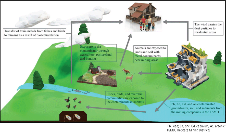
High-grade uranium ore was discovered in geologic features called “breccia pipes” in the Grand Canyon region during the late 1940s and became the subject of intense exploration during the 1970s (Otton and Van Gosen, 2010). Despite decreasing market values in the early 1980s, some uranium mining persists in the Grand Canyon region because of the high ore grades present in these deposits (Otton and Van Gosen, 2010). Price increases of uranium from 2005 to 2007 renewed interest in mining, which led to thousands of new mining claims in the Grand Canyon region (Otton and Van Gosen, 2010). Growing public concern that uranium mining activities could have adverse environmental, cultural, and social impacts prompted a 2-year withdrawal of approximately 1 million acres (404,686 hectares) of Federal lands from future mineral extraction to study the potential effects of uranium mining (Alpine, 2010) and to prepare an environmental impact statement (Bureau of Land Management, 2011). In 2012, the former Secretary of the Interior, Ken Salazar, closed the Federal lands in the Grand Canyon watershed to new mining claims under the 1872 Mining Law until the year 2032 (Bureau of Land Management, 2012; U.S. Department of Interior [DOI], 2012). The U.S. Geological Survey (USGS) was tasked by the DOI to address scientific data gaps identified in the associated Record of Decision (DOI, 2012). Specifically, the USGS identified critical scientific studies to reduce the unknowns and uncertainties associated with the environmental effects of uranium mining by focusing on the natural formation and distribution of uranium ore; characterizing radiation and chemical exposure to mining-related elements in air, water, sediment, soil, animals, and plants; prioritizing the adverse health effects of exposure; and determining biological effects of exposure to uranium and other trace elements (USGS, 2014). The proximity of the breccia pipe uranium mines to the Grand Canyon has increased the scrutiny of mining operations, and outcomes from risk analyses are of interest to a broad group of stakeholders (fig. 1; Hinck and others, 2021). Mines located on Federal lands require natural resource managers to balance the protection of public and natural resources with sustainable production of fuel minerals. Industry stakeholders may use the risk models for planning environmental mitigation and (or) remediation strategies. The environmental consequences of uranium extraction remain a concern despite the small footprints of these breccia pipe uranium mining operations, generally less than 20 acres (Alpine, 2010), because the Grand Canyon and surrounding areas host cultural and economic resources that are important to Tribes, ranchers, and recreational users. Tribal nations and environmental groups have expressed concern about potential mining impacts to cultural properties/resources and natural resources. Private citizens, such as landowners and recreational users, may have questions related to their property protection or activity safety. The mere concept of uranium mining can elicit perceptions of risk associated with radioactivity that may not be supported by empirical data. Such perceptions may ignore the complex nature of these mining sites, including the presence of natural sources of radioactivity, chemical as well as radiological risks, contaminants of concern that need to extend beyond uranium, and the potential bioaccumulation of elements and radionuclides into the local food web (Hinck and others, 2017; Bern and others, 2019; Cleveland and others, 2019, 2021a; Van Gosen and others, 2020).
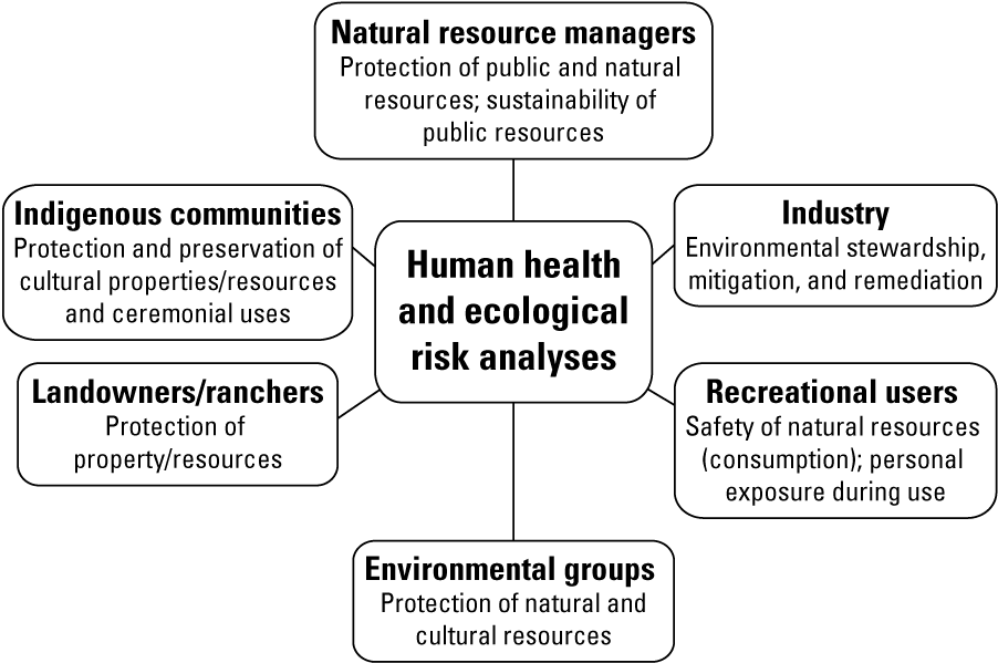
Examples of groups and their potential interests in human health and ecological risk analysis results at mining sites (modified from Hinck and others, 2021).
The USGS has published several risk analyses associated with breccia pipe uranium mines. Hinck and others (2014) developed a conceptual framework for the Canyon Mine (currently known as the “Pinyon Plain Mine”) that represented contaminant sources and physical, chemical, and biological processes that affect contaminant transport to ecological receptors. Other publications focused on risks for specific species (Hinck and others, 2013) or ecosystem components (Hinck and others, 2021). USGS efforts have focused on quantifying risk to wildlife, rather than humans, because other agencies such as the U.S. Environmental Protection Agency are generally responsible for such assessments. However, USGS interactions with Grand Canyon National Park and Kaibab National Forest Tribal liaisons revealed an overlap of ongoing USGS research initiatives with mining exposure concerns of different Tribes, which also aligned with the withdrawal justification that “it is likely that the potential impacts to Tribal resources could not be mitigated. Any mining within the sacred and traditional places of Tribal peoples may degrade the values of those lands to the Tribes that use them…” (DOI, 2012, p. 9). Literature reviews revealed that published risk models have largely ignored exposure pathways relevant to Tribal communities in terms of traditional uses and existential values of the resources (for example, Harris and Harper, 1997; Alexander, 2021). Exclusion of such uses can underestimate exposure risks to Tribal communities and ignore indigenous knowledge contributions to the Federal decision-making process. Given these factors, USGS determined it would be appropriate to update the conceptual risk framework for breccia pipe uranium mines to include Tribal perspectives.
This report helps to identify Tribal resources of concern to update the conceptual risk framework for breccia pipe uranium mines. Tribal resources from the Havasupai Tribe are used to illustrate this added perspective. The updated framework is applied to Red Butte, which is approximately 16 kilometers from the south rim of the Grand Canyon (fig. 2) and near an active uranium development. Red Butte is considered sacred as an important gathering place for multiple federally recognized tribes (Bureau of Indian Affairs, 2021) including the Havasupai, Hopi, Zuni, and Navajo (Hedquist and Ferguson, 2010). The Havasupai perspective is the focus of this report because of their willingness to publicly share their mining concerns (for example, Winters, 2016; Bleir, 2017; 2018; Tilousi, 2019). As descendants of the original peoples who have lived in the Grand Canyon for centuries, the Havasupai have long and deep connections to water, plants, animals, and geology throughout the Colorado Plateau. Future applications of the framework would need to be modified for other Tribes to accurately reflect their perspectives and knowledge systems.
Although the 20-year mining withdrawal ended with the area being designated as the Baaj Nwaavjo I’tah Kukveni – Ancestral Footprints of the Grand Canyon National Monument on August 8, 2023 (White House, 2023), breccia pipe uranium mining can continue within the monument where permitted claims already exist and areas outside the designated monument boundary. Therefore, applying the updated framework, presented in this document, could help guide future studies by DOI agencies. The report is organized to introduce (1) mining history near sacred Tribal areas, (2) culture and identity of the Havasupai Tribe that affects their perspective to mining, and (3) an updated conceptual risk framework for uranium mining that considers Havasupai culture and identity. Ideally, application of the framework and other research can be used along with indigenous knowledges in Federal research and decision making for mining in the Grand Canyon region.
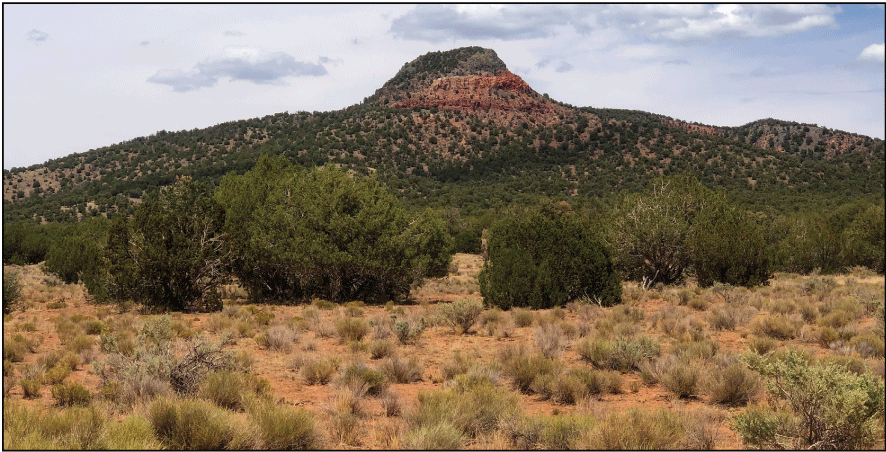
Red Butte (Wi’i Jgwal Gwa) in Arizona, near the town of Tusayan.
Methods
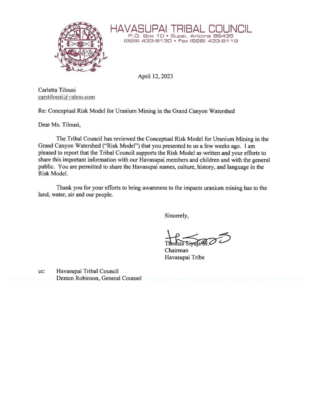
The conceptual risk framework developed for this report was based on standard risk analysis approaches (for example, Hinck and others, 2014; Park and others, 2020) but modified to include indigenous knowledge components and pathways. Havasupai indigenous knowledge was shared by multiple Tribal knowledge holders from 2015 to 2022 at formal meetings (in Flagstaff and Supai Village, Arizona), mine site visits with other Federal agencies (Grand Canyon National Park, Kaibab National Forest), virtual teleconferences, and one-on-one meetings. Knowledge holders included Tribal elders, elected Tribal Council members, and Tribal members selected to represent the Havasupai on specific topics (for example, uranium mining), all of whom are accepted as wise leaders within the Havasupai community. Information was also obtained from other published sources (for example, Atencio, 1996; Hirst, 2006; Hedquist and Ferguson, 2010; Tikalsky and others, 2010). Drafts of the framework were shared with Tribal knowledge holders to validate the inclusion of specific indigenous knowledge. To gain approval for publishing the indigenous knowledge as part of the risk framework, the authors presented this report, by reading word for word, to the Havasupai Tribal Council (7 members) during the January 19, 2023, Tribal council meeting. Council members offered some small edits (for example, Havasupai spelling corrections, adding elder’s names to historical pictures), and a revised version was provided to the Havasupai Tribal Council (February 14, 2023). The Havasupai Tribal Council approved the conceptual risk framework and granted permission to share Havasupai names, culture, history, and language in this report (April 12, 2023; appendix 1). This iterative review process with the knowledge holders and the approval from the Havasupai Tribal Council signifies that the included indigenous knowledge is not the opinion of individuals within the Tribe but rather represents the consensual indigenous knowledge and sacred beliefs that the Havasupai people are choosing to share with the public in this report. In addition, this report meets guidance from the White House Office of Science and Technology Policy and the Council on Environmental Quality on including indigenous knowledge in Federal research and decision making (Office of Science and Technology Policy and Council on Environmental Quality, 2022).
The expanded conceptual risk framework was used to identify new exposure pathways relevant to indigenous communities and includes Havasupai nomenclature to help preserve the language and historical cultural practices for future generations. The report includes the official geographic names as referenced in the U.S. Board on Geographic Names (https://www.usgs.gov/us-board-on-geographic-names) as well as the Havasupai nomenclature. Although none of the Havasupai names were included in the geographic names database, their inclusion in this report is essential for Tribal members to understand the conceptual framework as it relates to their community.
Uranium Mining near Tribe’s Sacred Mountain
The Pinyon Plain Mine (lat 35°52’57.50” N, long 112°05’44.52” W) is within the Kaibab National Forest about 5 kilometers from Red Butte (Wi’i Jgwal Gwa; lat 35°49’12.76” N, long 112°5’23.56” W), which is one of the sites related to Havasupai creation stories (fig. 3; Atencio, 1996). Red Butte is also sacred to the Hopi (Oawinpi), Navajo (Tse zhin e’ahi), and Zuni Tribes (Hedquist and Ferguson, 2010). The mine, which is owned and operated by Energy Fuels, Inc., is rich in uranium and copper (Mathisen and others, 2023) and is in an area the Havasupai call Mat Taav Juudva (roughly translated as “sacred meeting corridor”). The area was designated as a Traditional Cultural Property by the U.S. Forest Service in 2010, but this designation did not exempt Red Butte and the surrounding area from renewed mining operations at the Pinyon Plain Mine (Winters, 2016). Energy Fuels, Inc., changed the name of the mine to Pinyon Plain Plain in 2020; it had previously been known as the Canyon Mine since at least the 1980s (U.S. Department of Agriculture, 1986). Pinyon Plain Mine development has been completed but no ore has been extracted to date (as of December 2023; Energy Fuels, Inc., 2023); future mining is possible dependent on decisions by Energy Fuels, Inc.
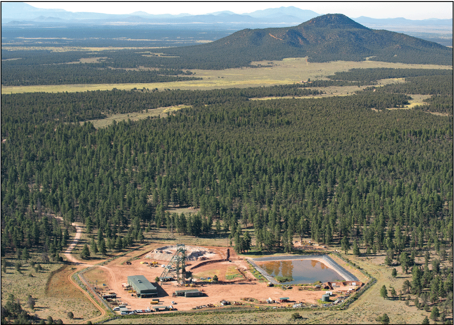
The Pinyon Plain mine (foreground) is located near Red Butte (near background) in Northern Arizona. Photograph by Blake McCord, freelance photographer.
The Havasupai Tribe has spoken out against mining at the Pinyon Plain Mine through lawsuits, injunctions, and protests. They have voiced concerns to the U.S. Government and the international community that uranium mining may cause death and destruction to their waters and to the existence of their life and traditional practices (U.S. Congress, 2019). In 2012, the Havasupai believed that DOI heard their voices when enacting the 20-year mining withdrawal, which meant that for two decades there would be no new uranium mines on Federal land on the north and south rims of the Grand Canyon (DOI, 2012); however, existing permitted mines, including the Pinyon Plain Mine, were grandfathered into this withdrawal. The Havasupai have continued to oppose the opening of the Pinyon Plain Mine through partnerships with nongovernmental organizations including the Sierra Club, Center for Biological Diversity, and the Grand Canyon Trust. Federal courts have ruled against their appeals to stop mining at the Pinyon Plain Mine (United States District Court for the District of Arizona, 1990, 2015; United States Court of Appeals for the Ninth Circuit, 1991, 2017, 2022; Winters, 2016).
Havasuw baja—People of the Blue Green Water
The Havasupai population is 755 Tribal members (as of July 2023), making it one of the smallest federally recognized Tribes in North America. Their reservation consists of 74,867 hectares of the Grand Canyon, which was made by congressional action of the Grand Canyon National Park Enlargement Act of 1975 (Public Law 93–620, 88 Stat. 2089). Havasupai, or Havasuw baja, means People of the Blue Green Water. This name comes from travertine-rich water that forms several distinctive waterfalls in the canyon formed by Havasu Creek.
Historically, many Pai Tribes inhabited the land around the Grand Canyon, including the Havasupai, Hopi, Hualapai, Southern Paiute, Yavapai-Apache, and Zuni (fig. 4). Important geographical landmarks included the Grand Canyon, the San Francisco Peaks, Bill Williams Mountain, and Red Butte. The Havasupai Tribe roamed the rim of the Grand Canyon and the Colorado Plateau in the winter and spent summers farming in the bottom of the Grand Canyon (Hirst, 2006). When the U.S. Government seized most of their aboriginal territory by executive order in 1882, the Havasupai were locked into 519 acres within the Havasu Canyon along Cataract Creek (fig. 5; Grand Canyon National Park, 2021); their village, known as Supai, is only accessible by foot, horse, or helicopter. The Havasupai’s indigenous aboriginal territory includes the Grand Canyon National Park, which is home to sacred trails, prayer areas, mountains, and burial sites. In 2022, the Havasupai successfully petitioned the name change of Indian Gardens to Ha’a Gyoh (Havasupai Gardens), honoring their ancestors and reclaiming their historical connection to the Grand Canyon (National Park Service, 2022; Fonseca, 2023). The Havasupai have important connections to the water and waterfalls in the region (figs. 6 and 7). Traditional practices in Supai include farming (melons, peaches [Prunus persica], and corn [Zea spp.]) and packing supplies in and out of the canyon. Specific animals are considered ancient relatives to the Havasupai; for example, the bighorn sheep (Ovis canadensis) roamed in the canyons for many years and protect the Havasupai people according to their oral teachings (Bleir, 2018).
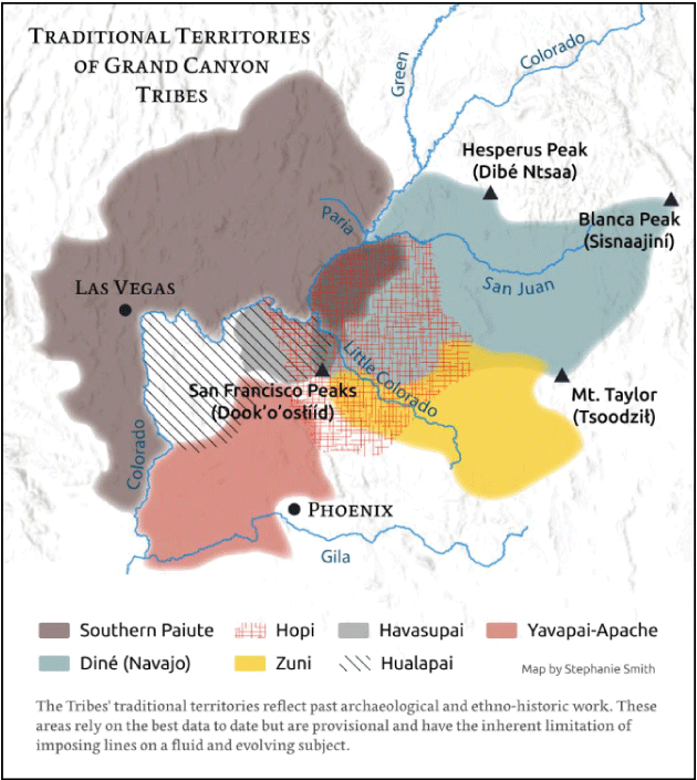
Traditional territories of Grand Canyon Tribes including the Havasupai. Map from Krakoff (2020).
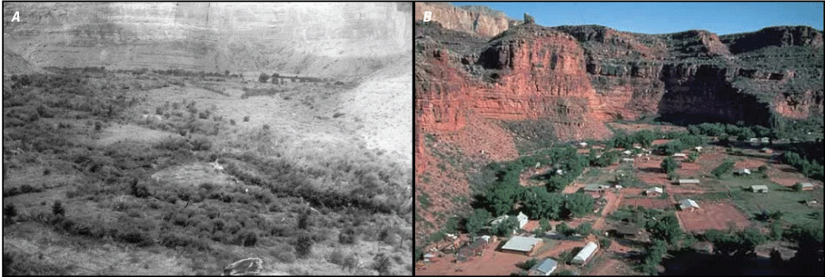
Area of Havasupai village, known as Supai, within the Havasu Canyon. A, Supai in 1893 (Coupland, 1893). B, Supai in 2016 (photograph courtesy of National Park Service).
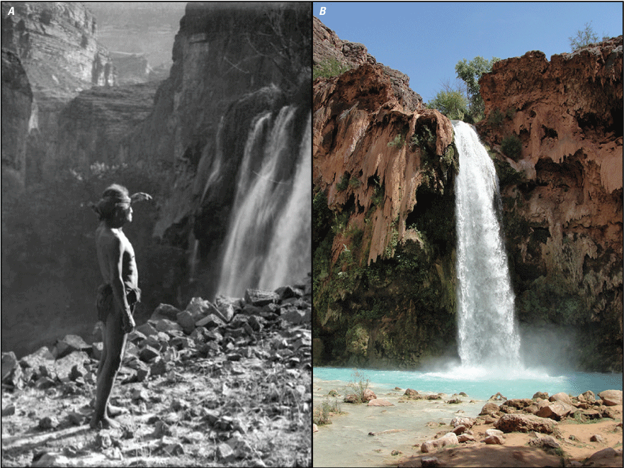
Area of Havasu Falls within the Havasu Canyon. A, Havasu Falls around 1907–13 (Kolb, 1907). B, Havasu Falls in 2016.
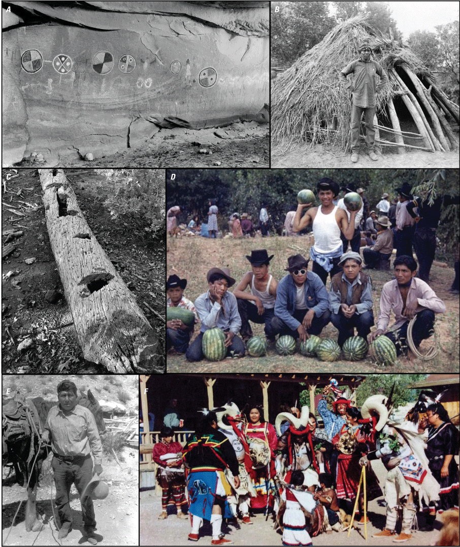
Havasupai Tribe presence in canyons of the region. A, Ancient rock writings of the Pai Tribes in Havasu Creek area (James,1900). B, Waluthma (also known as Supai Charlie) in front of a wikiup, 1901. Remnant of these structures can still be found along trails in the Grand Canyon (Peabody, 1901). C, Water storage log found at plateau camp near south rim of Grand Canyon, 1920s (photograph by National Park Service). D, Watermelon harvest in Supai, 1950 (Belknap, 1950). E, Packer and wrangler Bela Wescogame, near Hill Top, 1929 (photograph by National Park Service). F, Ram dance celebration, Supai, 1993 (photograph by Guardians of the Grand Canyon).
Connections with the Land
Ceremonial or medicine wheels are often used to represent important indigenous connections (for example, Twigg and Hengen, 2009; Wenger-Nabigon, 2010; Bell, 2014). The wheel for the Havasupai is based on four foundational aspects of culture and tradition with direct relations to Red Butte (fig. 8). These include the environment, belief systems, ceremony, and food, which are all interconnected and thus inseparable, and were essential to include in the conceptual risk framework (for example, appendix 2). Environment represents the natural world in which they live. Food represents dietary sustenance. Ceremony represents healing and cleansing aspects of culture. Belief systems represent the connectedness of all things and teachings from elders to others. The Havasupai, as many native peoples across the region, have a deep connection with Red Butte and the Grand Canyon that affects their perspective of mining. They believe that the area has specific strengths and deities that warrant giving gifts or offering, either individually or in groups. Havasupai oral histories and belief systems taught through their grandparents and parents (Tikalsky and others, 2010) illustrate that every living plant and animal has a role on this earth and a specific spirit that should be protected. This reciprocity with nature has been described as integral to survival—not only for the ecosystem but humans themselves (Wall Kimmerer, 2013).
Ceremonial gatherings with worshiping, singing, and dancing were common at Red Butte until the 1980s, when the U.S. Government asserted that the Havasupai had no traditional or cultural connection to the area (Winters, 2016). This assertion was somewhat rectified in 2010 when the U.S. Forest Service designated Red Butte and the surrounding area as a Traditional Cultural Property through the National Historic Preservation Act (Mike Lyndon, National Park Service, written commun., November 28, 2023; Winters, 2016). However, this sacred area remains under the ownership of the U.S. Government as part of Kaibab National Forest and was designated as part of the Baaj Nwaavjo I’tah Kukveni– Ancestral Footprints of the Grand Canyon National Monument in August 2023 (White House, 2023).
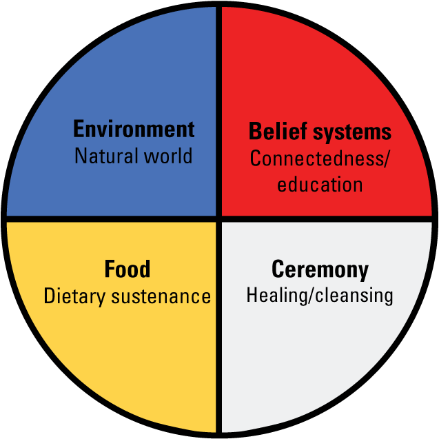
Foundational aspects of Havasupai culture and tradition.
Quotes from Havasupai members describing use of Red Butte and other sacred areas to the Tribe (Bleir, 2017)
“We have found the only way we can protect a thing that we do not want disturbed is by being very, very silent. Not speaking about that painting, that rock, what is behind that rock, because we know what is going to happen to these things if we talk about them. They are going to be destroyed.”
—Rex Tilousi, elder and former Chairman of the Havasupai
“People complain that we have no documentation of being in the [area] and say such things like ‘we have never seen them here.’ But animals and plants are still a very profound part of the survival of the Havasupai people, and we have been constantly utilizing these lands over generations.”
—Uqualla, a Havasupai Medicine Man and Spiritual Traditionalist
Connections with the Water
Concerns about potential effects to water from uranium mining was a driving factor of the mining withdrawal (DOI, 2012). Water is essential to Havasupai identity and its importance is passed from elders to Havasupai children through oral stories (for example, Tikalsky and others, 2010). The Havasupai note that the people’s existence and belief systems are at risk of serious effects that cannot be mitigated if the water becomes contaminated from uranium mining (Tilousi, 2019). The Pinyon Plain Mine is above a primary aquifer, the Redwall-Muav aquifer or R-aquifer, on the Colorado Plateau (Pool and others, 2011). Havasupai Vice-Chairman Edmond Tilousi recently noted “If the R-Aquifer becomes contaminated, and we must abandon our ancestral home of Supai Village, we will leave the blue-green waters of Havasu Creek behind and consequently will cease to be the Havasuw baja. While we may still breathe air, we, the People of the Blue Green Water, will have become extinct.” (Tilousi, 2022, p. 15). A perched aquifer at the Pinyon Plain Mine site was encountered during the sinking of the mine shaft around 2016 (Energy Fuels, Inc., 2016, 2017); large volumes of water from the perched aquifer have continued to drain into the mine shaft (Energy Fuels, Inc., 2018, 2019, 2020, 2021, 2022). The act of puncturing the aquifer itself contaminates the air and the water according to the Havasupai belief systems (U.S. Congress, 2017) even though uranium ore has yet to be produced at the Pinyon Plain Mine. Furthermore, water loss mitigation plans are not in place; currently (as of December 2023), Energy Fuels, Inc. treats the water from the aquifer for uranium and arsenic and holds it in tanks for onsite use (for example, dust control; Arizona Department of Environmental Quality, 2022). Traditional ecological risk analysis considers various components of the environment (for example, Hinck and others, 2014; Park and others, 2020). Likewise, components of the environment, including all the plants and animals, are important to the Havasupai. The people’s communion with these plants and animals reflects the traditional uses of the Havasupai, and such uses can introduce unique exposure pathways not considered in the original conceptual risk framework (Hinck and others, 2014). For example, the Havasupai have long been known for the quality of their tanned deer-hides (fig. 9). Traditional hide processing includes hand and mouth contact with deer organs and fluids, which could expose hunters to contaminants in the animal (Hirst, 2006). Another example is whether the medicinal and ceremonial use of big sagebrush (Artemisia tridentata) and Utah juniper (Juniperus osteosperma) collected near Red Butte increases contaminant exposure risk given its proximity to the Pinyon Plain Mine.
Differing viewpoints on the development of the Pinyon Plain Mine in Arizona
“We have a belief system that they don’t understand,” says the Havasupai elder Carletta Tilousi. “In our stories, that are where the mine is located is Mother Earth’s lungs. So when they dug the mine shaft, they punctured her lungs.” (McGiveny, 2022)
“The Pinyon Plain mine is only about 17-acres in size” said Energy Fuels VP Curtis Moore. “It is a small underground mine, so there will not be a big open pit or other significant disturbance. Once mining is completed, the Pinyon Plain mine site will be fully reclaimed and returned to its former use, including recreation, forestry, wildlife conservation, etc.” (Bindell, 2022)
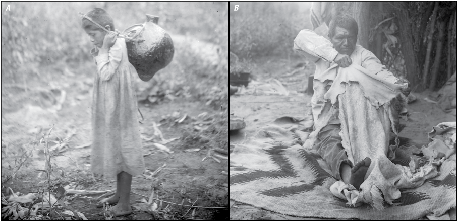
Havasupai culture emphasizes connections with water and animals. A,– Havasupai girl carrying an ha sua or water jug, 1900 (Pierce, 1900a). B, Havasupai man (Lemuel Paya, former Havasupai Tribal Chairman) dressing a deer hide, circa 1900 (Pierce, 1900b).
Conceptual Risk Framework for Uranium Mining—An Update to Include Havasupai Resources at Risk
Conceptual risk models are a working hypothesis of how contaminants at a site may affect the surrounding ecosystem. Historically, model components include sources of contaminants, routes of exposure, and endpoint receptors (Suter, 1996). Conceptual risk models for mining sites are typically conducted from a western science perspective, focusing on human health (for example, U.S. Environmental Protection Agency, 2006, 2014) or ecological risk (for example, U.S. Environmental Protection Agency, 1992, 2003; fig. 10). Western science has been defined as a knowledge system that relies on application of the scientific method to phenomena in the world in which a proven hypothesis can become theory or truth (Mazzocchi, 2006). However, these risk models lack the Tribal or indigenous knowledge as seen by recent research opportunities from the U.S. Environmental Protection Agency to expand inclusion of indigenous perspectives into environmental health research (for example, U.S. Environmental Protection Agency, 2023a, 2023b). This deviation from equitable co-existence between humans and nonhuman beings is inconsistent with foundational understanding of many indigenous cultures (Tribal Adaptation Menu Team, 2019). Models that include indigenous knowledge are being developed by groups such as the National Tribal Toxics Council (2015) and the Pueblo de San Ildefonso (2023).
This report describes an updated risk framework for uranium mining with relevant traditional and ceremonial exposure pathways from the Havasupai perspective. The framework is presented in English (fig. 11) and Havasupai (fig. 12) to aid Tribal members in understanding how the conceptual framework relates to their community. Note that conceptual risk models identify pathways of concern but are not intended to validate or quantify actual contaminant exposure. This framework uses Pinyon Plain Mine and Red Butte as examples, but resources and pathways may be applicable to other mining locations. The framework (figs. 11 and 12; table 1) flows to humans to signify the interconnectedness the Havasupai have with the environment. The updated framework identifies contaminant exposure pathways that are typical of the western science perspective—what humans and animals are eating, breathing, and drinking near the uranium mine—but are also relevant to Havasupai traditional uses (figs. 11 and 12). The Havasupai are particularly concerned about inhalation of uranium and other elemental contaminants moving through the air (for example, dust) from the mining operations to the surrounding area, including Red Butte. Exposure to contaminants by eating plant foods (for example, piñon nuts and yucca) and game (for example, elk (Cervus elaphus canadensis), mule deer (Odocoileus hemionus), porcupine (Erethizon dorsatus), and black-tailed jackrabbit (Lepus californicus) harvested near the mine is a concern (fig. 13). Drinking contaminated groundwater is also a priority concern of the Havasupai. This shared indigenous perspective has resulted in USGS conducting new research that focuses on Tribal resources of interest, including chemical characterization in elk tissues (Cleveland and Hinck, 2021b), chemical exposure in traditional uses of sagebrush (Cleveland and Hinck, 2019), and particulate air monitoring (USGS, 2023).
Typical conceptual site framework for a mining site that highlights human health and ecological risk assessment considerations. From Park and others (2020).
An update to the framework includes adding exposure pathways that are of concern to the Havasupai based on their traditional ways (fig. 11). As previously mentioned, additional exposures can occur through preparing game hides, which are processed in specific ways that includes extensive contact with skin and mouth. Similarly, medicinal plants (for example, sage, piñon sap, juniper berries) and body/face painting materials (for example, red orche, charcoal, gypsum) used on the skin introduce other important indigenous exposure pathways to consider (fig. 13). The Pinyon Plain Mine area, known to the Havasupai as Mat Taav Juudva, is important for medicinal and ceremonial plant collection. Collected plants may introduce unique or more complex exposure pathways such as skin contact (dermal exposure) and breathing (inhalation). In addition, traditional uses of some medicinal plants may have specific preparatory procedures that exclude washing, which introduces dust exposure pathways into the framework. Incorporating components of these Havasupai traditional uses into USGS studies could include chemical characterization of source material (medicines, painting materials) not previously considered in the research related to the 20-year mining withdrawal. The framework could also be useful to human health researchers in designing their risk analyses.
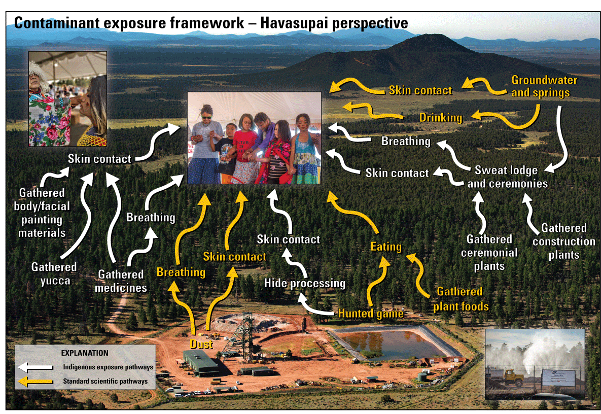
Contaminant exposure framework for uranium mining in the Grand Canyon region from the Havasupai perspective. Photographs by Blake McCord and Dawn Beauty.
Traditional ceremonies such as dancing, praying, and singing held at Red Butte were described previously but are also important to consider in the updated conceptual risk framework. The area of Red Butte is essential for purification or cleansing for the Havasupai people and other Tribes (Hedquist and Ferguson, 2010). Specific ceremonies take place at critical points in a Havasupai member’s life—infancy, adolescence, and adulthood. Sweat lodges near Red Butte are used for traditional practices and also pose unique scenarios for contaminant exposure (fig. 14). The Havasupai use sweat lodges for infant blessings, youth entering adulthood, healing of broken bones, and social/group prayer. There are concerns that contaminant exposure is increased as members are in a confined space inhaling water vapor (steam) and particulates from burning of sage and juniper. Therefore, exposure pathways that consider contaminants in ceremonial plants, water, and construction materials need to be included in the framework (fig. 11). New exposure pathway examples include breathing in the smoke from juniper or sage smudging or the steam in a sweat lodge. Additional studies could be designed to simulate exposure based on material sources, ceremony duration, and activities during confinement (for example, singing compared with silent meditation). The concept of the ceremonial wheel is integrated into the conceptual risk framework in figure 13. Recall that the wheel includes food, environment, belief systems, and ceremony. The food component is the most readily identifiable in a western science risk analysis and includes water and harvested plants (such as piñon nuts, yucca) and animals (such as mule deer, elk). Another important component is the environment, which includes relatives and residents of Mother Earth such as coyote (Canis latrans), bald eagle (Haliaeetus leucocephalus), and red-tailed hawk (Buteo jamaicensis). These resources are not consumed directly but are important to creation stories and have existence value (Hirst, 2006; Tikalsky and others, 2010). Ecological risk assessment approaches may consider including species that are important to the Havasupai and other species that may be relevant to other Tribes in the region. The ceremonial component includes medicinal plants and resources for cleansing and healing such as sage, juniper, and devilsclaw (Proboscidea parviflora). The belief systems component is connected to all the resources in figure 13 because they are important to the Havasupai ways of knowing and being. These cannot be separated out—or left out—when considering the risks of uranium mining at the Pinyon Plain Mine. As such, the picture of Havasupai members at the center of the framework signifies that changes to any of these resources affect them as peoples.
Building on this interconnectedness, the Havasupai belief systems teach that change or loss happens once Mother Earth is disturbed; change or loss does not wait until a mine goes into official ore production. Examples of this at Pinyon Plain Mine is the loss of water from the perched aquifer during the sinking of the mine shaft and the removal of traditional plants to build the mine yard. A challenge in applying the framework is based around this concept. Common risk assessment approaches attempt to quantify the risk by applying hazard quotients or setting protective toxicity thresholds, indicating that some degree of change or loss is acceptable. Such an approach may be deemed irrelevant by Tribal communities; for example, the Havasupai have changed certain traditional behaviors to mitigate exposure based on their risk perspective to mining near Red Butte. These include (1) instructing Tribal members and the public to not harvest plants or animals near the mine or along the mining haul road; (2) limiting camping near the mine; (3) limiting the amount of time at the mine site, despite the area being part of their creation story; and (4) altering ceremonial ways (location and how the ceremony is conducted), which weakens their connections to Mother Earth. Their cultural belief systems have been disrupted historically with their relocation to Havasu Canyon, which separated them from sacred places like Red Butte. Proximity to sacred places is important to their belief systems because the sacred places cannot be recreated in another location (Tilousi, 2022).
Admittedly, these complex relations that the Havasupai Tribe have with their surroundings cannot be fully addressed in the updated conceptual risk framework. Loss or separation of culture and identity cannot be evaluated in any such framework. Nevertheless, the updated framework has allowed USGS to take first steps in understanding important resources to the Havasupai, building relationships to improve co-production in our research, and potentially addressing additional concerns outlined in the original withdrawal record of decision (appendix 1). Despite the national monument designation, permitted mines can continue, which underscores the continuing need to study risks of uranium mining in the region. Ideally, application of the framework and other research can be used along with indigenous knowledges in Federal research and decision making for mining in the Grand Canyon region (Office of Science and Technology Policy and Council on Environmental Quality, 2022).
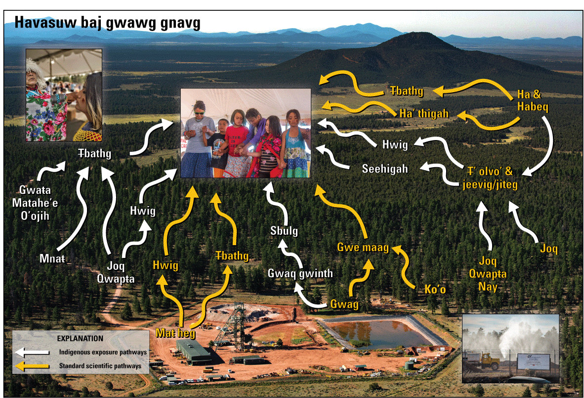
Contaminant exposure concerns for uranium mining in the Grand Canyon region from the Havasupai perspective in their indigenous language. Photographs by Blake McCord and Dawn Beauty.
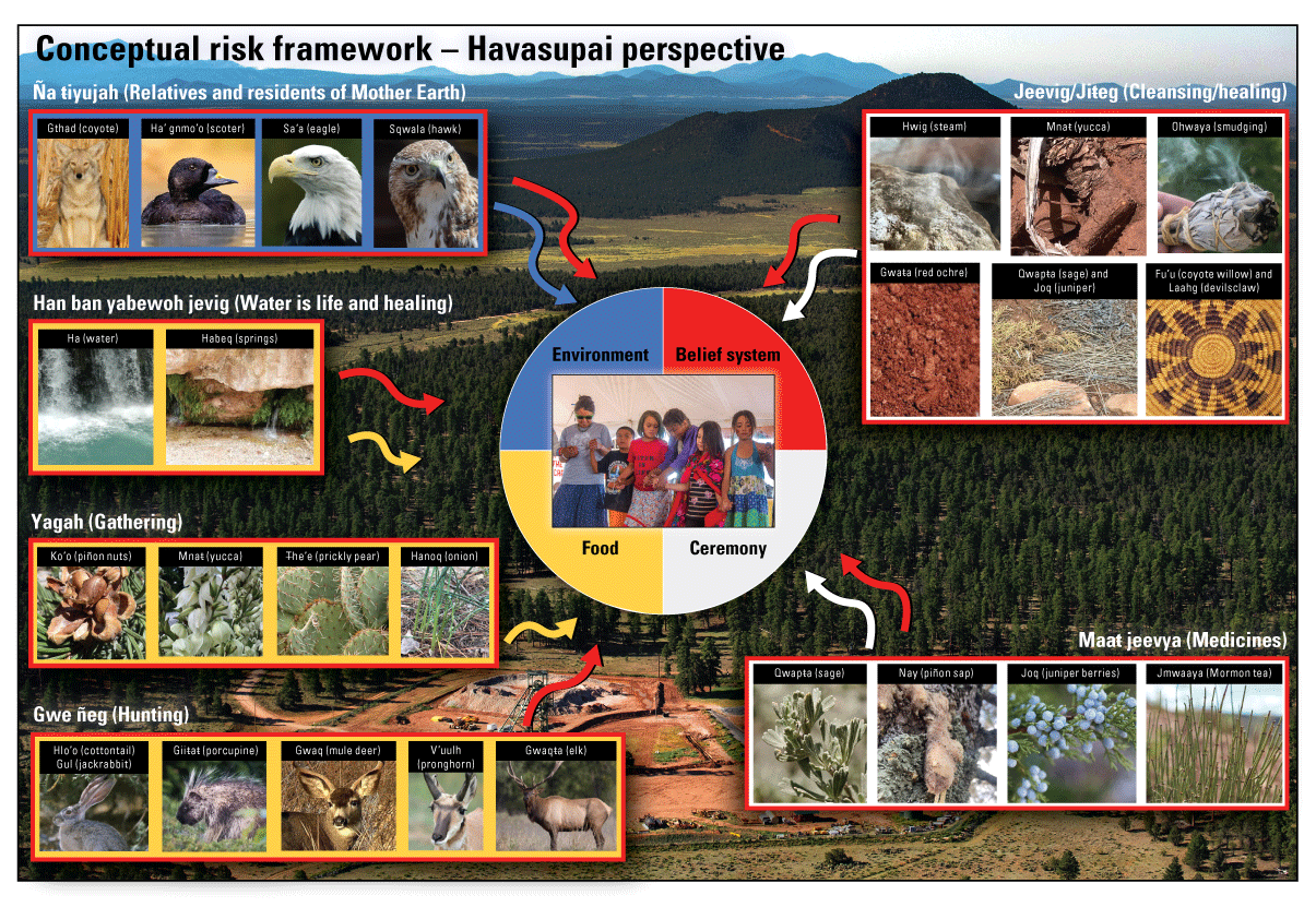
Examples of relatives, resources, and activities that illustrate exposure concerns for uranium mining in the Grand Canyon region from the Havasupai perspective, as it relates to their ceremonial wheel. Special copyright notifications for photograph of red-tailed hawk at https://commons.wikimedia.org/wiki/File:Red-tailed_hawk_in_Central_Park_(24796).jpg. Scientific names are provided in table 1.
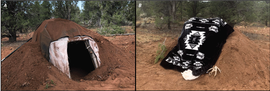
Sweat lodge (t’ olvo’) near Red Butte where Havasupai ceremonies are an example of specific contaminant exposure concern. A, Front of sweat lodge. B, Traditionally, a buffalo hide (mthiñ) would cover the entrance rather than a blanket.
Table 1.
Common, Havasupai, and scientific names of plants and animals.Summary
As descendants of the original peoples who have lived in the Grand Canyon for centuries, the Havasupai have long and deep connections to water, plants, animals, and geology throughout the Colorado Plateau. The updated conceptual risk framework identifies Tribal and cultural resources of concern to the Havasupai in the context of uranium mining. These resources have not been previously identified and placed in a risk framework. The newly identified exposure pathways can be evaluated by scientists studying data gaps as they relate to the mining withdrawal. For example, new study considerations may be given to dermal and inhalation exposures of using medicinal and ceremonial plants or traditional processing of harvested plants and animals. Ecological risk analyses could consider species identified in the framework to be more inclusive of Tribal and cultural resources. In addition, this framework could be modified by other Tribes in the area to evaluate risks to their Tribal and cultural resources. Including Havasupai nomenclature in the framework also helps preserve the language and historical cultural practices for future generations. Social science studies may be considered given the behavioral changes already documented by the Havasupai people at the Pinyon Plain Mine. Ideally, application of the framework and other research can be used along with indigenous knowledge systems in Federal research and decision making for mining in the Grand Canyon region.
References Cited
Alexander, I., 2021, Evaluating tribal dietary, lifestyle, and ceremonial exposure for use in EPA Superfund Risk Assessment: U.S. Environmental Protection Agency, 40 p., accessed July 3, 2023, at https://semspub.epa.gov/work/HQ/100002840.pdf.
Alpine, A., ed., 2010, Hydrological, geological, and biological sites characterization of breccia pipe uranium deposits in northern Arizona: U.S. Geological Survey Scientific Investigations Report 2010–5025, 353 p., 1 pl., scale 1:375,000, accessed August 21, 2023, at https://doi.org/10.3133/sir20105025https://pubs.usgs.gov/sir/2010/5025/.
Arizona Department of Environmental Quality, 2022, Aquifer Protection Permit No. P-100333: Arizona Department of Environmental Quality, 39 p., accessed August 21, 2023, at https://static.azdeq.gov/wqd/pinyonplain/2022_indpermit.pdf.
Atencio, E., 1996, Havasupai traditional and historical use of the Grand Canyon village area: Grand Canyon/Havasupai Oral History Project, Grand Canyon National Park, 37 p., accessed November 3, 2022, at http://landcultureconsulting.com/wp-content/uploads/Havasupai-Grand-Canyon_no-appendices.pdf.
Bern, C.R., Walton-Day, K., and Naftz, D.L., 2019, Improved enrichment factor calculations through principal component analysis—Examples from soils near breccia pipe uranium mines, Arizona, USA: Environmental Pollution, v. 248, p. 90–100. [Also available at https://doi.org/10.1016/j.envpol.2019.01.122.]
Bindell, S., 2022, Energy Fuels confident ADEQ decision will be upheld at Pinyon Plain Mine: Navajo-Hopi Observer, accessed August 1, 2022, at https://www.nhonews.com/news/2022/may/10/energy-fuels-confident-adeq-decision-will-be-uphel/.
Bleir, G., 2017, Desecrating medicine, contaminating water, defiling sacred land: Intercontinental Cry, accessed August 1, 2022, at https://intercontinentalcry.org/desecrating-medicine-contaminating-water-defiling-sacred-land/.
Bleir, G., 2018, Havasupai prayer gathering—Indigenous nations unite against nuclear colonialism: Intercontinental Cry, accessed August 1, 2022, at https://intercontinentalcry.org/havasupai-prayer-gathering-indigenous-nations-unite-nuclear-colonialism/.
Bureau of Indian Affairs, 2021, Indian entities recognized by and eligible to receive services from the United States Bureau of Indian Affairs: Federal Register, v, 86, no. 18, p. 7554–7558, accessed November 9, 2023, at https://www.federalregister.gov/documents/2021/01/29/2021-01606/indian-entities-recognized-by-and-eligible-to-receive-services-from-the-united-states- bureau-of.
Bureau of Land Management, 2011, Northern Arizona proposed withdrawal—Final environmental impact statement, Volumes 1 and 2: U.S. Department of the Interior, Bureau of Land Management, BLM/AZ/PL-11/002, accessed November 9, 2023, at https://permanent.fdlp.gov/gpo26632/Complete.pdf.
Bureau of Land Management, 2012, Public Land Order No. 37787; Withdrawal of public and national forest system lands in the Grand Canyon watershed; Arizona: Federal Register, v. 77, no. 11, p. 2563–2566, accessed November 9, 2023, at https://www.federalregister.gov/documents/2012/01/18/2012-849/public-land-orderno-7787-withdrawal-of-public-and-national-forest-system-lands-in-thegra nd-canyon.
Cleveland, D.M., Hinck, J.E., and Lankton, J.S., 2019, Assessment of chronic low-dose elemental and radiological exposure of biota at the Kanab North uranium mine site in the Grand Canyon watershed: Integrated Environmental Assessment and Management, v. 15, no. 1, p. 112–125. [Also available at https://doi.org/10.1002/ieam.4095.]
Cleveland, D., and Hinck, J.E., 2019, Are Native Americans exposed to uranium mining-related elements in smoke particulates during traditional uses of sagebrush?: Presentation at 15th Biennial Conference of Science and Management on the Colorado Plateau, September 9–12, Flagstaff, Ariz., accessed November 9, 2023, at https://in.nau.edu/wp-content/uploads/sites/94/2019/09/15th-Biennial-Conference-Abstracts.pdf.
Cleveland, D., Hinck, J.E., and Lankton, J.S., 2021a, Elemental and radionuclide exposures and uptakes by small rodents, invertebrates, and vegetation at active and post-production uranium mines in the Grand Canyon watershed: Chemosphere, v. 263, p. 127908, accessed November 9, 2023, at https://doi.org/10.1016/j.chemosphere.2020.127908.
Cleveland, D.M., and Hinck, J.E., 2021b, Elements in elk tissues harvested in pre-uranium mining and non-mining areas, 2019: U.S. Geological Survey data release, accessed November 9, 2023, at https://doi.org/10.5066/P95I7UK2.
Energy Fuels, Inc., 2023, Pinyon Plain Mine: Energy Fuels, Inc., web page, accessed November 9, 2023, at https://www.energyfuels.com/pinyon-plain-mine.
Energy Fuels, Inc., 2016, Canyon Mine Non-Storm Water Impoundment 3.04 General Aquifer Protection Permit No. P-100333—Annual report for 2015: Lakewood, Colo., 44 p. [Report available by request from the Arizona Department of Environmental Quality at https://azdeq.gov/request-record.]
Energy Fuels, Inc., 2017, Canyon Mine Non-Storm Water Impoundment 3.04 General Aquifer Protection Permit No. P-100333—Annual report for 2016: Lakewood, Colo., 131 p. [Report available by request from the Arizona Department of Environmental Quality at https://azdeq.gov/request-record.]
Energy Fuels, Inc., 2018, Canyon Mine Non-Storm Water Impoundment 3.04 General Aquifer Protection Permit No. P-100333—Annual report for 2017: Lakewood, Colo., 144 p. [Report available by request from the Arizona Department of Environmental Quality at https://azdeq.gov/request-record.]
Energy Fuels, Inc., 2019, Canyon Mine Non-Storm Water Impoundment 3.04 General Aquifer Protection Permit No. P-100333—Annual report for 2018, Lakewood, Colo., 157 p. [Report available by request from the Arizona Department of Environmental Quality at https://azdeq.gov/request-record.]
Energy Fuels, Inc., 2020, Canyon Mine Non-Storm Water Impoundment 3.04 General Aquifer Protection Permit No. P-100333—Annual report for 2019, Lakewood, Colo., 153 p. [Report available by request from the Arizona Department of Environmental Quality at https://azdeq.gov/request-record.]
Energy Fuels, Inc., 2021, Canyon Mine Non-Storm Water Impoundment 3.04 General Aquifer Protection Permit No. P-100333—Annual report for 2020, Lakewood, Colo., 172 p. [Report available by request from the Arizona Department of Environmental Quality at https://azdeq.gov/request-record.]
Energy Fuels, Inc., 2022, Canyon Mine Non-Storm Water Impoundment 3.04 General Aquifer Protection Permit No. P-100333—Annual report for 2021, Lakewood, Colo., 114 p. [Report available by request from the Arizona Department of Environmental Quality at https://azdeq.gov/request-record.]
Fonseca, F., 2023, Forced from Grand Canyon National Park, the Havasupai Tribe embraces spiritual homecoming: The Associated Press, accessed May 16, 2023, at https://apnews.com/article/grand-canyon-havasupai-gardens-national-park-9ccc6faf7599a7cb75e3f52969d9590c.
Grand Canyon National Park, 2021, Senator Carl T. Hayden Papers (1851-1979) correspondence, maps, data, bills re: establishment as National Park, 1917–1918: Tempe, Ariz., ASU Library, Arizona State University, MSS 1. Greater Arizona Collection, accessed November 9, 2023, at https://hdl.handle.net/2286/R.I.49566.
Harris, S.G., and Harper, B.L., 1997, A Native American exposure scenario: Risk Analysis, v. 17, no. 6, p. 789–795. [Also available at https://doi.org/10.1111/j.1539-6924.1997.tb01284.x.]
Hedquist, S., and Ferguson, T.J., 2010, Ethnographic resources in the Grand Canyon: Interim report to the Grand Canyon National Park, 256 p., accessed November 3, 2022, at https://in.nau.edu/wp-content/uploads/sites/128/2018/08/UAZ-211-ek.pdf.
Hinck, J.E., Linder, G., Otton, J.K., Finger, S.E., Little, E., and Tillitt, D.E., 2013, Derivation of soil-screening thresholds to protect the chisel-toothed kangaroo rat from uranium mine waste in Northern Arizona: Archives of Environmental Contamination and Toxicology, v. 65, no. 2, p. 332–344, accessed November 9, 2023, at https://doi.org/10.1007/s00244-013-9893-5.
Hinck, J.E., Linder, G., Darrah, A.J., Drost, C.A., Duniway, M.C., Johnson, M.J., Méndez-Harclerode, F.M., Nowak, E.M., Valdez, E.W., van Riper, C., III, and Wolff, S., 2014, Exposure pathways and biological receptors—Baseline data for the Canyon uranium mine, Coconino county, Arizona: Journal of Fish and Wildlife Management, v. 5, no. 2, p. 422–440. [Also available at https://doi.org/10.3996/052014-JFWM-039.]
Hinck, J.E., Cleveland, D., Brumbaugh, W.G., Linder, G., and Lankton, L., 2017, Pre-mining trace element and radiation exposure to biota from a breccia pipe uranium mine in the Grand Canyon (Arizona, USA) watershed: Environmental Monitoring and Assessment, v. 189, no. 2, p. 1–23. [Also available at https://doi.org/10.1007/s10661-017-5765-1.]
Hinck, J.E., Cleveland, D., and Sample, B.S., 2021, Terrestrial ecological risk analysis via dietary exposure at uranium mine sites in the Grand Canyon watershed (Arizona, USA): Chemosphere, v. 265, 10 p. [Also available at https://doi.org/10.1016/j.chemosphere.2020.129049.]
James, G.W., 1900, Havasupai Indian pictographs on the rocks in Havasu Canyon on the Topocolya Trail, Grand Canyon, ca.1900-1930, California Historical Society Collection, 1860-1960, accessed February 6, 2023, at https://commons.wikimedia.org/wiki/File:Havasupai_Indian_pictographs_on_the_rocks_in_Havasu_Canyon_on_the_Topocolya_Trail,_Grand_Canyon,_ca.1900-1930_ %28CHS-3816%29.jpg.
Mathisen, M.B., Bergen, R.D., Woods, J.L., Gochnour, L., and Malensek, G., 2023, Technical report on the Pre-Feasibility Study on the Pinyon Plain Project, Coconino County, Arizona, USA: Lakewood, Colorado, SLR International Corporation, SLR Project No 138.02544.00006, p. 173, accessed November 9, 2023, at https://filecache.investorroom.com/mr5ircnw_energyfuels/974/SLR%20Energy%20Fuels%20Pinyon%20Plain%20PFS%20REVISED%20FINAL%20Technical%20Report%2023%20 Feb%202023.pdf.
Mazzocchi, F., 2006, Western science and traditional knowledge—Despite their variations, different forms of knowledge can learn from each other: EMBO Reports, v. 7, no. 5, p. 463–466. [Also available at https://doi.org/10.1038/sj.embor.7400693.
McGiveny, A., 2022, Ready to fight—How a Russian uranium ban would threaten Native American tribes: The Guardian, accessed August 1, 2022, at https://www.theguardian.com/us-news/2022/mar/28/native-americans-ban-russian-uranium.
National Park Service, 2022, Indian Garden now officially called Havasupai Gardens: National Park Service News Release, accessed July 6, 2023, at https://www.nps.gov/grca/learn/news/indian-garden-officially-renamed-to-havasupai-gardens.htm.
National Tribal Toxics Council, 2015, Understanding Tribal exposures to toxics: accessed November 9, 2023, at https://nttc.sfo3.cdn.digitaloceanspaces.com/Docs/NTTC-Understanding_Tribal_Exposures_to_Toxics-2015-06-19.pdf.
Office of Science and Technology Policy and Council on Environmental Quality, 2022, Guidance for Federal departments and agencies on Indigenous Knowledge: Washington D.C., Executive Office of the President, 46 p., accessed November 9, 2023, at https://www.whitehouse.gov/wp-content/uploads/2022/12/OSTP-CEQ-IK-Guidance.pdf.
Otton, J.K., and Van Gosen, B.S., 2010, Uranium resource availability in breccia pipes in northern Arizona, in Alpine, A., ed., Hydrological, geological, and biological sites characterization of breccia pipe uranium deposits in northern Arizona: U.S. Geological Survey Scientific Investigations Report 2010–5025, p. 19–42, accessed November 9, 2023, at https://doi.org/10.3133/sir20105025.
Park, H., Noh, K., Min, J.J., and Rupar, C., 2020, Effects of toxic metal contamination in the Tri-State Mining District on the ecological community and human health—A systematic review: International Journal of Environmental Research and Public Health, v. 17, no. 18, 33 p. [Also available at https://doi.org/10.3390/ijerph17186783.
Peabody, H.G., 1901, Supai Charlie: Library of Congress, Lot 12890, accessed November 9, 2023, at https://www.loc.gov/item/95502974/.
Pool, D.R., Blasch, K.W., Callegary, J.B., Leake, S.A., and Graser, L.F., 2011, Regional groundwater-flow model of the Redwall-Muav, Coconino, and alluvial basin aquifer systems of northern and central Arizona: U.S. Geological Survey Scientific Investigations Report 2010–5180, v. 1.1, 101 p., accessed November 9, 2023, at https://doi.org/10.3133/sir20105180.
Pueblo de San Ildefonso, 2023, Tribal Risk Assessment: Pueblo de San Ildefonso web page, accessed November 9, 2023, at https://sanipueblo.org/decp-cultural-resources-program-and-risk-assessment/.
Suter, G.W., 1996, Guide for developing conceptual models for ecological risk assessments: Pak Ridge, Tenn., Oak Ridge National Laboratory, No. ES/ER/TM–186, 21 p. [Also available at https://rais.ornl.gov/documents/tm186.pdf.]
Tilousi, C., 2019, Testimony for Support for HR 1373 and permanent protection of the Grand Canyon watershed from mining: Washington D.C., National Parks, Forests, and Public Lands Subcommittee Legislative Hearing, Natural Resources Committee, accessed November 9, 2023, at https://www.congress.gov/116/meeting/house/109586/witnesses/HHRG-116-II10-Wstate-TilousiC-20190605.pdf.
Tilousi, E., 2022, The Havasupai Tribe letter of opposition regarding the Pinyon Plain Mine individual aquifer protection permit: Havasupai Tribal Council, accessed November 9, 2023, at https://www.biologicaldiversity.org/programs/public_lands/pdfs/Havasupai-Letter-to-ADEQ-Opposing-Pinyon-Plain-Mine-2022-05-31.pdf.
Tribal Adaptation Menu Team, 2019, Dibaginjigaadeg Anishinaabe Ezhitwaad—A Tribal climate adaptation menu: Odanah, Wis., Great Lakes Indian Fish and Wildlife Commission, 54 p., accessed November 9, 2023, at https://forestadaptation.org/sites/default/files/Tribal%20Climate%20Adaptation%20Menu%2011-2020%20v2.pdf.
U.S. Congress, 2017, Examining consequences of America’s growing dependence on foreign mineral: Committee on Natural Resources, 115th Congress Disclosure Form, Testimony of Carletta Tilousi, 4 p., accessed August 21, 2023, at https://naturalresources.house.gov/uploadedfiles/testimony_tilousi.pdf.
U.S. Congress, 2019, H.R. 1373 Grand Canyon Centennial Protection Act and H.R. 2181 Chaco Cultural Heritage Area Protection Act of 2019: Committee on Natural Resources, Legislative Hearing, 92 p., accessed November 8, 2023, at https://www.congress.gov/116/chrg/CHRG-116hhrg36658/CHRG-116hhrg36658.pdf.
U.S. Department of Agriculture, 1986, Final environmental impact statement Canyon Uranium Mine: U.S. Department of Agriculture, 233 p. [Also available at https://www.fs.usda.gov/Internet/FSE_DOCUMENTS/stelprdb5346657.pdf.]
U.S. Department of the Interior [DOI], 2012, Record of decision, Northern Arizona withdrawal, Mohave and Coconino Counties, Arizona: accessed November 8, 2023, at https://eplanning.blm.gov/public_projects/nepa/103221/149482/183513/N._AZ_Record_of_Decision.pdf.
U.S. Environmental Protection Agency, 1992, Framework for ecological risk assessment: Washington D.C., U.S. Environmental Protection Agency, EPA/630/R-92/001, accessed November 9, 2023, at https://www.epa.gov/sites/default/files/2014-11/documents/framework_eco_assessment.pdf.
U.S. Environmental Protection Agency, 2003, Generic ecological assessment endpoints (GEAEs) for ecological risk assessment: Washington D.C., U.S. Environmental Protection Agency, EPA/630/P-02/004F, accessed November 9, 2023, at https://www.epa.gov/sites/default/files/2014-11/documents/generic_endpoinsts_2004.pdf.
U.S. Environmental Protection Agency, 2023a, Tribal environmental health research: U.S. Environmental Protection Agency web page, accessed November 9, 2023, at https://www.epa.gov/research-grants/tribal-environmental-health-research.
U.S. Environmental Protection Agency, 2023b, Assessing environmental health issues related to waste disposal sites impacting Alaska tribes, U.S. Environmental Protection Agency web page, accessed November 9, 2023, at https://www.epa.gov/research-fellowships/assessing-environmental-health-issues-related-waste-disposal-sites-impacting.
U.S. Geological Survey [USGS], 2014, Informing future decision-making on uranium mining—A coordinated approach to monitor and assess potential environmental impacts from uranium exploration and mining on Federal lands in the Grand Canyon region, Arizona: U.S. Geological Survey, accessed October 13, 2023, at https://webapps.usgs.gov/uraniummine/documents/GrandCanyonSciencePlan.pdf.
U.S. Geological Survey [USGS], 2023, Cultural resources—Addressing Tribal concerns, U.S. Geological Survey web page, accessed November 9, 2023, at https://webapps.usgs.gov/uraniummine/activity/cultural-resources-addressing-tribal-concerns&q=regional-studies.
United States District Court for the District of Arizona, 1990, Havasupai Tribe v. United States of America, U.S. Department of Agriculture, Forest Service: United States District Court D, Arizona No. Civ. 88-971 PHX-RGS, 752 F. Supp. 1471, accessed November 9, 2023, at https://www.fs.usda.gov/Internet/FSE_DOCUMENTS/stelprdb5347598.pdf.
United States Court of Appeals for the Ninth Circuit, 2017, Grand Canyon Trust; Center for Biological Diversity; Sierra Club, and Havasupai Tribe, v. Heather Provencio; United States Forest Service, and Energy Fuels Resources (USA), Inc; EFR Arizona Strip LLC: United States Court of Appeals for the Ninth Circuit, No. 15-15857, D.C. No. 3:13-cv-08045-DGC, accessed November 9, 2023, at https://cdn.ca9.uscourts.gov/datastore/opinions/2017/12/12/15-15754.pdf.
United States Court of Appeals for the Ninth Circuit, 2022, Grand Canyon Trust; Center for Biological Diversity; Sierra Club, and Havasupai Tribe, v. Heather Provencio; United States Forest Service, and Energy Fuels Resources (USA), Inc; EFR Arizona Strip LLC: United States Court of Appeals for the Ninth Circuit, No. 20-16401, D.C. No. 3:13-cv-08045-DGC, accessed November 9, 2023, at https://cdn.ca9.uscourts.gov/datastore/opinions/2022/02/22/20-16401.pdf.
Van Gosen, B.S., Benzel, W.M., and Campbell, K.M., 2020, Geochemical and X-ray diffraction analyses of drill core samples from the Canyon uranium-copper deposit, a solution-collapse breccia pipe, Grand Canyon area, Coconino County, Arizona: U.S. Geological Survey data release, accessed November 9, 2023, at https://doi.org/10.5066/P9UUILQI.
White House, 2023, Fact sheet—President Biden Designates Baaj Nwaavjo I’tah Kukveni—Ancestral footprints of the Grand Canyon National Monument: White House, August 8, 2023, accessed August 22, 2023, at https://www.whitehouse.gov/briefing-room/statements-releases/2023/08/08/fact-sheet-president-biden-designates-baaj-nwaavjo-itah-kukveni-ancestral-foot prints-of-the-grand-canyon-national-monument/.
References Cited
Bleir, G., 2018, Havasupai prayer gathering—Indigenous nations unite against nuclear colonialism: Intercontinental Cry, accessed August 1, 2022, at https://intercontinentalcry.org/havasupai-prayer-gathering-indigenous-nations-unite-nuclear-colonialism/.
Appendix 1. Havasupai Tribal Council Letter of Support
Havasupai Tribal Council letter of support.
Appendix 2. Description of the Havasupai Seal
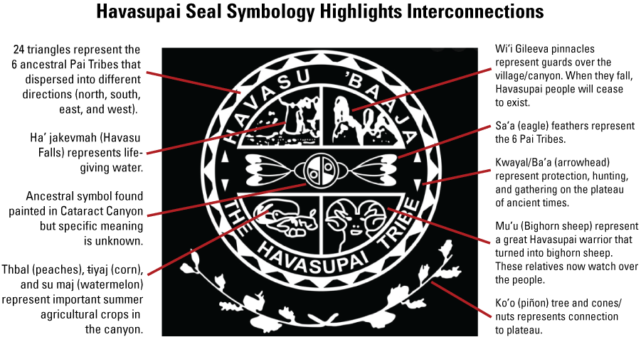
The Havasupai seal with descriptions of components and their meaning. Havasupai nomenclature is also provided. (Edmond Tilousi, Havasupai Tribe, oral commun., June 16, 2022).
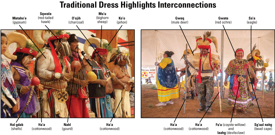
Traditional and ceremonial Havasupai dress shows connections to animal relatives and other resources from Mother Earth. Havasupai nomenclature is also provided. Photographs by Erin Owensby, Williams-Grand Canyon News; and Blake McCord.
For more information about this publication, contact:
Associate Director, Natural Hazards Mission Area
12201 Sunrise Valley Drive
Reston, VA 20192
703–648–5953
For additional information, visit: https://www.usgs.gov/mission-areas/natural-hazards
Publishing support provided by the
Rolla Publishing Service Center
Disclaimers
Any use of trade, firm, or product names is for descriptive purposes only and does not imply endorsement by the U.S. Government.
Although this information product, for the most part, is in the public domain, it also may contain copyrighted materials as noted in the text. Permission to reproduce copyrighted items must be secured from the copyright owner.
Suggested Citation
Tilousi, C., and Hinck, J.E., 2024, Expanded conceptual risk framework for uranium mining in Grand Canyon watershed—Inclusion of the Havasupai Tribe perspective (ver. 1.1, February 2024): U.S. Geological Survey Open-File Report 2023–1092, 25 p., https://doi.org/10.3133/ofr20231092.
ISSN: 2331-1258 (online)
ISSN: 0196-1497 (print)
Study Area
| Publication type | Report |
|---|---|
| Publication Subtype | USGS Numbered Series |
| Title | Expanded conceptual risk framework for uranium mining in Grand Canyon watershed—Inclusion of the Havasupai Tribe perspective |
| Series title | Open-File Report |
| Series number | 2023-1092 |
| DOI | 10.3133/ofr20231092 |
| Edition | Version 1.0: January 30, 2024; Version 1.1: February 1, 2024 |
| Publication Date | January 30, 2024 |
| Year Published | 2024 |
| Language | English |
| Publisher | U.S. Geological Survey |
| Publisher location | Reston, VA |
| Contributing office(s) | Office of the AD Hazards |
| Description | vi, 25 p. |
| Country | United States |
| Online Only (Y/N) | N |
| Additional Online Files (Y/N) | N |