

Hydrogeologic Framework and Considerations for Drilling and Grouting of Closed-Loop Geothermal Bores in the Erie-Ontario Lowlands and Allegheny Plateau of New York State
Links
- Document: Report (3.94 MB pdf) , HTML , XML
- NGMDB Index Page: National Geologic Map Database Index Page (html)
- Download citation as: RIS | Dublin Core
Acknowledgments
The authors thank Carrie Friello, Beth Guidetti, and Brian Slater of the New York State Department of Environmental Conservation (NYSDEC) for their insightful review comments on the draft report. We are grateful to Kevin Moravec of Barney Moravec, Inc., for sharing knowledge concerning water-well and geothermal-bore installation in central and western New York. The discussions with Kevin inspired the authors to prepare this report.
Abstract
The hydrogeologic framework at closed-loop geothermal sites in the Erie-Ontario Lowlands and Allegheny Plateau of central and western New York is the result of the complex interaction of bedrock geology, glacial geology, and groundwater hydrology, and the occurrence of petroleum and gas. Considerations for closed-loop geothermal bore installation include the thickness and character of glacial deposits, bedrock solubility and depth to competent rock, karst development, the distribution of highly permeable zones and their hydraulic heads, and the presence of saline water, gas, and oil. The hydrogeology of the Erie-Ontario Lowlands and Allegheny Plateau poses challenges to closed-loop geothermal bore drilling and casing; managing drill cuttings, discharge water, and gas; and grouting. The potential to encounter severe challenges typically increases with bore depth. This report highlights hydrogeologic considerations for closed-loop geothermal bore installation in New York’s Erie-Ontario Lowlands and Allegheny Plateau to help guide the efficient and safe development of geothermal resources in the regions.
Introduction
Thousands of closed-loop geothermal (CLG) bores and hundreds of thousands of drinking-water wells have been drilled across upstate New York, almost all of them completed in bedrock at depths of less than 500 feet (ft) below land surface (bls). Changes in geothermal bore permitting requirements in 2023–24 (New York State Department of Environmental Conservation, 2024) indicate that, in the future, many CLG bores in New York State will be drilled deeper than 500 ft bls. Those drilling and grouting deeper CLG bores in the lowland and valley settings of central and western New York will need to consider a bore installation that is adjusted to the subsurface conditions and mitigation measures to ensure that water resources are protected.
Development of geothermal energy through vertical closed-loop technology involves the drilling of one to several hundred bores at a given site (International Ground Source Heat Pump Association, 2017) (fig. 1). After drilling, a loop of tubing used to convey the thermal exchange fluid is installed within the total length of the bore. The bore is then grouted from the bore’s total depth to near the land surface (fig. 2). The grout (typically a slurry of bentonite, sand, and graphite) is emplaced to seal the bore and provides the thermal connection between the tubing and surrounding rock formation. Bore drilling and grouting typically is a major cost of installing a CLG system.
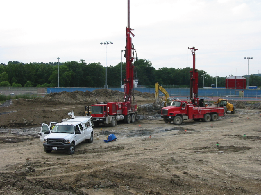
Photograph showing drilling rigs completing bores at the Owego-Apalachin Elementary School geothermal field, Tioga County, New York. Photograph by John H. Williams, U.S. Geological Survey.
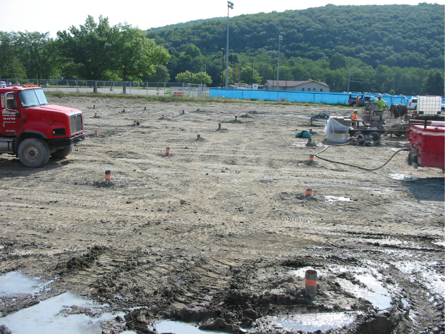
Photograph showing grouting of completed bores following installation of closed-loop tubing at the Owego-Apalachin Elementary School geothermal field, Tioga County, New York. Photograph by William M. Kappel, U.S. Geological Survey.
Because of its diverse physical geography and underlying glacial and bedrock geology, New York State has some of the most varied hydrogeology in the Nation. The hydrogeologic framework of the Erie-Ontario Lowlands and Allegheny Plateau in central and western New York (fig. 3) poses multiple challenges to drilling and grouting bores, and the potential to encounter severe challenges typically increases with bore depth.
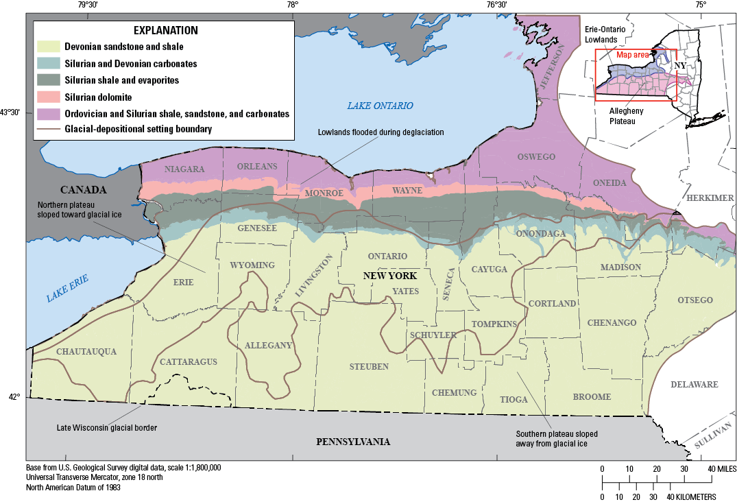
Map of generalized bedrock and glacial geology of the Erie-Ontario Lowlands and Allegheny Plateau of New York State (modified from Fisher and others, 1970; Isachsen and others, 2000; and Randall, 2001).
This overview highlights the importance of considering the hydrogeologic framework, including bedrock geology, glacial geology, groundwater hydrology, and the occurrence of petroleum and gas, for the efficient and safe development of geothermal resources in New York’s Erie-Ontario Lowlands and Allegheny Plateau.
Bedrock Geology
The bedrock geology of the Erie-Ontario Lowlands and the Allegheny Plateau is described by Isachsen and others (2000) and summarized here. The Paleozoic sedimentary bedrock underlying the Erie-Ontario Lowlands and Allegheny Plateau consists of east-west-trending belts of progressively younger bedrock units that generally dip to the south at about 35 to 50 ft per mile (fig. 3). Ordovician and Silurian shales, sandstones, and carbonates underlie the northern lowlands belt along the shores of Lake Ontario. The Ordovician and Silurian bedrock units include the Trenton-Black River dolostone and limestone; Utica black organic-rich shale; Oswego-Queenston-Medina shale and sandstone; and Clinton limestone, dolostone, shale, and sandstone, and ironstone. The Silurian Lockport dolostone underlies the middle belt in the lowlands. The resistant Lockport forms a long cliff-like feature called an escarpment. The Silurian Salina bedrock (including Vernon, Syracuse, and Camillus shale, halite, and gypsum) underlie the southern lowlands belt.
The northern border of the Allegheny Plateau is underlain by Silurian and Devonian carbonates, including the Akron dolostone, Helderberg limestone and dolostone, and Onondaga limestone (Isachsen and others, 2000). The Onondaga and other resistant carbonates form an escarpment. The Helderberg carbonate unit is only in the eastern part of the Allegheny Plateau. The Devonian Hamilton shale and Tully limestone crop out south of the Onondaga escarpment. The lower part of the Hamilton is the Marcellus black organic-rich shale. Farther south, the Allegheny Plateau is underlain by Genesee, Sonyea, West Falls, and Canadaway shales and sandstones. Black organic-rich shales are in the Sonyea, West Falls, and Canadaway units.
The bedrock in the Erie-Ontario Lowlands and Allegheny Plateau shows systematic sets of nearly vertical fractures or joints (Isachsen and others, 2000). Subhorizontal fractures are also present as separations along bedding planes. Bedding-plane fractures generally are more open and extensive in the harder rock units (sandstones and carbonates) than the softer shale units. Extensive fracturing and weathering in the upper 5 to 15 ft of bedrock is common.
Fractures in carbonate rocks may be widened by solutioning, a natural dissolution of soluble rock. Substantial solutioning forms landscape known as “karst” that is characterized by features such as sinkholes, swallets, and caves. Limestone is more soluble than dolostone, and the Helderberg carbonate unit in the eastern part of the Allegheny Plateau has the most well-developed karst (Kappel and others, 2020). The Onondaga carbonates in central and western parts of the Allegheny Plateau has karst features, including large-closed depressions, early cave development, and sinkhole-related subsidence, especially near its escarpment. Karst features are present in the Ordovician and Silurian dolostones but are less well developed.
In the Salina shale and evaporite units, nearly all halite and much of the gypsum has been removed by solutioning in their outcrop area and for some distance downdip to the south. The removal of soluble halite and gypsum results in localized solution cavities in the shales. The shales are structurally weak and commonly collapse, resulting in partial filling of the cavities with overlying shale and additional fracturing of the shales above (Crain, 1974).
Where not removed by natural solutioning processes, Salina evaporites have been mined in parts of Ontario, Monroe, Genesee, and Erie Counties (Isachsen and others, 2000). Gypsum was mined by the room-and-pillar method at depths of 30 to 70 ft bls, which locally has resulted in fracturing of overlying bedrock and surface subsidence. Halite has been room-and-pillar or solution mined at depths of greater than 1,000 ft bls in parts of Onondaga, Tompkins, Schuyler, Livingston, and Wyoming Counties, which locally has resulted in fracturing of overlying bedrock and, in certain areas, surface subsidence.
Glacial Geology
The glacial geology of the Erie-Ontario Lowlands and the Allegheny Plateau is described by Randall (2001) and summarized here. The region is north of the Late Wisconsin glacial border except for southernmost Cattaraugus County (fig. 3). The glacial sediments or drift include till (unstratified mixture of clay, silt, sand, and boulders) deposited directly on or under the ice, stratified fines (fine sand, silt, and clay) deposited in proglacial lakes, and stratified sand and gravel deposited by glacial meltwaters.
The Erie-Ontario Lowlands were flooded during deglaciation and are underlain by extensive stratified fines (fig. 3). Stratified sand and gravel deposits are sparse and are typically buried within and below stratified fines. Drift thickness is generally less than 100 ft. Till accumulated as drumlins and similar elliptical hills composed partly of bedrock but were reshaped by moving glacial ice. Extensive wetland areas in the lowlands are underlain by muck.
In upland areas of the Allegheny Plateau, till covers bedrock except on steep slopes and hilltops where bedrock crops out. The upland tills are generally less than 25 ft thick but may be as much as 250 ft thick in “till shadows” on south-facing slopes (Coates, 1966). In the northern part of the Allegheny Plateau where the land surface generally sloped toward the glacial ice, the major valleys are filled with multiple drift sheets consisting of interlayered till and stratified fines with minor sand and gravel that are as much as 500 ft thick. In the southern part of the Allegheny Plateau where the land surface generally sloped away from the glacial ice, widely spaced valleys are filled with 100 to 500 ft of drift (fig. 3) with increased thicknesses of stratified fines with greater depths to bedrock. Deposits of sand and gravel are found below stratified fines and above bedrock in many valleys. Outwash, floodplain alluvium, and alluvial-fan deposits form extensive surficial sediments on the valley floors.
Groundwater Hydrology
Permeability in the glacial deposits of the Erie-Ontario Lowlands and Allegheny Plateau is directly related to the sediment grain size and sorting of the deposit (Waller, 1988). Saturated sand and gravel deposits form highly transmissive aquifers, whereas stratified fines and till form confining units, which impede the flow of groundwater. Permeability of the bedrock is related to fractures within the bedrock. The permeability of fractures varies on the basis of their size and connection with other fractures within the rock mass. Permeability is enhanced by solutioning along fractures in carbonate bedrock (Kappel and others, 2020). Karstic limestone units have the highest transmissivity. Sandstones generally are more transmissive than the softer shales. The exception to this generalization is the Salina units, in which permeability locally is greatly enhanced by solutioning of evaporites within and between shale beds.
Hydraulic head is the product of local and subregional topographic relief, distribution and permeability of aquifer and confining zones, and position in the groundwater flow system. In the fresh groundwater flow system, hydraulic head generally decreases with depth in upland recharge areas and increases with depth in valley-floor discharge areas. Multiple aquifers may be present in the valley fill including a surficial unconfined (water table) aquifer and one or more confined (artesian) aquifers (Randall, 2001). Basal confined sand-and-gravel aquifers are present and in hydraulic contact with the fractured top of bedrock in many valleys.
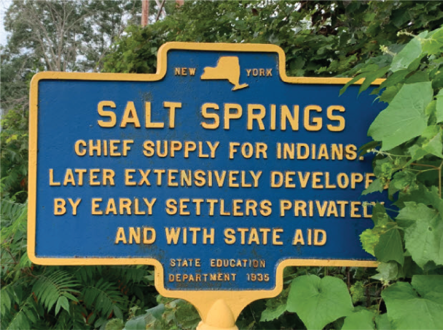
Freshwater flow systems overlie saline water throughout the Erie-Ontario Lowlands and Allegheny Plateau. Active fresh groundwater flow systems are generally viewed as having been flushed of pre-existing connate water (Heisig and Scott, 2013). Saline water, in some places, is present in confined sand and gravel zones above bedrock, but typically the transition from fresh to saline water occurs within the bedrock. Saline water generally is found at shallower depths in the Erie-Ontario Lowlands than in the Allegheny Plateau. An example of shallow saline water in the Erie-Ontario Lowlands is Salt Spring in Cayuga County (fig. 4). Water-well drillers commonly do not drill more than 50 ft into bedrock in the lowlands to avoid saline water (Griswold, 1951; Frimpter, 1974). A 370-ft deep well in Wayne County completed in the Salina bedrock produced 600 gallons per minute of saline water with a chloride concentration of 21,000 milligrams per liter (Reynolds and others, 2022). Ferrous-sulfide rich water or “black water,” which is highly corrosive, is locally present below the depth of freshwater circulation in the Salina and Lockport units in the western part of the Erie-Ontario Lowlands (Kappel and Jennings, 2012).
Photograph of historical maker for Salt Springs in Cayuga County, New York, September 21, 2021. Photograph by Steve Stossel, HMdb.org.
In the Allegheny Plateau, the transition between fresh and saline water occurs as shallow as 200 ft bls in the valleys and as deep as 800 ft bls in the uplands (Williams, 2010). In a major river valley in south-central Tioga County, multiple bores drilled for a large geothermal field penetrated a bedding-related fracture zone at depths of 240 to 260 ft bls in Devonian sandstone and shale confined by stratified fines that produced water with chloride concentrations as high as 24,000 milligrams per liter (Williams and Kappel, 2015).
Petroleum and Gas Occurrence
The upper Devonian Canadaway and West Falls units underlying the southern half of Steuben, Allegany, Cattaraugus, and Chautauqua Counties contain oil that is stratigraphically trapped in shallow permeable sandstone lenses (Isachsen and others, 2000). The depth to the oil-bearing sandstones is more than 1,000 ft bls in the uplands but is less than 500 ft bls in some valley-floor areas. Brines associated with the oil fields in these counties are as shallow as 300 ft bls (Griswold, 1951).
Methane gas locally occurs in bedrock below the freshwater/saline-water transition throughout the Erie-Ontario Lowlands and Allegheny Plateau. As indicated by surface seeps (for example, those at Burning Springs in Ontario County), methane occurs at very shallow depths in the lowlands along Lake Erie and Ontario (Kappel and Nystrom, 2012) (fig. 5). The first commercial gas well was drilled to less than 30 ft bls into upper Devonian black shale in Chautauqua County. Methane has been commercially produced from the Trenton and Black River carbonates in the eastern Ontario lowlands and from the Medina sandstones in the southeastern Erie-Ontario Lowlands and Allegheny Plateau from depths as shallow as 450 to 1,000 ft bls (Isachsen and others, 2000).
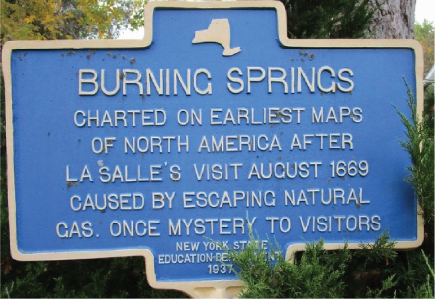
Photograph of historical marker for Burning Springs in Ontario County, New York, October 26, 2018. Photograph by Anton Schwarzmueller, HMdb.org.
In south-central New York, one-third of domestic water wells sampled by Heisig and Scott (2013) in valley settings that were completed in Devonian bedrock confined by stratified fines or till had methane concentrations of 28 milligrams per liter or greater, which is the solubility of methane at atmospheric pressure and considered an explosivity hazard (Eltschlager and others, 2001). In the geothermal field in Tioga County, about half of the 495-ft-deep bores reportedly discharged methane gas to land surface when drilled (Williams and Kappel, 2015).
Hydrogen sulfide is a corrosive gas that smells like rotten eggs and is produced from decomposition of organic matter in an acidic reducing environment. This gas is locally associated with “black water.”
Considerations for Bore Drilling and Grouting
Glacial deposits overlying bedrock typically need to be cased during drilling of CLG bores. If the depth to bedrock is shallow, the casing may be removed during grouting of the bore; however, if the glacial deposits are thick, recovering the casing is not practical, and it is left in place. Boulders in till and flowing fine sands or “quicksand” in proglacial-lake deposits can cause drilling and casing installation problems (Sterrett, 2007).
In sandstone, dolostone, and most shales, competent rock typically is within 20 ft of the contact between the glacial drift and bedrock, and the amount of additional needed casing is minimal. However, because of their solubility, the depth to competent rock in the Salina shales and evaporites may be substantially deeper than their contact with the overlying glacial drift and may require substantially more casing. Tunnel voids and overlying incompetent rock are to be expected in areas in which gypsum has been mined from the Salina units.
Substantial voids may be penetrated at depth during drilling of the Helderberg and Onondaga carbonates. Such karst-related openings can result in lost circulation and may need to be cased during drilling. If not cased, the voids require additional amounts of grout (Sterrett, 2007). Chert layers in the Onondaga limestone cause excessive abrasive wear on drilling bits and may damage closed-loop tubing during insertion.
Penetration of highly permeable sand-and-gravel aquifers and bedrock-fractured zones may cause difficulties in drilling that require additional casing. Highly permeable zones can accept drilling fluids and cause lost circulation of drill cuttings. Conversely, large amounts of surface discharge produced from the permeable zones during air-hammer drilling may result in excessive bore-flow velocities and cause drilling difficulties. Large-diameter bores may be needed to handle high-velocity flows if permeable zones are not cased. Additionally, if not cased, these zones might accept excessive amounts of grout.
In valley and lowland settings, flowing-artesian conditions (pressurized water under a confining unit) may be penetrated in sand and gravel aquifers and bedrock-fractured zones. Without properly installed casing, the artesian-pressured water may flow up along the outside of the casing and breach at the land surface, creating an uncontrolled discharge. These conditions are difficult to control during drilling and adversely affect the grouting process.
Installation of the closed-loop tubing into a bore with flowing-artesian conditions to total depth and keeping the grout in place in the bore can be a challenge. Also, unless a quick-setting grout is used, the artesian flow may “pipe” its way through a standard slower-setting grout, making for an inefficient seal and thermal connection and possibly allowing flowing conditions within the bore or at land surface.
Penetration of saline-water bearing zones during drilling can discharge saline water to the surface and affect shallow groundwater quality. The issue is exacerbated if flowing-artesian conditions are penetrated or if the saline water contains some oil. Waters can be contained onsite in tanks for proper disposal, which may require permitting. Saline-water discharge during drilling of the major geothermal field in south-central Tioga County was contained in onsite tanks (Williams and Kappel, 2015). The amount of saline-water discharge produced during drilling was minimized by using a sleeve of pipe with rubber packers at both ends to span and help seal the fracture zone. The presence of saline water can substantially affect grouting of CLG bores and may require specially formulated grouts to provide an effective seal and thermal connection.
Drill cuttings and drilling discharge water from CLG bores that are tainted with petroleum pose a challenge because they need to be properly contained and disposed of to protect surface-water and groundwater resources. Careful monitoring for natural gas during drilling of CLG bores is important because methane is flammable and not easily detected. There have been several reports of drilling rigs catching fire because they penetrated methane-producing zones while drilling water wells and geothermal bores (Williams and Kappel, 2015).
Drilling operations can negatively affect nearby residential and public water-supply wells without proper planning to identify and mitigate potential effects. Information on well location and construction can be used to assess potential effects. The most common effects associated with drilling are temporary turbidity issues during the drilling operation. However, drilling can negatively affect other aspects of water quality. Hydrogen sulfide gas is also a safety concern, particularly when produced at high volumes, because it is heavier than air and collects in low-lying and confined spaces. In addition, gas can affect grout integrity because it can pipe up through grout before setting up and may require the use of quick-setting grout. Hydrogen sulfide gas may also affect grout integrity because of chemical reactions.
Summary
This report presents an overview of the hydrogeologic framework and considerations for drilling and grouting of closed-loop geothermal (CLG) bores in the Erie-Ontario Lowlands and Allegheny Plateau of central and western New York. The hydrogeologic framework at CLG sites in the Erie-Ontario Lowlands and Allegheny Plateau is the result of the complex interaction of bedrock geology, glacial geology, and groundwater hydrology, and the occurrence of petroleum and gas. Considerations for CLG bore installation include the thickness and character of glacial deposits, bedrock solubility and depth to competent rock, karst development, the distribution of highly permeable zones and their hydraulic heads, and the presence of saline water, gas, and oil. The hydrogeology of the Erie-Ontario Lowlands and Allegheny Plateau poses challenges to CLG bore drilling and casing; managing drill cuttings, discharge water, and gas; and grouting. The potential to encounter severe challenges typically increases with bore depth.
Changes in geothermal bore permitting requirements in 2023–24 indicate that, in the future, many CLG bores in New York State will be drilled deeper than 500 feet below land surface. Although thousands of CLG bores and hundreds of thousands of drinking-water wells have been drilled across upstate New York, almost all of them were completed in bedrock at depths of less than 500 feet below land surface. Installation of deeper CLG bores in the lowland and valley settings of central and western New York will require proper planning and bore installation that is adjusted to the subsurface conditions with mitigation measures to ensure that water resources are protected.
This report highlights hydrogeologic considerations for CLG bore installation in New York’s Erie-Ontario Lowlands and Allegheny Plateau to help guide the efficient and safe development of geothermal resources in the regions.
Links for Additional Information
-
Archived U.S. Geological Survey and New York State Department of Environmental Conservation county and basin water resource reports: https://archive.org/details/usgswaterresourcesnewyork
-
New York State Department of Environmental Conservation DECinfo Locator: https://www.dec.ny.gov/pubs/109457.html
-
New York State Department of Environmental Conservation Supplemental Generic Environmental Impact Statement—Chapter 4, Geology: https://extapps.dec.ny.gov/docs/materials_minerals_pdf/fsgeis2015ch4.pdf
-
New York State Museum Geology: https://www.nysm.nysed.gov/research-collections/geology
-
U.S. Geological Survey Upstate New York Aquifer Viewer (version 2.0): https://experience.arcgis.com/experience/c25203b9f3dd439e9f2a180f6d743ec3
References Cited
Coates, D.R., 1966, Glaciated Appalachian Plateau—Till shadows on hills: Science, v. 152, no. 3729, p. 1617–1619, accessed November 14, 2024, at https://doi.org/10.1126/science.152.3729.1617.
Eltschlager, K.K., Hawkins, J.W., Ehler, W.C., and Baldassare, F., 2001, Technical measures for the investigation and mitigation of fugitive methane hazards in areas of coal mining: U.S. Department of the Interior, Office of Surface Mining Reclamation and Enforcement, 125 p., accessed November 14, 2024, at http://www.techtransfer.osmre.gov/NTTMainSite/Library/hbmanual/methane/methane.pdf.
Fisher, D.W., Isachsen, Y.W., and Rickard, L.V., 1970, Geologic map of New York: New York State Museum and Science Service Map and Chart Series No. 15, 5 sheets, scale 1:250,000, accessed November 14, 2024, at https://www.nysm.nysed.gov/sites/default/files/mc15_geologicmapofnewyork.pdf.
Heisig, P.M., and Scott, T.-M., 2013, Occurrence of methane in groundwater of south-central New York State, 2012—Systematic evaluation of a glaciated region by hydrogeologic setting: U.S. Geological Survey Scientific Investigations Report 2013–5190, 32 p., 4 app., accessed November 14, 2024, at https://doi.org/10.3133/sir20135190.
International Ground Source Heat Pump Association, 2017, Closed-loop/geothermal heat pump systems—Design and installation standards (2017 ed.): Stillwater, Okla., International Ground Source Heat Pump Association, [variously paged; 39 p.], accessed March 12, 2025, at https://igshpa.org/wp-content/uploads/2017-IGSHPA-Standards-restricted.pdf.
Isachsen, Y.W., Landing, E., Lauber, J.M., Rickard, L.V., and Rodgers, W.B., 2000, Geology of New York—A simplified account (2d ed.): New York State Museum Educational Leaflet 28, p. 23–44, accessed November 14, 2024, at https://www.researchgate.net/publication/275652938_Geology_of_New_York_A_Simplified_Account_Second_Edition.
Kappel, W.M., and Jennings, M.B., 2012, Water resources of the Iroquois National Wildlife Refuge, Genesee and Orleans counties, New York, 2009–2010: U.S. Geological Survey Scientific Investigations Report 2012–5027, 53 p., accessed November 14, 2024, at https://doi.org/10.3133/sir20125027.
Kappel, W.M., and Nystrom, E.A., 2012, Dissolved methane in New York groundwater, 1999–2011: U.S. Geological Survey Open-File Report 2012–1162, 6 p., accessed November 14, 2024, at https://doi.org/10.3133/ofr20121162.
Kappel, W.M., Reddy, J.E., and Root, J.C., 2020, Statewide assessment of karst aquifers in New York with an inventory of closed-depression and focused-recharge features: U.S. Geological Survey Scientific Investigations Report 2020–5030, 74 p., accessed November 14, 2024, at https://doi.org/10.3133/sir20205030.
New York State Department of Environmental Conservation, 2024, Geothermal wells deeper than 500 feet: New York State Department of Environmental Conservation web page, accessed November 14, 2024, at https://dec.ny.gov/environmental-protection/oil-gas/well-owner-and-applicants-information-center/regulated-well-types/geothermal-wells-deeper-than-500 -feet#:~:text=The%20Division%20of%20Mineral%20Resources%20regulates%20the%20drilling%2C,of%20the%20Oil%2.
Randall, A.D., 2001, Hydrogeologic framework of stratified drift aquifers in the glaciated northeastern United States: U.S. Geological Survey Professional Paper 1415–B, 179 p., 1 pl., scale 1:2,500,000. [Also available at https://doi.org/10.3133/pp1415B.]
Reynolds, R.J., Heisig, P.M., and Linsey, K.S., 2022, Hydrogeology of aquifers within the Fairport-Lyons channel system and adjacent areas in Wayne, Ontario, and Seneca Counties, New York: U.S. Geological Survey Scientific Investigations Report 2021–5086, 15 p., 2 pls., scale 1:24,000, accessed November 14, 2024, at https://doi.org/10.3133/sir20215086.
Waller, R.M., 1988, Ground water and the rural homeowner: U.S. Geological Survey General Information Product, 38 p., accessed April 1, 2025, at https://pubs.usgs.gov/gip/gw_ruralhomeowner/pdf/gw_ruralhomeowner.pdf.
Williams, J.H., 2010, Evaluation of well logs for determining the presence of freshwater, saltwater, and gas above the Marcellus Shale in Chemung, Tioga, and Broome Counties, New York: U.S. Geological Survey Scientific Investigations Report 2010–5224, 27 p., accessed November 14, 2024, at https://doi.org/10.3133/sir20105224.
Williams, J.H., and Kappel, W.M., 2015, Hydrogeology of the Owego-Apalachin Elementary School geothermal fields, Tioga County, New York: U.S. Geological Survey Scientific Investigations Report 2015–5155, 29 p., accessed November 14, 2024, at https://doi.org/10.3133/sir20155155.
For more information about this report, contact:
Director, New York Water Science Center
U.S. Geological Survey
425 Jordan Road
Troy, NY 12180–8349
dc_ny@usgs.gov
or visit our website at
https://www.usgs.gov/centers/new-york-water-science-center
Publishing support provided by the Pembroke Publishing Service Center
Disclaimers
Any use of trade, firm, or product names is for descriptive purposes only and does not imply endorsement by the U.S. Government.
Although this information product, for the most part, is in the public domain, it also may contain copyrighted materials as noted in the text. Permission to reproduce copyrighted items must be secured from the copyright owner.
Suggested Citation
Williams, J.H., Kappel, W.M., and Woda, J.C., 2025, Hydrogeologic framework and considerations for drilling and grouting of closed-loop geothermal bores in the Erie-Ontario Lowlands and Allegheny Plateau of New York State: U.S. Geological Survey Open-File Report 2025–1013, 11 p., https://doi.org/10.3133/ofr20251013.
ISSN: 2331-1258 (online)
Study Area
| Publication type | Report |
|---|---|
| Publication Subtype | USGS Numbered Series |
| Title | Hydrogeologic framework and considerations for drilling and grouting of closed-loop geothermal bores in the Erie-Ontario Lowlands and Allegheny Plateau of New York State |
| Series title | Open-File Report |
| Series number | 2025-1013 |
| DOI | 10.3133/ofr20251013 |
| Publication Date | April 22, 2025 |
| Year Published | 2025 |
| Language | English |
| Publisher | U.S. Geological Survey |
| Publisher location | Reston, VA |
| Contributing office(s) | New York Water Science Center |
| Description | v, 11 p. |
| Country | United States |
| State | New York |
| Other Geospatial | Allegheny Plateau, Erie-Ontario Lowlands |
| Online Only (Y/N) | Y |
| Additional Online Files (Y/N) | N |