

Preliminary Field Report of Landslide Hazards Following Hurricane Helene
Links
- Document: Report (7.42 MB pdf) , HTML , XML
- Data Release: USGS data release - Oblique Aerial Photographs from October 13 and 17, 2024, of Landslides and Flooding Caused by Hurricane Helene (ver 1.1, March 2025)
- NGMDB Index Page: National Geologic Map Database Index Page (html)
- Download citation as: RIS | Dublin Core
Acknowledgments
Material in this report was originally prepared by the authors of this report for the Federal Emergency Management Agency (FEMA) under mission assignment DR-4827-NC. Many of the report’s findings and conclusions are founded on a basis of the collective efforts of the 30 plus members of the U.S. Geological Survey’s (USGS) Landslide Assessments, Situational Awareness, and Event Response Research (LASER) team and its interagency partners (State geological surveys, emergency managers, and academic and industry partners) during the broader Hurricane Helene landslide response. Partners include the North Carolina Geological Survey, Tennessee Geological Survey, Virginia Department of Energy Geology and Mineral Resources, Kentucky Geological Survey, National Weather Service, National Aeronautics and Space Administration, National Park Service, U.S. Department of Agriculture Forest Service, Appalachian Landslide Consultants PLLC, Geotechnical Extreme Events Reconnaissance Association, Center for Land and Surface Hazards, and BGC Engineering. The authors especially acknowledge Lauren Schaefer (USGS), who led the USGS LASER landslide response and thank Jenny Riker (USGS), Alice Pennaz (USGS), and Andrew Graber (USGS) for providing reviews that significantly improved the manuscript.
Executive Summary
This report reflects our knowledge regarding the widespread landslide activity associated with Hurricane Helene observed during the U.S. Geological Survey’s (USGS) mission assignment to North Carolina in October 2024. The material in this report was originally prepared for the Federal Emergency Management Agency under mission assignment DR-4827-NC. The data and commentary in this report are reflective of a report provided to the Federal Emergency Management Agency (FEMA) on October 18, 2024, as well as information provided in briefings at the Buncombe County Emergency Operations Center. The report has been modified for public dissemination.
This assessment was based on systematic visual examination and mapping of landslide locations from aerial and satellite imagery, visual and photographic observations from low-level helicopter overflights and conversations with local landslide experts from the North Carolina Geological Survey and Appalachian Landslide Consultants PLLC, and more than 50 years of combined landslide hazard professional experience of the mission-assigned field team. No systematic field investigations were done by the USGS.
While responding to the event, the USGS did not identify any landslides that posed an immediate major threat to recovery personnel in parts of nine counties in North Carolina (Avery, Buncombe, Henderson, McDowell, Mitchell, Polk, Rutherford, Watauga, and Yancey); however, threats from renewed landslide activity may remain heightened in localized areas for months or even years. Known areas of the most abundant landslide occurrence include Bat Cave, Lake Lure, Chimney Rock, Swannanoa, Black Mountain, Fairview, steep areas in Asheville, and the Blue Ridge Parkway. The USGS shared detailed locations of known landslides with the Emergency Operations Centers. The thousands of landslide scars on hillsides and landslide deposits on flatter ground may present some threat to recovery activities. Soil and rocks will continue to erode from newly exposed landslide scars and may pose a threat to people and infrastructure who are immediately nearby. In general, the steeper and taller the landslide scar, the greater the potential threat. This threat is heightened during periods of rainfall and increases with the duration and intensity of rainstorms. Very heavy rainfall, or repeated rainfall events during short periods, could also initiate new landslides on steep slopes. Excavation of landslide deposits, particularly excavation of those deposits directly adjacent to steep slopes, may also pose a threat to nearby people and equipment.
An interagency collaborative mapping effort led by the USGS that informed this assessment identified 1,155 landslide locations by the October 2024 briefings, but that number increased to 2,217 in a final reviewed version of the locations published in January 2025. Locations were mapped from satellite imagery, fixed-wing and helicopter surveys, media and social media, and field reports in the 3 weeks following the passage of the remnants of Hurricane Helene. USGS products outlined in this report are publicly available and include geotagged photographs from aerial reconnaissance, hazard models, an interactive view of mapped landslide locations, and landslide safety and education resources.
Introduction
Hurricane Helene made landfall in Florida late on September 26, 2024, and continued northward across the southern Appalachian region (North Carolina, Tennessee, Virginia, and South Carolina) in the early morning of September 27, 2024, producing record rainfall. The soils in the region were already saturated by preceding rainfall, including a 2-day predecessor rain event. The maximum 72-hour rainfall total (from 1200 coordinated universal time [UTC] on September 25, 2024, to 1200 UTC on September 28, 2024) measured in western North Carolina, including the predecessor rain event and Hurricane Helene, was 30.8 inches (National Weather Service, 2024). This series of storms unleashed widespread and destructive flooding, landslides, and damaging winds across the region.
In response to Hurricane Helene, on September 28, 2024, the U.S. Geological Survey (USGS) Geological Hazards Science Center activated its Landslide Assessments, Situational Awareness, and Event Response Research (LASER) team (Allstadt and others, 2024b; USGS 2024d) to support early requests for assistance from the North Carolina Geological Survey (NCGS) and Tennessee Geological Survey (Schaefer and others, 2024). The USGS LASER team coordinated a rapid interagency response effort composed of 38 USGS personnel and 14 personnel from nine partner agencies. During the next 4 weeks, the team facilitated interagency coordination calls; provided rapid hazard models (Martinez and others, 2024); conducted early aerial fixed-wing reconnaissance on October 3–5 (Rengers and Mirus, 2024; fig. 1); coordinated multiagency field reconnaissance; and coordinated a multiagency effort to map landslide locations and effects as remote sensing imagery, field reports, media and social media reports became available (fig. 1; Burgi and others, 2024, 2025). To make information publicly available and respond to agencies as quickly as possible, a dashboard of these mapped landslide locations (USGS, 2024c) and an accompanying ArcGIS web service were updated in realtime as new locations were mapped. The team also handled media requests, generated informational web pages (USGS, 2024b), safety information, and social media posts (for example, USGS, 2024a, f20), and shared critical information and assessments with emergency responders through daily situational reports.
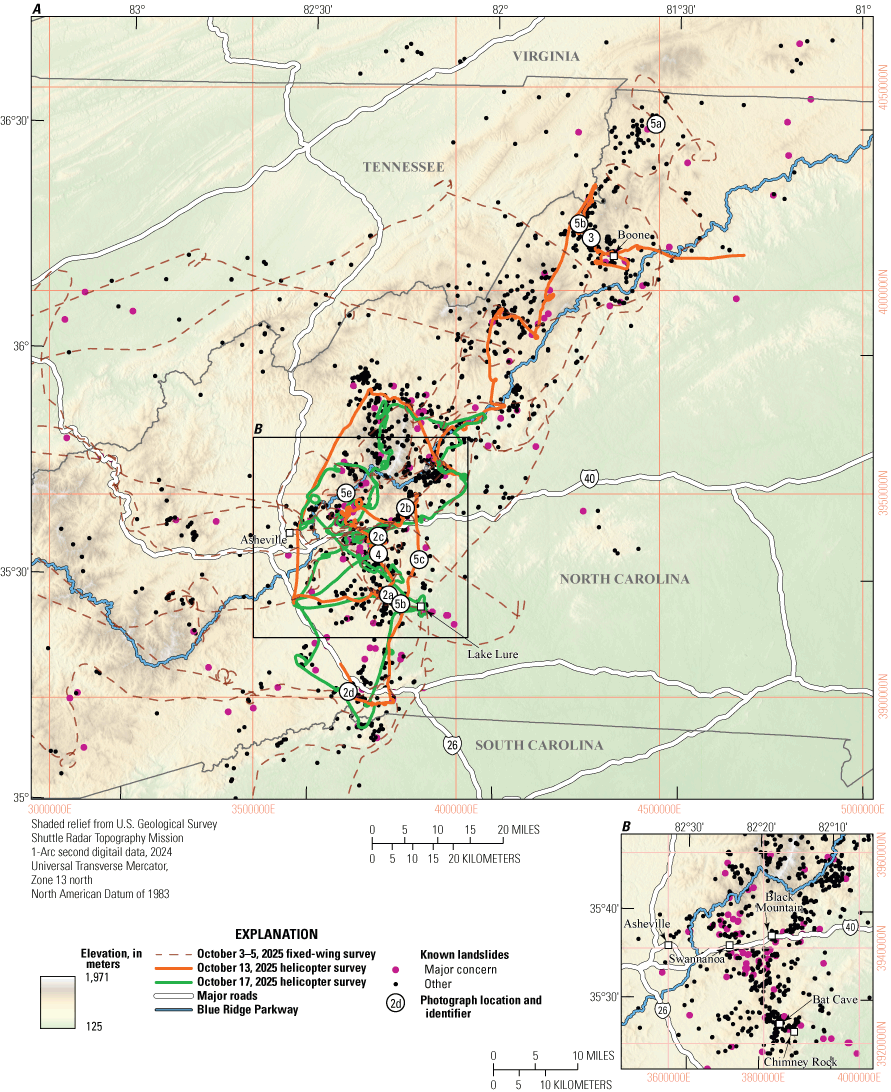
A–B, Elevation map showing an overview of landslides triggered by Hurricane Helene in western North Carolina, northern South Carolina, eastern Tennessee, and parts of southern Virginia. Landslide locations shown are those that were mapped by the U.S. Geological Survey and partner agencies by the end of the rapid response mapping effort on October 23, 2024. Known landslides labeled as “major concern” because of potential fatalities, injuries, rescue, or evacuation needs are indicated by pink points. Inventory is overlain by aerial reconnaissance flight paths and photograph locations (refer to figs. 2–5).
On October 6, 2024, the USGS received the initial Federal Emergency Management Agency (FEMA) mission assignment statement of work, as follows:
The USGS will provide advance support, real-time analysis, and identification of increased landslide risk from pre-event conditions, including consideration of the consequences for infrastructure in landslide impacted areas. USGS services may include, but are not limited to, the following in direct support of disaster operations:
-
• Assessing landslide occurrence, severity, and scope of impacts from analysis of remote-sensing imagery.
-
• Conducting primary aerial reconnaissance and supplemental ground site visits to further refine landslide areas identified from remote-sensing imagery.
-
• Installing observing equipment to assist in monitoring surface and subterranean soil movement.
-
• Providing technical assistance within landslide-impacted areas to help inform infrastructure stabilization plans to mitigate landslide risk.
-
• Providing guidance and technical assistance as feasible to help define or describe additional mitigation work that could be or may need to be done, and provide language that could be used to generate scoping assessments for future permanent work.
To respond to this mission assignment, the authors of this report (referred to herein as the “field team”) were initially deployed on October 8, 2025, to the North Carolina State Emergency Operations Center (EOC) and then to the field, based out of the Buncombe County EOC, on October 13–25, 2025. The field investigation was centered on nine counties in North Carolina where the most damaging landslides occurred and focused on those counties most affected (for example, Buncombe and Rutherford). However, the USGS LASER team and partners also conducted remote investigations in the six States most affected by Hurricane Helene. These remote investigations also formed a basis for the field team’s assessments. The remainder of this report details the methods and findings of the field team while on mission assignment and emphasizes response and recovery safety and ongoing hazards. Much of the content of this report was initially prepared on October 18, 2024, for FEMA under mission assignment DR-4827-NC. The authors have modified this report for public release to include more background information and to incorporate additional educational materials and briefings provided to FEMA and other emergency personnel during the response. The report also reflects some updated information that was not available at the time of its initial preparation (2024), such as updated landslide counts.
Regarding terminology, this report uses the term “mudflow” to refer collectively to two flow types technically known in the scientific community as (1) debris flows, a type of highly mobile, channelized landslide consisting of water-saturated, poorly sorted sediment (Hungr and others, 2014), and (2) hyperconcentrated flows, which are sediment-rich channelized flows with lower sediment concentrations than debris flows (Beverage and Culbertson, 1964). Debris flows may transition into hyperconcentrated flows (or hyperconcentrated flows into debris flows) and eventually water flows as sediment concentrations change along the path (Pierson, 2005). The authors use the term “mudflow” rather than the proper scientific terms to match the colloquial usage by the media and emergency responders. In addition, the use of the word “debris” in debris flow could potentially cause confusion during an emergency response because the term is used by FEMA to refer to any material that needs to be removed after a disaster as “debris” (for example, demolition debris, vehicle and vessel wreckage, and vegetative debris).
Methods and Data
Building on the information collected by the USGS LASER team and interagency partners described in the “Introduction” section, the mission-assigned field team conducted onsite field observations in coordination with geologists in North Carolina, by helicopter or on the ground, on October 13–24, 2024. Low-altitude helicopter flights were conducted on October 13 and 17, 2024. Geotagged oblique aerial photographs from those flights are now available for download online (Allstadt and others, 2024a), and a subset of representative photographs is viewable in the USGS Hurricane Helene Landslide Photo Viewer (https://arcg.is/00C9X5). The field team’s ground reconnaissance was limited to specific sites requested by the EOC, although the team coordinated closely with partner agencies such as NCGS as they conducted field assessments of significant landslides.
The field team’s reconnaissance plans were based in part on the remote sensing-based mapping conducted by the USGS LASER team and interagency collaborators. Known landslide locations mapped by the end of the rapid mapping effort on October 23, 2024, are shown on figure 1. Ultimately, 112 landslides of major concern because of potential fatalities, injuries, rescue, or evacuation needs (table 1; fig. 1) were shared with emergency managers for situational awareness as soon as they were identified by the USGS LASER team. A list of publicly available USGS resources, datasets, and information products relevant to the Hurricane Helene landslide is available in appendix 1.
Table 1.
Landslide categories, definitions, and total counts identified from Hurricane Helene by the U.S. Geological Survey Landslide Assessments, Situational Awareness, and Event Response Research (LASER) team as of October 23, 2025.Results
Hurricane Helene’s intensive rainfall (combined with a prior frontal storm) caused a substantial number of slopes to fail, triggering landslides, mudflows, and (to a lesser extent) rock falls, affecting the whole region (fig. 1). Storms like Hurricane Helene that trigger thousands of landslides, which are typically also associated with tropical cyclones, reoccur about every 25 years in the southern Appalachian region (Wooten and others, 2016). As far as the authors are aware, the land movement triggered by rainfall from Hurricane Helene may be among the most significant and damaging of those historical weather events. However, by October 18, 2024—the date the field team’s initial findings were reported to FEMA—the team had not observed an ongoing risk of continued land movement that posed an immediate major threat to recovery personnel.
The field team contextualized this preliminary finding with three uncertainties: (1) the risk of ground movement may change with heavy rainfall events, which could remobilize landslides; (2) slope modification activities (for example, digging out debris that cover roads or properties) can heighten the risk of landslides (refer to the “Safety Considerations” section); (3) areas of high landslide risk may not have been observed because remote and aerial reconnaissance was limited by tree and cloud cover in some areas. Though the field team advised of these uncertainties immediately after the storm, they are still applicable at the time of writing this report (March 2025). The collection, processing, and dissemination of postevent Light Detection and Ranging (lidar) data, which could be used to characterize landslides hidden by tree cover, are still underway. Local and State agencies are still conducting ground-based observations that may help reduce uncertainties and provide a more granular understanding of specific areas. The increased susceptibility to landslides in locations destabilized during the storm decreases exponentially with time, but it may still persist and can take as long as 25 years to return to pre-event levels (Samia and others, 2017). NCGS received reports of some ongoing or reactivated slope movement following storms in the winter months following Hurricane Helene.
Most of the landslides the field team observed (for example, fig. 2A–D) were relatively small but numerous and sometimes clustered in high concentrations (fig. 2A). Because of the density of structures in or near steep areas, sometimes even small landslides destroyed or damaged multiple structures (figs. 2, 3). Most damage was caused by the landslide runout, but some structures or roads were undercut by slope failures below the structures or roads. Landslides also indirectly affected communities by damaging or destroying roads and other infrastructure (for example, fig. 2B, D). The combined effects of landslides and flooding severed transportation connectivity across the region.
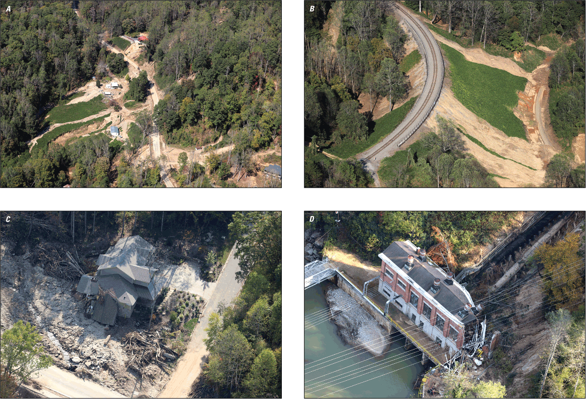
Photographs showing examples of homes and infrastructure affected by landslides and mudflows observed during reconnaissance flights in North Carolina. A, High concentration of impactful landslides in Bat Cave, 35.463°, −82.285°. B, Failures of engineered slope along railroad (left) inundating a lower-elevation section of track (right), 35.656°, −82.242°. C, House damaged by mudflow near Black Mountain, the road has been cleared of debris, 35.593°, −82.316°. D, Hydropower structure damaged by a landslide, 35.248°, −82.391°. Coordinates indicate the approximate location of the photographer (Photographs by S. Slaughter, U.S. Geological Survey).
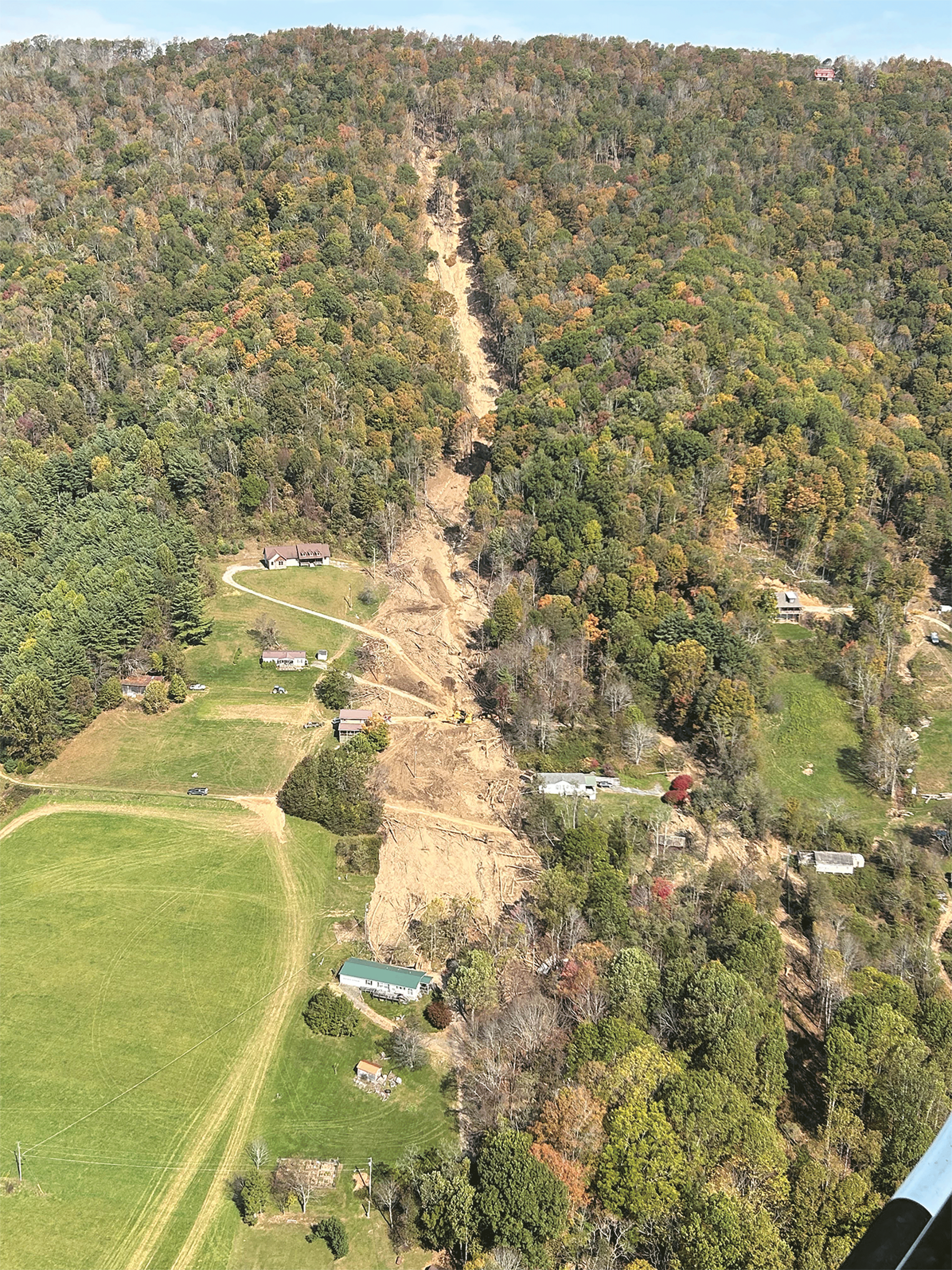
Photograph showing a landslide that transitioned into a mudflow that damaged structures near Boone, North Carolina. Approximate coordinates of the photographer were 36.259°, −81.744° (Photograph by J. Godt, U.S. Geological Survey).
The largest mudflows formed where many smaller landslides converged into channels and incorporated sufficient water and sediment to combine into massive, long runout mudflows. For example, one of the largest and deadliest mudflows originated from at least five coalescing landslide sources that traveled more than 1.5 miles along Flat Creek, where it destroyed a small community known as “Craigtown,” in Fairview, Buncombe County, North Carolina (fig. 4A, B). Thirteen residents were killed; 11 from the same family, and then two responders by a second surge (Medina, 2024). A similarly large mudflow occurred in Buck Creek near Marion, McDowell County, North Carolina, where landslides, many originating from near the Blue Ridge Parkway, coalesced into a large, destructive mudflow. The field team also visited another smaller but still damaging instance of this type of flow that occurred just on the other side of the ridge from Craigtown, where a mudflow damaged numerous structures at a conference and training center, filling several structures with mud and debris. An adjacent, smaller landslide impacted a cabin with six occupants, who were injured, but all survived.
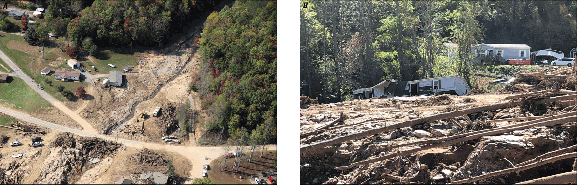
Photographs showing mudflow damage in a small community known as “Craigtown,” in Fairview, North Carolina, on the Flat Creek debris fan that caused 13 fatalities viewed from A, a helicopter and B, the ground. In A, a house was moved by a mudflow from its original location near the excavator in the image to the opposite side of Old Fort Road and can be observed near the bottom of the image. Approximate coordinates for both photographs were 35.558°, −82.317° (Photographs by S. Slaughter. U.S. Geological Survey).
Though the field team did not note an immediate major threat to life and property resulting from landslide movement that was continuing or imminent after the storm sequence ended, the team did observe many localized areas that may have the potential for ongoing hazards, either immediately or with future rainfall. These areas were too numerous for the field team to individually identify during the time-limited mission assignment, so the team instead briefed responders on what they could look for during response and recovery activities using the following event-specific examples of ongoing hazard (fig. 5A–E). Some immediate areas of potential hazard that the team suggested responders be aware of were below the steep exposed slopes left behind by fresh landslides (scarps) where remaining destabilized material could continue to come down, especially if seeps or springs are present, and near the edges of areas that have been undercut by a landslide or flood erosion (fig. 5C). Both cases were common along roads where repair crews may have been operating (fig. 5D). As described earlier in this section, we also determined that future heavy rainfall could reactivate sliding on slopes destabilized during Hurricane Helene, but specific problem areas the field team highlighted include areas partially destabilized where some of the source material was not evacuated (fig. 5A) or where cracks opened in slopes either above landslide sources or where a landslide started to form but did not fail catastrophically (fig. 5B). Fresh cracks indicate the slope has already started moving and allows for easier destabilization by future water infiltration. The field team also noted that concentrated areas of blown down trees may increase the susceptibility of those areas to future debris flows either immediately where root balls were ripped out of the earth, or in future years, because roots helping stabilize the soil can rot or deteriorate (fig. 5E). Guidance on recognizing ongoing landslide hazards is provided in the “Safety Considerations” section.
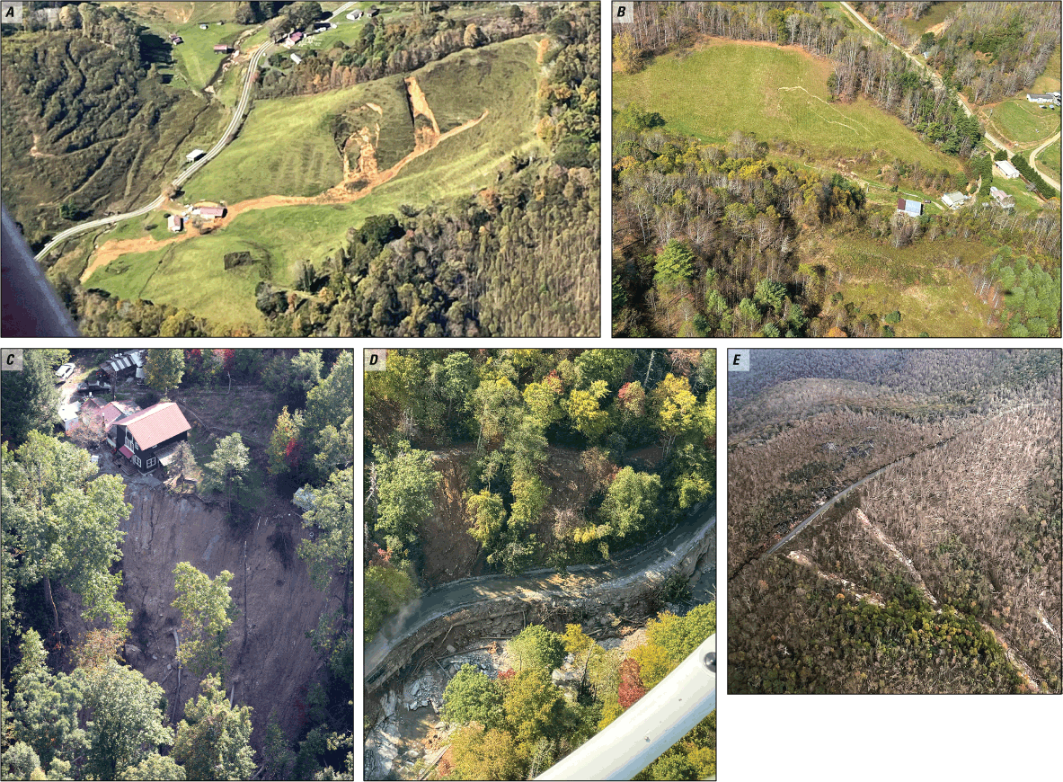
Photographs showing examples of ongoing landslide hazards in North Carolina. A, Destabilized material remaining in the landslide source area, 36.512°, −81.568° (Photograph by F. Rengers, U.S. Geological Survey); B, cracks indicating a landslide started to form, 36.290°, −81.777°(Photograph by J. Godt, U.S. Geological Survey); C, undercut slope resulting in destabilization of the structure and areas above, 35.542°, −82.204° (Photograph by S. Slaughter, U.S. Geological Survey); D, a road that was undercut and destabilized by flood erosion and prone to continued material failing from the slope above, 35.466°, −82.305° (Photograph by K. Allstadt, U.S. Geological Survey); E, Trees blowdown that may increase susceptibility to future debris flows due to loss of root strength, two mudflow source areas are visible to the left, 35.688°, −82.404°(Photograph by F. Rengers, U.S. Geological Survey). Coordinates indicate the approximate location of the photographer.
There is the possibility of acceleration or catastrophic failure of some known large, deep landslides with a history of prior deformation (for example, Hill and others, 2024), so the field team conducted helicopter reconnaissance over these sites. The team did not observe any obvious evidence of poststorm movement that could indicate acceleration. However, tree cover substantially impeded visibility, so on-the-ground field visits would be needed for confirmation.
The U.S. Army Corps of Engineers (Corps) requested a rapid landslide assessment of a maintenance road on Bee Tree Reservoir, a critical drinking water source for Asheville and parts of Buncombe and Henderson Counties. The reservoir was turbid and unpotable from upstream storm-related landslides and runoff, so the Corps was exploring the temporary installation of a pipeline from water sources that were upstream from the reservoir, which would run along the maintenance road. The Corps requested information about potential landslide hazards to staff along the maintenance road. The field team shared with the Corps that they observed no landslide activity that may pose an immediate threat to those individuals working on the road; however, workers in the scars of previous mudflows may be at risk from additional mudflows that could move down the channel, especially during periods of rainfall.
Discussion
Based on the field team’s assessments of likely ongoing hazards discussed in the “Results” section, the team provided custom training materials and safety information to help meet the needs of responding agencies. Some of these products are summarized in this section.
Safety Considerations
The authors provided a one-page guide on landslide safety for homeowners (fig. 6). This guide was a collaborative effort between the USGS and NCGS and was intended for distribution to those individuals affected by landslides and those individuals living in areas susceptible to landslides. It was distributed to a variety of FEMA personnel and local experts and responders with the intent of further distribution to residents. The following is some additional safety consideration text that was provided to responding agencies.
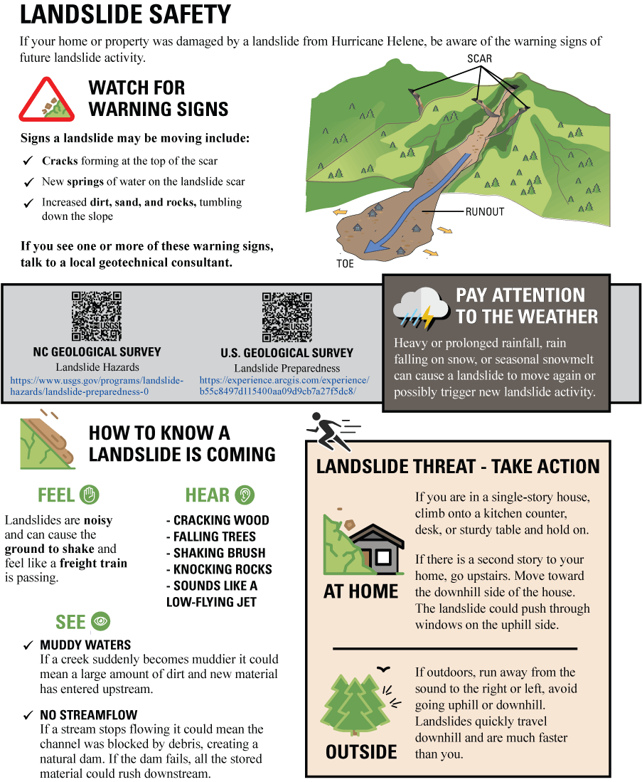
A one-page pamphlet summary provided to the Federal Emergency Management Agency (FEMA) for education on landslide safety for homeowners (modified from U.S. Geological Survey, 2024e). NC, North Carolina
When working in areas affected by landslides, consider the following “watch out” situations:
Rain.—Active rainfall or recent (within the past day) rainfall are the most likely conditions for landslide reactivation, primarily in existing landslide scars. Avoidance of these areas during and immediately following rainfall is suggested, but if work during rainfall is necessary, useful practices can include posting lookouts for ground movement, identifying and marking escape routes, and identifying and marking high areas within structures for refuge, if needed.
Changing ground.—New cracks or springs of water at the landslide scar, or more sand, dirt, and rocks tumbling down the landslide can be indicators of landslide reactivation or new landslide activity. A useful practice when these indicators appear can be to avoid work in the area until the landslide has been reevaluated for activity, and new ground features stop appearing.
Darkness.—Darkness hides upslope landslide scars, making situational awareness more challenging if a landslide were to reactivate. If possible, consider avoiding nighttime work near landslides. If work during nighttime hours is necessary, consider your distance from an existing landslide and the time that may be needed to react.
Mud.—If working in a muddy area that is slick or deep, useful practices can include identifying and marking escape routes, as well as placement of wood planks or plywood over the mud to harden escape routes.
Senses.—Do you see, hear, or feel something that catches your attention while you are working in a landslide area? Landslides are noisy and make the ground shake, they push through and break trees, and you can be warned of their impending arrival by streams either suddenly stopping their flow or rapidly increasing the mud in them. If you sense a potential landslide moving towards you, evacuate immediately. Move away from the sound and do not run downhill.
Guidance for Landslide Recovery Activities
While in North Carolina, the field team provided guidance and considerations for responders during landslide search and recovery activities on how and where debris is generated during landslides and their effects. The following plain-language text and accompanying diagram (fig. 7) are based on the authors’ collective experience from past landslide disasters.
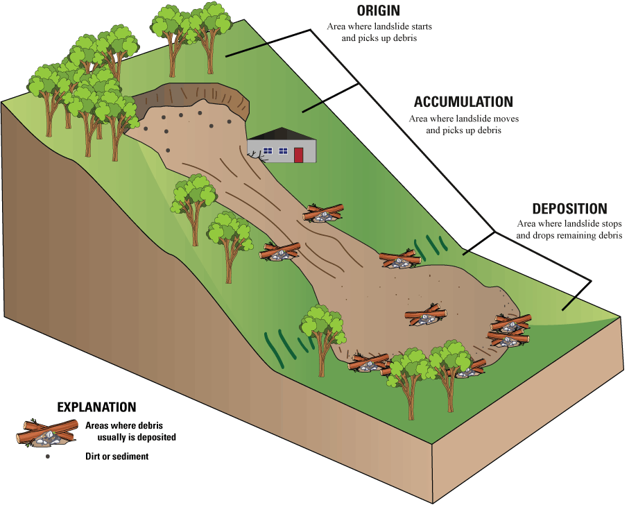
Schematic diagram showing areas where debris transported by a landslide may end up. This diagram was intended to illustrate areas on a landslide to focus recovery efforts for missing people.
Rapidly moving landslides are very powerful and can be compared to a bulldozer pushing trees, rocks, soil, and other material down a hill. Debris in the path of the landslide is picked up by the landslide and pushed downhill. Some debris picked up by the moving landslide may collect along the sides of the moving landslide, like debris piling up along either side of a bulldozer blade. When the landslide reaches the valley floor, it will lose speed and stop. The area at the bottom of a landslide can contain debris picked up by the moving landslide that is not deposited along the landslide margins.
-
• When a landslide strikes a structure, the contents of the structure can be incorporated into the landslide as debris.
-
• When a landslide strikes a vehicle, the entire vehicle can be incorporated into the landslide as debris.
-
• If a landslide stops in a flooded stream, the debris can be incorporated into the stream.
-
• Landslide movement can be rapid and can damage and destroy objects in its path.
Summary
Hurricane Helene produced widespread and damaging landslides that resulted in fatalities at some locations in North Carolina. Aerial field reconnaissance, increasing access to cloud-free imagery, and increasing local reports show that landslides are spatially clustered and separated by regions that are relatively landslide-free. The U.S. Geological Survey Landslide Assessments, Situational Awareness, and Event Response Research (LASER) team was initially activated to support State geologic surveys in the area, especially the North Carolina Geological Survey (NCGS). Subsequently, a smaller team of USGS scientists, the field team that produced this report, was sent to North Carolina to support a mission assignment for FEMA. The material in this report was originally prepared for the Federal Emergency Management Agency under mission assignment DR-4827-NC. The USGS continued to collaborate with the NCGS landslide team as they took over the role as the technical landslide leads for this response.
Initial findings indicate that although substantial rainfall from Hurricane Helene resulted in widespread and destructive landsliding in the southern Appalachian region, the landslide risk had largely decreased by the time of the field team’s assessment (October 2024). Future rainfall and slope modification activities have the potential to heighten the risk of landslide reactivation. High-risk landslides may have not yet been identified because of tree cover in areas where field observations have not yet been conducted.
References Cited
Allstadt, K.E., Godt, J.W., and Slaughter, S.L., 2024a, Oblique aerial photographs from October 13 and 17, 2024, of landslides and flooding caused by Hurricane Helene (ver. 1.1, March 2025): U.S. Geological Survey data release, https://doi.org/10.5066/P1C5W3PQ.
Allstadt, K.E., Schaefer, L.N., Rengers, F., Coe, J., Schmitt, R., Hoch, O., Baxstrom, K., Schulz, W., Mirus, B., Slaughter, S., Cerovski-Darriau, C., Bilderback, E.L., Collins, E., Ellison, S.M., Kostelnik, J., Miles, C., Macías, M., Avdievitch, N., Corbett, S., Martinez, S., Bürgi, P., Bedinger, E., Einbund, M., Toney, L., Jensen, E.K., Ahrendt, S., Belair, G., Barnhart, K.R., and Reid, M., 2024b, The new U.S. Geological Survey LASER Project—Landslide assessments, situational awareness, and event response research [abs], in American Geophysical Union Fall Meeting, Washington, D.C., December 9–13, 2024, Abstracts: American Geophysical Union, abstract NH32B–06.
Beverage, J.P., and Culbertson, J.K., 1964, Hyperconcentrations of suspended sediment: Journal of Hydraulics Division, v. 90, no. 6, p. 117–128. [Also available athttps://ascelibrary.org/doi/abs/10.1061/JYCEAJ.0001128.]
Burgi, P.M., Collins, E.A., Allstadt, K.E., and Einbund, M.M., 2024, Normalized Difference Vegetation Index (NDVI) change map between 9/22/2024 and 10/12/2024, southern Appalachian Mountains (ver. 1.1, March 2025): U.S. Geological Survey data release, accessed March 17, 2025, at https://doi.org/10.5066/P14KDUKK.
Burgi, P.M., Toney, L.D., Collins, E.A., Murphy, C.R., Ellison, S.M., Schmitt, R.G., Allstadt, K.E., Bedinger, E.C., Belair, G.M., Bilderback, E.L., Dunlap, L.R.C.C., Cattanach, B., Crawford, M.M., Einbund, M.M., Fitzpatrick, F.A., Frost, D.J., Grant, A.R.R, Hageman, S.J., Hartman, C., Heckert, A.B., Hoch, O.J., Johnson, B., Jones, E.S., Jurgevich, J., Karantanellis, E., Korte, D., Martinez, S.N., Merschat, A.J., Miles, C.P., Sas, R., Schaefer, L.N., Scheip, C., Soobitsky, R., Trantham, B., and Witt, A., 2025, Preliminary landslide inventory for landslides triggered by Hurricane Helene (September 2024): U.S. Geological Survey data release, accessed March 12, 2025, at https://doi.org/10.5066/P14CHGKS.
Hill, J., Wooten, R., Cattanach, B., Bauer, J., Bozdog, N., Douglas, T., Isard, S., Khashchevskaya, D., Korte, D., Kuhne, J., Owen, L., Prince, P., Scheip, C., Waters-Tormey, C., Wegmann, K., Merschat, A.J., and Carter, M.W., 2024, Big slow-movers, debris slides and flows, and mega-boulders of the Blue Ridge Escarpment, western North Carolina, USA, in Merschat, A.J. and Carter, M.W. eds., Geology and geologic hazards of the Blue Ridge—Field Excursions for the 2024 GSA Southeastern Section Meeting, Asheville, North Carolina, USA, Field Guide, v. 67: The Geological Society of America, p. 13–67.
Hungr, O., Leroueil, S., and Picarelli, L., 2014, The Varnes classification of landslide types, an update: Landslides, v. 11, no. 2, p. 167–194, accessed May 5, 2017, at https://doi.org/10.1007/s10346-013-0436-y.
Martinez, S.N., Stanley, T., Allstadt, K.E., Baxstrom, K.W., Mirus, B.B., Einbund, M.M., Bedinger, E.C., and National Weather Service Greenville-Spartanburg Forecast Office, 2024, Preliminary landslide hazard estimate maps for the 2024 Hurricane Helene landslide emergency response (ver. 2.0, April 2025): U.S. Geological Survey data release, accessed April 18, 2025, at https://doi.org/10.5066/P134ERB9.
Medina, E., 2024, A large family built its own little town. A hurricane killed 11 of them: The New York Times, December 29, 2024, accessed March 11, 2025, at https://www.nytimes.com/2024/12/29/us/hurricane-helene-craigtown-north-carolina-deaths.html.
National Weather Service, 2024, Post tropical cyclone report [Hurricane Helene]: National Weather Service, 3 p., accessed March 11, 2025, at https://www.weather.gov/media/gsp/TropicalEventSummary/PSHGSP_2024AL09_Helene_Summary.pdf.
Rengers, F.K., and Mirus, B.B., 2024, Oblique aerial photography from October 3 to 5, 2024, of landslides caused by Hurricane Helene (ver. 1.1, March 2025): U.S. Geological Survey data release, accessed March 30, 2025, at https://doi.org/10.5066/P1EK8WIT.
Samia, J., Temme, A., Bregt, A., Wallinga, J., Guzzetti, F., Ardizzone, F., and Rossi, M., 2017, Characterization and quantification of path dependency in landslide susceptibility: Geomorphology, v. 292, p. 16–24, accessed April 1, 2025, at https://doi.org/10.1016/j.geomorph.2017.04.039.
Schaefer, L.N., Bilderback, E., Allstadt, K., Baxstrom, K., Bedinger, E., Belair, G., Burgi, P., Cerovski-Darriau, C., Carlson Dunlap, R.L., Chirico, P., Collins, E., Ellison, S., Einbund, M., Godt, J., Grant, A., Fitzpatrick, F., Hall, S.R., Hoch, O., Jones, E.S., Kostelnik, J., Macías, M., McBride, S.K., Martinez, S., Merschat, A.J., Miles, C., Mirus, B.B., Murphy, C., Palermo, L., Rengers, F.K., Riker, J., Schmitt, R., Schulz, W.H., Slaughter, S.L., Toney, L., West, J.M., Bozdog, N., Jurgevich, J., Sas, R., Korte, D., Veach, D., Witt, A., Moore, P., Amatya, P.M, Soobitsky, R., Stanley, T., Bauer, J., Fuemmeler, S., Latham, R., Crawford, M., and Capps, D., 2024, Multi-agency landslide emergency response efforts and insights after Hurricane Helene [abs], in American Geophysical Union Fall Meeting, Washington, D.C., December 9–13, 2024, Abstracts: American Geophysical Union, abstract NH11D–01.
U.S. Geological Survey[USGS], 2024a, Get the latest locations of landslides associated with Hurricane Helene at our Landslide Observations Dashboard * * *: Facebook post, October 4, 2024, accessed February 21, 2025, at https://www.facebook.com/share/p/15t6TK9TNJ/?mibextid=wwXIfr.
U.S. Geological Survey[USGS], 2024b, 2024 Hurricane Helene landslide hazards: U.S. Geological Survey web page, accessed February 18, 2025, at https://www.usgs.gov/programs/landslide-hazards/science/2024-hurricane-helene-landslide-hazards.
U.S. Geological Survey[USGS], 2024c, Hurricane Helene Landslide Observations Dashboard: U.S. Geological Survey, accessed February 19, 2025, at https://www.arcgis.com/apps/dashboards/01b4f51fc0b64002bf7722a9acfc181d.
U.S. Geological Survey [USGS], 2024d, Landslide Assessments, Situational Awareness, and Event Response Research (LASER): U.S. Geological Survey web page, accessed February 19, 2025, at https://www.usgs.gov/programs/landslide-hazards/science/landslide-assessments-situational-awareness-and-event-response.
U.S. Geological Survey, 2024e, Landslide safety: U.S. Geological Survey web page, accessed March 30, 2025, at https://www.usgs.gov/media/images/landslide-safety.
U.S. Geological Survey (@usgs_landslides and usgs_colorado) [USGS], 2024f, [Photographs by U.S. Geological Survey of aircraft, flight paths, and aerial view of a landslide]: Instagram post, October 23, 2024, accessed February 21, 2024, at https://www.instagram.com/p/DBeQd_mJW6D/?igsh=MW9lZ3lvd21qZ2R5Yw==.
Wooten, R.M., Witt, A.C., Miniat, C.F., Hales, T.C., and Aldred, J.L, 2016, Frequency and magnitude of selected historical landslide events in the southern Appalachian Highlands of North Carolina and Virginia—Relationships to rainfall, geological and ecohydrological controls, and effects, in Greenberg, C.H., and Collins, B.S., eds., Natural disturbances and historic range of variation—Type, frequency, severity, and post-disturbance structure in central hardwood forests USA, v. 32 of Managing forest ecosystems: Cham, Switzerland, Springer, p. 203–262, accessed October 14, 2025, at https://doi.org/10.1007/978-3-319-21527-3_9.
Appendix 1. Resources and Information Products
-
• USGS “2024 Hurricane Helene Landslide Hazards” web page—This web page serves as an event summary to communicate timely science information to USGS partners. This includes links to dashboard and available data releases (USGS, 2024a).
-
• USGS Landslide Inventory Dashboard—Collaborative effort by State, Federal, and other partners to populate landslides on a map using a variety of sources. The Hurricane Helene 2024 Landslide Observations dashboard was live and continuously updated during the response (USGS, 2025).
-
• “2024 Hurricane Helene Landside Response” ScienceBase landing page—A landing page linking to the data releases related to Hurricane Helene (USGS, 2024b).
-
• Landslide rainfall and susceptibility maps—Data release of two versions of preliminary landslide hazard estimate maps for Hurricane Helene using USGS and National Aeronautics and Space Administration (NASA) susceptibility models coupled with the National Weather Service (NWS) Greenville–Spartanburg, South Carolina Forecast Office rainfall data (Martinez and others, 2024).
-
• Fixed-wing aerial reconnaissance photographs—More than 2,000 geotagged photographs acquired during October 3–5, 2024, aerial surveys from a fixed-wing aircraft (Rengers and Mirus, 2024).
-
• Helicopter aerial reconnaissance photographs—Categorized geotagged photographs of landslides and flooding damage collected by helicopter October 13 and 17, 2024, for the Federal Emergency Management Agency (FEMA) mission assignment (Allstadt and others, 2024).
-
• Normalized Difference Vegetation Index (NDVI) change map—A map depicting where vegetation was removed or damaged due to landslides, debris flows, flooding, and wind damage during Hurricane Helene (Burgi and others, 2024).
-
• USGS “Landslide Basics” web page—An education web page dedicated to helping the public understand landslides, landslide warning signs, and what to do after a landslide (USGS, undated).
References Cited
Allstadt, K.E., Godt, J.W., and Slaughter, S.L., 2024, Oblique aerial photographs from October 13 and 17, 2024, of landslides and flooding caused by Hurricane Helene (ver. 1.1, March 2025): U.S. Geological Survey data release, https://doi.org/10.5066/P1C5W3PQ.
Burgi, P.M., Collins, E.A., Allstadt, K.E., and Einbund, M.M., 2024, Normalized Difference Vegetation Index (NDVI) change map between 9/22/2024 and 10/12/2024, southern Appalachian Mountains (ver. 1.1, March 2025): U.S. Geological Survey data release, accessed March 17, 2025, at https://doi.org/10.5066/P14KDUKK.
Martinez, S.N., Stanley, T., Allstadt, K.E., Baxstrom, K.W., Mirus, B.B., Einbund, M.M., Bedinger, E.C., and National Weather Service Greenville-Spartanburg Forecast Office, 2024, Preliminary landslide hazard estimate maps for the 2024 Hurricane Helene landslide emergency response (ver. 2.0, April 2025): U.S. Geological Survey data release, accessed April 18, 2025, at https://doi.org/10.5066/P134ERB9.
Rengers, F.K., and Mirus, B.B., 2024, Oblique aerial photography from October 3 to 5, 2024, of landslides caused by Hurricane Helene (ver. 1.1, March 2025): U.S. Geological Survey data release, accessed March 30, 2025, at https://doi.org/10.5066/P1EK8WIT.
U.S. Geological Survey [USGS], 2024a, 2024 Hurricane Helene landslide hazards: U.S. Geological Survey web page, accessed March 11, 2025, at https://www.usgs.gov/programs/landslide-hazards/science/2024-hurricane-helene-landslide-hazards.
U.S. Geological Survey [USGS], 2024b, 2024 Hurricane Helene landslide response data: U.S. Geological Survey data release, accessed March 11, 2025, at https://doi.org/10.5066/P1G6Y6HP.
U.S. Geological Survey [USGS], 2025, Hurricane Helene Landslide Observations Dashboard: U.S. Geological Survey, accessed January 11, 2025, at https://www.arcgis.com/apps/dashboards/01b4f51fc0b64002bf7722a9acfc181d.
U.S. Geological Survey [USGS], [undated], Landslide basics: U.S. Geological Survey web page, accessed March 11, 2025, at https://www.usgs.gov/programs/landslide-hazards/landslide-basics.
Abbreviations
Corps
U.S. Army Corps of Engineers
EOC
Emergency Operations Center
FEMA
Federal Emergency Management Agency
LASER
Landslide Assessments, Situational Awareness, and Event Response Research
lidar
Light Detection and Ranging
NASA
National Aeronautics and Space Administration
NCGS
North Carolina Geological Survey
NDVI
Normalized Difference Vegetation Index
USGS
U.S. Geological Survey
UTC
coordinated universal time
Publishing support provided by the Science Publishing Network, Denver and Tacoma Publishing Service Centers
For more information concerning the research in this report, contact the
Center Director, USGS Geologic Hazards Science Center
Box 25046, Mail Stop 966
Denver, CO 80225
(303) 273-8579
Or visit the Geologic Hazards Science Center website at
https://www.usgs.gov/centers/geologic-hazards-science-center
Disclaimers
Any use of trade, firm, or product names is for descriptive purposes only and does not imply endorsement by the U.S. Government.
Although this information product, for the most part, is in the public domain, it also may contain copyrighted materials as noted in the text. Permission to reproduce copyrighted items must be secured from the copyright owner.
Suggested Citation
Allstadt, K.E., McBride, S.K., Godt, J.W., Slaughter, S.L., Baxstrom, K.W., Sobieszczyk, S., and Stull, A., 2025, Preliminary field report of landslide hazards following Hurricane Helene: U.S. Geological Survey Open-File Report 2025–1028, 15 p., https://doi.org/10.3133/ofr20251028.
ISSN: 2331-1258 (online)
Study Area
| Publication type | Report |
|---|---|
| Publication Subtype | USGS Numbered Series |
| Title | Preliminary field report of landslide hazards following Hurricane Helene |
| Series title | Open-File Report |
| Series number | 2025-1028 |
| DOI | 10.3133/ofr20251028 |
| Publication Date | June 09, 2025 |
| Year Published | 2025 |
| Language | English |
| Publisher | U.S. Geological Survey |
| Publisher location | Reston VA |
| Contributing office(s) | Geologic Hazards Science Center - Landslides / Earthquake Geology |
| Description | Report vi, 15 p.; Data Release |
| Country | United States |
| State | North Carolina, South Carolina, Tennessee, Virginia |
| Online Only (Y/N) | Y |