

Assessing the Potential for Evaluation of Wildland Fire Models Using Remotely Sensed Data—Summary Proceedings from a U.S. Geological Survey Workshop in 2024
Links
- Document: Report (4.61 MB pdf) , HTML , XML
- NGMDB Index Page: National Geologic Map Database Index Page (html)
- Download citation as: RIS | Dublin Core
Acknowledgments
We would like to give thanks to Ruddy Mell from the U.S. Department of Agriculture Forest Service and Eric Mueller of the National Institute of Standards and Technology of the Fire Dynamics Simulator team and Rodman Linn, David Robinson, and Julia Oliveto of the Los Alamos National Laboratory QUIC-Fire modelling team for their presentations. Additionally, we would like to thank U.S. Geological Survey colleagues Anthony Feliciano, J.D. Mejstrik, Jeffery Ganuza, and Stevie Mackie from the National Civil Applications Center and Birgit Peterson from the Earth Resources Observation and Science Center for their presentations on remotely sensed wildfire datasets. We are also appreciative of James Meldrum for his assistance with planning the workshop and feedback on this report.
Abstract
On September 19, 2024, the U.S. Geological Survey (USGS) held a virtual workshop titled “Potential for Evaluation of Fire Models with Remote Sensing Data Workshop” to assess the feasibility of using remotely sensed datasets to evaluate next-generation wildland fire behavior models. Remote sensing and fire modelling experts gathered to: (1) assess the suitability of a variety of classified, commercial, and publicly available remotely sensed datasets for advancing fire model evaluation; (2) develop ideas on how to integrate remotely sensed data products with fire model inputs and outputs; and (3) identify any barriers and limitations to performing an evaluation of next-generation fire models. The USGS National Civil Applications Center, USGS Earth Resources Observation and Science Center, and USGS Fort Collins Ecosystem Science Center presented information on remote sensing datasets for three Arizona wildfire case studies. The development teams of the Fire Dynamics Simulator and QUIC-Fire fire behavior models presented their models and current evaluation methodologies. Interspersed with these presentations were discussions regarding how to expand current wildfire remote sensing data collection efforts beyond operational needs to assist in future fire modeling.
Workshop participants agreed that several of the remote sensing datasets have potential for wildfire model evaluation. However, participants also identified several barriers and complications to performing a model evaluation including key gaps in wildfire datasets; uncertainties related to model fire-atmosphere reinitiation; lack of ground truthing and atmospheric correction of remotely sensed datasets; and differences in spatial, geolocation, radiometric, and temporal resolutions between the datasets and models. Further, the absence of standardized methodologies for image interpretation, poor understanding of sensor capabilities and limitations, and a lack of automation also hinder model evaluation efforts. Based on feedback from this workshop, USGS fire modelers are considering a project to address the uncertainties related to fire model reinitiation and encouraging fire practitioners to collaborate with remote sensing experts on wildland fires to improve data collection for a broader community of practice. Additionally, multiagency efforts are in development for a comprehensive cross-sensor validation and ground-truth campaign to test spatial, spectral, and geolocation sensor capabilities, determine limitations, and identify observational gaps for future sensor development and acquisition.
Introduction and Background
A new generation of fire behavior models is being developed to address the increasing need to understand and predict wildland fire behavior and effects under a broad range of burning conditions. This next generation of fire models—including those such as the Fire Dynamics Simulator (FDS; Mell and others, 2007, 2009; Bova and others, 2015), QUIC-Fire (Linn and others, 2020), and FIRETEC (Linn and Harlow, 1997; Linn and others, 2002; Linn and Cunningham, 2005)—use advanced computer simulation techniques to represent and model the various processes driving fire behavior in wildland systems. Though these modeling systems often include empiricism, they are classified as physical or quasi-physical models (Sullivan, 2009a). These models have several advantages over the historically used empirical and quasi-empirical models (Sullivan, 2009a, b, c), including that they can explicitly resolve fire behavior at fine resolutions (to a sub-meter scale), capture the influences and interactions of fuels, winds, terrain, and fire on a landscape in three dimensions, and have potential to be applied to a wide range of fuel types and burning conditions (Or and others, 2023). As part of the development and adoption of these new models, it is crucial that they be evaluated against real-world wildland fire data to determine the reliability of the model predictions across a range of scenarios and to identify possible flaws and future research for model improvement (Alexander and Cruz, 2013). Evaluation of these models is critical for supporting the research-to-operations transition by building confidence in model results and enabling land managers to use modeling tools for real-time decision making (Hoffman and others, 2018).
Past work to evaluate these fire behavior models has included comparisons against empirical fire spread models (Linn and Cunningham, 2005; Pimont and others, 2012; Ritter and others, 2020; Atchley and others, 2024), laboratory experiments (Marino and others, 2012; Perez-Ramirez and others, 2017), laboratory and field-scale fire simulations (Mell and others, 2007, 2009; Dupuy and others, 2011; Hoffman and others, 2016; Liu and others, 2017), and other next-generation fire behavior models (Linn and others, 2020). These evaluations show that the models can simulate realistic fire behaviors and effects under moderate conditions; however, they do not capture the full range of weather conditions, fuels, or fire behaviors that can be present during wildfires or larger operational prescribed fires. The models’ limitations may be important for the increasing number of wildfires occurring under extreme environmental conditions (for example, hot, dry, or windy). Fire modelers have also evaluated models using re-creations of wildfires (Bossert and others, 2000; Gallagher and others, 2021), though these evaluations take advantage of preexisting measurements of fuels in the area, stationed wind sensors within range of the fires, and on-the-ground observations of fire behavior from incident responders. As most wildfires do not have these datasets and sensors readily available, model evaluation efforts have primarily focused on prescribed and laboratory fires.
Prescribed fires and wildfires differ in several ways, including their scales, planning horizons, environmental conditions, and fire behaviors (Hiers and others, 2020); therefore, the model validation process for the two types of fires will also differ. Prescribed fires are planned events with designated containment units so data collection devices can be positioned to capture environmental and fire information at a high resolution before and throughout the operational window. Wildfires are unplanned and do not have prescribed bounds so responders to wildfires often do not have the opportunity to place additional sensors ahead of time and must rely on existing in situ sensors to provide data. However, additional remote sensing resources can be ordered for both types of fires to provide high-resolution imagery and environmental data to track fire behavior and perimeters. Although there are numerous existing experimental datasets from free spreading (Cruz and others, 2025) and prescribed fires (Bonner and others, 2021) that could be applied in model evaluation, the data collected during these experiments are often insufficient to evaluate next generation fire behavior models or have considerable uncertainties. Because of the abundance and diversity of wildfire events globally and the coverage of operational datasets, we look toward wildfires for data and validation.
Next generation fire behavior models require a large amount of highly precise environmental data to simulate a real burning environment, much of which can be collected using remote sensing methods (Filkov and others, 2018). Environmental information, such as topography, fuel structure and composition, weather, and fire locations, are required at a meter level throughout a prefire landscape to accurately initiate a wildfire simulation. Additionally, to fully evaluate fire behavior model simulations against real wildfires, it is necessary to collect environmental data during the active burning period and post fire. These model requirements—to collect large amounts of data with fine temporal and spatial resolutions over large scales—necessitate the use of remote sensing-sourced data. Satellite, aircraft, and terrestrial sensors enable a wide variety of environmental data to be quickly and consistently collected at fine resolutions over large areas.
Improvements in remote-sensing technologies and a greater range of classified, commercial, and publicly available (refer to the “Glossary” section of this report for the applicable definition) wildfire remote-sensing datasets offer the opportunity to better evaluate fire behavior models. However, there are several current barriers to evaluation, including determining which datasets and derivatives thereof to use, associating remotely sensed datasets to fire behavior model inputs and outputs, and identifying the limitations and uncertainties involved with evaluating a fire model. Previous discussions with sensor operators and data users revealed that this is further confounded by a general lack of sensor performance for fire relative to spectral sensitivities and temporal resolutions, geolocation inaccuracy, and spatial constraints in complex landscapes and under variable atmospheric conditions.
To help identify possible future research areas related to remote sensing and fire behavior model evaluation, a mix of remote-sensing and fire-modeling researchers and developers (app. 1) came together on September 19, 2024, for a day-long virtual workshop to assess the feasibility of using remotely sensed datasets to evaluate next-generation wildland fire behavior models. U.S. Geological Survey (USGS) remote-sensing experts from the National Civil Applications Center and the Earth Resources Observation and Science Center identified three Arizona wildfires (the 2023 Kane, 2022 San Rafael, and 2022 Tunnel Fires) and presented information on 19 classified, commercial, and publicly sourced remotely sensed environmental datasets for these fires. Developers of the FDS and QUIC-Fire models presented on the respective information needs, model inputs and outputs, and evaluation goals for their fire behavior models. Workshop discussions addressed topics including operational remote-sensing tasking, dataset scale and resolution requirements for modelers, derivatives of remote-sensing datasets, dataset-to-fire model linkages, missing or incomplete datasets and possible proxies, model uncertainties, previously accomplished model evaluation methodologies, and prospective next steps. This report provides a summary of the discussions that took place during the 2024 virtual workshop “Potential for Evaluation of Fire Models with Remote Sensing Data Workshop.”
Workshop Overview and Goals
The 2024 virtual workshop “Potential for Evaluation of Fire Models with Remote Sensing Data Workshop” and the discussions therein were initiated by the U.S. Department of Defense Environmental Security Technology Certification Program advance fire model evaluation efforts and support the continued growth of the Innovation Landscape Network and the invested stakeholders. The coordinators of the workshop invited a mix of remote-sensing experts and fire modelers (app. 1) to discuss how best to take advantage of remote-sensing technologies to evaluate fire models including FDS and QUIC-Fire. Remote sensing experts from the National Civil Applications Center and Earth Resources Observation Science Center spoke on remotely sensed datasets and possibilities for expanding the usefulness and automation of existing and future remote-sensing systems. Fire model developers of FDS from the U.S. Department of Agriculture Forest Service and the National Institute of Standards and Technology (NIST) and developers of the FIRETEC and QUIC-Fire models at Los Alamos National Laboratory presented on their model needs and evaluation efforts. This workshop was primarily designed to be an information exchange between remote-sensing and fire-modeling experts to help both groups meet their respective and interdependent objectives.
The goals of the September 19, 2024, workshop were to:
-
1. Assess the suitability of a variety of classified, commercial, and publicly available remotely sensed datasets for advancing fire model evaluation.
-
2. Develop ideas to integrate remotely sensed data products with fire model inputs and outputs.
-
3. Identify barriers and limitations to performing an evaluation of next-generation fire behavior models.
Methods
To provide material for workshop discussions, the workshop coordinators developed presentations on remotely sensed wildfire response datasets available for fire behavior model evaluation. We primarily described datasets collected for the southwest region of the United States as our funding directives from the U.S. Department of Defense Environmental Security Technology Certification Program were to support the Southwest Innovation Landscape Network fire model evaluation efforts. We identified three past wildfires (2023 Kane, 2022 San Rafael, and 2022 Tunnel Fires) in Arizona to use as case studies for our wildfire remote-sensing dataset presentations. Using the perimeters and burning period of these wildfires, we assessed and presented the classified, commercial, and public remote-sensing datasets commonly available for use in fire modelling validation.
Wildfire Selection
We identified wildfires for remote-sensing dataset assessment by first searching for all wildfires occurring in Arizona during the 5 years from January 2020–August 2024. We then filtered down the number of selected wildfires to 10 by only including those which:
-
• Burned for at least 5 consecutive days, and
-
• Had various classified and unclassified remote-sensing datasets available.
From these 10 fires, we collectively selected 3 wildfires for further analyses, aiming for wildfires that represented a variety of terrain, vegetation, and sizes (table 1; fig. 1A–D).
Table 1.
Arizona fires selected for the 2024 virtual workshop on assessing the potential for evaluation of wildland fire models using remotely sensed data.[Dates shown as month/day/year.]
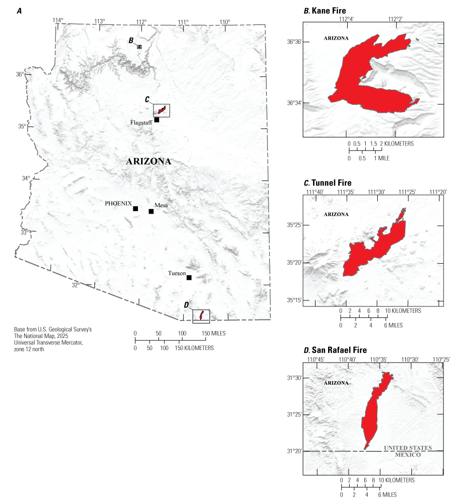
A, map of Arizona showing fire perimeters for the B, 2023 Kane, C, 2022 Tunnel, and D, 2022 San Rafael Fires. km, kilometer.
Remote Sensing Data Collection
We searched for classified, commercial, and publicly available remotely sensed datasets for our three selected wildfires. For each wildfire, we used a hand-rendered fire perimeter generated from classified Aircraft 3/Firehawk data (table 2; fig. 1) to filter the remotely sensed datasets to a specific wildfire location. We used the active fire dates (table 1) of each wildfire to temporally filter relevant datasets to the pre, active, and postfire timeframes.
Table 2.
Classified, commercial, and publicly available remote-sensing datasets for fire behavior modeling.[NGA, U.S. National Geospatial-Intelligence Agency; NCAC, U.S. Geological Survey National Civil Applications Center; NA, none available; DoD, U.S. Department of Defense; NIROPS, U.S. Forest Service National Infrared Operations; FS, U.S. Department of Agriculture Forest Service; lidar, light detection and ranging; USGS, U.S. Geological Survey; NASA, U.S. National Aeronautics and Space Administration; NIFC, National Interagency Fire Center]
| Dataset name | Data type | Owner or contributor | Classification | Web page address |
|---|---|---|---|---|
| Aircraft3/Firehawk | Fire perimeters | NGA and NCAC | Classified | NA |
| FireGuard | Fire perimeters | NGA and DoD | Classified | NA |
| NIROPS/Phoenix Sensor | Fire perimeters, intensity | FS NIROPS | Commercial | https://fsapps.nwcg.gov/nirops/ |
| NIROPS/TK7-TK9 | Fire perimeters, intensity | FS NIROPS Contracts | Airborne | https://fsapps.nwcg.gov/nirops/ |
| BlackSky Global 1-20 | Multispectral | BlackSky Holdings Inc. | Commercial | https://calval.cr.usgs.gov/apps/compendium/detail?p=h/yyMzecUKEneo/8vUbqDQ== |
| Pelican-1 | Multispectral | Planet Inc. | Commercial | https://calval.cr.usgs.gov/apps/compendium/detail?p=aesT/d+xUV7c0I2Bb4bwzA== |
| SkySat 01-21 | Multispectral | Planet Inc. | Commercial | https://calval.cr.usgs.gov/apps/compendium/detail?p=+4M2zr3s7Wh6Q2B5YJm6hQ== |
| SuperDove Flock | Multispectral | Planet Inc. | Commercial | https://calval.cr.usgs.gov/apps/compendium/detail?p=YNuejBHUBteJvOesFQLmgQ== |
| WorldView 1-3 | Multispectral | DigitalGlobe Inc. | Commercial | https://calval.cr.usgs.gov/apps/compendium/detail?p=fozjrnIPNs+vh4z42FXT4Q== |
| 3-Dimensional Elevation Program (3DEP) | Lidar | USGS | Public | https://apps.nationalmap.gov/lidar-explorer/#/ |
| Burned Area Reflectance Classification (BARC) | Burn severity | FS and USGS | Public | https://burnseverity.cr.usgs.gov/baer/ |
| Global Ecosystem Dynamics Investigation (GEDI) | Lidar | NASA | Public | https://calval.cr.usgs.gov/apps/compendium/detail?p=TbmTRLq60bEA20CDS0XS1w== |
| Interagency Ecosystem LiDAR Monitoring (IntELiMon) | Lidar | Multiple | Public | https://dmsdata.cr.usgs.gov/lidar-monitoring/viewer/ |
| LANDFIRE | Vegetation, fuels, fire regimes | FS and USGS | Public | https://landfire.gov/ |
| LANDSAT 8-9 | Multispectral | NASA and USGS | Public | https://calval.cr.usgs.gov/apps/compendium/detail?p=0EqQWOVINgvtSk6/7G7Qlw== |
| Monitoring Trends in Burn Severity (MTBS) | Burn severity | FS and USGS | Public | https://www.mtbs.gov/ |
| NIFC - Fire Perimeters and operational data | Fire perimeters, operational data | NIFC | Public | https://data-nifc.opendata.arcgis.com/ |
| Rapid Assessment of Vegetation Condition After Wildfire (RAVG) | Burn severity | FS and USGS | Public | https://burnseverity.cr.usgs.gov/ravg/ |
| Remote Automatic Weather Stations (RAWS) | Weather | Multiple | Public | https://raws.nifc.gov/ |
| Sentinel 2 A-C | Multispectral | European Space Agency | Public | https://calval.cr.usgs.gov/apps/compendium/detail?p=W2+54RoMXIkuOxZbKa1hEQ== |
To filter the remote sensing datasets for evaluation, we selected only those datasets relevant to fire behavior simulation modelling. Specifically, we only included datasets that help to determine fire perimeters, intensities, effects, and behaviors, as well as datasets with information regarding fuels, terrain, and fire weather. Following this process, we selected 2 classified, 1 airborne, 6 commercial, and 11 publicly available remotely sensed datasets and metadata to use in presentations and discussions during the workshop (table 2).
Next-Generation Fire Behavior Models
We invited the development teams of FDS and QUIC-Fire to present on their respective wildland fire behavior models, which are shown in figures 2A–B. Presenters from these teams identified model inputs and outputs, described present and future data needs, and addressed past model evaluations undertaken to validate their model. As these presentations were only intended to introduce the model to remote sensing experts and set the scene for discussions, we did not go into detail on model parameters.
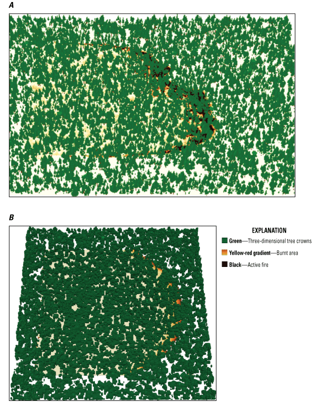
Next-generation fire behavior model simulation results shown at 350 seconds into the model run using A, the Fire Dynamics Simulator (simulated area shown is 1,100 meters [m] × 400 m × 220 m with variable horizontal resolution between 1–2 m), and B, QUIC-Fire (simulated area shown is 1,200 m × 1,200 m × 38 m with 2 m × 2 m × 1 m cell resolution). The simulations are looked at from a birds-eye view.
Fire Dynamics Simulator
The FDS is a powerful computational fluid dynamics model codeveloped by NIST and the U.S. Department of Agriculture Forest Service to simulate fire-driven fluid flow (McGrattan and others, 2013). It uses large eddy simulation techniques to solve governing equations for low-speed, thermally driven flow, focusing on smoke and heat transport from fires. The FDS has been widely used since its public release in 2000 for applications such as designing smoke handling systems (Sotiriadis and Kontoleon, 2023), studying sprinkler/detector activation (Hopkin and Spearpoint, 2019), and simulating building interior fires (Moon and others, 2021). The FDS has been upgraded by the Forest Service and NIST to model wildfire behavior across a range of scenarios including in complex terrain (Innocent and others, 2023), heterogenous vegetation (Ziegler and others, 2017), and for multiple interacting fires (Morvan and others, 2009) such as during a prescribed burning event. Vegetation can be represented as either a generic landscape value or as individual trees and shrubs down to the centimeter scale. The model can export a variety of outputs relevant to fire, smoke, and fuels.
QUIC-Fire
QUIC-Fire is a three-dimensional (3D) coupled atmospheric-fire behavior and spread modeling tool developed by the Los Alamos National Laboratory (Linn and others, 2020). This model couples the 3D wind solver QUIC-URB (Singh and others, 2008; Robinson and others, 2023) to the cellular automata (CA) fire-spread model Fire-CA to represent dynamic fire-atmospheric interactions and fire spread. QUIC-Fire was developed to require less computational time and a lower cost burden than most computational fluid dynamics fire-atmospheric models (for example, FIRETEC) and has greater fidelity for fire dynamics and fuel structure than traditional models (for example, FlamMap). Inputs for the model include 3D fuel and elevation grids; wind input locations with wind speeds, directions, and input heights; and a spatially and temporally explicit ignition pattern. Outputs from the model are saved during the simulation and include information on fuel and moisture consumption, winds, fire energy release, and emissions. Overall, QUIC-Fire is a fast-running model intended to enable land managers and researchers to rapidly and accurately simulate wildland fire behavior and effects under complex 3D vegetative fuel structures, topographies, weather conditions, and ignition patterns.
Discussion
Workshop participants acknowledged that the data from the remotely sensed datasets that were presented are useful for parameterizing many of the fuels, terrain, and weather conditions required for simulating a wildfire, and have further use in comparing real and simulated fire perimeters, area growth, and canopy consumption. Three-dimensional forest structure and surface fuel model inputs can be built from multiple remote-sensing resources, including lidar (Castorena and others, 2025), multispectral imagery (Abdollahi and Yebra, 2023; Chávez-Durán and others, 2024), and derived sources such as LANDFIRE (Rollins, 2009). Digital elevation models derived from lidar scans, such as those included in the 3D Elevation Program that is also known as 3DEP (Snyder, 2012), cover the entirety of the United States and provide the necessary information to build terrain inputs for any landscape. Weather inputs such as wind velocities and smoke composition and transport have been gathered from permanent Remote Automatic Weather Stations (Warren and Vance, 1981; Horel and Dong, 2010) and portable weather sensors (Hartung and others, 2006) and used in past model evaluations. Spatial fire behavior metrics including the location of fire on the landscape and its spread can be identified through the multispectral snapshots provided by various remotely sensed datasets (table 2).
Barriers and Limitations
Despite these uses for remotely sensed datasets, participants noted several barriers and limitations that would hinder the evaluation of fire behaviors and effects simulated in FDS and QUIC-Fire. Barriers to model evaluation include missing, incomplete, or uncertain datasets that prevent fire modelers’ ability to fully understand and simulate the various burning environments and behaviors of wildfires. Limitations are unknowns and uncertainties in the datasets and models that must be scientifically resolved before model evaluation. In the following subsections, we identify and discuss these barriers and limitations to model evaluation efforts and propose ideas and future research that could address these issues.
Missing Datasets
Although the identified remote-sensing datasets cover a range of existing conditions and landscapes, workshop participants noted that some key wildfire scenarios were not represented. For example, the presented datasets did not discern wildfire events with abrupt transitions in wind conditions (Potter and Hernandez, 2017), wherein the wind quickly changes directions, leading to changes in the direction and speed of fireline spread, fire behaviors, and how operational forces choose to respond to the fire. Also missing from these datasets were scenarios characterized by atmospheric instability (Giannaros and others, 2022; Menezes and others, 2024) and wind blow-up (Byram, 1954; Leach and Gibson, 2021), which affect turbulence and the vertical flow of air leading to erratic fire behaviors. Capturing wildfire and associated environmental data for these scenarios and evaluating how well the models can represent fire behaviors are of particular interest as wildfire operators must be able to quickly interpret and respond to atmospheric and wind shifts. Once evaluated, these fire behavior models can be used to better understand the fire-atmosphere interactions under these conditions and to train wildfire responders for suppression activities.
Additional remotely sensed data are needed for a more comprehensive understanding of fire. These include data from lidar to determine fuel volumes and structure and methods to rapidly assess fuel conditions like moisture and type in the vicinity of an active fire near the time of the fire itself. Lidar systems are readily available off the shelf, and methods exist for measuring fuel structures from lidar (Arkin and others, 2021; Marcozzi and others, 2023; Xi and others, 2023) but some development may be needed to rapidly process and disseminate derived data into a format for model inputs. Conducting broad-area fuel condition assessments using remote sensing techniques would likely involve some spectral methodology coupled with other methods like synthetic aperture radar. Significant investment is required to develop, test, and validate methods.
Currently (2025), there are no remotely sensed datasets describing the spatial distribution of fuel moistures at fine enough spatial resolutions and timeliness for fire behavior modeling in FDS or QUIC-Fire. Live crown and dead surface fuel moisture contents (FMC), which are the amount of water in a leaf relative to the mass of dry leaf matter, are integral components of fire behavior models as they partially determine the probability of ignition, effective heat released during combustion (Rothermel, 1983), and further affect fire behaviors such as rate of spread, fire intensity, and fuel consumption (Matthews, 2013; Mišić and others, 2024). Dead surface FMC are closely tied to meteorological conditions and thus can be estimated from climate and weather data (Viney, 1991; Sharples and others, 2009) with knowledge of the vegetative fuels. Live canopy FMC, however, are a result of interactions between plant physiologies, fuel structure, soil moisture, and meteorological conditions (Danson and Bowyer, 2004), making these values more spatially variable than dead FMC and necessitating additional work to estimate. Current methods of estimating live FMC using remote sensing datasets are limited by spectral reflectance detecting issues, coarse-resolution data inputs for empirical modeling of FMC, data-heavy physics-based algorithms, quantifying error, and other constraints (Yebra and others, 2013). Further, many of the methods are site- or vegetation-specific and require large amounts of sampling to determine FMC, making them challenging to operationalize (Yebra and Chuvieco, 2009). Therefore, there is a need for novel remote sensing methodologies that can be applied to a wide variety of ecosystems and can account for these issues to estimate live and dead FMC at fine scales and frequencies.
Remote Sensing Dataset Quality
Assessing the quality of remote sensing methodologies is critical for building datasets that accurately represent real landscapes. Errors can be introduced during the acquisition, processing, analysis, and conversion of raw, remotely sensed data into interpreted dataset products (Lunetta and others, 1991), and each introduced error can add or build on the last to misrepresent reality. Sources of error stem from sensor properties (for example, calibration, sensitivity, radiometric or geometric distortion), environmental conditions (for example, shadows, clouds, smoke, noise, water vapor aerosol content, obscurity because of landscape features, natural landscape variability), and human-introduced error (for example, best sensors to use, operator-to-operator variability in interpretation, and postprocessing steps; Campbell and Wynne, 2011).
Although environmental conditions cannot be controlled, many of these other error sources can be accounted for. Expanding the common knowledge and understanding of the multiple sensors available and their best use cases can support wildfire managers and researchers in selecting appropriate sensors for their tasks. Additionally, sensors can be calibrated to better capture landscape features and reduce distortion and error (Kaasalainen and others, 2011; Fernández Pareja and others, 2013). Preprocessing steps such as cloud and cloud shadow detection systems, relative radiation correction, and geometric correction (Campbell and Wynne, 2011) can be implemented to better detect and compensate for issues in the raw imagery (Qi and others, 2018). Automation of the postprocessing steps typically done by individuals will improve the consistency and expediency of remote-sensing datasets and remove much of the human error element. Finally, using ground truthing to quantify error and validate remote-sensing datasets will help remote-sensing scientists adjust sensing methodologies to better match what is present on the landscape (Nagai and others, 2020). Through careful selection of sensors and sensing methodologies, understanding sensor properties and uncertainties, science-driven automation of postprocessing steps, and validation of datasets, remotely sensed datasets will become more useful for both operational wildfire mapping and fire model evaluations.
Each of the remotely sensed datasets evaluated during this workshop is discretely tasked and manually generated to support operational wildfire suppression requirements. As the fire environment changes and wildfire frequency and size expand, cost-effective and scalable methods can be developed and tested to augment and eventually stand in for human interpretation. Additionally, a coordinated approach for data tasking can be developed instead of single-purpose tasking from single-purpose instruments. For example, using an airborne thermal sensor to detect and map fires, an ensemble collection concept can be implemented to not only obtain tactical data for direct attack needs, but also to collect data useable for fuel evaluation, infrastructure assessments, and other needs (for example, fire model evaluation). As of 2025, these data are collected in a piecemeal, uncoordinated fashion, creating challenges in access to disparate data sources, in the alignment of spatial and temporal aspects, and in the area of coverage across datasets.
Imagery Interpretation and Mapping
Because current fire-mapping methods are exclusively manual, they are subject to operator biases that lead to inconsistencies in interpretation. As the fire environment evolves, automated detection and mapping tools are essential to meet the growing need for mapping products and model inputs—especially the ability to calculate the rate of spread from imagery. Moreover, as platforms and sensors with long dwell times become available, manual processing will be unable to keep up with collection and dissemination tempos. Mapping standards are required to ensure that automation is consistent, especially if manually derived inputs are to be used for training data to prepare artificial intelligence or machine learning methods. Standard, deterministic image-processing methods need consistent rules for algorithm development.
Using remotely sensed data to produce model inputs or validate model outputs requires interpreting the dataset and extracting information to develop mapped products. Various methods can be applied based on the type of product desired. In addition, interpretation can be subjective in some cases and lead to inconsistencies depending on the individual analyst producing the information product. Although some steps to preprocess data and develop draft products can be automated, there are often manual steps that also need to be completed to create a final product. These manual steps can lead to higher accuracy products with a skilled analyst performing the data interpretation but may create inconsistent results.
Much of the remotely sensed data explored at the workshop was various forms of optical imagery. These types of imagery are among the most prolific and easiest datasets to interpret; however, there are also limitations in their applicability to sense fire behavior and effects. For example, in dense canopies, optical imagery often cannot accurately capture the understory changes that occur during a fire (Szpakowski and Jensen, 2019). Active sensor data, for example from lidar sensors, can often penetrate the canopy and depict the understory conditions, but these data are not nearly as available, especially during wildfire response activities, due to dangerous flying conditions directly related to the fire itself and airspace restrictions that favor fire suppression activities (Xi and others, 2022).
Translating Remotely Sensed Data to Fire Models
Operational wildfire remote-sensing datasets are collected solely for fire-line mapping to support active incident suppression response with no regard for fire modeling requirements, postfire assessments, or other management and research uses. This means that, although these remotely sensed datasets may be useful for multiple purposes, the data are not specifically designed to have the coverage or qualities necessary for fire model parametrization or evaluation. Fire models such as FDS and QUIC-Fire capture the spatial behaviors and effects of wildland fire over time by modeling the burning environment on 3D arrays. These user-defined arrays are designed with specific volumes, spatial resolutions, and temporal frequencies, and require data inputs with higher resolutions than those datasets used for wildfire incident response.
The intensive spatial requirements of these model inputs and outputs must be resolved with the spatial properties of the datasets. Remotely sensed datasets are tasked to record data for a specific location with defined bounds, which may not cover the full area required for a simulation. For example, terrestrial laser scanner (TLS) scans can quickly provide high-density point clouds for small plots (for example, 10–60 meters; Pokswinski and others, 2021) that can be processed to understand and build high-quality fuels inputs. These data are useful for understanding fuel structures and patterns in a limited area but require additional effort and scanning to extend this information beyond the scan range to describe an entire forest. Similarly, aerial datasets may not cover an entire active wildfire in a single scan, which makes detecting fire and fire behaviors with a single scan difficult. Lack of coverage in remotely sensed datasets can be overcome using additional close-in-time scans at the time of data collection or by developing statistical and geographic relationships with alternative datasets. In the case of expanding the coverage of TLS datasets, it is possible to upscale TLS from plot to landscape scale by coregistering multiple TLS scans with an aerial laser scanner dataset with greater coverage (Castorena and others, 2025). This allows for the scans to be aligned and relationships to be made between what a forest looks like from above (using an aerial laser scanner) and increased detail below the canopy (from TLS), giving a better understanding of forest structure and enabling that subcanopy information to be extrapolated beyond the TLS scan. Similarly, gaps in the spatial coverage of remotely sensed datasets can be interpreted by temporally or spatially interpolating information between scans with coverages of the area. Other spatial features that must be resolved are differences in the spatial resolutions, projections, and time of collection of grids between the various datasets and the models. Dataset grids are a feature of the sensor settings, location, and interpretation methods used. To get to the spatial information needed by models such as FDS and QUIC-Fire (from centimeters to the order of several meters), remote sensing datasets must be rescaled and aligned to the model grid resolution.
Temporal frequency of remote sensing datasets is most important for wind inputs and fire behavior and spread outputs. Wind velocities can rapidly shift over the course of a wildfire, resulting in changes to fire spread and behaviors. Capturing these changes at a high enough frequency is important for model parameterization and understanding one of the major driving factors of fire behavior. Fire spread and behavior datasets need to provide data at high enough temporal resolution to enable evaluation of how well the model can simulate fire behaviors over time and facilitate model reinitiation.
Finally, the actual translation methods of the remotely sensed datasets into useful information and formats for the various fire models is critical. Similar to how the remotely sensed datasets are interpreted from raw data, the fuels, weather, and fire data must be further interpreted for model parameterization and later for comparison against simulated outputs. These translation methods are not standardized and are subject to individual human understanding and interpretations of remotely sensed datasets and knowledge of the landscape. This lack of standardization means that a wildfire dataset may be interpreted in different ways and produce a wide range of simulated fire perimeters and behaviors, and that those model outputs may further be evaluated differently.
Fire Model Uncertainties and Unknowns
The FDS and QUIC-Fire are advanced tools with many built-in assumptions and limitations. Simulating the complex interactions between the atmosphere, fire, fuels, and topographies requires a complex coding schema, which introduces several uncertainties and unknowns into the model. A primary uncertainty brought up during the workshop centered on QUIC-Fire's model restart capabilities and the model’s fire-atmosphere recalibration period. To test how well the models can simulate fire behaviors over the course of a wildfire, it would be necessary to recalibrate the model inputs based on remotely sensed data from a point in time and restart the simulation for that time. However, the fire-atmospheric interactions and turbulent structures that drive fire behaviors and spread require time to develop in reality and in the simulation. The development of these interactions within the models also relies on the starting parameters within the model, meaning that careful selection of wind, fire, and fuel inputs will be necessary to return to the desired wind conditions. It is currently unknown how much simulation time is required for the model to reform those interactions and turbulent structures, or if it is even possible from a simulation with fire activity.
Another modeling uncertainty lies with modeling at the scales required of a wildfire. Wildfires occur at large scales that often exceed modeling capacity. Out of practicality, past research teams have maneuvered around this issue by simulating smaller, discrete portions of a wildfire. It is commonly assumed that simulating a small part of a wildfire is acceptable for producing accurate fire behaviors for that discrete area and for understanding overall fire behavior. This assumption has some potential flaws as the smaller simulated domain will likely not capture the full picture of landscape topography, fuels, wind patterns, and fireline interactions (Canfield and others, 2014) that drive behaviors at the larger scale. Therefore, there needs to be some investigation into appropriate modeling procedures for larger fires that considers the larger landscape. It may be possible to model entire wildfires with certain combinations of simulation parameters (for example, model resolution, number of processors, level of detail), though experimentation will be necessary to determine the appropriate parameters and computing power required. Addressing these modelling factors is the first step to facilitate the evaluation of the FDS and QUIC-Fire models.
Future Research
Implementing field campaigns to collect and record data for a variety of fire weather conditions may assist in meeting fire behavior models’ data requirements. These field campaigns, while generally capturing data over smaller land areas and timeframes than actual wildfires, provide opportunities for researchers to record more data at improved resolutions. The planning period allows researchers to predetermine the types of sensors to use and their placements that will capture information at useful frequencies and locations for understanding fire weather and behaviors. Within this planning period, land managers can also set up measurement sites to record information on pre and postfire fuels and initial wind conditions. Field campaigns further address the ignition location issues inherent to wildfires, as the fire is set by fire practitioners and can be tracked throughout the experiment. Previous field campaigns have been successful in helping fire modelers understand and integrate real wildland fire information on weather (Linn and others, 2012; Clements and others, 2019; Linn and others, 2021), fuels (Rowell and others, 2015), and smoke (Pimont and others, 2014; O’Brien and others, 201553; Brodrick and others, 2022) into their models, and further validate how well the models predict various fire behaviors (Morvan, 2011; Frangieh and others, 2018). Active field experiments such as those included in the National Aeronautics and Space Administration FireSense Project (Falkowski and others, 2024) are taking advantage of advancements in remote-sensing technologies to improve how wildfires are monitored and interpreted to support wildfire operations and modeling. However, to our knowledge, none of these campaigns have investigated using the classified data sources identified in this report. Future field campaigns that unite publicly available, commercial, and classified datasets will be invaluable for evaluating next-generation fire behavior models and supporting their transition to fire practitioners.
As shown in table 2, multiple sensors are used for fire applications. To address the broad range of capabilities across the sensors used for fire detection and fireline mapping, a cross-sensor validation campaign could be proposed and developed to parameterize capabilities to establish an operational framework for the use and interpretation of data collected from multiple sensor types. Although the specifics of this validation campaign are too lengthy to describe here, such a campaign could involve multiple phases and occur in a variety of locations. Campaign goals might include, but are not limited to, target separation, intensity detection, fire spectra, geolocation, effects of elevation and topography on detection, effects of varying atmospheric conditions, discrimination of in-scene features (hot rocks, water, roads, and so on), and other tests and interests. The campaign phases could increase in complexity and scope as they progress and could involve in situ and remote observations. Because of the scope, complexity, and cost of such a campaign, it would likely need to involve a multiagency set of participants.
Conclusions
The U.S. Geological Survey “Potential for Evaluation of Fire Models with Remote Sensing Data” workshop aimed to discuss how various remotely sensed datasets could be used to advance the evaluation efforts of next-generation fire behavior models such as Fire Dynamics Simulator, FIRETEC, and QUIC-Fire. Participants found potential for using the 20 presented remote-sensing datasets to parameterize the fire behavior models, though additional work to collect missing values for fuel volumes, bulk properties, and fuel moisture contents would benefit model optimization. Expansion of these datasets to capture a wider variety of wildfire scenarios could ensure a comprehensive wildfire database to evaluate the models against. Integrating remotely sensed data products into the fire models presents several key challenges, including error in the datasets, differences in the coverage and resolutions of remotely sensed datasets and the fire models, and a lack of standardization in data interpretation, processing, and mapping methods. Lastly, working toward a better understanding of the uncertainties affecting fire behavior inherent within the models, questioning and improving on current wildfire simulation designs, and pursuing additional field experiments with these remote sensing devices is critical for advancing evaluations of next-generation fire behavior models.
References Cited
Abdollahi, A., and Yebra, M., 2023, Forest fuel type classification—Review of remote sensing techniques, constraints and future trends: Journal of Environmental Management, v. 342, article 118315, 11 p., accessed February 4, 2025, at https://doi.org/10.1016/j.jenvman.2023.118315.
Alexander, M.E., and Cruz, M.G., 2013, Are the applications of wildland fire behaviour models getting ahead of their evaluation again?: Environmental Modelling & Software, v. 41, p. 65–71, accessed December 9, 2024, at https://doi.org/10.1016/j.envsoft.2012.11.001.
Arkin, J., Coops, N.C., Daniels, L.D., and Plowright, A., 2021, Estimation of vertical fuel layers in tree crowns using high density lidar data: Remote Sensing, v. 13, no. 22, article 4598, 17 p., accessed February 27, 2025, at https://doi.org/10.3390/rs13224598.
Atchley, A.L., Hoffman, C.M., Bonner, S.R., Ritter, S.M., O’Brien, J., and Linn, R.R., 2024, Evaluating crown scorch predictions from a computational fluid dynamics wildland fire simulator: Fire Ecology, v. 20, article 71, 11 p., accessed December 9, 2024, at https://doi.org/10.1186/s42408-024-00291-x.
Bonner, S.R., Hoffman, C.M., Kane, J.M., Varner, J.M., Hiers, J.K., O’Brien, J.J., Rickard, H.D., Tinkham, W.T., Linn, R.R., Skowronski, N., Parsons, R.A., and Sieg, C.H., 2021, Invigorating prescribed fire science through improved reporting practices: Frontiers in Forests and Global Change, v. 4, article 750699, 11 p., accessed December 9, 2024, at https://doi.org/10.3389/ffgc.2021.750699.
Bossert, J.E., Linn, R.R., Reisner, J.M., Winterkamp, J.L., Dennison, P., and Roberts, D., 2000, Coupled atmosphere-fire behavior model sensitivity to spatial fuels characterization, in Proceedings of the Third Symposium on Fire and Forest Meteorology, as part of the 80th American Meteorological Society Annual Meeting, Long Beach, Calif., January 9–14, 2000: American Meteorological Society, v. 1.6, 6 p., accessed December 9, 2024, at https://content.csbs.utah.edu/~pdennison/pubs/bossert1999.pdf.
Bova, A.S., Mell, W.E., and Hoffman, C.M., 2015, A comparison of level set and marker methods for the simulation of wildland fire front propagation: International Journal of Wildland Fire, v. 25, no. 2, p. 229–241, accessed December 9, 2024, at https://doi.org/10.1071/WF13178.
Brodrick, P.G., Thompson, D.R., Garay, M.J., Giles, D.M., Holben, B.N., and Kalashnikova, O.V., 2022, Simultaneous characterization of wildfire smoke and surface properties with imaging spectroscopy during the FIREX‐AQ field campaign: Journal of Geophysical Research—Atmospheres, v. 127, no. 7, article e2021JD034905, 19 p., accessed December 9, 2024, at https://doi.org/10.1029/2021JD034905.
Canfield, J.M., Linn, R.R., Sauer, J.A., Finney, M., and Forthofer, J., 2014, A numerical investigation of the interplay between fireline length, geometry, and rate of spread: Agricultural and Forest Meteorology, v. 189–190, p. 48–59, accessed December 9, 2024, at https://doi.org/10.1016/j.agrformet.2014.01.007.
Castorena, J., Dickman, L.T., Killebrew, A.J., Gattiker, J.R., Linn, R., and Loudermilk, E.L., 2025, ForestAlign—Automatic forest structure-based alignment for multi-view TLS and ALS point clouds: Science of Remote Sensing, v. 11, article 100194, 15 p., accessed February 4, 2025, at https://doi.org/10.1016/j.srs.2024.100194.
Chávez-Durán, Á.A., García, M., Olvera-Vargas, M., Aguado, I., Figueroa-Rangel, B.L., Trucíos-Caciano, R., and Rubio-Camacho, E.A., 2024, Forest canopy fuel loads mapping using unmanned aerial vehicle high-resolution red, green, blue and multispectral imagery: Forests, v. 15, no. 2, article 225, 18 p., accessed February 4, 2025, at https://doi.org/10.3390/f15020225.
Clements, C.B., Kochanski, A.K., Seto, D., Davis, B., Camacho, C., Lareau, N.P., Contezac, J., Restaino, J., Heilman, W.E., Krueger, S.K., Butler, B., Ottmar, R.D., VihnanekR., Flynn, J., Filippi, J.-B., Barboni, T., Hall, D.E., Mandel, J., Jenkins, M.A., O’Brien, J., Hornsby, B., and Teske, C., 2019, The FireFlux II experiment—A model-guided field experiment to improve understanding of fire-atmosphere interactions and fire spread: International Journal of Wildland Fire, v. 28, no. 4, p. 308–326, accessed December 9, 2024, at https://doi.org/10.1071/WF18089.
Cruz, M.G., Hoffman, C.M., and Fernandes, P.M., 2025, Global synthesis of quantification of fire behaviour characteristics in forests and shrublands—Recent progress: Current Forestry Reports, v. 11, no. 1, article 8, 33 p., accessed January 8, 2025, at https://doi.org/10.1007/s40725-024-00241-5.
Danson, F.M., and Bowyer, P., 2004, Estimating live fuel moisture content from remotely sensed reflectance: Remote Sensing of Environment, v. 92, no. 3, p. 309–321, accessed December 26, 2024, at https://doi.org/10.1016/j.rse.2004.03.017.
Dupuy, J.-L., Linn, R.R., Konovalov, V., Pimont, F., Vega, J.A., and Jiménez, E., 2011, Exploring three-dimensional coupled fire-atmosphere interactions downwind of wind-driven surface fires and their influence on backfires using the HIGRAD-FIRETEC model: International Journal of Wildland Fire, v. 20, no. 6, p. 734–750, accessed December 9, 2024, at https://doi.org/10.1071/WF10035.
Falkowski, M., Shuman, J., Boland, J., Kauffman, T., Lefer, B., Martin, M.M., and Riris, H., 2024, The NASA FireSense Project—Responding to stakeholder needs across the fire life cycle, in IGARSS 2024—2024 IEEE International Geoscience and Remote Sensing Symposium, Athens, Greece, July 7–12, 2024, Proceedings: IEEE, p. 2356–2359, accessed December 9, 2024, at https://doi.org/10.1109/IGARSS53475.2024.10642820.
Fernández Pareja, T., García Pablos, A., and de Vicente y Oliva, J., 2013, Terrestrial Laser Scanner (TLS) equipment calibration: Procedia Engineering, v. 63, p. 278–286, accessed January 3, 2025, at https://doi.org/10.1016/j.proeng.2013.08.191.
Filkov, A.I., Duff, T.J., and Penman, T.D., 2018, Improving fire behaviour data obtained from wildfires: Forests, v. 9, no. 2, article 81, 21 p., accessed December 9, 2024, at https://doi.org/10.3390/f9020081.
Frangieh, N., Morvan, D., Meradji, S., Accary, G., and Bessonov, O., 2018, Numerical simulation of grassland fires behavior using an implicit physical multiphase model: Fire Safety Journal, v. 102, p. 37–47, accessed December 9, 2024, at https://doi.org/10.1016/j.firesaf.2018.06.004.
Gallagher, M.R., Cope, Z., Giron, D.R., Skowronski, N.S., Raynor, T., Gerber, T., Linn, R.R., and Hiers, J.K., 2021, Reconstruction of the Spring Hill wildfire and exploration of alternate management scenarios using QUIC-Fire: Fire, v. 4, no. 4, article 72, 17 p., accessed December 9, 2024, at https://doi.org/10.3390/fire4040072.
Giannaros, T.M., Papavasileiou, G., Lagouvardos, K., Kotroni, V., Dafis, S., Karagiannidis, A., and Dragozi, E., 2022, Meteorological analysis of the 2021 extreme wildfires in Greece—Lessons learned and implications for early warning of the potential for pyroconvection: Atmosphere, v. 13, no. 3, article 475, 13 p., accessed December 9, 2024, at https://doi.org/10.3390/atmos13030475.
Hartung, C., Han, R., Seielstad, C., and Holbrook, S., 2006, FireWxNet—A multi-tiered portable wireless system for monitoring weather conditions in wildland fire environments, in Proceedings of the 4th International Conference on Mobile Systems, Applications and Services, Uppsala, Sweden, June 19–22, 2006: New York, N.Y., Association for Computing Machinery, p. 28–41, accessed December 9, 2024, at https://doi.org/10.1145/1134680.1134685.
Hiers, J.K., O’Brien, J.J., Varner, J.M., Butler, B.W., Dickinson, M., Furman, J., Gallagher, M., Godwin, D., Goodrick, S.L., Hood, S.M., Hudak, A., Kobziar, L.N., Linn, R., Loudermilk, E.L., McCaffrey, S., Robertson, K., Rowell, E.M., Skowronski, N., Watts, A.C., and Yedinak, K.M., 2020, Prescribed fire science—The case for a refined research agenda: Fire Ecology, v. 16, article 11, 15 p., accessed December 9, 2024, at https://doi.org/10.1186/s42408-020-0070-8.
Hoffman, C.M., Canfield, J., Linn, R.R., Mell, W., Sieg, C.H., Pimont, F., and Ziegler, J., 2016, Evaluating crown fire rate of spread predictions from physics-based models: Fire Technology, v. 52, p. 221–237, accessed December 9, 2024, at https://doi.org/10.1007/s10694-015-0500-3.
Hoffman, C.M., Sieg, C.H., Linn, R.R., Mell, W., Parsons, R.A., Ziegler, J.P., and Hiers, J.K., 2018, Advancing the science of wildland fire dynamics using process-based models: Fire, v. 1, no. 2, article 32, 6 p., accessed December 9, 2024, at https://doi.org/10.3390/fire1020032.
Hopkin, C., and Spearpoint, M., 2019, Evaluation of sprinkler actuation times in FDS and B-RISK: International Fire Professional, no. 28, p. 22–27, accessed February 26, 2025, at https://pure.manchester.ac.uk/ws/portalfiles/portal/197195002/2019_HopkinandSpearpoint_SprinkleractuationB_RISK.pdf.
Horel, J.D., and Dong, X., 2010, An evaluation of the distribution of Remote Automated Weather Stations (RAWS): Journal of Applied Meteorology and Climatology, v. 49, no. 7, p. 1563–1578, accessed December 9, 2024, at https://doi.org/10.1175/2010JAMC2397.1.
Innocent, J., Sutherland, D., Khan, N., and Moinuddin, K., 2023, Physics-based simulations of grassfire propagation on sloped terrain at field scale—Motivations, model reliability, rate of spread and fire intensity: International Journal of Wildland Fire, v. 32, no. 4, p. 496–512, accessed February 26, 2025, at https://doi.org/10.1071/WF21124.
Kaasalainen, S., Pyysalo, U., Krooks, A., Vain, A., Kukko, A., Hyyppä, J., and Kaasalainen, M., 2011, Absolute radiometric calibration of ALS intensity data—Effects on accuracy and target classification: Sensors, v. 11, no. 11, p. 10586–10602, accessed December 9, 2024, at https://doi.org/10.3390/s111110586.
Leach, R.N., and Gibson, C.V., 2021, Assessing the potential for pyroconvection and wildfire blow ups: Journal of Operational Meteorology, v. 9, no. 4, p. 47–61, accessed December 9, 2024, at https://doi.org/10.15191/nwajom.2021.0904.
Linn, R.R., Anderson, K., Winterkamp, J., Brooks, A., Wotton, M., Dupuy, J.-L., Pimont, F., and Edminster, C., 2012, Incorporating field wind data into FIRETEC simulations of the International Crown Fire Modeling Experiment (ICFME)—Preliminary lessons learned: Canadian Journal of Forest Research, v. 42, no. 5, p. 879–898, accessed December 9, 2024, at https://doi.org/10.1139/x2012-038.
Linn, R.R., and Cunningham, P., 2005, Numerical simulations of grass fires using a coupled atmosphere-fire model—Basic fire behavior and dependence on wind speed: Journal of Geophysical Research: Atmospheres, v. 110, no. D13, article D13107, 19 p., accessed December 9, 2024, at https://doi.org/10.1029/2004JD005597.
Linn, R.R., Goodrick, S.L., Brambilla, S., Brown, M.J., Middleton, R.S., O’Brien, J.J., and Hiers, J.K., 2020, QUIC-Fire—A fast-running simulation tool for prescribed fire planning: Environmental Modelling & Software, v. 125, article 104616, 42 p., accessed December 9, 2024, at https://doi.org/10.1016/j.envsoft.2019.104616.
Linn, R.R., and Harlow, F.H., 1997, FIRETEC—A transport description of wildfire behavior, in American Meteorological Society Second Symposium on Fire and Forest Meteorology, Phoenix, Ariz., January 11–16, 1998, Proceedings: Los Alamos N. Mex., Los Alamos National Laboratory, 9 p. [Also available at https://www.osti.gov/biblio/563175.]
Linn, R.R., Reisner, J., Colman, J.J., and Winterkamp, J., 2002, Studying wildfire behavior using FIRETEC: International Journal of Wildland Fire, v. 11, no. 4, p. 233–246, accessed December 9, 2024, at https://doi.org/10.1071/WF02007.
Linn, R.R., Winterkamp, J.L., Furman, J.H., Williams, B., Hiers, J.K., Jonko, A., O’Brien, J.J., Yedinak, K.M., and Goodrick, S., 2021, Modeling low intensity fires—Lessons learned from 2012 RxCADRE: Atmosphere, v. 12, no. 2, article 139, 19 p., accessed December 9, 2024, at https://doi.org/10.3390/atmos12020139.
Liu, Y., Kochanski, A., Baker, K., Mell, R., Linn, R., Paugam, R., Mandel, J., Fournier, A., Jenkins, M.A., Goodrick, S., Achtemeier, G., Hudak, A., Dickson, M., Potter, B., Clements, C., Urbanski, S., Ottmar, R., Larkin, N., Brown, T., French, N., Prichard, S., Watts, A., and McNamara, D., 2017, Fire and Smoke Model Evaluation Experiment (FASMEE)—Modeling gaps and data needs, in Proceedings for the 2nd International Smoke Symposium, Long Beach, Calif., November 14–17, 2016: Missoula, Mont., International Association of Wildland Fire, 13 p., accessed December 9, 2024, at https://research.fs.usda.gov/treesearch/54525.
Lunetta, R.S., Congalton, R.G., Fenstermaker, L.K., Jensen, J.R., Mcgwire, K.C., and Tinney, L.R., 1991, Remote sensing and geographic information system data integration—Error sources and research issues: Photogrammetric Engineering & Remote Sensing, v. 57, no. 6, p. 677–687. [Also available at https://www.asprs.org/wp-content/uploads/pers/1991journal/jun/1991_jun_677-687.pdf.]
Marcozzi, A.A., Johnson, J.V., Parsons, R.A., Flanary, S.J., Seielstad, C.A., and Downs, J.Z., 2023, Application of lidar derived fuel cells to wildfire modeling at laboratory scale: Fire, v. 6, no. 10, article 394, 19 p., accessed February 27, 2025, at https://doi.org/10.3390/fire6100394.
Marino, E., Dupuy, J.-L., Pimont, F., Guijarro, M., Hernando, C., and Linn, R., 2012, Fuel bulk density and fuel moisture content effects on fire rate of spread—A comparison between FIRETEC model predictions and experimental results in shrub fuels: Journal of Fire Sciences, v. 30, no. 4, p. 277–299, accessed December 9, 2024, at https://doi.org/10.1177/0734904111434286.
Matthews, S., 2013, Dead fuel moisture research—1991–2012: International Journal of Wildland Fire, v. 23, no. 1, p. 78–92, accessed January 3, 2025, at https://doi.org/10.1071/WF13005.
McGrattan, K., Hostikka, S., McDermott, R., Floyd, J., Weinschenk, C., and Overholt, K., 2013, Fire dynamics simulator technical reference guide volume 2—Verification (ver. 6.5.3, January 2017): National Institute of Standards and Technology [NIST], and VTT Technical Research Centre of Finland, NIST Special Publication 1018-2 Sixth Edition, 214 p., accessed December 9, 2024, at https://www.fse-italia.eu/PDF/ManualiFDS/FDS_Verification_Guide.pdf.
Mell, W., Jenkins, M.A., Gould, J., and Cheney, P., 2007, A physics-based approach to modelling grassland fires: International Journal of Wildland Fire, v. 16, no. 1, p. 1–22, accessed December 9, 2024, at https://doi.org/10.1071/WF06002.
Mell, W., Maranghides, A., McDermott, R., and Manzello, S.L., 2009, Numerical simulation and experiments of burning Douglas fir trees: Combustion and Flame, v. 156, no. 10, p. 2023–2041, accessed December 9, 2024, at https://doi.org/10.1016/j.combustflame.2009.06.015.
Menezes, I.C., Lopes, D., Fernandes, A.P., Borrego, C., Viegas, D.X., and Miranda, A.I., 2024, Atmospheric dynamics and fire-induced phenomena—Insights from a comprehensive analysis of the Sertã wildfire event: Atmospheric Research, v. 310, article 107649, 23 p., accessed December 9, 2024, at https://doi.org/10.1016/j.atmosres.2024.107649.
Mišić, N., Protić, M., Cerdà, A., Raos, M., and Blagojević, M., 2024, Transition from surface to crown fires—Effects of moisture content: Fire Technology, v. 60, no. 1, p. 669–700, accessed January 3, 2025, at https://doi.org/10.1007/s10694-023-01525-1.
Moon, M., Kim, H., Min, S., Kim, S., and Park, W., 2021, Simulation of indoor fire dynamics of residential buildings with full-scale fire test: Sustainability, v. 13, no. 9, 21 p., accessed May 6, 2025, at https://doi.org/10.3390/su13094897.
Morvan, D., 2011, Physical phenomena and length scales governing the behaviour of wildfires—A case for physical modelling: Fire Technology, v. 47, p. 437–460, accessed December 9, 2024, at https://doi.org/10.1007/s10694-010-0160-2.
Morvan, D., Hoffman, C., Rego, F., and Mell, W., 2009, Numerical simulation of the interaction between two fire fronts in the context of suppression fire operations, in Proceedings of the 8th Symposium on Fire and Forest Meteorology, Kalispell, Mont., October 13–15, 2009: American Meteorological Society, 11 p., accessed February 26, 2025, at https://ams.confex.com/ams/pdfpapers/156256.pdf.
Nagai, S., Nasahara, K.N., Akitsu, T.K., Saitoh, T.M., and Muraoka, H., 2020, Importance of the collection of abundant ground‐truth data for accurate detection of spatial and temporal variability of vegetation by satellite remote sensing, chap. 11 of Dontsova, K., Balogh-Brunstad, Z., and Le Roux, G., eds., Biogeochemical cycles—Ecological drivers and environmental impact: Washington, D.C., American Geophysical Union and John Wiley and Sons, Inc., p. 223–244, accessed December 9, 2024, at https://doi.org/10.1002/9781119413332.ch11.
O’Brien, J.J., Loudermilk, E.L., Hornsby, B., Hudak, A.T., Bright, B.C., Dickinson, M.B., Hiers, J.K., Teske, C., and Ottmar, R.D., 2015, High-resolution infrared thermography for capturing wildland fire behaviour—RxCADRE 2012: International Journal of Wildland Fire, v. 25, no. 1, p. 62–75, accessed December 9, 2024, at https://doi.org/10.1071/WF14165.
Or, D., Furtak-Cole, E., Berli, M., Shillito, R., Ebrahimian, H., Vahdat-Aboueshagh, H., and McKenna, S.A., 2023, Review of wildfire modeling considering effects on land surfaces: Earth-Science Reviews, v. 245, article 104569, accessed December 9, 2024, at https://doi.org/10.1016/j.earscirev.2023.104569.
Perez-Ramirez, Y., Mell, W.E., Santoni, P.A., Tramoni, J.B., and Bosseur, F., 2017, Examination of WFDS in modeling spreading fires in a furniture calorimeter: Fire Technology, v. 53, p. 1795–1832, accessed December 9, 2024, at https://doi.org/10.1007/s10694-017-0657-z.
Pimont, F., Dupuy, J.-L., and Linn, R.R., 2012, Coupled slope and wind effects on fire spread with influences of fire size—A numerical study using FIRETEC: International Journal of Wildland Fire, v. 21, no. 7, p. 828–842, accessed December 9, 2024, at https://doi.org/10.1071/WF11122.
Pimont, F., Dupuy, J.-L., and Linn, R.R., 2014, Fire effects on the physical environment in the WUI using FIRETEC, chap. 3 of Viegas, D.X., ed., Advances in forest fire research: Coimbra, Portugal, Coimbra University Press, p. 749–758, accessed December 9, 2024, at https://doi.org/10.14195/978-989-26-0884-6_83.
Pokswinski, S., Gallagher, M.R., Skowronski, N.S., Loudermilk, E.L., Hawley, C., Wallace, D., Everland, A., Wallace, J., and Hiers, J.K., 2021, A simplified and affordable approach to forest monitoring using single terrestrial laser scans and transect sampling: MethodsX, v. 8, article 101484, 14 p., accessed January 6, 2025, at https://doi.org/10.1016/j.mex.2021.101484.
Potter, B.E., and Hernandez, J.R., 2017, Downdraft outflows—Climatological potential to influence fire behaviour: International Journal of Wildland Fire, v. 26, no. 8, p. 685–692, accessed December 9, 2024, at https://doi.org/10.1071/WF17035.
Qi, B., Shi, H., Zhuang, Y., Chen, H., and Chen, L., 2018, On-board, real-time preprocessing system for optical remote-sensing imagery: Sensors, v. 18, no. 5, article 1328, 18 p., accessed December 9, 2024, at https://doi.org/10.3390/s18051328.
Ritter, S.M., Hoffman, C.M., Battaglia, M.A., Stevens‐Rumann, C.S., and Mell, W.E., 2020, Fine‐scale fire patterns mediate forest structure in frequent‐fire ecosystems: Ecosphere, v. 11, no. 7, article e03177, 17 p., accessed December 9, 2024, at https://doi.org/10.1002/ecs2.3177.
Robinson, D., Brambilla, S., Brown, M.J., Conry, P., Quaife, B., and Linn, R.R., 2023, QUIC-URB and QUIC-Fire extension to complex terrain—Development of a terrain-following coordinate system: Environmental Modelling & Software, v. 159, article 105579, 13 p., accessed December 9, 2024, at https://doi.org/10.1016/j.envsoft.2022.105579.
Rollins, M.G., 2009, LANDFIRE—A nationally consistent vegetation, wildland fire, and fuel assessment: International Journal of Wildland Fire, v. 18, no. 3, p. 235–249, accessed December 26, 2024, at https://doi.org/10.1071/WF08088.
Rothermel, R.C., 1983, How to predict the spread and intensity of forest and range fires: Ogden, Utah, U.S. Department of Agriculture Forest Service, Intermountain Forest and Range Experiment Station, General Technical Report INT-143, 161 p., accessed December 9, 2024, at https://doi.org/10.2737/INT-GTR-143.
Rowell, E.M., Seielstad, C.A., and Ottmar, R.D., 2015, Development and validation of fuel height models for terrestrial lidar—RxCADRE 2012: International Journal of Wildland Fire, v. 25, no. 1, p. 38–47, accessed December 9, 2024, at https://doi.org/10.1071/WF14170.
Sharples, J.J., McRae, R.H.D., Weber, R.O., and Gill, A.M., 2009, A simple index for assessing fuel moisture content: Environmental Modelling & Software, v. 24, no. 5, p. 637–646, accessed December 26, 2024, at https://doi.org/10.1016/j.envsoft.2008.10.012.
Singh, B., Hansen, B.S., Brown, M.J., and Pardyjak, E.R., 2008, Evaluation of the QUIC-URB fast response urban wind model for a cubical building array and wide building street canyon: Environmental Fluid Mechanics, v. 8, p. 281–312, accessed December 9, 2024, at https://doi.org/10.1007/s10652-008-9084-5.
Snyder, G.I., 2012, The 3D Elevation Program—Summary of program direction: U.S. Geological Survey Fact Sheet 2012-3089, 2 p., accessed May 6, 2025, at https://doi.org/10.3133/fs20123089.
Sotiriadis, J.V., and Kontoleon, K.J., 2023, A review of the contribution of smoke management systems in building design by CFD analysis, in Theodosiou, T., and Tsikaloudaki, K., eds., SBE23-Thessaloniki sustainable built environments—Paving the way for achieving the targets of 2030 and beyond, Thessaloniki, Greece, March 22–24, 2023, Proceedings: IOP Conference Series, Earth and Environmental Science, v. 1196, no. 1, article 012020, 10 p., accessed February 26, 2025, at https://doi.org/10.1088/1755-1315/1196/1/012020.
Sullivan, A.L., 2009a, Wildland surface fire spread modelling, 1990–2007. 1—Physical and quasi-physical models: International Journal of Wildland Fire, v. 18, no. 4, p. 349–368, accessed December 9, 2024, at https://doi.org/10.1071/WF06143.
Sullivan, A.L., 2009b, Wildland surface fire spread modelling, 1990–2007. 2—Empirical and quasi-empirical models: International Journal of Wildland Fire, v. 18, no. 4, p. 369–386, accessed December 9, 2024, at https://doi.org/10.1071/WF06142.
Sullivan, A.L., 2009c, Wildland surface fire spread modelling, 1990–2007. 3—Simulation and mathematical analogue models: International Journal of Wildland Fire, v. 18, no. 4, p. 387–403, accessed December 9, 2024, at https://doi.org/10.1071/WF06144.
Szpakowski, D.M., and Jensen, J.L.R., 2019, A review of the applications of remote sensing in fire ecology: Remote Sensing, v. 11, no. 22, article 2638, 31 p., accessed February 27, 2025, at https://doi.org/10.3390/rs11222638.
Viney, N.R., 1991, A review of fine fuel moisture modelling: International Journal of Wildland Fire, v. 1, no. 4, p. 215–234, accessed December 9, 2024, at https://doi.org/10.1071/WF9910215.
Warren, J.R., and Vance, D.L., 1981, Remote automatic weather station for resource and fire management agencies: Ogden, Utah, U.S. Department of Agriculture Forest Service, Intermountain Forest and Range Experiment Station, General Technical Report INT-116, 17 p. [Also available at https://ia800800.us.archive.org/16/items/CAT31118868/CAT31118868.pdf.]
Xi, Y., Tian, Q., Zhang, W., Zhang, Z., Tong, X., Brandt, M., and Fensholt, R., 2022, Quantifying understory vegetation density using multi-temporal Sentinel-2 and GEDI lidar data: GIScience & Remote Sensing, v. 59, no. 1, p. 2068–2083, accessed February 27, 2025, at https://doi.org/10.1080/15481603.2022.2148338.
Xi, Z., Chasmer, L., and Hopkinson, C., 2023, Delineating and reconstructing 3D forest fuel components and volumes with terrestrial laser scanning: Remote Sensing, v. 15, no. 19, article 4778, 27 p., accessed February 27, 2025, at https://doi.org/10.3390/rs15194778.
Yebra, M., and Chuvieco, E., 2009, Linking ecological information and radiative transfer models to estimate fuel moisture content in the Mediterranean region of Spain—Solving the ill-posed inverse problem: Remote Sensing of Environment, v. 113, no. 11, p. 2403–2411, accessed December 26, 2024, at https://doi.org/10.1016/j.rse.2009.07.001.
Yebra, M., Dennison, P.E., Chuvieco, E., Riaño, D., Zylstra, P., Hunt, E.R., Jr., Danson, F.M., Qi, Y., and Jurdao, S., 2013, A global review of remote sensing of live fuel moisture content for fire danger assessment—Moving towards operational products: Remote Sensing of Environment, v. 136, p. 455–468, accessed December 26, 2024, at https://doi.org/10.1016/j.rse.2013.05.029.
Ziegler, J.P., Hoffman, C., Battaglia, M., and Mell, W., 2017, Spatially explicit measurements of forest structure and fire behavior following restoration treatments in dry forests: Forest Ecology and Management, v. 386, p. 1–12, accessed February 26, 2025, at https://doi.org/10.1016/j.foreco.2016.12.002.
Glossary
- classified
Classified data are described as imagery collected by U.S. National Imaging Systems originally intended for military and national intelligence applications. Although the raw imagery data are classified and can only be handled by personnel with security clearances, derived data are extracted from these images and disseminated to noncleared personnel to support operational needs.
- commercial
Commercial data encompass a broad range of imagery collected and sold by commercial vendors. Some examples of these vendors include Planet, Blacksky, Maxar, Capella and many others. These data are exceptionally valuable but can also be expensive. Additionally, use of these data can be limited by licensing restrictions.
- publicly available
Publicly available data include a broad range of satellite data collected by sensors typically operated by National level agencies, including LandSat from the USGS and National Aeronautics and Space Administration, Geostationary Operational Environmental Satellites from the National Oceanic and Atmospheric Administration, Radarsat from the Canadian Space Agency, Sentinel from the European Space Agency, and others. These data are available at no cost (Landsat and Sentinel) or for a fee (Radarsat). These data also tend to be provided at a coarser spatial resolution relative to commercial data.
Appendix 1. List of Workshop Participants
Table 1.1.
Participants of the September 19, 2024, virtual workshop on assessing the potential for evaluation of wildland fire models using remotely sensed data.[*, workshop organizers]
For more information concerning the research in this report, contact the
Director, USGS Fort Collins Science Center
2150 Centre Ave., Bldg. C
Fort Collins, CO 80526-8118
(970) 226-9100
Or visit the Fort Collins Science Center website at:
https://www.usgs.gov/centers/fort-collins-science-center
Publishing support provided by the Science Publishing Network,
Denver and Lafayette Publishing Service Centers
Disclaimers
Any use of trade, firm, or product names is for descriptive purposes only and does not imply endorsement by the U.S. Government.
Although this information product, for the most part, is in the public domain, it also may contain copyrighted materials as noted in the text. Permission to reproduce copyrighted items must be secured from the copyright owner.
Suggested Citation
Bonner, S.R., Nelson, K.J., Rinkleff, P.G., Hoffman, C.M., and Steblein, P.F., 2025, Assessing the potential for evaluation of wildland fire models using remotely sensed data—Summary proceedings from a U.S. Geological Survey workshop in 2024: U.S. Geological Survey Scientific Investigations Report 2025–5053, 18 p., https://doi.org/10.3133/sir20255053.
ISSN: 2328-0328 (online)
Study Area
| Publication type | Report |
|---|---|
| Publication Subtype | USGS Numbered Series |
| Title | Assessing the potential for evaluation of wildland fire models using remotely sensed data—Summary proceedings from a U.S. Geological Survey workshop in 2024 |
| Series title | Scientific Investigations Report |
| Series number | 2025-5053 |
| DOI | 10.3133/sir20255053 |
| Publication Date | June 30, 2025 |
| Year Published | 2025 |
| Language | English |
| Publisher | U.S. Geological Survey |
| Publisher location | Reston VA |
| Contributing office(s) | Fort Collins Science Center |
| Description | vi, 18 p. |
| Country | United States |
| State | Arizona |
| Online Only (Y/N) | Y |