

Shallow Geologic Framework of the Mississippi Sound and the Potential for Sediment Resources
Links
- Document: Report (12.9 MB pdf) , HTML , XML
- Related Works:
- USGS Data Series 1047 - Digitized analog boomer seismic-reflection data collected during U.S. Geological Survey cruises Erda 90-1_HC, Erda 90-1_PBP, and Erda 91-3 in Mississippi Sound, June 1990 and September 1991
- USGS Data Series 724 - Archive of Digital Chirp Subbottom Profile Data Collected During USGS Cruise 10BIM04 Offshore Cat Island, Mississippi, September 2010
- USGS Data Series 611 - Archive of Digital Chirp Subbottom Profile Data Collected During USGS Cruises 10CCT01, 10CCT02, and 10CCT03, Mississippi and Alabama Gulf Islands, March and April 2010
- USGS Data Series 620 - Archive of Digital Chirp Subbottom Profile Data Collected During USGS Cruise 08CCT01, Mississippi Gulf Islands, July 2008
- USGS Open-File Report 2014-1070 - The shallow stratigraphy and sand resources offshore from Cat Island, Mississippi
- USGS Data Series 429 - Archive of digitized analog boomer seismic reflection data collected from the Mississippi-Alabama-Florida Shelf During cruises onboard the R/V Kit Jones, June 1990 and July 1991
- USGS Open-File Report 2011-1173 - The Shallow Stratigraphy and Sand Resources Offshore of the Mississippi Barrier Islands
- Data Release: USGS Data Release - Archive of Digitized Analog Boomer Seismic Reflection Data Collected during USGS Cruise USFHC in Mississippi Sound and Bay St. Louis, September 1989
- NGMDB Index Page: National Geologic Map Database Index Page
- Download citation as: RIS | Dublin Core
Acknowledgments
This study is part of the U.S. Army Corps of Engineers, Mobile District (USACE-Mobile) intra-agency agreement 19MNGJFA00928 “Literature and Data Review, Synthesis, and Resource Assessment, Mississippi Sound.” The intent of the study is to provide information about sediment resources within the Mississippi Sound that could be utilized for coastwide beach and dune projects. The authors would like to thank project collaborators Julie McGuire (USACE-Mobile) and Valerie Morrow (USACE-Mobile) for their assistance, and peer reviewers Nicholas Ferina (Bureau of Ocean Energy Management) and Walter Barnhardt (formerly U.S. Geological Survey [USGS]) for their valuable scientific/editorial reviews, Betsy Boynton (formerly USGS) for her figure conformance and visual identity review, and Michael Deacon and Kimberly Borgnine for their editing review.
Abstract
The Mississippi Sound, an estuarine environment located between the mainland and barrier islands bordering the northern Gulf of America (formerly the Gulf of Mexico), serves as a vital ecosystem for the States of Mississippi and Alabama. Spanning approximately 100 kilometers from east to west and covering 1,400 square kilometers, the sound is home to marine industry and ports, and its shallow and brackish waters sustain a diverse array of marine life. Barrier islands along the southern edge of the sound separate the microtidal estuary from the Gulf of America. This protection from gulf wave action mediates current flow within the sound, resulting in predominantly fine-grained sediment deposition along the seafloor. This study, conducted by the U.S. Geological Survey in cooperation with the U.S. Army Corps of Engineers, provides insight on fluvial and tidal processes spanning the past 5,000 years. The report synthesizes existing research to provide a comprehensive overview of the sound geology, from Pleistocene origins to present-day morphology, and utilizes high-resolution single channel seismic profiles and sediment data to identify and map sedimentary deposits and morphologic features at and below the seafloor. Despite its ecological significance, the Mississippi Sound faces environmental challenges, including water-quality issues, habitat degradation, storm-induced erosion, and the ongoing threats of sea-level rise and environmental changes. This study uses the present-day understanding of the sound's geology to inform coastal management decisions, hazard assessment, and potential mineral resources.
Introduction
The Mississippi Sound is an estuarine environment separated from the northern Gulf of America (formerly the Gulf of Mexico) by a chain of barrier islands. The waterbody is bordered to the north by the States of Mississippi and Alabama, and merges to the east and west with Mobile Bay and Lake Borgne, respectively (fig. 1). The sound spans approximately 100 kilometers (km) from east to west and encompasses an area of approximately 1,400 square kilometers. The five barrier islands that enclose the Mississippi Sound on the seaward side are Dauphin, Petit Bois, Horn, Ship, and Cat Islands. Except for Dauphin Island, the barrier islands are part of the Gulf Islands National Seashore. Large inlets between the islands provide connectivity between the gulf and sound.
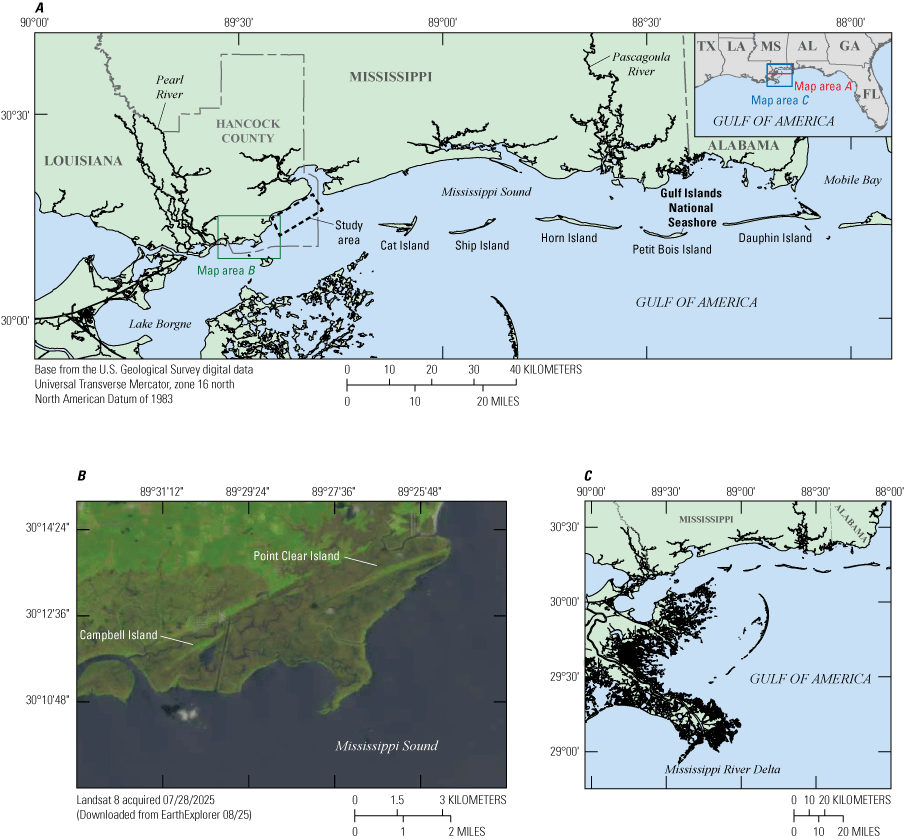
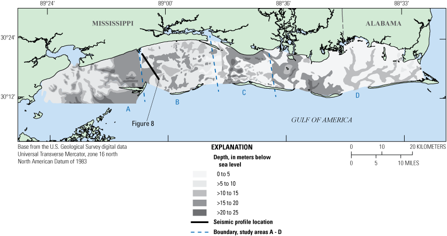
A. Map showing the Mississippi Sound and surrounding features discussed in this study. The study area where sediment deposits are identified and evaluated is shown just offshore of Hancock County, Mississippi. B. Inset map showing an enlarged view of antecedent barrier island systems preserved on Point Clear Island and Campbell Island. C. Inset map showing the Mississippi River Delta located south of the study area.
Other than tidal and shipping channels, the bathymetry within the Mississippi Sound is shallow, with water depths typically less than 5 meters (m) (fig. 2). The water is generally brackish (Priddy and others, 1955), with freshwater supplied to the sound from major waterways such as the Pascagoula and Pearl Rivers (fig. 1). The critical blend of freshwater and saltwater within the sound creates a diverse and ecologically rich environment that supports a wide variety of marine life. Important aquaculture operations include shrimp and oyster harvesting, and the sound supports marine industries such as commercial/recreational fishing and maritime shipping.
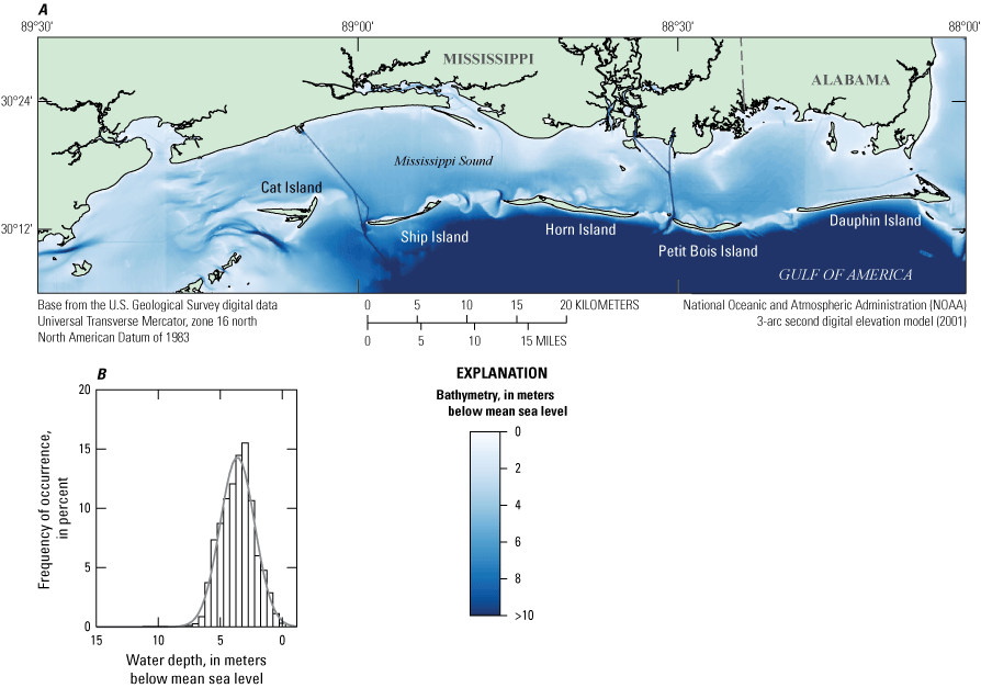
A. Map showing a digital elevation model of the Mississippi Sound and surrounding area, with water depths and land elevations provided. B. Inset graph showing the frequency of occurrence by depth of 5-meter cells within the sound, indicating that 80 percent of the sound is less than 5 meters deep.
The geology of the Mississippi Sound region is influenced by a complex interplay of sea-level fluctuations, fluvial and deltaic processes, and barrier island evolution. The present-day morphology of the sound reflects a geologic history that extends back to the Pleistocene, when sea-level fluctuations drove fluvial processes that both eroded and deposited sediments across the region. The modern barrier islands (fig. 1) developed toward the end of the last sea-level transgression (Otvos, 2001). These islands provide critical habitat for the diverse flora and fauna of the area.
The stratigraphy offshore of Hancock County, Mississippi (fig. 1), reflects the dynamic evolution of the sound and barrier island systems. Using high-resolution single channel seismic profiles (HRSPs) and sediment vibracore data, the U.S. Geological Survey (USGS) in cooperation with the U.S. Army Corps of Engineers (USACE), identified numerous features below the modern seafloor that are related to fluvial and tidal processes occurring during the last 5,000 years. For this study, seismic descriptions and core interpretations were analyzed for these features, where available. Deposits that provide the potential for sediment resources (for example, sand for coastal nourishment) were mapped for spatial extent and volume. Lastly, a coring strategy is provided to further investigate these features to determine their sedimentary characteristics.
The Mississippi Sound faces environmental challenges such as water-quality issues, habitat degradation, erosion, and the impact of sea-level rise and climate change (La Peyre and others, 2014; Morgan and Rakocinski, 2022). Efforts to protect and restore the sound's ecosystem are crucial to preserving its ecological and economic value for the region. Understanding the geology is crucial for informing coastal management decisions, hazard assessment and mitigation, and identifying potential mineral resources. The literature review completed for this study aims to provide a comprehensive overview of the geology of the Mississippi Sound by synthesizing existing research and data to identify morphologic features and processes.
Purpose and Scope
This report documents the shallow geologic framework of the Mississippi Sound and the potential for sediment resources. The literature review herein provides an outline of the Pleistocene and Holocene geology, the evolution of the Mississippi barrier islands, and the marine habitats and morphologic features within the sound. Existing reports and scientific journal articles pertaining to the geology, morphology, geography, physical processes (sediment transport, hydrology, oceanography), management, physical assessment (sediment type, biology), and habitat associated with the Mississippi Sound are provided in appendix 1. Geologic data, such as seismic data, sediment cores, and structure and elevation maps, are also identified and synthesized.
Methodology
To compile existing literature specific to the study area, search resources from the USGS library catalog were used, and more than 80 articles were identified. For each article, a list of keywords that summarize content was created and is provided in text format in appendix 1.
All HRSP data holdings acquired within the Mississippi Sound and archived by the USGS in St. Petersburg, Florida, are shown in figure 3. This dataset contains seismic data collected from 1980 to 2010 in various analog (paper prints) and digital (image) formats. The analog HRSP, formerly “boomer” data archived as paper rolls and fan-folds, has been converted to digital format, and both the former analog and existing digital data have been published in USGS series publications and data releases (Sanford and others, 2009; Forde and others, 2011a, b, 2012; Bosse and others, 2017).
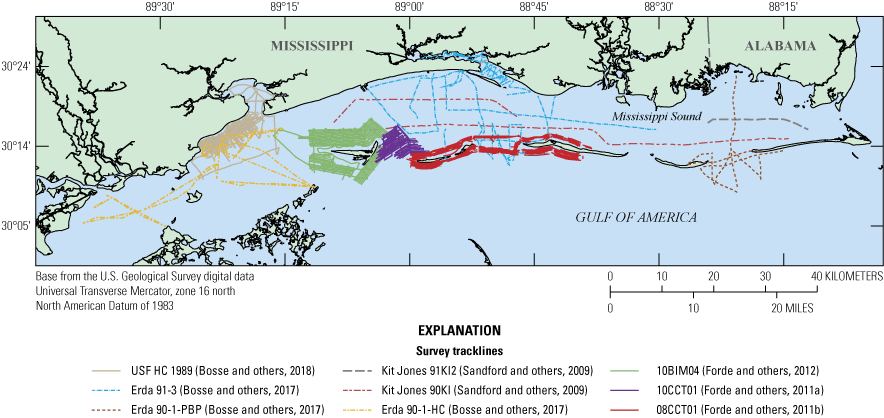
Map showing location of high-resolution single channel seismic profile data collected in the Mississippi Sound between 1980 and 2010 and archived by the U.S. Geological Survey at St. Petersburg, Florida. Data from Sanford and others (2009), Forde and others (2011a, b, 2012), Bosse and others (2017, 2018).
A key geologic horizon within the sound, the Pleistocene-Holocene surface is relevant to regional morphologic evolution and sediment resource assessment. This unconformable surface is traceable continuously in subbottom profiles across the region and represents the last sea-level lowstand. It has been identified and mapped in four previous studies (Hollis, 2018; Adcock, 2019; Gal and others, 2021; Peoples, 2022). For this study, a regional Pleistocene surface was integrated from these efforts and is discussed in the following section.
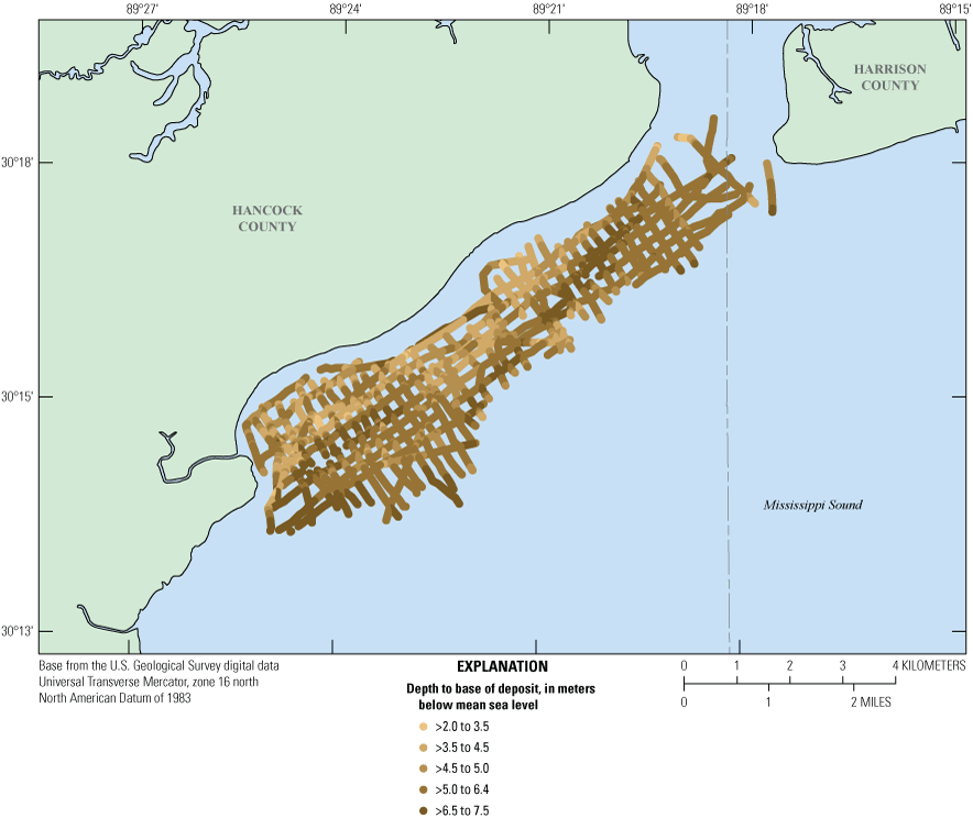
Offshore of Hancock County in the northwestern area of the Mississippi Sound (fig. 4), HRSP data were used to identify the acoustic stratigraphy. Approximately 225-line km of HRSP data were scanned from paper copies archived at the USGS in St. Petersburg, Fla., converted to industry standard Society of Exploration Geophysicists Y Format (SEG-Y) (Barry and others, 1975), and published as a USGS data release (Bosse and others, 2018). For this study, the data were entered into seismic-data interpretation software (OpendTect version 7.0, https://dgbes.com), along with the National Oceanic and Atmospheric Administration’s National Geophysical Data Center (NGDC) bathymetric digital elevation model (NGDC, 2010), to develop a three-dimensional visualization cube (fig. 5). The HRSP lines were resampled to the bathymetric grid to align the lines to a common vertical datum, specifically the North American Vertical Datum of 1988 (NAVD 88). To ground truth the geophysical data, 81 sediment vibracore and 12 penetrometer logs from within the survey area were recovered from USACE archives and analyzed for use in this study. These logs contain descriptions of stratigraphic units within the upper 9 m of sediment (fig. 6). The depths to the tops of these units were digitized and entered into the visualization cube using the spatial information included in the logs. This process allows for direct correlation of acoustic horizons captured in the seismic data to stratigraphic information derived from the vibracore data.
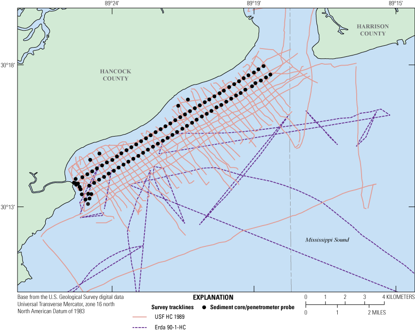
Map showing high-resolution single channel seismic profile tracklines acquired in the Mississippi Sound, offshore of Hancock County, Mississippi, during the USF HC 1989 (Bosse and others, 2018) and Erda 90-1-HC (Bosse and others, 2017) cruises. Sediment vibracores and penetrometer probes collected within the study area were acquired from U.S. Army Corps of Engineers archives (Schmid, 2001). See figure 3 for regional trackline location.
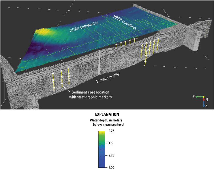
Schematic diagram showing the data cube within the OpendTect software visualization environment. The high-resolution single channel seismic profiles (HRSPs) (Bosse and others, 2018) are integrated in three-dimensional space with a National Oceanic and Atmospheric Administration (NOAA) National Geophysical Data Center (NGDC) digital elevation model (NGDC [2010], shown as a spectral overlay) and the stratigraphic marker depths (white discs) from the sediment vibracore logs.
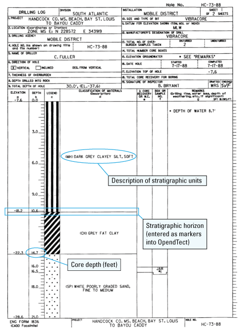
Digitized page of engineering log from the vibracore dataset used in this study (Schmid, 2001). The logs contain descriptive information about the core (for example, location and elevation), and describe stratigraphic units by texture (for example, dark grey clayey silt) relative to depth below the seafloor. Spatial data are included in the logs; the spatial data and depth to stratigraphic horizons were digitized and entered into the OpendTect seismic interpretation software.
To properly correlate stratigraphic depths from the core logs to the two-way travel time (TWTT) of acoustic horizons in the HRSP, a velocity analysis was performed on the data where the HRSP overlapped with the core data. It was assumed that a contrast in lithology produces a sharp reflector (significant impedance in the acoustic data displays as an amplitude peak) across the density gradient, in this case the transition from clay to sand, and that the corresponding depth in TWTT and depth to the stratigraphic horizon, in meters, can be used to calculate the sound velocity of the acoustic signal within the sediments. This velocity was used to correlate the HRSPs to the sediment cores. A strong acoustic horizon in the HRSP was identified that correlated to a specific stratigraphic horizon in the core logs (in this case, the transition from a clay unit to a sand unit occurring 3–6 m below the seafloor [mbsf]). The comparison of depth to the acoustic reflector and depth to the stratigraphic horizon between the HRSP and sediment cores is shown in table 1.
Table 1.
Comparison between depth to a well-defined acoustic horizon in high-resolution single channel seismic profiles (HRSPs) (Bosse and others, 2018) and stratigraphic horizons in sediment cores (Schmid, 2001).[It is assumed that a contrast in lithology produces a sharp reflector across the density gradient, in this case the transition from clay to sand, and that the corresponding depth in two-way travel time (TWTT) and depth to the stratigraphic horizon, in meters, can be used to calculate the sound velocity of the acoustic signal within the sediments. This velocity is used to correlate the HRSP to the sediment cores. ID, identification; no., number; ms, millisecond; and mbsl, meters below sea level]
The TWTT to the reflector for 20 instances was graphed versus the depth of the stratigraphic horizon relative to sound source, which is positioned at the water surface. The cross-plot (fig. 7) produces a best-fit second-order polynomial curve that was used to calculate depth in TWTT, in milliseconds, for depth intervals in 1-m increments over the range of target depths (3–6 mbsf). Using the curve fit to the data rather than direct comparisons reduces water-column sound velocity artifacts and temporal level variations from the downcore depth correlation. The resulting velocities for each depth interval range from 1,161 to 2,471 meters per second (m/s), which are comparable to the expected range (1,491–1,836 m/s) for marine sediments (Hamilton, 1971). The average value of the range (1,878 m/s) was assumed to be the best-fit sound velocity for the sediment column. This velocity was then applied to the stratigraphic depth of the markers that have been entered into the visualization software for correlation with the HRSP.
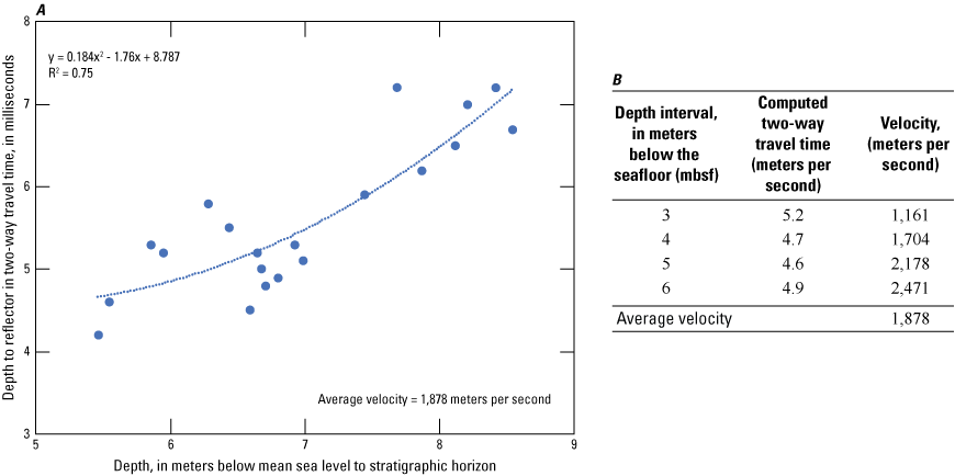
Graph showing velocity analysis used to correlate marker depth from the core logs (Schmid, 2001) to two-way travel time (TWTT) in the high-resolution single channel seismic profile (Bosse and others, 2018). A second-order polynomial fit was applied to, A, a cross-plot of acoustic versus stratigraphic horizons. The resulting curve solution was used in, B, the associated table to convert depth, in meters below the seafloor (mbsf), within the correlation range (3–6 meters) to sound velocity in 1-meter increments. The average from the velocity model (1,878 meters per second) was then used in the visualization software to adjust core depth stratigraphic markers provided in mbsf to TWTT.
Once the HRSP and core data were properly aligned in the visualization software, the data were interpreted to characterize the geologic framework within the study area. Where the sediment core data overlapped the HRSP, sedimentary texture was inferred to continue along the profile to the extent of the acoustic horizon. As subsurface sediment deposits were identified, their spatial distribution was mapped and extracted for volumetric analysis. These features are discussed in the analysis section of this study.
Geology of the Mississippi Sound
Pleistocene Deposits
The oldest shallow (< 50 m) stratigraphy in the Mississippi Sound is a series of transgressive and regressive sequences associated with Pleistocene sea-level fluctuations in response to glacial cycles (Anderson and others, 2016; Peoples, 2022). During interglacial periods, when sea level was near its present position, sediments associated with estuarine, deltaic, and shallow marine environments formed the coastal terraces throughout the region (Heinrich, 2006), and deltaic deposits from ancestral rivers infilled areas of the present-day sound. As sea level dropped during glacial periods, these deposits were incised by fluvial systems that meandered across exposed areas of the inner shelf, forming river valleys (Kindinger and others, 1994). As subsequent sea-level rise flooded the region, these deposits were eroded and reworked into expansive sand sheets. The river embayments filled with sediment as bayhead deltas retreated upstream (Bart and Anderson, 2004). When these interglacial and glacial-period deposits are viewed in a seismic profile, the incised valleys form distinct features that are characterized as dipping or chaotic reflectors within a sequence boundary reflector that represents the previous regressive surface (Flocks and others, 2015). The infill deposits are a combination of fluvial channel sands or muds associated with estuarine deposits (Hollis, 2018).
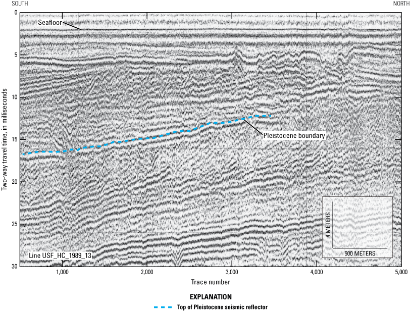
The stratigraphic surface representing the last sea-level lowstand is described in sediment cores as a stiff, oxidized medium gray to orange clay. The oxidized nature is indicative of subaerial exposure during lowstand conditions (Greene and others, 2007). This surface marks the transition from the Pleistocene to Holocene and is readily mapped in seismic profiles (fig. 8). Four studies have mapped the upper surface of the Pleistocene within the sound (Hollis, 2018; Adcock, 2019; Gal and others, 2021; Peoples, 2022). A compilation of the Pleistocene surface mapped in these studies is shown in figure 9. The surface deepens from east to west and seaward and it exhibits a dendritic appearance typical of fluvial systems. Sediments above this horizon represent marine-transgressive and backstepping fluvial depositional processes that occurred during the Holocene.
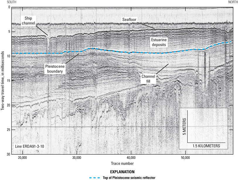
High-resolution single channel seismic profile (ERDA91-3-10) from the Mississippi Sound. The vertical axis represents profile depth below sea level in terms of time, and the horizontal axis is distance represented by consecutive traces. The profile shows the reflector representing the Pleistocene boundary. Deposits below this horizon include fluvial valley fill, and those above it are composed of Holocene fluvial and estuarine sediments. Location of profile is shown in figure 9.
Map showing depth to the Pleistocene surface reconstructed from four studies of the Quaternary stratigraphy in the Mississippi Sound, with individual study areas separated by dashed lines. The surface is identified as the (A) Pleistocene-Holocene unconformity in Adcock (2019), (B) paleochannel depth in Peoples (2022), (C) MIS 2 sequence boundary in Gal and others (2021), and (D) MIS 2 lowstand sequence boundary in Hollis (2018).
Holocene Deposits
Sea-level rise during the Holocene eroded the Pleistocene interfluve areas, creating a disconformity between the Pleistocene sequence boundary and subsequent marine deposits. As the Mississippi Sound embayment was initiated, transgressive deposits infilled the Pleistocene paleovalleys. When sea level neared the present position, 4–6 m of marine sands and muds (estuarine deposits in fig. 8) had been deposited within the area of the present-day sound (Twichell and others, 2013). The reworking of these marine deposits formed the first of the Mississippi Barrier Islands around 5,500 years ago (Otvos and Giardino, 2004). To the east, sediment transport from Dauphin Island and a feature known locally as the “Mobile Pass ebb-tide delta” provided sandy sediments for the evolving barrier island system. Recent studies indicate that the barrier islands formed along a change in gradient in a former Pleistocene lowstand sequence boundary (Hollis, 2018) and that recurring tidal inlets between the islands correlate with the positions of former Pleistocene fluvial valleys (Flocks and others, 2015; Gal and others, 2021). Although the current barrier island configuration is relatively young, remnants of earlier barrier island systems, such as Point Clear Island and Campbell Island, remain stranded within mainland estuaries along the Mississippi coast (Otvos, 2001).
To the west, progradation of the Mississippi River Delta influenced sediment transport across the sound. Delta lobes from the St. Bernard delta complex of the Mississippi River transgressed into the western sound and Lake Borgne areas between 4 and 2 kilo-annum (ka) (Frazier, 1967; Otvos and Giardino, 2004). These lobes introduced fine-grained sediments (for example, clays) into the system, which had formerly been dominated by active barrier island development (for example, sands). The change from an open embayment to delta marsh environment reduced wave energy and promoted marsh expansion around the barrier islands that had been developing along the mainland shoreline. Mainland adjacent islands, such as Point Clear Island, were stranded within the newly formed estuarine environment. Offshore, the T-shape of Cat Island (fig. 1) reflects this diversion in wave energy and reduced sediment supply that restructured sediment transport directions at the island (Otvos and Giardino, 2004).
The present-day Mississippi Sound is defined by the barrier island system that flanks the seaward side. The barrier islands range in length from approximately 2 to 20 km and are less than 2 km wide (fig. 2). The islands are highly dynamic; storm-induced breaching and island reconfiguration are commonly observed (Morton, 2008). Some of the breaches have evolved into tidal inlets, and tidal flow through the inlets has developed expansive flood-tidal deltas that introduce sandy sediments to the otherwise muddy estuarine deposits of the sound. An analysis of surface sediments (Upshaw and others, 1966) shows sandier sediments distributed along the barrier islands, whereas the majority of sediments within the sound are composed of silts and clays (fig. 10). The morphology of the northern (mainland) shoreline is composed of a mixture of microtidal estuaries, tidal marsh, and pocket bays (Greene and others, 2007), with remnant barrier islands immediately offshore or drowned within the marsh environment (Otvos and Giardino, 2004).
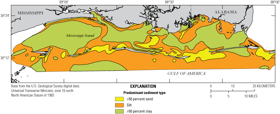
Sediment distribution map showing overall texture of surface sediments, reconstructed from entropy-ratio data in Upshaw and others (1966). Grain size was determined using mechanical sieving of grab samples collected across the Mississippi Sound and offshore.
Shallow-water seagrass beds are present on the sound side of the barrier islands and along the mainland shoreline. Areas along the northern shore with harder substrates provide attachment for oyster reefs, and freshwater flow from rivers is an important contributor to reef development. The main rivers entering the sound, the Pascagoula River to the east and Pearl River to the west (fig. 1), introduce freshwater and provide nutrients for oyster development. Along with the seagrass beds and oyster reefs, sandy shorelines, such as Hancock County beach in Mississippi, provide mainland protection from storms and sea-level rise. This shoreline is experiencing erosion at a rate of about 7,600 cubic meters (m3) per year and requires regular renourishments of sand from borrow pits immediately offshore (Schmid, 2002). Sand is a finite resource, and identifying areas of potential sandy deposits for future coastal restoration is a continuing challenge. The following section of this report characterizes geologic features offshore of Hancock County in the context of potential sand-rich sediment resources.
Potential Sediment Resources of Hancock County, Mississippi
Analysis
Offshore of Hancock County, the acoustic stratigraphy was interpreted from approximately 125-line km of HRSP (fig. 4) to identify sediment deposits. The HRSP within the study area represents the top 100 m of stratigraphy, and distinct sedimentologic features are interpreted and mapped by following the subsurface horizons that persist throughout the seismic profiles. Within the Mississippi Sound region, these features are associated with buried fluvial channels, marine-transgressive deposits, and tidal deposits (Twichell and others, 2011; Miselis and others, 2014; Flocks and others, 2015). To ground truth the sedimentologic composition represented by the reflectors, direct sampling of the stratigraphy using borings and sediment cores is necessary. Within the study area, 93 vibracores and penetrometer logs were identified from the digital archives of the USACE (fig. 4). The cores were collected adjacent to the shoreline, and their distribution does not extend offshore where the majority of the HSRPs were collected. Where core data interpretations are correlated with the acoustic horizons in seismic profiles, the stratigraphic horizon can be spatially expanded using the latter. However, where acoustic facies did not have stratigraphic correlation, only assumptions about the nature of the stratigraphy could be made. In this study, four distinct sedimentologic deposits and one horizon (fig. 11) were mapped and are discussed in the following section.
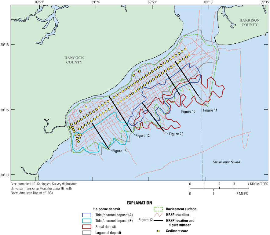
Map of the Mississippi Sound adjacent to Hancock County displaying high-resolution single channel seismic profile (HRSP) coverage and four specific Holocene deposits identified above the Pleistocene boundary (ravinement surface). Location of seismic profiles shown in other figures indicated on map.
Pleistocene Seismic Horizon
Throughout the study area, an acoustic reflector that shallows landward (south to north, fig. 12) is identified and mapped in all of the HRSPs. Depths to this flooding surface (ravinement), in meters below the sound-source which resides at sea level, range from 2.25 m nearshore to over 7 m offshore (fig. 13). No cores penetrate this horizon, but the depth of the reflector correlates with the Pleistocene stratigraphy observed throughout the Mississippi Sound (figs. 8–9). The strength and persistence of the return signal suggests the horizon represents a ravinement surface within the Pleistocene, possibly the top of the Prairie Formation (Otvos, 2001; Heinrich, 2006). The stratigraphy above this horizon would correspond to sediments deposited at the end of the Pleistocene and throughout the Holocene.
High-resolution single channel seismic profile (USF_HC_1989_13) showing the location of the acoustic reflector that represents the Pleistocene ravinement surface. Location of profile is shown in figure 11.
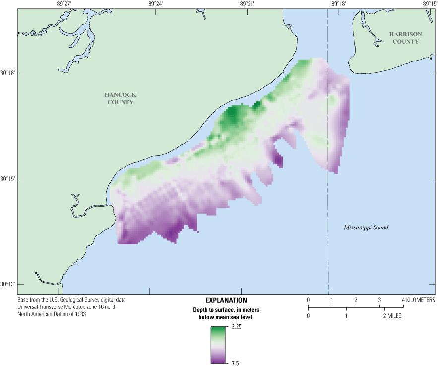
Map showing depth to the acoustic reflector that represents the Pleistocene ravinement surface.
Holocene Lagoon Deposits
The predominant deposits within the study area are estuarine muds that accumulated within the Mississippi Sound throughout the Holocene. As the Mississippi River prograded into the area from the west to form the St. Bernard delta complex, it not only deposited thick sequences of prodelta muds (Twichell and others, 2011) but also formed a morphological transition from an open embayment to lagoonal environment. The decrease in current energy was coupled with a decrease in sand supply from the barrier island chain to the east (Otvos, 2001). Silts and clays from the fluvial systems to the north and marine muds transported by tidal currents from the Gulf of America became the dominant deposits within the sound. Sediments collected from this environment are described in the USACE vibracore logs as dark gray silty clay (fig. 6). In the seismic profiles, the lagoonal deposit is generally characterized by weak horizontal reflectors infilling a strong basal reflector (fig. 14). Depth to this basal horizon is variable but generally deepens seaward and to the southwest (fig. 15).
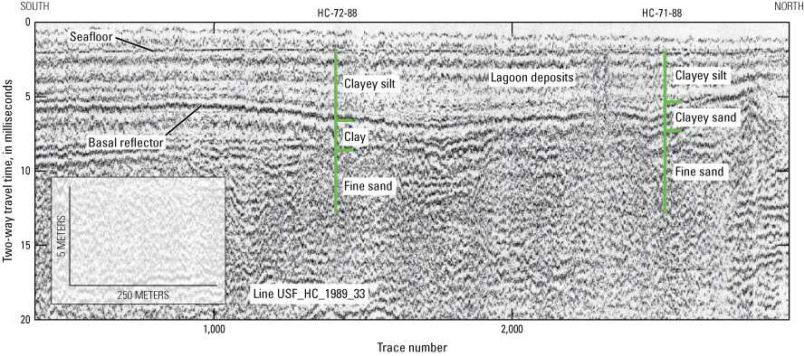
High-resolution single channel seismic profile (USF_HC_1989_33) showing the horizontal acoustic reflectors that represent lagoonal deposits. Two sediment cores (HC-72-88 and HC-71-88) acquired along the profile contain clays and silts and rest on top of fine sand. The depth to the base of the deposits (base reflector) is shown in figure 15. Location of profile is shown in figure 11.
Map showing the depth to the base of the lagoonal deposits (basal reflector in fig. 14).
Fluvial Channel and Tidal Deposits (A and B)
Two features in the offshore portion of the study area (deposits A and B in fig. 11) have acoustic reflectors that resemble deposits found throughout the northern Gulf of America and were formed through fluvial or tidal processes. Parallel acoustic reflectors that are either horizontal or dipping represent fluvial valley fill, tidal deltas, or tidal inlet fill (Twichell and others, 2011; Miselis and others, 2014; Flocks and others, 2015). Without direct sampling through sediment cores, it is often not possible to determine the exact provenance of these features, but all are formed through current activity, either tidal or fluvial driven. These high-energy current processes typically move and deposit sand, although fluvial channel fill can commonly contain muds as well.
The first feature (deposit A in fig. 11) has the acoustic characteristics of a buried fluvial channel, with down-dipping reflectors forming a channel base, overlain by “infilling” horizontal reflectors (fig. 16). The chaotic pattern at the thalweg of the channel represents biogenic gas accumulation, which attenuates the acoustic return and obscures any underlying stratigraphy, a common occurrence in buried fluvial channels. During the last sea-level lowstand, fluvial channels entrenched the inner shelf (Kindinger and others, 1994; Hollis, 2018; Gal and others, 2021). As sea level rose, the channels were infilled with bayhead delta and marine deposits. No sediment cores penetrate this deposit, and direct sampling is necessary to determine the texture of the infill. The feature generally trends northeast-southwest across the study area and is mapped across consecutive HRSP lines. An isopach map of the deposit (fig. 17) shows the concave nature, with up to 9 m of channel fill within the center and thinning toward the flanks.
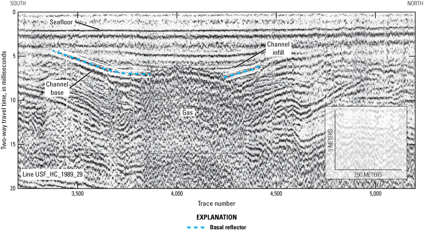
High-resolution single channel seismic profile (USF_HC_1989_29) showing the cross-section of the possible fluvial channel feature within the study area. The basal reflector along the flanks of the feature dips down toward the center, which has an accumulation of gas at the thalweg. Profile and deposit A location shown in figure 11.
Map showing Isopach derived from interpretation and gridding of deposit A (channel fill) basal surface (shown in fig. 16). The thickness and spatial extent show the linear and concave channel-like nature of the feature.
The second feature (deposit B in fig. 11) is characterized by acoustic reflectors down-lapping in an offshore, southerly direction (fig. 18). The deposit extends beyond the HRSP coverage; consequently, the total spatial extent of this unit is unknown. The acoustic pattern of this feature is consistent with tidal deposits seen elsewhere across the Gulf of America shelf (Twichell and others, 2011). Although no vibracores were collected within this deposit, four penetrometer logs were acquired along the western edge (fig. 11). The penetrometer probe met refusal at 4 mbsf, where it encountered a fine white sand; this depth below the seafloor likely corresponds to the top of the tidal deposit. An isopach map of deposit B (fig. 19) indicates that, within the study area, the deposit thickens up to 5 m offshore with a volume of 8.5×10⁶ m3.
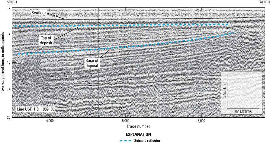
High-resolution single channel seismic profile (USF_HC_1989_05) showing thinly laminated, parallel reflectors dipping downward offshore (toward the south). Penetrometer probes met refusal at the top of this deposit and samples acquired consisted of fine sand. Location of profile is shown in figure 11.
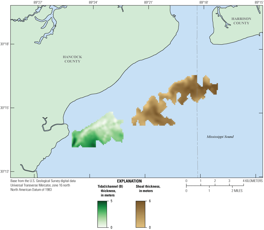
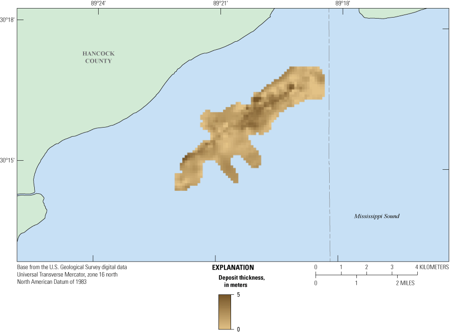
Isopachs of the possible tidal deposit B and the shoal deposit (locations shown in fig. 11). Deposit B thickens seaward, and the shoal deposit thickens toward the center of the feature.
Shoal Deposit
At the seaward edge of the study area, there is a deposit that resembles, in shape, a remnant barrier or shoal system (fig. 11). The acoustic signature is consistent with shoal deposits identified in the northern Gulf of America (Twichell and others, 2011; Kindinger and others, 2014), with distinct bottom and top reflectors, and chaotic or massive interior reflectors (fig. 20). No sediment cores were acquired from the deposit, so the stratigraphy can only be assumed from the chaotic nature of the seismic signal observed within the HRSP. A similar deposit was identified between the study area and Cat Island to the southeast. The deposit, described as light olive-brown sand with shell fragments (North Upper Sand deposit in Kindinger and others, 2014), contains over 92 percent fine- to medium-grained sand. Both features align with the strandplain ridges along the Hancock County shoreline and Cat Island offshore; the alignment suggests they could be submerged island remnants postulated in Otvos and Giardino (2004). The thickness of the deposit exceeds 5 m at the crest (fig. 19), with a study-area volume of 12.3×10⁶ m3.
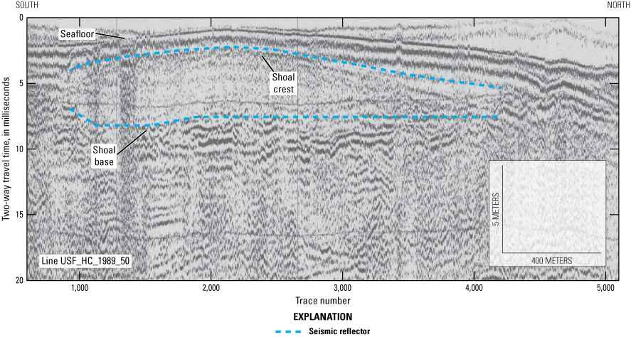
High-resolution single channel seismic profile (USF_HC_1989_50) showing possible island remnant or shoal feature within the study area. The deposit is crest-shaped and contains chaotic acoustic reflectors indicative of massive sand deposits up to 5 meters thick (see fig. 19 for isopach map). Location of profile is shown in figure 11.
Proposed Reconnaissance Coring Strategy to Ground Truth the HRSP
The three deposits identified in this study that have potential as sediment resources for shoreline restoration include the possible fluvial channel (figs. 16–17), tidal (figs. 18–19), and shoal deposits (figs. 19–20). The spatial and volumetric extents of these features determined in this study are shown in table 2. To ground truth the seismic reflection interpretations and assign sediment types to the seismic stratigraphy, direct sampling of the sediments is necessary. To identify shallow geologic and seafloor morphologic features in marine environments, 9-m-long sediment cores are commonly collected using a vibratory system (vibracore). Analysis of vibracores can include visual interpretation, sediment grain size measurements, and other analytic procedures that provide data and insight into the sedimentology of the samples collected and the stratigraphy. Seismic reflectors represent changes in density between lithologic units (for example, a transition from sand to silt) and are correlated with stratigraphic horizons. Once the seismic reflectors have been correlated to the sedimentology and stratigraphy in a vibracore or vibracores, the stratigraphic units can then be extrapolated across the study area using the HRSP.
Table 2.
Spatial and volumetric extents of potential sand-resource deposits identified in this study.[ID, identification; m2, square meter; m, meter; m3, cubic meter]
For features within the study area to be considered a viable sediment resource, the deposit must be at or near the seafloor. For this study, a minimal overburden (less than 3 m) of nonsuitable sediments (for example, silts and clays) was used to optimize sediment recovery. In the Mississippi Sound, the overburden is considered to be lagoonal or estuarine muds. The deposits that best fit these criteria are the tidal deposit (B) and the shoal deposit (fig. 11). The possible fluvial deposit (A) may contain suitable sand; however, it may have significant overburden, making it a less viable source (table 2). The proposed coring strategy is broad and at a reconnaissance level, with cores centered on the HRSP to provide ground truthing for the seismic reflectors. The intent of the exploratory coring is not to provide the high-resolution stratigraphic characterization necessary for engineering and designing borrow sites, but rather to investigate large-scale features that can be delineated using HRSPs. Table 3 lists the proposed core sites with relevant information about each site, the target deposit, and the HRSP used to select the location. Thickness values for the sediment deposit were extracted from the isopach maps (figs. 17 and 19) at each potential vibracore site. Figure 21 shows the potential core site selections in map view based on the resource criteria, as discussed, targeting the fluvial/tidal features (A and B), and the shoal deposit.
Table 3.
Proposed core sites to provide textural information of the targeted deposits along the high-resolution single channel seismic profile (HRSP).[The relevant information includes site coordinates, water depth (meters) at the core site extracted from the National Oceanic and Atmospheric Administration Digital Elevation Model (fig. 2), the target deposit and thickness at the core site, and the closest HRSP to the site (Bosse and others, 2018). ID, identification; UTM, Universal Transverse Mercator; m, meter; NAD 83, North American Datum of 1983]
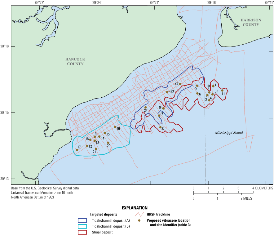
Map showing proposed core site locations to provide textural information of the targeted deposits along the high-resolution single channel seismic profiles (HRSPs). Core site numbers correspond to the statistics shown in table 3.
Conclusion
The Mississippi Sound is a microtidal estuary located between the central gulf coast mainland and the Gulf of America. The sound is separated from the open ocean by a barrier island system with large inlets that allow tidal flow and sediment exchange between the gulf and sound. Rivers such as the Pearl and Pascagoula provide freshwater from the mainland to maintain a brackish water environment in the sound.
The physical environment of the Mississippi Sound has been shaped by fluvial and marine-transgressive processes that have occurred across the northern gulf since the Pleistocene. Former fluvial channels infilled with sediment during the last sea-level rise, while interfluve areas were eroded and incised by rivers. Dynamic sediment transport processes formed the present barrier island system, while delta lobe progradation from the Mississippi River Delta to the west restricted island development and enhanced marsh and estuarine evolution.
The sediments dispersed across the seafloor of the Mississippi Sound reflect the Holocene history, with muds accumulating across most of the sound and sandy deposits accumulating along the barrier island platform and tidal deltas. Barrier island systems and shoals that developed early in the Holocene are buried within the sound, and sand associated with the dynamic sediment processes indicative of their evolution (for example, fluvial and tidal flow) are retained in the shallow stratigraphy below the seafloor. Data from geophysical surveys and sediment cores were used to identify three deposits and evaluate their spatial extent, volume, and depth below seafloor. Lastly, the study outlined a sediment-coring strategy to further define these features.
References Cited
Adcock, D., 2019, Stratigraphic characterization of the Pleistocene paleodrainage network in the western Mississippi Sound: Starkville, Mississippi, Mississippi State University, Department of Geosciences, Theses and Dissertations 4073, 96 p., accessed February 21, 2024, at https://scholarsjunction.msstate.edu/td/4073.
Anderson, J., Wallace, D., Simms, A., Rodriguez, A., Weight, R., and Taha, Z., 2016, Recycling sediments between source and sink during a eustatic cycle—Case study of late Quaternary northwestern Gulf of Mexico Basin: Earth-Science Reviews, v. 153, p. 111–138, accessed March 6, 2024, at https://doi.org/10.1016/j.earscirev.2015.10.014.
Barry, R.M., Cavers, D.A., and Kneale, C.W., 1975, Recommended standards for digital tape formats: Geophysics, v. 40, no. 2, p. 344–352. [Also available at https://www.seg.org/publications/tech-stand.]
Bart, P., and Anderson, J., 2004, Late Quaternary stratigraphic evolution of the Alabama and west Florida outer continental shelf: Society for Sedimentary Geology Special Publication no. 79, p. 43–53, accessed February 14, 2024, at http://www.geol.lsu.edu/bart/bart/Bio_files/Bart%20and%20Anderson%202004.pdf.
Bosse, S., Flocks, J., and Forde, A., 2017, Digitized analog boomer seismic-reflection data collected during U.S. Geological Survey cruises Erda 90-1_HC, Erda 90-1_PBP, and Erda 91-3 in Mississippi Sound, June 1990 and September 1991: U.S. Geological Survey Data Series 1047, accessed February 14, 2024, at https://doi.org/10.3133/ds1047.
Bosse, S., Flocks, J., and Forde, A., 2018, Archive of digitized analog boomer seismic reflection data collected during USGS cruise USFHC in Mississippi Sound and Bay St. Louis, September 1989: U.S. Geological Survey data release, accessed February 14, 2024, at https://doi.org/10.5066/F7J67G5B.
Flocks, J., Kindinger, J., and Kelso, K., 2015, Geologic control on the evolution of the inner shelf morphology offshore of the Mississippi barrier islands, northern Gulf of Mexico, USA: Continental Shelf Research, v. 101, p. 59–70, accessed March 6, 2024, at https://doi.org/10.1016/j.csr.2015.04.008.
Forde, A., Dadisman, S., Flocks, J., Wiese, D., DeWitt, N., Pfeiffer, W., Kelso, K., and Thompson, P., 2011a, Archive of digital chirp subbottom profile data collected during USGS cruises 10CCT01, 10CCT02, and 10CCT03, Mississippi and Alabama Gulf islands, March and April 2010: U.S. Geological Survey Data Series 611, 11 DVDs, accessed February 14, 2024, at https://pubs.usgs.gov/ds/611/.
Forde, A., Dadisman, S., Flocks, J., and Worley, C., 2011b, Archive of digital chirp subbottom profile data collected during USGS cruise 08CCT01, Mississippi Gulf islands, July 2008: U.S. Geological Survey Data Series 620, 5 DVDs, accessed February 14, 2024, at https://pubs.usgs.gov/ds/620/.
Forde, A., Dadisman, S., Kindinger, J., Miselis, J., Wiese, D., and Buster, N., 2012, Archive of digital chirp subbottom profile data collected during USGS cruise 10BIM04 offshore Cat Island, Mississippi, September 2010: U.S. Geological Survey Data Series 724, 2 DVDs, accessed February 14, 2024, at https://pubs.usgs.gov/ds/724/.
Frazier, D., 1967, Recent deltaic deposits of the Mississippi River—Their development and chronology: Gulf Coast Association of Geological Societies Transactions, v. 17, p. 287–315, accessed February 14, 2024, at https://archives.datapages.com/data/gcags/data/017/017001/0287.htm.
Gal, N., Wallace, D., Miner, M., Hollis, R., Dike, C., and Flocks, J., 2021, Influence of antecedent geology on the Holocene formation and evolution of Horn Island, Mississippi, USA: Marine Geology, v. 431, article 106375, accessed February 14, 2024, at https://doi.org/10.1016/j.margeo.2020.106375.
Greene, D., Rodriguez, A., and Anderson, J., 2007, Seaward-branching coastal-plain and piedmont incised-valley systems through multiple sea-level cycles—Late Quaternary examples from Mobile Bay and Mississippi Sound, U.S.A: Journal of Sedimentary Research, v. 77, no. 2, p. 139–158, accessed March 6, 2024, at https://doi.org/10.2110/jsr.2007.016.
Hamilton, E., 1971, Elastic properties of marine sediments: Journal of Geophysical Research, v. 76, no. 2, p. 579–604, accessed February 16, 2024, at https://doi.org/10.1029/JB076i002p00579.
Hollis, R., 2018, Late Quaternary evolution and stratigraphic framework influence on coastal systems along the north-central Gulf of Mexico, USA: Ocean Springs, Mississippi, University of Southern Mississippi, no. 598, master's thesis, 84 p., accessed February 29, 2024, at https://aquila.usm.edu/masters_theses/598.
Kindinger, J., Balson, P., and Flocks, J., 1994, Stratigraphy of the Mississippi-Alabama shelf and the Mobile River incised valley system, in Dalrymple, R., Boyd, R., and Zaitlin, B., eds., Incised-valley systems—Origin and sedimentary sequences: Tulsa, Oklahoma, Society for Sedimentary Geology, special publication no. 51, p. 83–95, accessed March 6, 2024, at https://doi.org/10.2110/pec.94.12.0083.
Kindinger, J., Miselis, J., and Buster, N., 2014, The shallow stratigraphy and sand resources offshore from Cat Island, Mississippi: U.S. Geological Survey Open-File Report 2014–1070, 74 p., accessed February 29, 2024, at https://doi.org/10.3133/ofr20141070.
La Peyre, M., Furlong, J., Brown, L., Piazza, B., and Brown, K., 2014, Oyster reef restoration in the northern Gulf of Mexico—Extent, methods and outcomes: Ocean and Coastal Management, v. 89, p. 20–28, accessed March 1, 2024, at https://doi.org/10.1016/j.ocecoaman.2013.12.002.
Miselis, J., Buster, N., and Kindinger, J., 2014, Refining the link between the Holocene development of the Mississippi River Delta and the geologic evolution of Cat Island, MS—Implications for delta-associated barrier islands: Marine Geology, v. 355, p. 274–290, accessed March 1, 2024, at https://doi.org/10.1016/j.margeo.2014.05.021.
Morgan, L., and Rakocinski, C., 2022, Predominant factors limiting the recovery of the eastern oyster (Crassostrea virginica) in western Mississippi Sound, USA: Estuarine, Coastal and Shelf Science, v. 264, article 107652, accessed March 1, 2024, at https://doi.org/10.1016/j.ecss.2021.107652.
Morton, R., 2008, Historical changes in the Mississippi-Alabama barrier-island chain and the roles of extreme storms, sea level, and human activities: Journal of Coastal Research, v. 24, no. 6, p. 1587–1600, accessed February 29, 2024, at https://doi.org/10.2112/07-0953.1.
National Geophysical Data Center [NGDC], 2010, Northern Gulf 1 arc-second NAVD 88 Coastal Digital Elevation Model: National Oceanic and Atmospheric Administration National Centers for Environmental Information web page, accessed April 3, 2024, at https://www.ncei.noaa.gov/metadata/geoportal/rest/metadata/item/gov.noaa.ngdc.mgg.dem:720/html.
Otvos, E., 2001, Mississippi coast—Stratigraphy and Quaternary evolution in the northern Gulf Coastal Plain framework, chap. H in Stratigraphic and Paleontologic studies of the Neogene and Quaternary sediments in southern Jackson County, Mississippi: U.S. Geological Survey Open-File Report 01–415–H, 59 p., accessed March 6, 2024, at https://pubs.usgs.gov/of/2001/of01-415/chap8txt.pdf.
Otvos, E., and Giardino, M., 2004, Interlinked barrier chain and delta lobe development, northern Gulf of Mexico: Sedimentary Geology, v. 169, nos. 1–2, p. 47–73, accessed March 6, 2024, at https://doi.org/10.1016/j.sedgeo.2004.04.008.
Sanford, J., Harrison, A., Wiese, D., and Flocks, J., 2009, Archive of digitized analog boomer seismic reflection data collected from the Mississippi-Alabama-Florida shelf during cruises onboard the R/V Kit Jones, June 1990 and July 1991: U.S. Geological Survey Data Series 429, accessed February 2, 2024, at https://doi.org/10.3133/ds429.
Twichell, D., Flocks, J., Pendleton, E., and Baldwin, W., 2013, Geologic controls on regional and local erosion rates of three northern Gulf of Mexico barrier-island systems: Journal of Coastal Research, v. 63, p. 32–45, accessed March 6, 2024, at https://doi.org/10.2112/SI63-004.1.
Twichell, D., Pendleton, E., Baldwin, W., Foster, D., Flocks, J., Kelso, K., DeWitt, N., Pfeiffer, W., Forde, A., Krick, J., and Baehr, J., 2011, The shallow stratigraphy and sand resources offshore of the Mississippi barrier islands: U.S. Geological Survey Open-File Report 2011–1173, 63 p., accessed February 2, 2024, at https://pubs.usgs.gov/of/2011/1173/.
Appendix 1. Literature Associated With the Geology of Mississippi Sound, With Title, Citation, and Keyword Summary
Conversion Factors
International System of Units to U.S. customary units
Datum
Vertical coordinate information is referenced to the North American Vertical Datum of 1988 (NAVD 88).
Horizontal coordinate information is referenced to the North American Datum of 1983 (NAD 83).
Abbreviations
HRSP
high-resolution single channel seismic profile
mbsf
meters below the seafloor
ka
kilo-annum
NAVD 88
North American Vertical Datum of 1988
NGDC
National Geophysical Data Center
SEG-Y
Society of Exploration Geophysicists Y Format
TWTT
two-way travel time
USACE
U.S. Army Corps of Engineers
USGS
U.S. Geological Survey
For more information about this publication, contact
Director, St. Petersburg Coastal and Marine Science Center
U.S. Geological Survey
600 4th Street South
St. Petersburg, FL 33701
For additional information, visit
https://www.usgs.gov/centers/spcmsc
Publishing support provided by
U.S. Geological Survey Science Publishing Network,
Lafayette Publishing Service Center
Disclaimers
Any use of trade, firm, or product names is for descriptive purposes only and does not imply endorsement by the U.S. Government.
Although this information product, for the most part, is in the public domain, it also may contain copyrighted materials as noted in the text. Permission to reproduce copyrighted items must be secured from the copyright owner.
Suggested Citation
Flocks, J., and Forde, A., 2025, Shallow geologic framework of the Mississippi Sound and the potential for sediment resources: U.S. Geological Survey Scientific Investigations Report 2025–5100, 37 p., https://doi.org/10.3133/sir20255100.
ISSN: 2328-0328 (online)
Study Area
| Publication type | Report |
|---|---|
| Publication Subtype | USGS Numbered Series |
| Title | Shallow geologic framework of the Mississippi Sound and the potential for sediment resources |
| Series title | Scientific Investigations Report |
| Series number | 2025-5100 |
| DOI | 10.3133/sir20255100 |
| Publication Date | December 18, 2025 |
| Year Published | 2025 |
| Language | English |
| Publisher | U.S. Geological Survey |
| Publisher location | Reston, VA |
| Contributing office(s) | St. Petersburg Coastal and Marine Science Center |
| Description | Report: viii, 37 p.; Data Release |
| Country | United States |
| State | Louisiana, Mississippi |
| Other Geospatial | Mississippi Sound |
| Online Only (Y/N) | Y |