
|
|
Scientific Investigations Map 2940 |
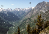
| Qag-2. View west across Swauk Prairie [Wsw], which is underlain by unit Qag: alpine glacial deposits capped by loess. Miocene flood basalt flows of the Grand Ronde Basalt, Yakima Basalt Subgroup, Columbia River Basalt (Tyg) are tilted up to form Lookout Mountain. Massive landslides (QTl) flank uplifted basalt. Qa, alluvium of valley bottom; Qu, alluvium. Contacts dashed where approximately located and dotted where concealed or hidden from view. View image with annotation |

|
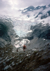
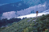
Other photos that show unit Qag:
      |
  |