|
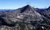
Qt-2. Talus (Qt) above Silver Lake [MBne]. View northeast to crags of the volcanic rocks of Mount Rahm and beyond to the Hozomeen terrane in the Methow block in Canada. The volcanic rocks of the Ohanapecosh episode of the Cascade Magmatic Arc (Tcao) were intruded by a small ~10 m.y. old pluton, the quartz monzodiorite of Redoubt Creek (Cascade Pass family, QTcp, of the Cascade Magmatic arc). Qag, young alpine glacial moraine. Contacts (thin lines) and fault (heavy line) dashed where approximately located and dotted where concealed. View image without annotation
|