|
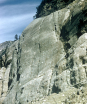
TKcs-3. View south from east ridge of Mount Formidable [SRne]. Rocks of the Chelan Mountains terrane, including Cascade River Schist (TKcs), form foreground cliffs. Underlying metamorphosed Marblemount pluton (TKmd) in Old Guard Peak extends along jagged ridge into middle foreground. Sentinel Peak formed of Napeequa Schist (Kns) is cut by the Entiat Fault. These deep-seated metamorphic rocks were partly uplifted, and overlying rocks were eroded, before they were intruded by the Cloudy Pass batholith, a Miocene Cascade Arc pluton (Tcas) that forms Dome Peak and Spire Point in middle background. Further uplift and erosion, especially glacial erosion, preceded eruption of Glacier Peak volcano (Qcav) of the Cascade Magmatic Arc. Contacts (thin lines) and faults (heavy lines) dashed where approximately located and dotted where hidden in this view. This photo is figure 7 in the accompanying report (sheet 2). Photographed in 1958. View image with annotation
|