U.S. Geological Survey Scientific Investigations Report 2009-5268
Trends in Water Quality in the Southeastern United States, 1973–2005
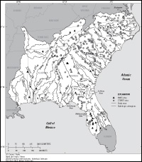
IntroductionThe U.S. Geological Survey (USGS) has reviewed water-quality trends in streams as part of several programs over the last 35 years. The National Stream Quality Accounting Network (NASQAN) Program (Hooper and others, 1997), the Hydrologic Benchmark Network (Buell and Grams, 1985), the National Water-Quality Assessment (NAWQA) Program (Hamilton and others, 2004), and cooperative studies with State agencies all have yielded data well suited for trend analysis. However, study objectives, station locations, constituents analyzed, analysis methodologies, laboratory capabilities, and funding of the programs have evolved over time. This evolution adds complexity to the identification of regional trend patterns. The NAWQA Program is the current USGS program designed, in part, to assess water-quality trends (Hamilton and others, 2004). The objectives of the national program also include characterization of the current quality of streams, groundwater, and aquatic ecosystems in major river basins and aquifer systems across the Nation, and studies intended to improve the understanding of the relations of natural and anthropogenic processes to water quality. One of the major river basins of the NAWQA Program is the South Atlantic–Gulf and Tennessee study area, which includes river basins draining into the southern Atlantic Ocean, Gulf of Mexico, and Tennessee River (fig. 1). This report provides results of trend analyses for selected sites in the Southeastern United States, using USGS and U.S. Environmental Protection Agency (USEPA) databases. Purpose and ScopeThe purpose of this report is to review previous trend results for the Southeast, summarize the results of trend analysis for the current study, identify regional patterns in the trends, and examine the associations of trends in water quality with trends in landscape, agricultural variables, and atmospheric nitrogen inputs. This report is the companion piece for the online report, “Data used in analyses of trends, and nutrient and suspended-sediment loads for streams in the Southeastern United States, 1973–2005” (Staub and others, 2009). Data from 44 USGS National Water Information System (NWIS) sites with sufficient water-quality data and continuous streamflow record to perform trend tests were reviewed (fig. 1; table 1). Measures of pH, specific conductance, and dissolved oxygen, and concentrations of dissolved solids, suspended sediment, chloride, sodium, sulfate, silica, potassium, carbon, total nitrogen, total ammonia, total ammonia plus organic nitrogen, dissolved nitrite plus nitrate, and total phosphorus in streamwater-quality data from the period 1973–2005 were included in the review. The principal objective of the NWIS data analysis was to identify associations in water-quality trends with landscape variables. USEPA Storage and Retrieval (STORET) database data for an additional 290 sites were tested for trends (fig. 1). The trend analyses of the STORET data were limited to total nitrogen and total phosphorus concentrations principally to provide a regional picture of trends in nutrient concentration.
|

![]() U.S. Department of the Interior |
U.S. Geological Survey
U.S. Department of the Interior |
U.S. Geological Survey
URL: http://
pubsdata.usgs.gov
/pubs/sir/2009/5268/introduction.html
Page Contact Information: USGS Publications Team
Page Last Modified: Thursday, 10-Jan-2013 19:43:51 EST