


The purpose of these interpretive discussions is to provide a perspective on regional- and national-scale variations in element and mineral distributions in soils and their likely causes. The significant spatial variations shown by most elements and minerals can commonly be attributed to geologic sources in underlying parent materials, but other spatial variations seem clearly related to additional factors such as climate, the age of soils, transported source material, and anthropogenic influences. We attempt to distinguish the influence of these various factors on a regional and national scale. Numerous more local features might similarly be related to these same factors, but these features also have some probability of being an artifact of a random sampling of variable compositions, so that there is some probability of samples with similar compositions occurring in clusters of two or more adjacent sites by chance. Distinguishing such random occurrences from true variability is beyond the scope of the data from which these maps are constructed. Some caution, therefore, is advisable in interpreting the significance of these more local features unless some unique sources or processes can clearly be related to them.
Organic carbon (Corg) is that portion of the total carbon contained in soils that is chemically incorporated into soil organic matter. Carbon also occurs in soil inorganic material such as carbonate minerals; that portion of the total carbon is classified as inorganic carbon and is discussed separately. Organic carbon is an essential building block for virtually all organic material. Although somewhat variable, the carbon content of soil organic material is typically about 60 weight percent (wt. %). In this survey, Corg was not analyzed directly, but rather was calculated as the difference between total carbon and inorganic carbon. Because many soil organic compounds are unstable and susceptible to transformations and decomposition over relatively short time periods, the Corg concentration of soils is unusually susceptible to changes caused by a variety of factors such as land use and agricultural practices, and disturbances such as forest fire, in addition to soil–forming processes and parent material composition.
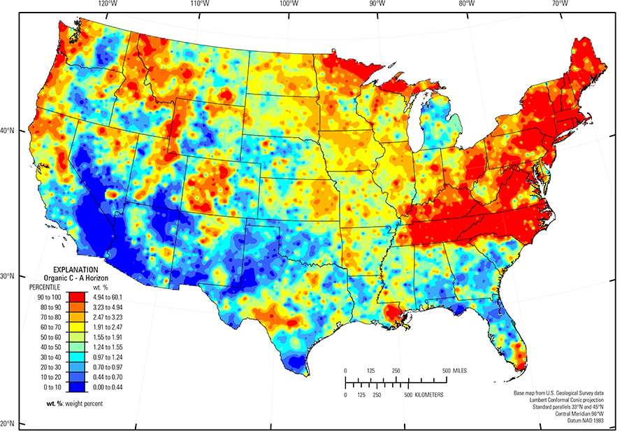
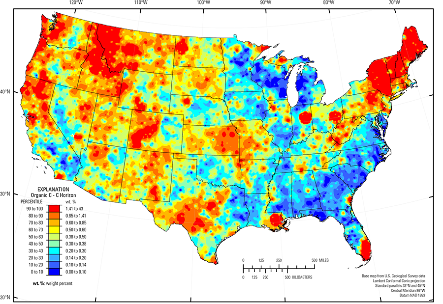
The soil A horizon (median = 1.55 wt. % Corg) is richer in Corg than the soil C horizon (median = 0.38 wt. % Corg) at most sites, because a concentration of organic matter is one of the defining criteria for the soil A horizon (see the summary statistics [open in new window]). Exceptions, comprising about 10 percent of sampled sites, are mostly in the western and southwestern United States in arid and semiarid regions with sparse vegetation and correspondingly low input of organic matter to soils. In these areas, the Corg concentration of both horizons is low. The map of the soil A horizon shows a prominent discontinuity of Corg concentration along State boundaries between Mississippi, Alabama, Georgia, and South Carolina on the south, and Tennessee and North Carolina on the north. This is an artefact of variable sampling caused by different sampling personnel applying different criteria for the base of the A horizon, and thereby producing varying concentrations of Corg across these State boundaries. It is not a real variation in the nature of the soils. This artefact is not present in the soil C horizon map. We did not determine Corg for the samples collected from the top 0- to 5-cm layer.
In the soil C horizon the most Corg–rich soils occur in:
- Mountainous terrains of the Pacific Northwest;
- Mountainous terrains of the Rocky Mountain systems; and
- Eastern New York, Vermont, New Hampshire, and Maine.
The lowest Corg concentrations are in:
- Arid regions of the southwestern United States;
- Quartz–rich soils of the Atlantic and Gulf of Mexico Coastal Plains (Fenneman and Johnson, 1946);
- Highly weathered soils of the Piedmont (Fenneman and Johnson, 1946) in the eastern United States; and
- Parts of glaciated areas (Soller and others, 2012) of the Upper Midwest.
High Corg concentrations in the soil A horizon are closely related to forest cover. In the western United States, high Corg concentrations are in the Rocky Mountains, Sierra Nevada Mountains (USDA, 2006), and in the coastal regions of the Pacific Northwest, an area of very high rainfall and lush forest vegetation. The eastern United States contains notably high Corg concentrations throughout much of the forested regions of the Appalachian Plateaus (Fenneman and Johnson, 1946) and, less extensively, in northern Minnesota and Michigan. The relationship of forest cover to Corg concentration is clear and indicates that the input of organic matter from forest vegetation is the dominant factor in the distribution of Corg for the conterminous United States.
Very low concentrations of Corg mark arid and semiarid regions such as the Colorado Plateau (Fenneman and Johnson, 1946), Sonoran Desert (Fenneman and Johnson, 1946), and Mojave Desert (USDA, 2006) where natural vegetation is sparse and the input rate of organic matter to soils is low.
Statistics - 0 TO 5 CM
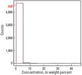
Statistics - A Horizon
| Number of samples | 4,810 |
| LLD | 0.0 wt. % |
| Number below LLD | 10 |
| Minimum | 0.0 wt. % |
| 5 percentile | 0.30 wt. % |
| 25 percentile | 0.84 wt. % |
| 50 percentile | 1.55 wt. % |
| 75 percentile | 2.80 wt. % |
| 95 percentile | 8.76 wt. % |
| Maximum | 60.1 wt. % |
| MAD | 1.26 wt. % |
| Robust CV | 81.3 % |
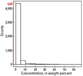
Histogram
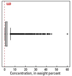
Boxplot
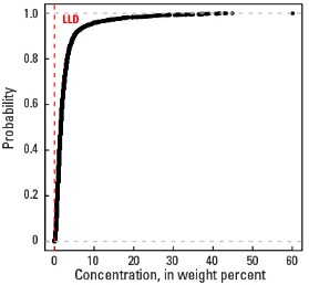
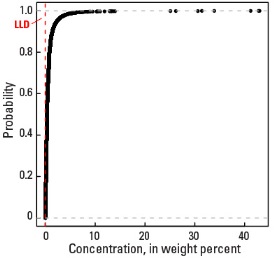
Empirical cumulative distribution function
Statistics - C Horizon
| Number of samples | 4,777 |
| LLD | 0.0 wt. % |
| Number below LLD | 114 |
| Minimum | 0.0 wt. % |
| 5 percentile | 0.05 wt. % |
| 25 percentile | 0.18 wt. % |
| 50 percentile | 0.38 wt. % |
| 75 percentile | 0.70 wt. % |
| 95 percentile | 2.35 wt. % |
| Maximum | 43.0 wt. % |
| MAD | 0.356 wt. % |
| Robust CV | 93.6 % |
Histogram
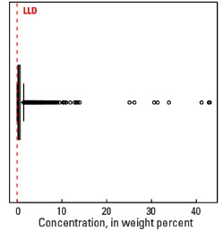
Boxplot