


The purpose of these interpretive discussions is to provide a perspective on regional- and national-scale variations in element and mineral distributions in soils and their likely causes. The significant spatial variations shown by most elements and minerals can commonly be attributed to geologic sources in underlying parent materials, but other spatial variations seem clearly related to additional factors such as climate, the age of soils, transported source material, and anthropogenic influences. We attempt to distinguish the influence of these various factors on a regional and national scale. Numerous more local features might similarly be related to these same factors, but these features also have some probability of being an artifact of a random sampling of variable compositions, so that there is some probability of samples with similar compositions occurring in clusters of two or more adjacent sites by chance. Distinguishing such random occurrences from true variability is beyond the scope of the data from which these maps are constructed. Some caution, therefore, is advisable in interpreting the significance of these more local features unless some unique sources or processes can clearly be related to them.
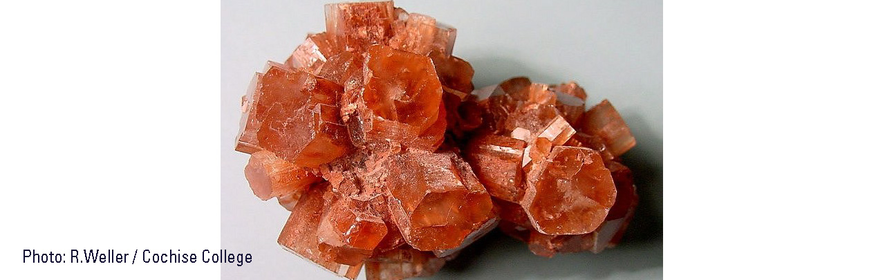
Aragonite is a calcium (Ca) carbonate (CO3) mineral chemically identical to calcite, but with a different crystal structure. Aragonite is much less common than calcite and forms through biological processes, such as deposition in mollusk shells, and by direct chemical precipitation in marine and freshwater settings. Aragonite can alter to calcite with time.
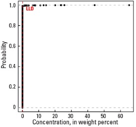
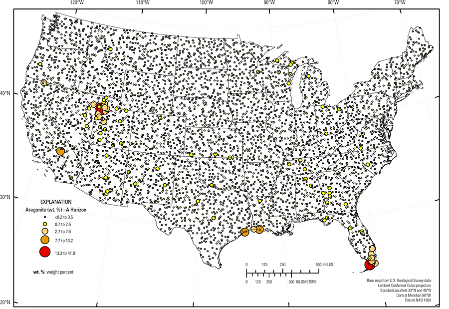
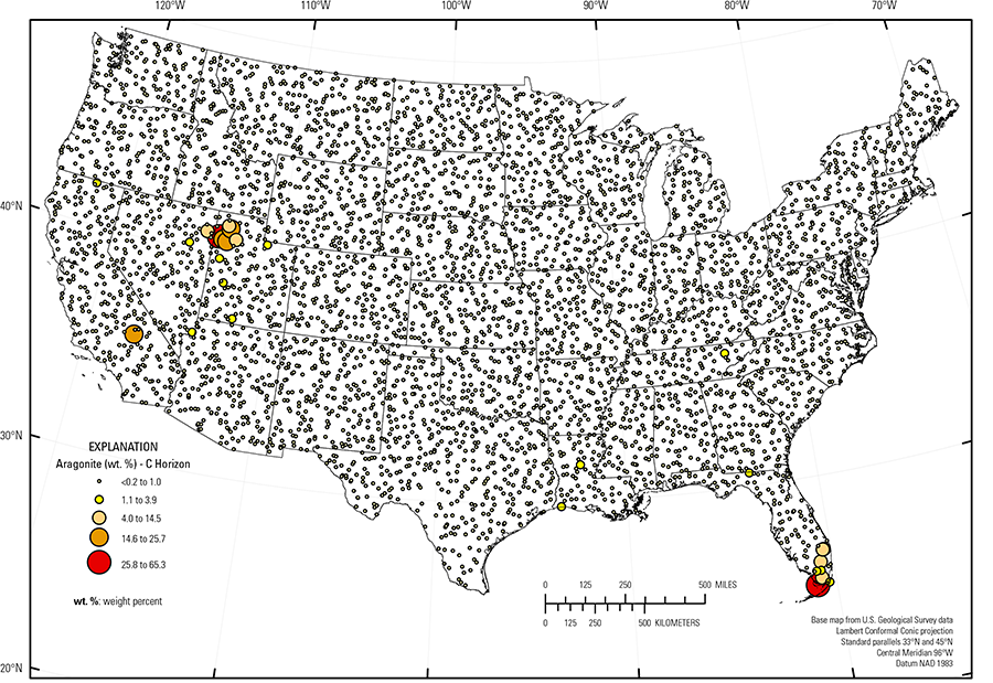
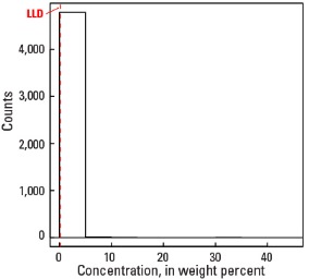
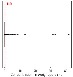
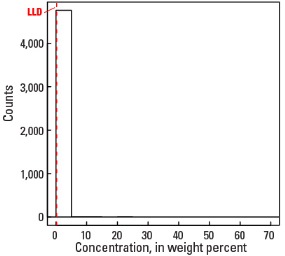
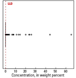
In our data, less than 1 percent of all samples of the soil C horizon and less than 3 percent of all samples of the soil A horizon contain aragonite (see the summary statistics [open in new window]). Because so few samples had aragonite concentrations above the detection limit (0.2 weight percent (wt. %)), the spatial distribution of aragonite is shown as a proportional symbol map rather than an interpolated and smoothed color surface map.
Samples with aragonite in the soil C horizon are concentrated in northwestern Utah and in southern Florida. Soils containing aragonite in Utah formed on playa muds and salt flats in the Great Salt Lake Area (USDA, 2006), often with the mineral gypsum (CaSO4•2H2O). The Great Salt Lake is all that remains of glacial Lake Bonneville, which covered this area during the last ice age. Soils in the south Florida Everglades (USDA, 2006) with relatively high aragonite concentrations developed in freshwater biogenic marl formed on limestone bedrock. These soils also have high calcite concentrations. Slightly less than 3 percent of all sample sites have aragonite in the soil A horizon; thus, while still uncommon, aragonite is more typically present in surface soil compared to deeper soil. Sites with aragonite in the soil C horizon typically also have aragonite in the soil A horizon.
Three sites along the Gulf Coast Marsh (Fenneman and Johnson, 1946) have between 7.1 and 10.3 wt. % aragonite in the soil A horizon, with low concentrations in the soil C horizon. Two of these sites in Louisiana are within the Mississippi River Chenier Plain (Penland and Suter, 1989). Cheniers are sandy or shelly beach ridges separated by mud–flat deposits created by deltaic processes of the Mississippi River as river sediments are deposited along the coast by shoreline currents. The relatively high aragonite concentrations at these two sites likely reflect shelly materials in soils.
Statistics - 0 TO 5 CM
Statistics - A Horizon
| Number of samples | 4,802 |
| LLD | 0.2 wt. % |
| Number below LLD | 4,669 |
| Minimum | <0.2 wt. % |
| 5 percentile | <0.2 wt. % |
| 25 percentile | <0.2 wt. % |
| 50 percentile | <0.2 wt. % |
| 75 percentile | <0.2 wt. % |
| 95 percentile | <0.2 wt. % |
| Maximum | 41.9 wt. % |
| MAD | |
| Robust CV |
Histogram
Boxplot

Empirical cumulative distribution function
Statistics - C Horizon
| Number of samples | 4,773 |
| LLD | 0.2 wt. % |
| Number below LLD | 4,773 |
| Minimum | <0.2 wt. % |
| 5 percentile | <0.2 wt. % |
| 25 percentile | <0.2 wt. % |
| 50 percentile | <0.2 wt. % |
| 75 percentile | <0.2 wt. % |
| 95 percentile | <0.2 wt. % |
| Maximum | 65.3 wt. % |
| MAD | |
| Robust CV |
Histogram
Boxplot