


The purpose of these interpretive discussions is to provide a perspective on regional- and national-scale variations in element and mineral distributions in soils and their likely causes. The significant spatial variations shown by most elements and minerals can commonly be attributed to geologic sources in underlying parent materials, but other spatial variations seem clearly related to additional factors such as climate, the age of soils, transported source material, and anthropogenic influences. We attempt to distinguish the influence of these various factors on a regional and national scale. Numerous more local features might similarly be related to these same factors, but these features also have some probability of being an artifact of a random sampling of variable compositions, so that there is some probability of samples with similar compositions occurring in clusters of two or more adjacent sites by chance. Distinguishing such random occurrences from true variability is beyond the scope of the data from which these maps are constructed. Some caution, therefore, is advisable in interpreting the significance of these more local features unless some unique sources or processes can clearly be related to them.
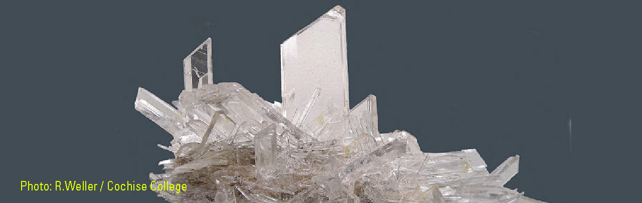
Gypsum is a hydrated calcium (Ca) sulfate mineral (CaSO4•2H2O) that occurs in sedimentary beds of limestone, shale, marl, and clay, as well as in evaporite deposits. Gypsum in soils can be primary, derived from weathered residuum of gypsum–bearing bedrock or developed on gypsum–bearing alluvial or eolian deposits. Gypsum can also form through in situ oxidation of sulfide minerals in parent materials. Development of secondary or pedogenic gypsum is complex. Pedogenic gypsum is common in regions where calcium (Ca) (Ca2+) and sulfate (SO42-) ions are available, but the depth at which it precipitates under arid to semiarid climate conditions is dependent on rainfall quantity, soil age, and soil permeability.
The distribution of mineral resource deposits with gypsum as a commodity (major or minor) in the United States, extracted from the U.S. Geological Survey (USGS) Mineral Resource Data System (MRDS) website, can be seen by hovering the mouse here. Statistics and information on the worldwide supply of, demand for, and flow of gypsum are available through the U.S. Geological Survey (USGS) National Minerals Information Center (NMIC) website.
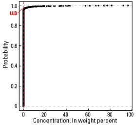
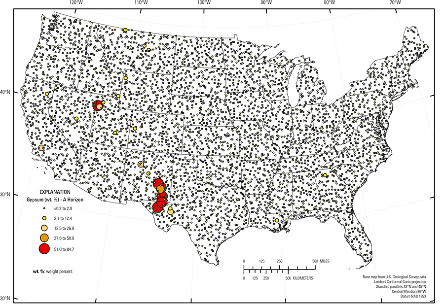
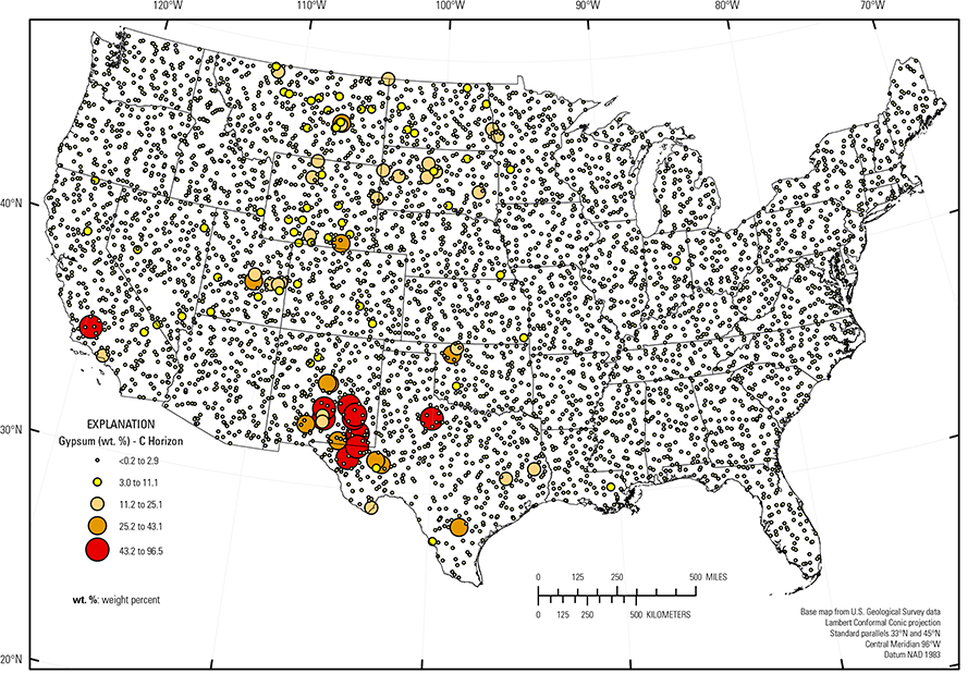
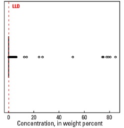
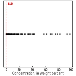
In our data, gypsum detections are extremely rare. Gypsum is reported in only 43 of the 4,802 samples in the soil A horizon and only 209 of the 4,773 samples in the soil C horizon (see the summary statistics [open in new window]). Because so few samples had gypsum concentrations above the detection limit of 0.2 weight percent (wt. %), the spatial distribution of gypsum is shown as proportional symbol maps rather than an interpolated and smoothed color surface map.
Gypsum–bearing (and often calcareous) soils are most common in arid and semiarid areas of the West that are typically water–limited, and with soils developed on (1) weathered sandstone, shale, limestone, or evaporite deposits, (2) deposits within restricted basins, or (3) on alluvial or eolian deposits derived from weathered sedimentary rocks. Examples include the Southern Desertic Basins, Plains, and Mountains, Warm Central Desertic Basins and Plateaus, Cool Central Desertic Basins and Plateaus, and Northern Intermountain Desertic Basins (USDA, 2006). Pedogenic gypsum in soils within these areas (often accompanied by calcite) precipitates at concentrations controlled by available soil moisture and soil age. In western South Dakota, western North Dakota, and eastern Montana, gypsum may have formed by alteration of pyrite in the soil C horizon where soils developed on shale or alluvium derived from shale. Other shale–influenced soil parent materials also contain thin evaporite beds; for example, gypsum–bearing soils in western Oklahoma. Soil from the C horizon at a site in southern California (with 77.4 wt. % gypsum) developed on loosely consolidated sediments that include sandstone, limestone, and evaporite deposits. In eastern Texas, soils with gypsum in the soil C horizon developed on shale, mudstone, or marl.
The distribution of gypsum through the soil profile can be highly variable because of fluctuating accumulation and dissolution of pedogenic gypsum under changing climate conditions. A few sites in the northern Great Salt Lake Area (USDA, 2006), an area underlain by alluvial fans and playa lakebed sediments, have gypsum only in the soil A horizon.
Statistics - 0 TO 5 CM
Statistics - A Horizon
| Number of samples | 4,802 |
| LLD | 0.2 wt. % |
| Number below LLD | 4,759 |
| Minimum | <0.2 wt. % |
| 5 percentile | <0.2 wt. % |
| 25 percentile | <0.2 wt. % |
| 50 percentile | <0.2 wt. % |
| 75 percentile | <0.2 wt. % |
| 95 percentile | <0.2 wt. % |
| Maximum | 84.7 wt. % |
| MAD | |
| Robust CV |
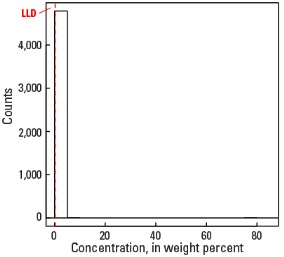
Histogram
Boxplot
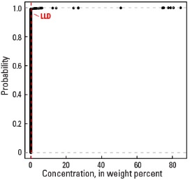
Empirical cumulative distribution function
Statistics - C Horizon
| Number of samples | 4,773 |
| LLD | 0.2 wt. % |
| Number below LLD | 4,564 |
| Minimum | <0.2 wt. % |
| 5 percentile | <0.2 wt. % |
| 25 percentile | <0.2 wt. % |
| 50 percentile | <0.2 wt. % |
| 75 percentile | <0.2 wt. % |
| 95 percentile | <0.2 wt. % |
| Maximum | 96.5 wt.% |
| MAD | |
| Robust CV |
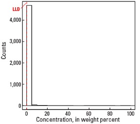
Histogram
Boxplot