Chemical analyses of ground-water samples were evaluated as part of an investigation of lower Tertiary aquifers in the eastern Powder River Basin where coalbed methane is being developed. Ground-water samples were collected from two springs discharging from clinker, eight monitoring wells completed in the Wasatch aquifer, and 13 monitoring or coalbed methane production wells completed in coalbed aquifers. The ground-water samples were analyzed for major ions and environmental isotopes (tritium and stable isotopes of hydrogen and oxygen) to characterize the composition of waters in these aquifers, to relate these characteristics to geochemical processes, and to evaluate recharge and ground-water flow within and between these aquifers. This investigation was conducted in cooperation with the Wyoming State Engineer's Office and the Bureau of Land Management.
Water quality in the different aquifers was characterized by major-ion composition. Samples collected from the two springs were classified as calcium-sulfate-type and calcium-bicarbonate-type waters. All ground-water samples from the coalbed aquifers were sodium-bicarbonate-type waters as were five of eight samples collected from the overlying Wasatch aquifer.
Potential areal patterns in ionic composition were examined. Ground-water samples collected during this and another investigation suggest that dissolved-solids concentrations in the coalbed aquifers may be lower south of the Belle Fourche River (generally less than 600 milligrams per liter). As ground water in coalbed aquifers flows to the north and northwest away from an inferred source of recharge (clinker in the study area), dissolved-solids concentrations appear to increase.
Variation in ionic composition in the vertical dimension was examined qualitatively and statistically within and between aquifers. A relationship between ionic composition and well depth was noted and corroborates similar observations by earlier investigators in the Powder River Basin in both Wyoming and Montana. This relationship results in two different water-quality zones with different characteristics - a shallow zone, comprising the upper part of the Wasatch aquifer, characterized by mixed cation composition and either sulfate or bicarbonate as the dominant anion; and a deeper zone, comprising the lower (deeper) part of the Wasatch aquifer and the underlying coalbed aquifers, characterized by sodium-bicarbonate-type waters. The zonation appears to be related to geochemical processes described by earlier investigators such as dissolution and precipitation of minerals, ion exchange, sulfate reduction, and mixing of waters. Qualitative and statistically significant differences were observed in sulfate concentrations between the coalbed aquifers and the overlying Wasatch aquifer. Ionic composition suggests that bacterially mediated redox processes such as sulfate reduction were probably the dominant geochemical processes in the anaerobic coalbed aquifers.
Tritium was used to qualitatively estimate the time of ground-water recharge. Tritium concentrations in both springs suggests that both were recharged after 1952 and contain modern water. Tritium was not detected at concentrations suggestive of modern water in any ground-water samples collected from the coalbed aquifers or in six of eight ground-water samples collected from the overlying Wasatch aquifer. Tritium concentrations in the remaining two wells from the Wasatch aquifer suggest a mixture between submodern (recharged before 1952) and modern water, although the low concentrations suggest that ground water in these two wells have very little modern water. The relative absence of modern water in all aquifers in the study area suggests that recharge processes to these aquifers are probably very slow.
Paired d2H (deuterium/hydrogen isotopic ratio) and d18O (oxygen-18/oxygen-16 isotopic ratio) values for samples collected from the springs and all aquifers are close to the Global Meteoric Water Line, a meteoric water line for North American continental precipitation, and an estimated local meteoric water line, suggesting the water in the aquifers is of meteoric origin. The d2H and d18O values suggest that the waters were recharged in a colder climate or temperature, mid-latitudes, and mid-continent. In general, the samples do not form separate groups based on aquifer origin; this suggests either intermixing of the waters in the aquifers or that the different aquifers are subject to similar recharge and/or evolutional paths for the water. However, examination of the differences in the values of d2H and d18O, in combination with major-ion chemistry at three monitoring-well clusters, suggest that changes in the values with depth may represent different timing or sources of recharge to the different aquifers.
The areal distribution of d2H was examined and an apparent break in the d2H along a northwest to southeast trend was observed. In the coalbed aquifers, all but one ground-water sample (collected from the Big George coal bed), show a pattern where the d2H values become more negative towards the center of the Powder River Basin and values greater (less negative) than an arbitrary reference value of -140 ‰ (per mil or parts per thousand) were observed near the outcrop area of the Wyodak-Anderson coal zone. In the overlying Wasatch aquifer, the d2H values became less negative towards the center of the basin. The values more negative than -140 ‰ are near the outcrop area and the values that are less negative than -140 ‰ are closer to the basin center. It is unclear if this pattern is a result of sample size, different recharge mechanisms, geochemical processes, or if the processes producing these differences are independent or unrecognized.
Results of water-quality sampling were compared with selected regulatory and non-regulatory standards as well as commonly-used guidelines for proposed water uses. Dissolved solids was the measure that most frequently exceeded U.S. Environmental Protection Agency public water-supply standards and State of Wyoming domestic-use standards in ground-water samples collected from the Wasatch aquifer and coalbed aquifers. The State of Wyoming agricultural standards (irrigation) for sulfate and dissolved solids were exceeded in some samples collected from the Wasatch aquifer and coalbed aquifers. The State of Wyoming livestock standard for pH was exceeded in some samples collected from the Wasatch aquifer. Water from the Wasatch aquifer ranged from soft to very hard, and water from the coalbed aquifers ranged from moderately hard to very hard. Samples collected from wells completed in both the Wasatch aquifer and coalbed aquifers plotted in a wide range of both sodium- and salinity-hazard classes, but most samples clustered in or near the combined medium-sodium-hazard—high-salinity-hazard classes.
| The Powder River Basin (fig. 1) in northeastern Wyoming is an important source of energy resources for the entire United States. Oil, conventional natural gas, uranium, coal, and most recently, coalbed methane (i.e., natural gas), are all developed in the basin. Since 1997, the development of coalbed methane has rapidly increased as demand for natural gas has increased in the United States. Coalbed methane is produced by pumping water from wells installed in coal beds that contain methane. The removal and discharge of this water has renewed interest in hydrological and geochemical processes that control the water quality and volumes of produced water in the coalbed aquifers. Consequently, the U.S. Geological Survey (USGS), in cooperation with the Wyoming State Engineer's Office (WSEO) and the Bureau of Land Management (BLM), conducted an investigation to enhance the understanding of the characteristics of the aquifers associated with the development of this natural resource in the Powder River Basin. This report documents the results of the investigation. | 
Figure 1. Location of the study area in the Powder River Basin, Wyoming. (Click on image for a larger version, 180 kb) |
The purpose of this investigation was to increase understanding of the aquifers in the Wasatch and Fort Union Formations of lower Tertiary age in the eastern Powder River Basin in northeastern Wyoming. The scope of the investigation included the collection of ground-water samples from springs and wells and subsequent analysis of those samples for major ions, tritium, and oxygen and hydrogen isotopes to meet the following objectives:
In addition, a bibliography was compiled as part of this investigation. While all of these references may not be directly cited in this report, they are listed in the Selected References section of this report to assist readers searching for additional information about coalbed methane and the geology and hydrogeology of lower Tertiary formations in the Powder River Basin.
|
Wells and springs are identified by location using a 15 digit USGS well-identification number consisting of latitude, longitude, and a sequence number (fig. 2). For example, site 433652105075501 is the first site inventoried at a location having a latitude of 43 degrees, 36 minutes, and 52 seconds, and a longitude of 105 degrees, 7 minutes, and 55 seconds. The last two digits in the well-identification number (01) are a sequence number indicating the order of inventory. A local well number also is assigned to wells and springs using the Federal township-range system of land subdivision. An example of a local number established for a well used in this report is 45-072-03dbc01 (fig. 2). The first number (45) denotes the township (T), the second number (072) denotes the range (R), and the third number (03) denotes the section. The first letter following the section number denotes the quarter section (160-acre tract); the second letter, the quarter-quarter section (40-acre tract); and the third letter, if shown, the quarter-quarter-quarter section (10-acre tract). These subsections are designated a, b, c, and d in a counter-clockwise direction, beginning in the northeast quadrant. The last two digits in the local number are a sequence number indicating the order of inventory. For example, well 45-072-03dbc01 is the first well inventoried in the southwest quarter of the northwest quarter of the southeast quarter of section 3, T. 45 N., R. 072 W. |
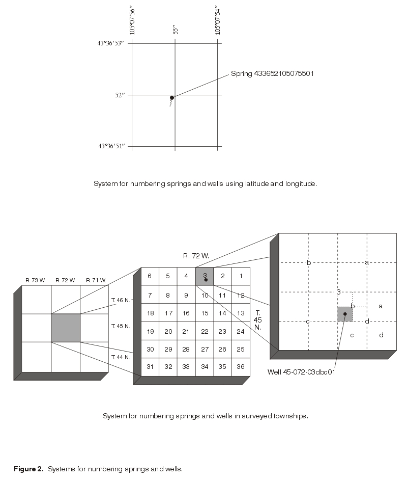
Figure 2. Systems for numbering springs and wells. (Click on image for a larger version, 28 kb) |
Abbreviated site numbers are often used to describe well locations in place of USGS well-identification numbers, local well numbers, or local well names for all wells discussed in this report. For example, W1 indicates well W1 is completed in the Wasatch aquifer, and C1 indicates well C1 is completed in a coalbed aquifer. Site numbers, USGS well-identification numbers, and local well numbers are listed in the tables. Only site numbers are used in illustrations.
Ground-water samples for water-quality analyses were collected during June 1999 from 27 locations in or near areas of coalbed methane development. Samples were collected from two springs discharging from clinker, eight BLM or WSEO monitoring wells completed in the Wasatch aquifer, seven BLM or WSEO monitoring wells completed in the coalbed aquifers, and ten coalbed methane production wells completed in the coalbed aquifers.
Different sampling devices and techniques were used to collect the various ground-water samples. Samples were collected from the springs by submerging sampling containers as close as possible to the point of discharge. In addition, samples were not collected from the springs if it had rained several days prior to arrival at the site to ensure that the samples represented discharge from the springs and were not influenced by surface-water runoff. Submersible pumps were used to collect samples from all but one monitoring well; the remaining well had sufficient gas and artesian pressure (hydraulic head) to sample without a pump. Coalbed methane production wells were sampled using submersible pumps already present in the wells. Attempts were made to remove (purge) a minimum of three casing volumes of water from each monitoring well and to allow onsite measurements (pH, specific conductance, and temperature) to stabilize prior to sample collection to ensure that the sample collected represented the ground water rather than water stored in the well casing. During purging at several wells, gas-lock of the pump or water-level drawdown prevented removal of three casing volumes; these wells were sampled after the pump could be restarted or after sufficient time was allowed for water-level recovery (because of drawdown). Purging, or removal of three casing volumes of water, was not conducted at coalbed methane production wells because the wells are actively pumping water to produce methane; however, the wells were allowed to discharge water for some period of time prior to sample collection and onsite measurements of field parameters were monitored for stability.
Quality-assurance procedures involved calibration of all field meters, collection of quality-control samples (replicates), and use of standardized USGS sampling, processing, and analytical techniques. Field meters were calibrated prior to sampling at each well. Quality-control samples consisted of two replicate (duplicate) ground-water samples. Water-quality samples were collected, preserved, and shipped according to standardized USGS techniques described in Book 9 of the USGS National Field Manual for the Collection of Water-Quality Data (Wilde and others; 1998; Wilde and Radtke, 1998; Wilde and others, 1999). Water-quality samples were analyzed at USGS laboratories using standardized USGS laboratory analytical methods and laboratory quality-assurance procedures as documented in Fishman and Friedman (1989). Ground-water samples were analyzed by the inductively coupled plasma method with atomic emission spectrometry for major ions (Fishman and Friedman, 1989; Fishman, 1993), tritium by electrolytic enrichment with gas counting (Ostlund and Dorsey, 1977), d2H (deuterium/hydrogen isotopic ratio) by hydrogen equilibrium (Coplen and others, 1991) and d18O (oxygen-18/oxygen-16 isotopic ratio) by carbon dioxide equilibrium (Epstein and Mayeda, 1953). For this report, dissolved refers to constituents in water samples that passed through a 0.45-micrometer disposable cartridge filter during sample collection.
Each well was located using a military-grade Global Positioning System (GPS) receiver to obtain the latitude and longitude. The well was then plotted on the appropriate USGS Quadrangle maps (1:24,000 scale) to obtain land-surface elevations.
Water levels in monitoring wells were measured prior to sampling. Each monitoring well was equipped with a dedicated water-level recorder that was removed prior to water-quality sampling. Water levels measured by the recorders were noted immediately prior to removal. Water levels could not be measured in coalbed methane production wells, so water-level measurements from these wells were obtained from WSEO well permits. Well-completion information (i.e., well depths, casing material, screened or opened intervals) also was obtained from WSEO well permits.
Water-quality data commonly are not normally distributed and commonly contain censored data values (unquantified data reported as being less than some value, such as a minimum reporting level (MRL)). In addition, nonnormality is difficult to detect with small sample sizes. Nonparametric statistics do not rely on an assumption that data are normally distributed, are resistant to the effects of outliers, and are more appropriate when sample sizes are small (Helsel and Hirsch, 1992). Therefore, nonparametric statistical methods are used exclusively to describe and analyze water-quality data in this report. Individual methods are described in the sections where used.
The climate of the study area is classified as a steppe climate typical of semiarid grassland prairies (Martner, 1986). The average mean temperature in Gillette for 1961 to 1990 was 44.2 degrees Fahrenheit, but temperature and precipitation vary widely, depending upon the season (Western Regional Climate Center, 2001). Mean annual precipitation for 1961 through 1990 in Gillette was 16.61 inches (Western Regional Climate Center, 2001). Estimated mean annual evaporation greatly exceeds mean annual precipitation in the study area; mean annual evaporation estimated from Class-A pans ranges from about 65 to 70 inches per year, while mean annual evaporation estimated from lakes ranges from about 45 to 50 inches per year (Martner, 1986, p. 177, and references therein). Estimated mean annual potential evapotranspiration also exceeds precipitation in most of the study area for 1951 through 1980 and was about 22 to 23 inches, based on the Thornthwaite method (Martner, 1986, p. 182). Wind in the study area is primarily from the west, and the average hourly wind velocity in the area is about 13 miles per hour (Lowry, Wilson, and others, 1986).
The name Powder River Basin has been used to refer to both a structural basin and a drainage basin. The structural basin and the drainage basin do not coincide and both are frequently used interchangeably to define the area. In this report, Powder River Basin refers to the structural basin. The Powder River Basin is an asymmetrical syncline formed during the Laramide orogeny (Late Cretaceous to early Tertiary age). The axis of the basin trends from southeast to northwest near the western margin of the basin (fig. 1), far from its geographic center. In Wyoming, the Powder River Basin is bounded by the Black Hills uplift in the northeast, the Hartville uplift in the southeast, the Laramie Mountains in the south, the Casper arch in the southwest, and the Bighorn Mountains in the west (fig. 1). The basin continues northward into Montana (not shown in fig. 1), where another structural feature, the Cedar Ridge anticline, separates it from the Williston Basin. The entire basin covers an area of more than 22,000 square miles (Flores and others, 1999). The Powder River drainage basin refers to the area in Wyoming and Montana drained by the perennial Powder River and its tributaries. The Powder River Basin includes not only the Powder River and associated tributaries, but also the upstream parts of the Belle Fourche River, Cheyenne River, and Tongue River drainage basins (fig. 1). The study area is in the eastern part of the Powder River Basin, within the unglaciated part of the Missouri Plateau of the Northern Great Plains and the Missouri River drainage basin. In the study area, the perennial Powder River and Little Powder River flow northward and the perennial Belle Fourche River flows northeastward (fig. 1). Tributaries to these rivers are primarily ephemeral, with streamflow resulting from precipitation (Lowry, Wilson, and others, 1986). Grass-covered plains, rolling hills, and tablelands dominate the landscape. Rivers and streams have eroded deeply in the area and have wide, flat streambeds and broad floodplains. Isolated flat-topped buttes, mesas, and ridges commonly are present several hundred feet above valley floors.
| Within the study area, the geologic units of interest are lower Tertiary in age. In ascending stratigraphic order, these geologic units are the Fort Union Formation of Paleocene age and the Wasatch Formation of Eocene age (fig. 3). Sediments comprising both formations have been interpreted to be continental in origin. The Fort Union Formation in the Powder River Basin was deposited by northeastward-flowing fluvial systems consisting of braided, meandering, and anastomosed streams in the basin center; these fluvial systems were fed by alluvial fans at the basin margin associated with surrounding ancestral uplifts (Flores and Ethridge, 1985; Flores, 1986). The Wasatch Formation overlies the Fort Union Formation and is exposed at the surface throughout much of the Powder River Basin in Wyoming, including the study area (fig. 4). The Fort Union Formation is exposed primarily along the margins of the basin in Wyoming, including the eastern edge of the study area (fig. 4). The Wasatch Formation was deposited in conditions similar to those of the Fort Union Formation, primarily fluvial, lacustrine, and swampy environments (Seeland, 1992; Ellis and others, 1999a). | 
Figure 3. Generalized stratigraphic column of the Wasatch and Fort Union Formations in the central Powder River Basin, Wyoming (modified from Flores and Bader, 1999). (Click on image for a larger version, 80 kb) |
| The Fort Union Formation in the Powder River Basin ranges in thickness from 2,300 to 6,000 ft (feet) (Curry, 1971) and is subdivided into three members - the Tullock, Lebo, and Tongue River Members (fig. 3). Along the eastern margin of the Powder River Basin, including the study area, the Fort Union Formation is nearly flat and dips to the west about 2 to 3 degrees (Glass, 1997). Near the western margin, the Fort Union Formation dips to the east from 10 to 25 degrees (Glass, 1997). The Tullock Member ranges in thickness from 370 to about 1,440 ft (Brown, 1993) and consists primarily of lenticular, discontinuous, fine to medium-grained sandstone beds interbedded with fine-grained sediments such as siltstone, claystone, mudstone, carbonaceous shale, rare limestone, and thin coal beds (Curry, 1971). The Lebo Member ranges in thickness from about 499 to about 1,700 ft (Law, 1975; Lewis and Hotchkiss, 1981) and consists primarily of shale or mudstone interbedded with lesser amounts of sandstone, siltstone, and sparse, very thin coal beds. Like the Tullock Member, the Tongue River Member (as much as 1,860 ft thick (Curry, 1971)) also consists primarily of lenticular, discontinuous, fine to medium-grained sandstone beds interbedded with fine-grained sediments such as siltstone, claystone, mudstone, carbonaceous shale, and limestone; however, in contrast, coal beds are more common, thicker, and laterally continuous in the Tongue River Member. | 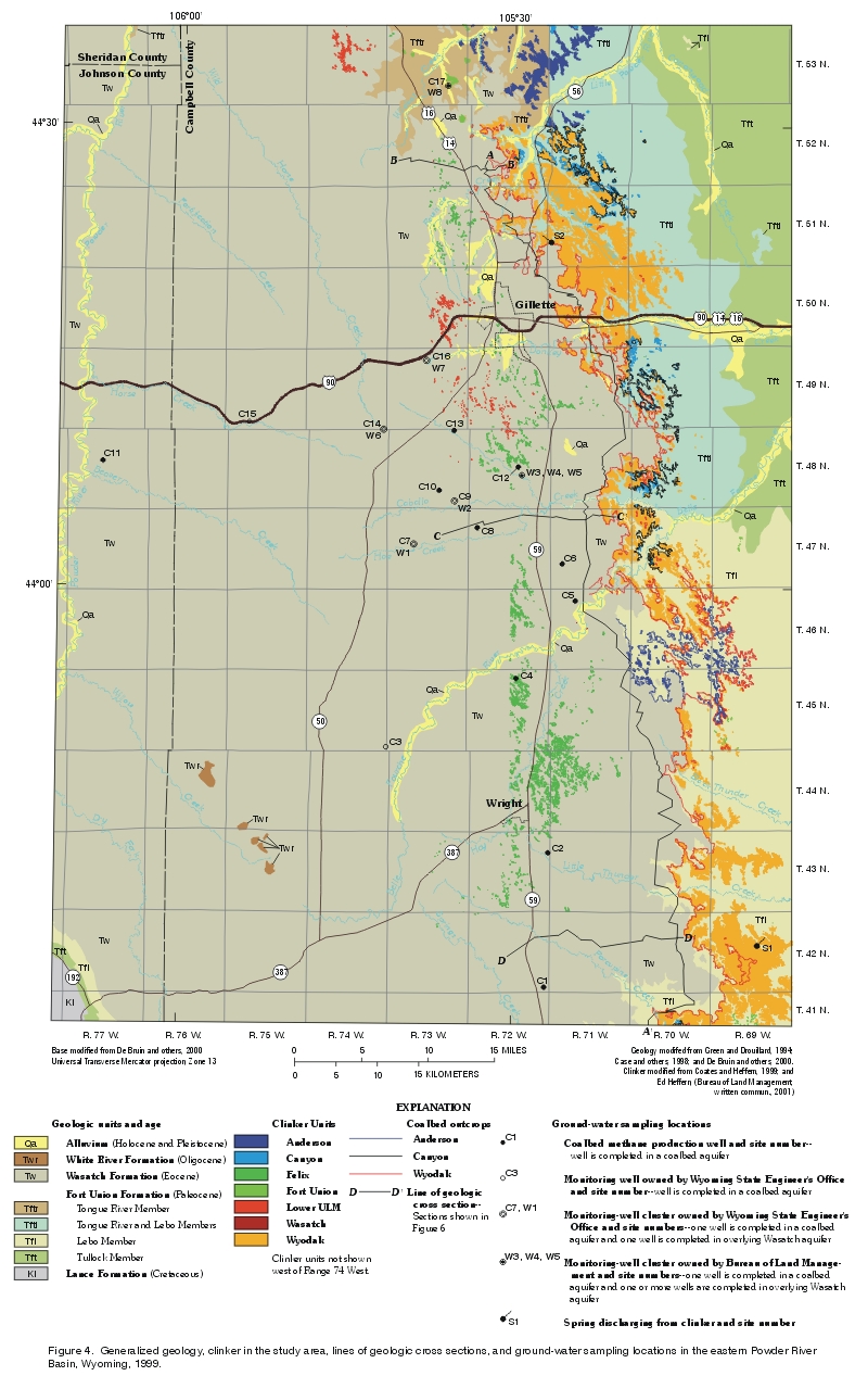
Figure 4. Generalized geology, clinker in the study area, lines of geologic cross sections, and ground-water sampling locations in the eastern Powder River Basin, Wyoming, 1999. (Click on image for a larger version, 1.15 mb) |
| While there are many thick coal beds in the Tongue River Member, the thickest and most laterally continuous coal beds are associated with a coal zone present basinwide in Wyoming and Montana known as the Wyodak-Anderson coal zone (Averitt, 1975; Glass, 1980). The Wyodak-Anderson coal zone is composed of different coal beds (fig. 3) that split, merge, re-split, or pinch out (fig. 5). Goolsby and Finley (2000) recently suggested that the coal beds of the Wyodak-Anderson coal zone and some coal beds below the zone (fig. 3) may represent a single lithologic unit that was deposited in a corkscrew-type structure as the result of a depositional center that migrated over time. As many as six of these coal beds can comprise the coal zone in any given location (Ellis, 1999). Currently, 11 individual coal beds have now been identified in the coal zone (Flores and others, 1999). The coal beds of the Wyodak-Anderson coal zone "were deposited in low-lying peat swamps and raised mires, and associated detrital rocks were deposited by trunk-tributary, meandering, anastomosed, and braided streams" (Flores, 1999, p. 6, and references therein). Historically, the naming of these many beds has been extremely complicated and the correlation of the beds controversial (Flores, 1999). Despite this complexity and as a result of much work by many investigators over many years, the Wyodak-Anderson coal zone has been correlated throughout the Powder River Basin in Wyoming. Many of the beds comprising the zone have been correlated throughout the basin and are laterally continuous over large distances (Glass, 1980, 1997; Ellis and others, 1999a; Flores, 1999; Flores and others, 1999) (fig. 5). | 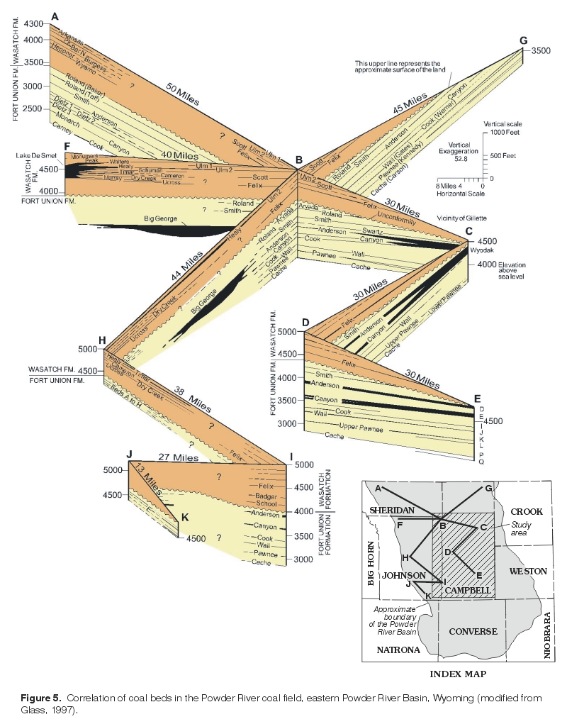
Figure 5. Correlation of coal beds in the Powder River coal field, eastern Powder River Basin, Wyoming (modified from Glass, 1997). (Click on image for a larger version, 6.92 mb) |
The Wyodak-Anderson coal zone and the individual beds comprising the zone vary widely in thickness and depend on geographic location. Although estimates vary widely, the most recent estimate suggests that the Wyodak-Anderson coal zone in the Powder River Basin in Wyoming and Montana "has a maximum net coal thickness (total thickness of all coal beds greater than 2.5 ft thick) of 284 ft" and that "the entire zone is more than 600 ft thick (measured from the top of the uppermost coal to the base of the lowermost coal) in the center part of the basin" (Ellis, 1999, p. 44). Throughout the basin, coal beds comprising the coal zone "average 25 ft in thickness, and are separated by clastic sedimentary rocks ranging from a few feet to 150 ft in thickness" (Ellis, 1999, p. 44). The coal beds of the Wyodak-Anderson coal zone outcrop or subcrop along the eastern margin of the basin (fig. 4). Consequently, this area is where most of the coal mining in the basin occurs. In the vicinity of the city of Gillette, several of the coal beds of the Wyodak-Anderson coal zone merge to form a single thick coal bed known as the Wyodak coal bed (location C, fig. 5). The Wyodak coal bed splits into several seams south, east, and north of Gillette (fig. 5). The maximum thickness of a single merged coal bed within the Wyodak-Anderson coal zone in the Gillette coal field is 145 ft (Ellis and others, 1999a). The complexity of the Wyodak-Anderson coal zone and associated coal beds is illustrated in several cross sections within the study area (fig. 6). The reader is referred to Flores (1999) and Flores and Bader (1999) for a detailed historical review, discussion, and interpretation of the Wyodak-Anderson coal zone in the Powder River Basin in Wyoming and Montana.
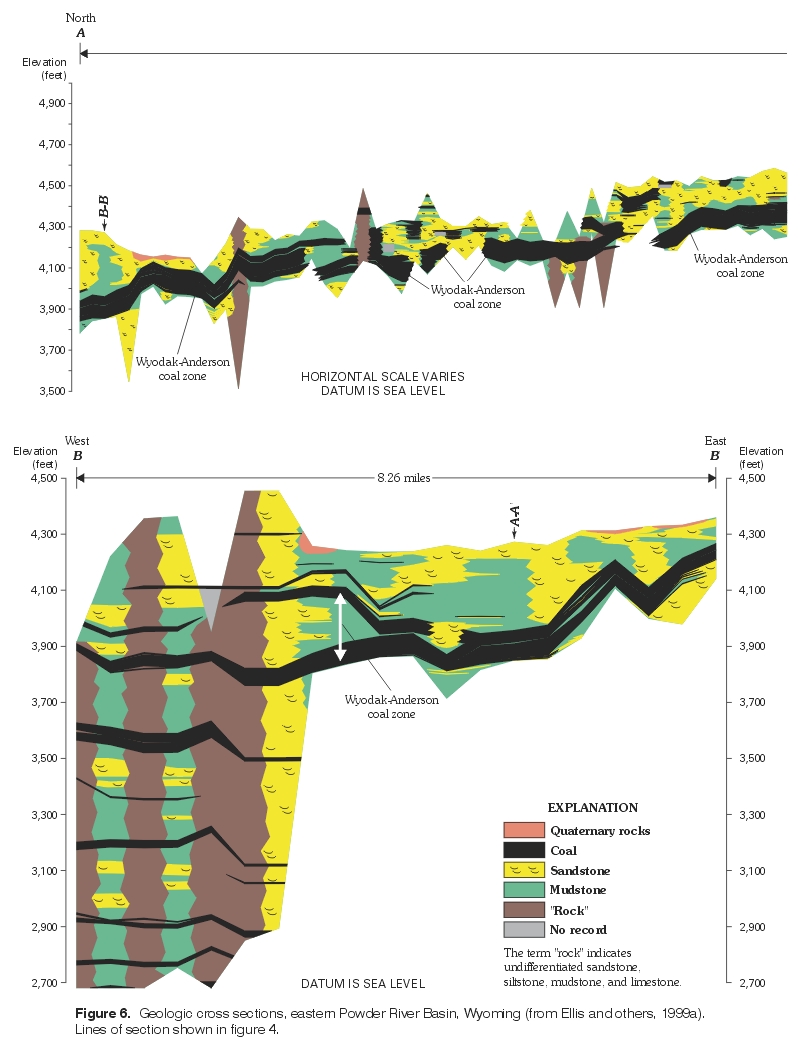
Figure 6. Geologic cross sections, eastern Powder River Basin, Wyoming (from Ellis and others, 1999a). Lines of section shown in figure 4. (Click on image for a larger version, 80 kb) |
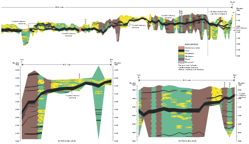
Figure 6. Continued. (Click on image for a larger version, 140 kb) |
Along the eastern part of the study area where the Wyodak-Anderson coal zone outcrops or subcrops (fig. 4), the coal beds have burned and baked the sediments around the beds to form rock known as clinker (also frequently referred to as scoria). Clinker is a distinct orange to red color throughout the basin and in the study area. The clinker covers about a 250-square mile area along the eastern boundary of the Gillette coal field east of Gillette and Wright (Heffern and Coates, 1997). The clinker is resistant to erosion and caps many of the topographically high locations in the area (Heffern and Coates, 1997).
The Wasatch Formation, like the Tongue River Member of the Fort Union Formation, consists primarily of fine- to coarse-grained lenticular, discontinuous sandstone beds interbedded with fine-grained sediments such as shale, siltstone, claystone, and mudstone. Consequently, the Wasatch Formation is difficult to distinguish from the underlying Fort Union Formation, especially in the subsurface, because of similarity both in lithology and in depositional history (Ellis and others, 1999a). The contact between these two formations and its relationship to the Paleocene-Eocene boundary remains controversial (Flores, 1999), but the contact commonly is placed above a coal bed, the Roland coal (Olive, 1957) (figs. 3 and 5). Palynostratigraphic differences (Tschudy, 1976; Nichols, 1994, 1998; Nichols and Brown, 1992) and mineralogical differences (Denson and others, 1989a, 1989b) typically are used to identify the two formations and locate the contact in the subsurface. The reader is referred to Flores (1999) and Flores and Bader (1999) for an overview and discussion of the contact between the Wasatch and Fort Union Formations. In the study area, many of the coal mines and coalbed methane developers consider the top of the Wyodak-Anderson coal zone as the contact, even though some of the Fort Union Formation may be present above the coal zone and below the overlying Wasatch Formation; this convention will be followed in this report. Dip of the Wasatch Formation is shallow, generally less than 4 degrees (Glass, 1997). The Wasatch Formation contains many coal beds, with the thickest beds in the western and central parts of the Powder River Basin outside the study area, particularly near Lake De Smet (fig. 5) (Glass, 1980, 1997). Clinker is present in the Wasatch Formation in many locations (fig. 4) and frequently forms caprocks because it is more resistant to weathering than surrounding rock (Heffern and others, 1996; Heffern and Coates, 1999).
Methane (CH4) is found in the coal beds of the study area and sometimes in lithological units, such as sandstone lenses, located immediately above or below the coal beds (Jones and De Bruin, 1990; Law and others, 1991; Rice, 1993). Coalbed methane is created by a series of processes (discussed in greater detail later in this report) that convert organic matter present in coal into methane. Coalbed methane in the Powder River Basin is composed almost entirely of methane, with a small amount of carbon dioxide (1.5 to 2 percent) (Law and others; 1991; Rice, 1993; De Bruin and others, 2000); composition is suspected to be very uniform throughout the basin (Rice, 1993). Based on the rank of the coal and the isotopic composition of the methane in the lower Tertiary coal beds of the Powder River Basin, it is believed that the coalbed methane was primarily generated from bacterial activity (biogenic) as opposed to heating (thermogenic) (Boreck and Weaver, 1984; Law and others, 1991; Rice and Flores, 1990, 1991; Rice, 1993; Gorody, 1999). Coalbed methane is believed to be stored in coal beds in four possible ways (Yee and others, 1993): (1) as free gas within small pores (micropores) and fractures (cleats); (2) as gas dissolved in water within the coal; (3) as gas adsorbed on surfaces of organic material, micropores, and cleats; and (4) as gas absorbed within the molecular structure of the coal molecules. De Bruin and others (2000) suggest the gas in the shallow coal beds of the study area is probably stored primarily as free gas and dissolved gas where good cleat development is present. The reader is referred to the recent publication by De Bruin and others (2000) for a discussion of coalbed methane in both the Powder River Basin and the State of Wyoming and recent publications by Rice (1997) and Nuccio (2000) for discussions of coalbed methane in the U.S.
|
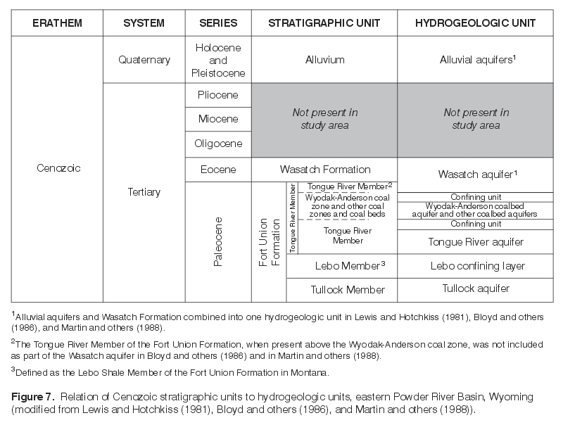
The relations of Cenozoic stratigraphic units to assigned hydrogeologic units in this study are shown in figure 7. Only the hydrogeology of the geologic units overlying and associated with the Wyodak-Anderson coal zone (Wasatch and Fort Union Formations) will be discussed. Convention in this report will be to use the geologic unit (i.e., member, formation, coal bed or coal zone) as the hydrogeologic unit or aquifer name, even though multiple aquifers may be present in any one geologic unit. The Wyodak-Anderson coal zone and its associated coal beds comprise the most continuous hydrogeologic unit or aquifer in lower Tertiary deposits in the study area (Bloyd and others, 1986; Lowry, Wilson, and others, 1986; Martin and others, 1988). Because of the complicated history of the naming and correlation of the various coal beds comprising the Wyodak-Anderson coal zone, the aquifer within the coal zone has been referred to by many names, most frequently as the Wyodak coal aquifer or the Wyodak-Anderson coal or coalbed aquifer. The convention used in this report will be to use Wyodak-Anderson coalbed aquifer (fig. 7). Martin and others (1988) suggested that the aquifer can consist of not only the coal beds within the zone, but also the interbedded sandstone beds and the clinker along the coal outcrop. Aquifers present in other coal beds below the Wyodak-Anderson coal zone in the Tongue River Member of the Fort Union Formation will be combined with the coal zone in this report and will be collectively referred to as coalbed aquifers. |
Figure 7. Relation of Cenozoic stratigraphic units to hydrogeologic units, eastern Powder River Basin, Wyoming (modified from Lewis and Hotchkiss (1981), Bloyd and others (1986), and Martin and others (1988)). (Click on image for a larger version, 20 kb) |
Water in the Wyodak-Anderson coalbed aquifer is typically unconfined near the outcrop along the eastern margin of the basin in the study area (Davis, 1976; Heffern and Coates, 1999) but becomes confined to the west, away from the outcrop and downdip (Davis, 1976; Martin and others, 1988). The aquifer is confined above by overlying low permeability shales or other fine-grained units in the Tongue River Member of the Fort Union Formation or Wasatch Formation and below by low permeability shale or other fine-grained units in the Tongue River Member (Martin and others, 1988). Artesian conditions can exist; Whitcomb and others (1966) also noted that the gas present within the coal beds or associated geologic materials (for example, sandstone lenses above or below the coal bed) can contribute significantly to hydraulic head in wells in the Powder River Basin and may cause water levels to rise higher than if only artesian pressure were present.
The amount of hydraulic connection under natural conditions between the Wyodak-Anderson coalbed aquifer and sandstone lenses comprising aquifers in the overlying Wasatch or Fort Union Formations is unclear. Many investigators have suggested that downward vertical flow or leakage from overlying geologic units to the Wyodak-Anderson coalbed aquifer is small because of low vertical hydraulic conductivity of the overlying rocks (Davis and Rechard, 1977; Feathers and others, 1981; Bloyd and others, 1986), even though a downward vertical gradient between the coalbed aquifer and the overlying Wasatch aquifer is commonly present (Ground-Water Subgroup, 1974; Davis, 1976; Bureau of Land Management, 1999). However, some leakage probably occurs downward where the hydraulic gradient allows for downward vertical ground-water flow and where sandstone lenses may directly overlie the coalbed aquifer (Bureau of Land Management, 1999).
The Wyodak-Anderson coalbed aquifer is anisotropic; ground-water flow primarily occurs through fractures (cleats) in the coal bed (Ground-Water Subgroup, 1974; Brown, 1980; Rehm and others, 1980; Martin and others, 1988). Flow direction in this aquifer may change where the coal bed splits into other beds and is interbedded with other lithological units and where differences in the distribution and density of the fractures (cleats) in the coal occur (Martin and others, 1988). Anisotropy in coal beds in the Wasatch and Fort Union Formations of the Powder River Basin in both Wyoming and Montana has been examined or discussed by Stone and Snoeberger (1977), Rehm and others (1980), Stoner (1981), Dobson (1996), and Peacock (1997). In general, these investigators suggest that anisotropy in coals from both the Wasatch and Fort Union Formations in the Powder River Basin appears to be related to cleat orientation; cleat orientation may be oriented to major structural features (e.g., basin axis, lineaments, and faults).
Hydraulic conductivity values from aquifer tests conducted in the Wyodak-Anderson coalbed aquifer were summarized in Martin and others (1988) and Peacock (1997). Martin and others examined 357 aquifer tests conducted in the Wyodak-Anderson coalbed aquifer at coal mines in the Powder River Basin in Wyoming and noted hydraulic conductivity values approxi-mated a lognormal distribution with a geometric mean of 0.8 ft per day. Peacock (1997) reported a geometric mean of about 0.5 ft per day for 166 aquifer tests conducted in the Wyodak-Anderson coalbed aquifer in the study area. Rehm and others (1980) summarized hydraulic conductivities from 193 aquifer tests conducted in Paleocene coal beds (Fort Union Formation or Group) in the Northern Great Plains (including the Powder River Basin in Wyoming and Montana). The investigators reported the frequency distribution of coalbed conductivity values approximated a lognormal distribution with a geometric mean of about 0.9 ft per day.
|
Regional flow within the Wyodak-Anderson coalbed aquifer is suspected to be to the north and northwest, based on a potentiometric-surface map prepared by Daddow (1986) (fig. 8). Regional ground-water flow in the area near Porcupine Creek (fig. 8) may be to the north (Martin and others, 1988). The relationship between regional ground-water flow in the coalbed aquifers and the Fort Union Formation in the Powder River Basin has not been examined. Recharge to the aquifer is suspected to occur primarily along the outcrop areas of clinker associated with the Wyodak-Anderson coal zone (Lowry and Cummings, 1966; Whitcomb and others, 1966; Davis, 1976; Martin and others, 1988; Heffern and Coates, 1999). In the study area, the clinker associated with the Wyodak-Anderson coalbed aquifer is located along the eastern margin, near the outcrop area (fig. 4). Recharge also may occur locally where the coal bed subcrops below the alluvium in the stream valleys (Davis, 1976; Davis and Rechard, 1977; Martin and others, 1988). Discharge is suspected to primarily occur in areas where the coal subcrops under the base of alluvium in valleys (Brown, 1980; Martin and others, 1988) or as downward leakage (Brown, 1980). |
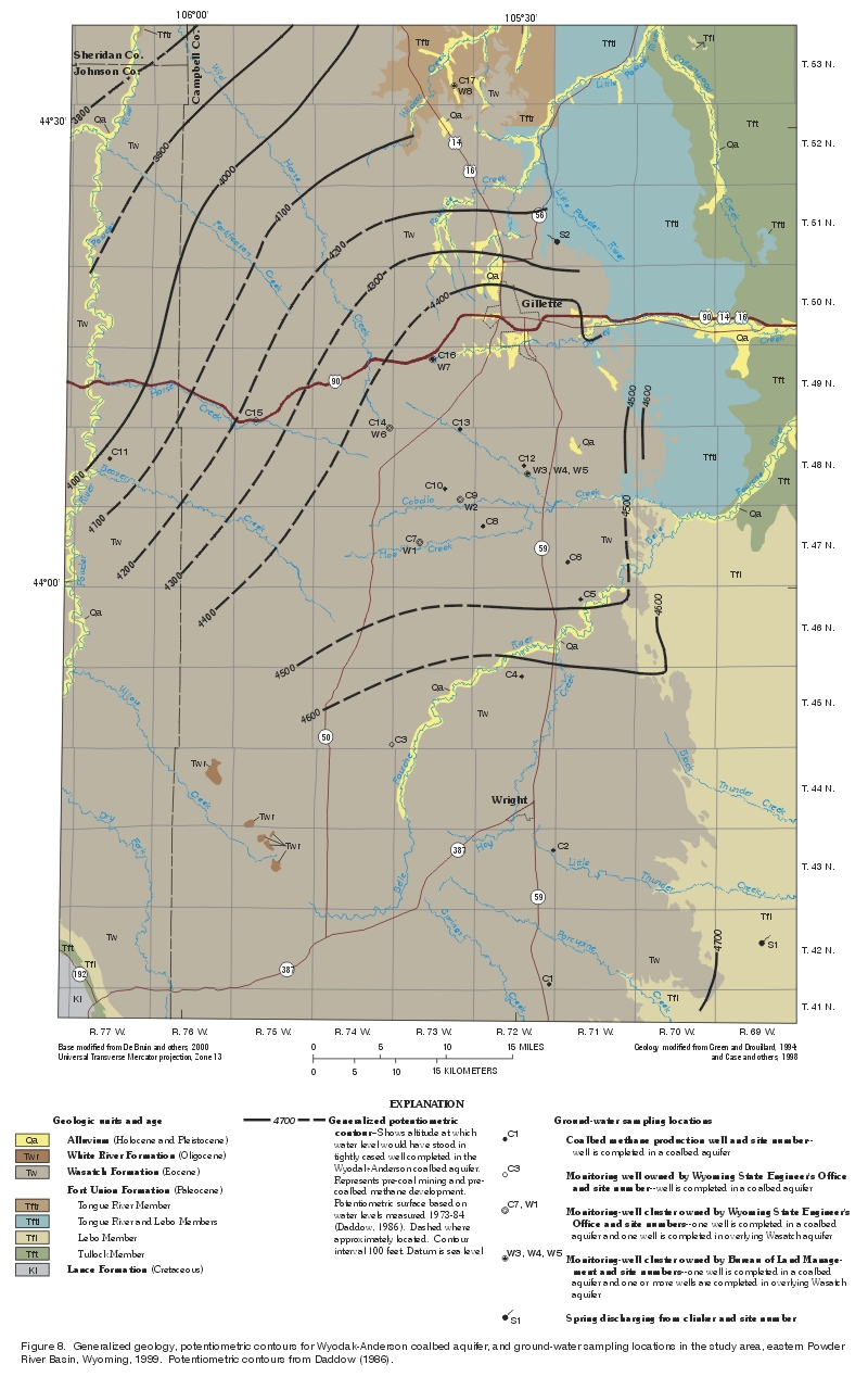
Figure 8. Generalized geology, potentiometric contours for Wyodak-Anderson coalbed aquifer, and ground-water sampling locations in the study area, eastern Powder River Basin, Wyoming, 1999. Potentiometric contours from Daddow (1986). (Click on image for a larger version, 435 kb) |
Clinker associated with and considered part of the Wyodak-Anderson coalbed aquifer by some investigators is highly permeable, may store large quantities of water, and may function locally as an unconfined or confined aquifer (Davis, 1976; Heffern and others, 1996; Heffern and Coates, 1999). Recharge of the clinker occurs vertically from precipitation, from streams that cross the clinker, and from lateral inflow from clinker or unburned coal and overburden updip (Heffern and Coates, 1999). Recharge rates to the clinker are suspected to be very high, especially compared to surrounding geologic units (Heffern and Coates, 1999). Transmissivities of the clinker are very high, and based on tests conducted at coal mines in the area, range from 10,000 to more than 1,000,000 feet squared per day (Heffern and Coates, 1999).
In a large part of the study area, the Wasatch Formation is exposed at land surface and overlies the Wyodak-Anderson coal zone. As stated previously and illustrated in figure 7, convention in this report will be to define the top of the Wyodak-Anderson coal zone and the aquifer contained within as the contact between the Fort Union Formation and the overlying Wasatch Formation and aquifer. The Wasatch aquifer consists primarily of discontinuous lenticular sandstone beds surrounded by fine-grained sedimentary rocks with low permeability such as siltstone, claystone, mudstone, carbonaceous shale, and limestone, although coal beds may be locally important if present. The discontinuous, lenticular sandstone beds are the actual geologic materials that primarily yield water to wells and comprise the aquifer (Littleton, 1950; Hagmaier, 1971; Hodson and others, 1973; Ground-Water Subgroup, 1974; Bloyd and others, 1986; Martin and others, 1988; Lowry and others, 1993).
Fine-grained sedimentary rocks in the Wasatch Formation do not yield sufficient quantities of water to be considered as an aquifer, even though they may be saturated and static water levels in wells completed in the fine-grained rocks may be the same as in adjacent beds of sandstone (Brown, 1980; Martin and others, 1988). The sandstone lenses have been considered as individual aquifers because they are surrounded by low permeability sedimentary rocks and they may be relatively hydraulically isolated from each other (Lowry and others, 1993). The yield of wells completed in the Wasatch aquifer is directly related to the number and thickness of sandstone lenses or beds penetrated by the well. Unconfined and confined conditions can exist in the Wasatch aquifer (Littleton, 1950; Whitcomb and others, 1966; Davis, 1976), although the sandstone beds comprising the aquifer may be primarily confined (Lowry and others, 1993).
Hydraulic conductivity values for aquifer tests conducted in the sandstones comprising the Wasatch aquifer were summarized in Martin and others (1988) and Peacock (1997). Martin and others (1988, p. 19) noted that the frequency distribution "of the hydraulic conductivity of the Wasatch aquifer has a lognormal distribution with a geometric mean of 0.2 ft per day." Similarly, Peacock also noted a lognormal distribution and reported a geometric mean of about 0.3 ft per day for the Wasatch aquifer. Rehm and others (1980) reported a very similar geometric mean (0.35 ft per day) for sandstones of the Fort Union Group in the Northern Great Plains. The investigators also noted that fine-grained sedimentary rocks (e.g., siltstones, claystones, and mudstones) associated with the Fort Union Group were much less permeable and reported a geometric mean of 0.007 ft per day (Rehm and others, 1980).
Recharge to the Wasatch aquifer is suspected to be primarily from areal infiltration and percolation of precipitation (King, 1974; Ground-Water Subgroup, 1974; Brown, 1980). Infiltration to the Wasatch aquifer may be enhanced by clinker throughout the area (Davis, 1976; Bloyd and others, 1986; Martin and others, 1988).
Ground-water flow in the Wasatch aquifer is suspected to be primarily local and related to topography, with discharge occurring primarily along streams adjacent to local recharge areas (Hagmaier, 1971; King, 1974; Bloyd and others, 1986; Martin and others, 1988) and possibly underflow out of the study area (Bloyd and others, 1986). Brown (1980) also noted that discharge to clinker may occur in some areas. Investigators differ on whether regional ground-water flow in the Wasatch aquifer occurs and the relationship between local ground-water flow and possible intermediate and regional ground-water flow is unclear (see discussions in Fogg and others (1991) and Lindner-Lunsford and Wilson (1992)). However, Martin and others (1988) suggest regional ground-water flow in the Wasatch aquifer occurs and flow is to the north, although the volume of flow is suspected to be small and the flow rate probably slow because of the low permeability of many of the rocks in the Wasatch Formation.
| The study area is located within
the Powder River coal field. The Powder River coal field coincides with
the boundary of the Powder River Basin (fig. 1) and has the largest coal
resources of any coal field in the contiguous United States (Glass, 1997).
Coals are present in both Cretaceous and lower Tertiary geologic
formations in the basin, but the thickest and most frequently mined are
the two formations of lower Tertiary age discussed previously—the
Wasatch Formation of Eocene age and the Fort Union Formation of Paleocene
age. Most of the coal mining occurs in the Wyoming part of the Powder
River Basin; much of the mining in Wyoming occurs along the eastern margin
and includes the study area, as indicated by the large number of
coal-lease areas (fig. 9). Most of the coal in the basin and in the
study area is mined from the Wyodak-Anderson coal zone in the Tongue River
Member of the Fort Union Formation, the most important and well known coal
bed or coal zone within the Powder River coal field.
The coal is primarily subbituminous in rank and low in trace elements (Stricker and others, 1998); the coal also is low in sulfur and ash content (Ellis and others, 1998). Consequently, coal from the Wyodak-Anderson coal zone is very suitable for coal-fed power plants concerned with meeting increasingly stringent air-quality standards and is shipped to many states in the U.S. The coal is removed using strip-mining methods because the Wyodak-Anderson coal zone is present at or near the land surface in the eastern Powder River Basin. |
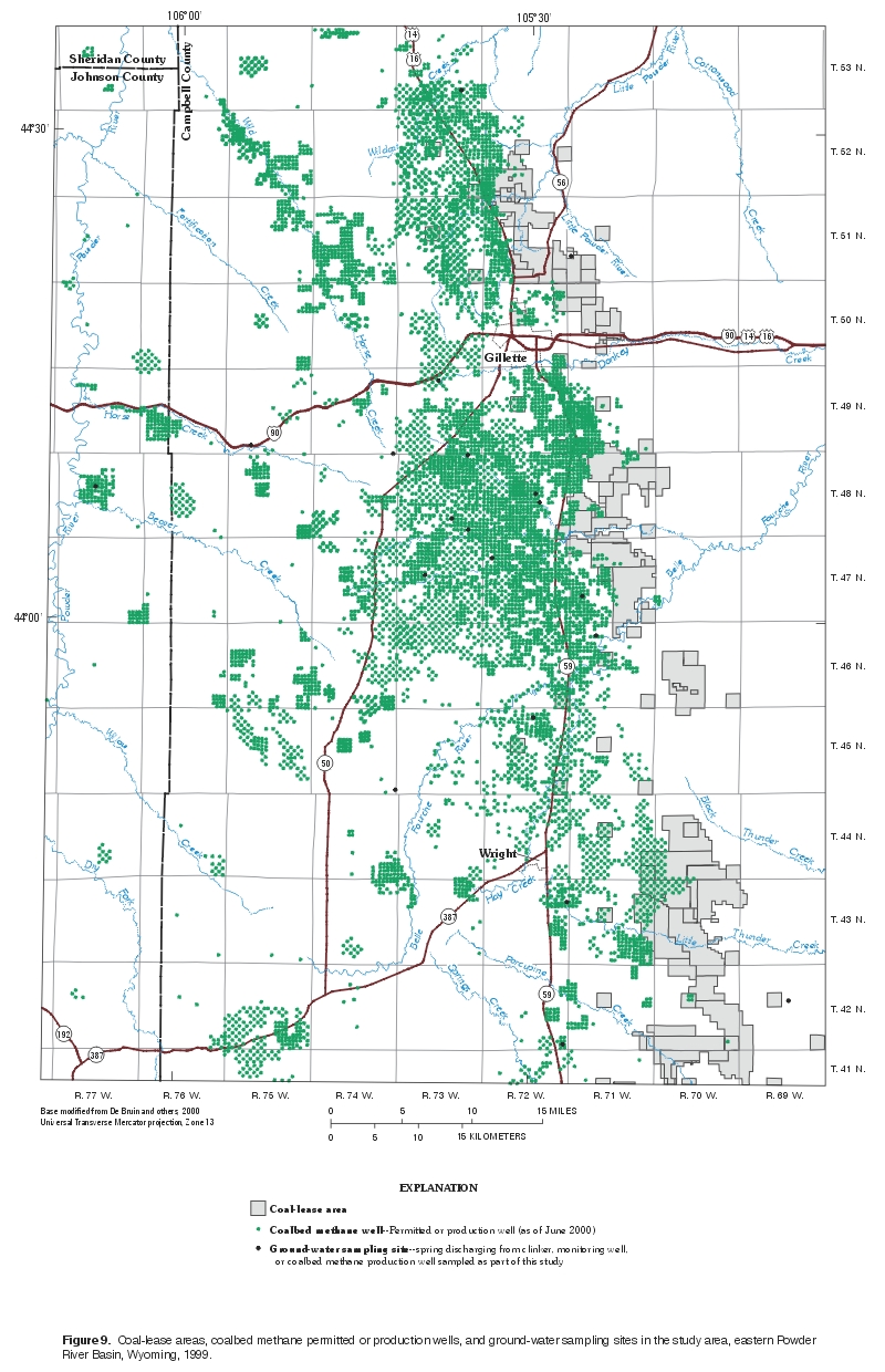
Figure 9. Coal-lease areas, coalbed methane permitted or production wells, and ground-water sampling sites in the study area, eastern Powder River Basin, Wyoming, 1999. (Click on image for a larger version, 477 kb) |
Recently, there has been increased interest in the potential for coalbed methane production in the Powder River Basin. Methane suspected to be related to coal beds in the Powder River Basin in Wyoming was first reported by Olive (1957). Subsequently, Whitcomb and others (1966) and Lowry and Cummings (1966) published gas analyses from several water wells in the Powder River Basin in Wyoming indicating high concen-trations of methane. Commercial extraction of coalbed methane began in the mid- to late-1980's in the Powder River coal field (Jones and De Bruin, 1990). Extraction greatly increased around 1997, when over 200 coalbed methane wells were in production and monthly methane production reached one billion cubic feet (De Bruin and Lyman, 1999). Since then, development continues rapidly as "the coalbed methane play in the Powder River Coal Field is currently the most active gas play in the United States" (De Bruin and Lyman, 1999, p. 67). More than 3,000 wells have been drilled as of July 2000, many more have been permitted (fig. 9), and thousands more are expected to be installed in the future.
Methane is removed from the coal by pumping water (dewatering) from coalbed methane production wells installed in coal beds. The wells are completed by installing well casing to the top of the coal bed, reaming the coal bed, and then leaving the coal bed open to the hole. Water is then removed from the well by installing a submersible pump in the open coal bed; pumping reduces hydrostatic pressure in the coal that allows the methane to be released (desorption). The gas is transported to the surface in the space between the tubing attached to the submersible pump and the well casing and the produced water is discharged to the surface via the tubing.
Because of the importance of the coal and gas resources in the area, many studies of the geology and hydrogeology of the area have been, and continue to be conducted. The rapid development of the Wyodak-Anderson coal zone as a source of coalbed methane has renewed interest in hydrologic processes throughout the Powder River Basin.
The authors would like to thank all the people who supported this study, assisted with collection of ground-water-quality samples, and assisted with preparation of the report. Richard G. Stockdale of the WSEO and Mike Brogan and Joe Meyer of the BLM are gratefully acknowledged for their support of this study. Special thanks are given to Barrett Resources (now Williams Energy Services) who kindly gave permission to sample their coalbed methane production wells and provided assistance with the sampling of the wells. Ray Murphy and Larry Porter of the WSEO, and Joe Meyer and Mike Brogan of the BLM, kindly provided assistance with the sampling of the monitoring wells in the study. Ed Heffern (BLM) provided data and invaluable assistance for preparation of the map showing the distribution of clinker in the study area. Finally, the authors would like to thank U.S. Geological Survey colleagues Greg Boughton and Laura Hallberg for assisting in the collection and compilation of data used in the report, Cynthia A. Rice and Michael Cannon for providing colleague reviews, and Suzanne C. Roberts and Emily A. Sabado for preparation of illustrations and editorial assistance, respectively.
Well-completion information, water levels, and the identified aquifer for all wells sampled as part of this study are summarized in table 1. If a well was completed in the Wyodak-Anderson coal zone, individual coal beds within the zone were identified from well permits if possible. All but one of seventeen wells completed in a coalbed aquifer were in the Wyodak-Anderson coal zone or equivalent zone or bed (i.e., one well was completed in the Big George coal bed); well C15 was suspected to be completed in a coal bed located below the zone. Well locations are shown on figure 8.
Water levels were measured in all monitoring wells prior to sampling, including one monitoring-well cluster comprising three wells completed successively deeper in the Wasatch aquifer and five monitoring-well clusters comprising two wells each (one well completed in the Wasatch aquifer and one well completed successively deeper in the Wyodak-Anderson coalbed aquifer) (table 1). A monitoring-well cluster is a series of wells located close to each other where each well is drilled and completed at a different depth. Water levels measured in successively deeper wells completed as part of a well cluster can be used to evaluate the hydraulic potential (differences in hydraulic head) for vertical ground-water flow at the location. There was a relatively strong vertical gradient within the Wasatch aquifer at the site of the well cluster (table 2) containing wells W3, W4, and W5. The decreasing hydraulic head with depth indicates that there was a hydraulic potential for downward ground-water flow in the Wasatch aquifer in the vicinity of this location if geologic conditions allow. There was a downward vertical gradient from the Wasatch aquifer to the Wyodak-Anderson coalbed aquifer as measured in three of the four well clusters (table 2) that were completed in both zones. This decreasing hydraulic head between aquifers indicated the potential for downward vertical flow from the Wasatch aquifer to the underlying Wyodak-Anderson coalbed aquifer. The fourth well cluster indicated hydraulic head increases with depth at one well cluster (table 2, wells W8 and C17), indicating an apparent hydraulic potential for upward ground-water flow, based on a water level measured below land surface in a well completed in the Wasatch aquifer (W8) and a flowing well discharging a mixture of gas and water completed deeper in the underlying Canyon coal bed of the Wyodak-Anderson coalbed aquifer (C17). The hydraulic potential for vertical ground-water flow could not be evaluated in one well cluster (wells W6 and C14) because the well completed in the Wasatch aquifer (W6) had just been installed and well development recently completed; therefore, the water level was not used because it did not represent the static water level in the aquifer.
It should be noted that all of these monitoring-well clusters are located within active coalbed methane production fields (fig. 9) and areas of coal mining. Significant drawdown has been observed in the Wyodak-Anderson coalbed aquifer in some of these areas as a result of both of these activities (Meyer, 1999); therefore, water levels measured in these monitoring wells may have been affected depending on hydraulic connection between the individual wells in the clusters. However, a downward vertical gradient in the Wasatch and Fort Union Formations in the study area prior to much development has been noted previously (Ground-Water Subgroup, 1974; Davis, 1976). In addition, the water-level measurements represent a discrete measurement at one point in time and water levels may vary with time.