In the dumpsite area, the irregularity of the sea bottom, characterized by surficial boulders, hills, hillocks, depressions, and faulted sedimentary strata, is similar to submarine landslide deposits off Hawaii (Lipman and others, 1988), parts of submarine debris flows (Prior and others, 1984), and to deposits created by subaerial debris avalanches (Siebert, 1984; Francis and Wells, 1988). This area shows a complex geologic history of localized events requiring closely-spaced profiles and images to outline the separate units.
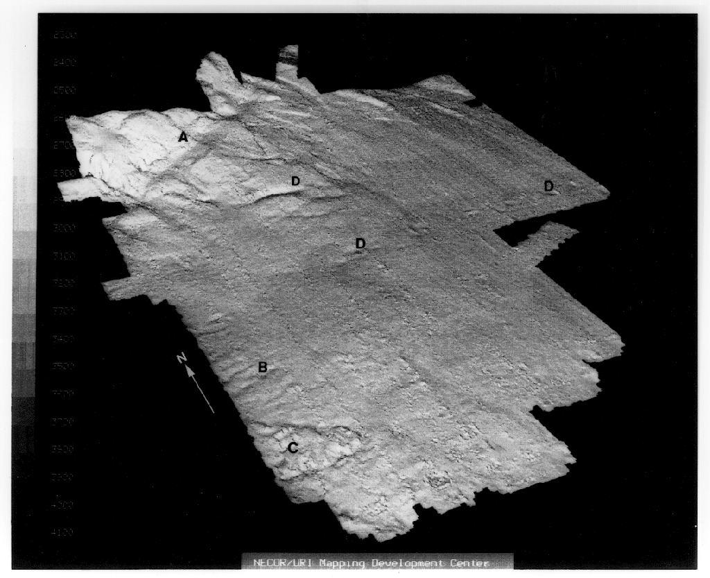
The perspective view of the Sea Beam bathymetry data shows the trough along the base of the slope (A) and the lobate, mounded deposits to seaward of it on the uppermost rise (compare the seabeam bathymetric map).
The origin of the slope-base trough is not well understood. Similar slope-base morphology is found along the northeast U.S. continental slope (Dennis O'Leary, personal commun., 1989). In places it appears to be formed by a reverse slope behind blocky landslide deposits which slid from the continental slope. In other places, surface strata of the rise appear to be truncated by the slope-base trough, and the trough may be an erosional feature, created by downslope-traveling flows at the change in slope (Ryan and Farre, 1981, Farre and Ryan, 1987). Its continuity along the slope base and across inter-canyon areas gives it a different character from subaerial avalanche impact pools, which are small circular pools not uncommonly found at the base of avalanche chutes along mountain fronts (Corner, 1980), and from depressions at the mouths of submarine canyons off Malta described by Biju-Duval and others, (1983). Many seismic profiles in this area and to the southwest show older (buried) trough and mound morphology at the slope base (Robb, 1986) that imply a repetetive or long-term process.

The broad lows extending seaward from slope canyons or valleys that have high-backscatter sidescan-sonar characteristics (showing fine-scale roughness of the sea bottom; evidenced by 120-kHz sonar images) were interpreted from their 3.5-kHz signature (prolonged echo with absent or discontinuous subbottom reflections) to be underlain by turbidites by Pratson and Laine (1989). The offshore-trending furrows observed by the 120 kHz deep-towed system may have been formed by passage of sediment gravity flows that appear unchannelized to less resolved observation. Alternatively, those features may be longitudinal furrows such as are commonly observed on large landslide surfaces.
In either case, the sidescan-sonar data and 3.5-kHz sub-bottom profiles show that the furrowed suface is covered in places by subsequent deposition. The low-backscatter tongue-like feature on the GLORIA images is shown by 3.5 kHz profiles to coincide with a surficial mud flow and by the 120 kHz sidescan sonar data to have a smooth surface. It is possible that both of these features were produced during a single slide episode. If landslides or sediment gravity flows that are competent to transport boulder-sized rock clasts occur in the present-day, they would bury, or resuspend, remove, and redistribute waste dumps or structures of interest to man. The boulders on the rise have rounded forms and weathered surfaces which suggest they may be old in their present locations. On the other hand, drums of radioactive wastes that were dumped as recently as the 1950s appear to be half buried in the sediment surface like most of the boulders (Ryan and Farre, 1983), and some of the boulders appear to be on the surface. So the question of when the boulders arrived remains open to examination. Similarly not known are when (or how) the offshore-trending furrows and ridges observed by deep-towed sidescan sonar were created, or when the overlying, later debris flow deposit was emplaced.
The major morphology of this submarine landscape may be of Pleistocene origin, presumably linked to low sea levels, greater sediment input and generation of turbidity currents at a shoreline near the shelf edge, and consequent erosion and slumping on the continental slope. The GLORIA mosaic of the entire East Coast continental rise shows features predominantly caused by offshore-directed sediment transportation, either by mass-movement (landslide) or sediment gravity flow. There is little evidence in the sea-floor morphology of the mostly low-velocity boundary currents measured by bottom current meters in the present day (Fry and Butman, 1991).
An apparent discrepancy between geomorphologic evidence for offshore-directed transport and the measured present-day low-velocity contour-parallel currents is probably due to a short-term observational window of the current measurements. The present-day regime of dominantly contour-parallel currents has been present for less than 25,000 years. Although the meter-thick covering of recent sediments that those currents have moved about on the sea floor has not concealed the larger features that survive from a more active past environment, it might be expected to have filled and smoothed the microfeatures. Further investigation is required to distinguish and measure the frequency and geologic impact of events that occur episodically and that can be significant and dangerous to man's use of the sea floor.

