| |  |  | | Lake Pontchartrain Atlas: | | | | | | | | | | | | | | | | | | | | | | | | | | | | | | | Environmental Issues |  | | | | | | | | | | | | | |  | | | | | | | | | | |  | Environmental Issues - Urbanization Contributors: Beall, Peters | Lake Pontchartrain Basin Farmland 1992 | 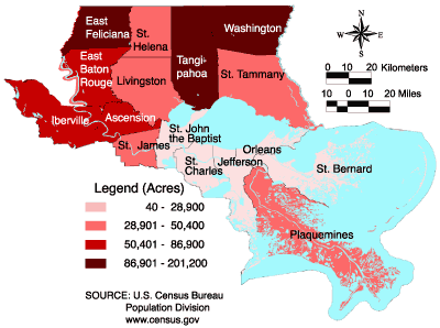 | Parish | Farmland (Acres) | | Ascension* | 63,446 | | East Baton Rouge | 79,150 | | East Feliciana | 136,812 | | Iberville* | 81,401 | | Jefferson* | 4,127 | | Livingston | 36,059 | | Orleans* | 100 | | Plaquemines* | 46,110 | | St. Bernard | 6,166 | | St. Charles* | 23,185 | | St. Helena | 50,319 | | St. James* | 42,922 | | St. John the Baptist* | 17,347 | | St. Tammany | 40,181 | | Tangipahoa | 126,886 | | Washington | 116,221 | | * West banks of these parishes are not included in the Lake Pontchartrain Basin. | | | Figure 22: Acres of farmland (by parish) in the LPB for 1992. | | Lake Pontchartrain Basin Farmland 1997 | 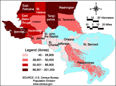 | Parish | Farmland (Acres) | | Ascension* | 55,270 | | East Baton Rouge | 66,008 | | East Feliciana | 115,153 | | Iberville* | 96,407 | | Jefferson* | 4,836 | | Livingston | 40,471 | | Orleans* | 41 | | Plaquemines* | 36,756 | | St. Bernard | 3,404 | | St. Charles* | 21,338 | | St. Helena | 65,741 | | St. James* | 45,347 | | St. John the Baptist* | 9,538 | | St. Tammany | 41,863 | | Tangipahoa | 120,022 | | Washington | 100,006 | | * West banks of these parishes are not included in the Lake Pontchartrain Basin. | | | Figure 23: Acres of farmland (by parish) in the LPB for 1997. | | Lake Pontchartrain Basin % Farmland Change 1992-1997. | 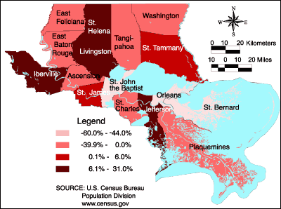 | Parish | Percent Change | | Ascension* | -12.9 | | East Baton Rouge | -16.6 | | East Feliciana | -15.8 | | Iberville* | 18.4 | | Jefferson* | 17.2 | | Livingston | 12.2 | | Orleans* | -59.0 | | Plaquemines* | -20.3 | | St. Bernard | -44.8 | | St. Charles* | -8.0 | | St. Helena | 30.7 | | St. James* | 5.7 | | St. John the Baptist* | -45.0 | | St. Tammany | 4.2 | | Tangipahoa | -5.4 | | Washington | -14.0 | | * West banks of these parishes are not included in the Lake Pontchartrain Basin. | | | Figure 24: The percent of farmland change (by parish) between the years 1992 and 1997 for the LPB. | | Lake Pontchartrain Basin Average Farm Values* 1997 | 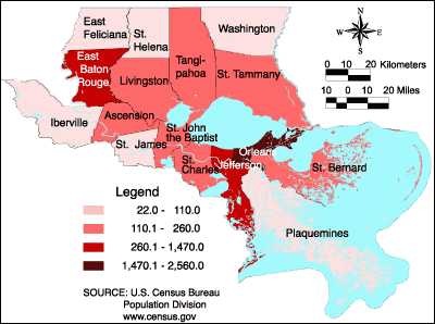 | Parish | Farm Value** | | Ascension* | $2,047 | | East Baton Rouge | $1,912 | | East Feliciana | $1,548 | | Iberville* | $1,661 | | Jefferson* | $1,823 | | Livingston | $2,695 | | Orleans* | $20,710 | | Plaquemines* | $1,219 | | St. Bernard | $2,384 | | St. Charles* | $1,610 | | St. Helena | $1,251 | | St. James* | $1,506 | | St. John the Baptist* | $2,200 | | St. Tammany | $3,530 | | Tangipahoa | $2,219 | | Washington | $1,922 | * West banks of these parishes are not included in the Lake Pontchartrain Basin.
** Farm value is the average value of all land and buildings per acre of land. | | | Figure 25: The average farm values* (by parish) for the LPB in 1997. | « Previous | Next » |
