Coastal & Marine Geology Program
>
Center for Coastal & Regional Marine Studies
> Environmental Atlas of Lake Pontchartrain
Environmental Atlas of the Lake Pontchartrain Basin
Lake Pontchartrain Atlas Home
Lake Pontchartrain Atlas:
Preface
Table of Contents
Introduction
Environmental Overview
Environmental Status & Trends
Restoration
Physical Environments
Basin Geology
Biological Resources
Environmental Issues
Bibliography
Resources
Contributors
Acronyms
Contact:
Jack Kindinger
Environmental Issues:
Coastal Land Loss
|
Shoreline Change and Rates
|
Urbanization
|
Aggregate Dredge Holes
|
Dredge Pit Characterization
|
Bonnet Carré Diversion
|
Water Quality
|
Sediment Quality & Dispersal
Environmental Issues - Shoreline Change and Shoreline Change Rates
Contributors: Zganjar, Westphal, Penland
Introduction
Shoreline Changes of Lake Maurepas
Shoreline Change Rates of Lake Maurepas
Shoreline Changes of Northern Lake Pontchartrain
Shoreline Change Rates of Northern Lake Pontchartrain
Shoreline Changes of Southern Lake Pontchartrain
Shoreline Change Rates of Southern Lake Pontchartrain
Shoreline Changes of Lake Borgne
Shoreline Change Rates of Lake Borgne
Shoreline Changes of the Northern Chandeleur Islands
Gulfside Shoreline Change Rates of the Northern Chandeleur Islands
Bayside Shoreline Rates Changes of the Northern Chandeleur Islands
Shoreline Changes of the Southern Chandeleur Islands
Gulfside Shoreline Change Rates of the Southern Chandeleur Islands
Bayside Shoreline Change Rates of the Southern Chandeleur Islands
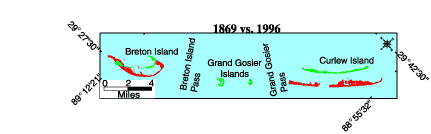
Figure 15a:
1869 vs. 1996
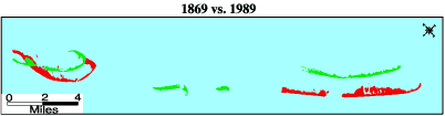
Figure 15b:
1869 vs. 1989
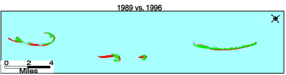
Figure 15c:
1989 vs. 1996
Figure 15:
Shoreline position maps of the Southern Chandeleur Islands comparing the years
a)
1869 and 1996,
b)
1869 and 1989, and
c)
1989 and 1996.
«
Previous
|
Next
»
Coastal & Marine Geology Program
>
Center for Coastal & Regional Marine Studies
> Environmental Atlas of Lake Pontchartrain
email
Feedback
[an error occurred while processing this directive]