| |  |  | | Lake Pontchartrain Atlas: | | | | | | | | | | | | | | | | | | | | | | | | | Basin Geology |  | | | | | | | | | | | | | | | | | | | |  | | | | | | | | | | |  | Basin Geology - Bathymetry Contributors: Connor, Jr., Maygarden, Penland 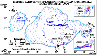 | | Figure 35: Bathymetric contour map. Click on the image for a larger version. | This bathymetric contour map was constructed by processing and computer-generating historic hydrographic data published by NOAA in the early and middle 1900's (Figure 35). The bathymetric map shows a series of four holes in the floor of Lake Pontchartrain along the New Orleans shoreline between West End and the Lakefront Airport. Two large, elongated holes more than 10 meters (32.8 ft.) deep are shown parallel to the shoreline and two smaller but deeper holes occur at the mouth of the IHNC. These holes were created by hydraulically dredging billions of cubic yards of hydraulic fill to create 2,000 acres of new land. This project, which took place between 1926 and 1930 was designed by the New Orleans Levee Board to protect the city shoreline from erosion and flooding. Residential neighborhoods, the UNO, federal, military and commercial property now occupy this property. Natural accretion by wave and tidal movement has since significantly reduced the depth of the two holes parallel to the shore. Material from dredge pits at the mouth of the IHNC and at the present location of South Shore Harbor was used to build the apron and runway of Lakefront Airport, which was completed in 1934. Natural tidal scouring maintains the depth of the holes at the mouth of the IHNC. Also featured on this map are deep pits at the mouths of Rigolets and Chef Passes. These are created and maintained by natural tidal scouring action. « Previous | Next » |
