| |  |  | | Lake Pontchartrain Atlas: | | | | | | | | | | | | | | | | | | | | | | | | | Basin Geology |  | | | | | | | | | | | | | | | | | | | |  | | | | | | | | | | |  | Basin Geology - Geologic Resources Contributors: McCorquodale, Barbé, Wang, Carnelos The estimated fresh water average annual inflows from all drainage units to the Lake Pontchartrain system are summarized in Table 4, below. The inflows consist of tributary flows (Figures 38, 39, and 40), direct rainfall on the Lakes and storm water that is pumped from the east back of the New Orleans urban area. The outflows consist of the net flow to the Gulf of Mexico and evaporation from the Lake surface (Figure 41). Table 4 also shows the runoff flow per unit area of the tributary drainage basins. This varies significantly from approximately 0.4 cfs/mi2 to over 3 cfs/mi2 where the low values are generally in the low relief areas and the higher values are in urban or higher relief areas. Table 4 excludes diversions and leakage from the Mississippi River through the Bonnet Carré Spillway and minor flows through the locks on the MRGO. A typical Spillway opening can increase the annual flow for that year by approximately 12,500 cfs. The Spillway has been opened for a major flood diversion eight times since 1937, or approximately every seven or eight years. In addition, there is leakage through the Spillway when the Mississippi is at a high stage. There may be some groundwater flow that directly enters Lake Pontchartrain, but this quantity is not known at this time. Sea-level rise and subsidence vary from 1 to 10 mm/year which may result in an annual change in the volume of the lake system of about 0.01 km3. | Table 4: Preliminary Annual Fresh Water Budget | | | Area
(mi2) | Average Annual
Flow (cfs) | Flow/Area
(cfs/mi2) | Precipitation
(inches) | Potential
Evapo-
transpiration
(inches) | | Tributaries | | | Pearl River | 8,669 | 10,118 | 1.2 | | | | Amite River | 1,819 | 2,146 | 1.2 | | | | Tangipahoa River | 771 | 1,194 | 1.5 | | | | Tickfaw River | 727 | 345 | 0.5 | | | | Tchefuncte River | 450 | 166 | 0.4 | | | | Blind River | 412 | 375 | 0.9 | | | | Bayou Lacombe | 96 | 53 | 0.6 | | | | Bayou Bonfouca | 73 | 148 | 2.0 | | | | Urban | 63 | 185 | 3.0 | | | | Bonnet Carré Spillway | 11 | 12 | 1.1 | | | | Bayou Chinchuba | 10 | 11 | 1.1 | | | | Bayou Castine | 8 | 10 | 1.2 | | | | Others (Marshes and Swamps) | 432 | 159 | 0.4 | 62 | 57 | | Open Water | | | Lake Pontchartrain Area | 632 | 2,886 | 4.6 | 62 | | | Lake Borgne Area (Malheureux Point) | 215 | 981 | 4.6 | 62 | | | Lake Maurepas Area | 90 | 413 | 4.6 | 62 | | | Total Freshwater Inflow | 14,480 | 19,203 | 1.3 | | | | Outflows | | | Loss due to ET from Lake Pontchartrain | 632 | 2,607 | 4.1 | | 56 | | Loss due to ET from Lake Borgne | 215 | 886 | 4.1 | | 56 | | Loss due to ET from Lake Maurepas | 90 | 373 | 4.1 | | 56 | | Net Outflow to Gulf of Mexico | | 15,336 | | | | |
Table 4: Preliminary annual fresh water budget. ET=evapotranspiration. 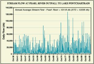 | | Figure 38: The USGS has historically measured the daily flow at five tributaries to Lake Pontchartrain. A typical daily flow for the Pearl River is shown. There is a large variation in the daily flow in the range of about 1,000 cubic feet per second (cfs) to 130,000 cfs. | 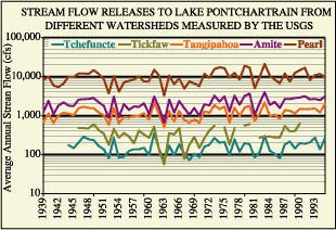 | | Figure 39: The annual flows for the Tchefuncte, Tickfaw, Tangipahoa, Amite and Pearl Rivers are given for the periods of record. The Pearl, Tangipahoa and the Amite Rivers have flow measurements dating back to 1939. | 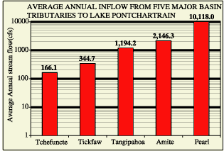 | | Figure 40: The average annual flows for the Tchefuncte, Tickfaw, Tangipahoa, Amite and Pearl are given for the periods of record for these rivers. | 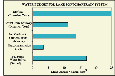 | | Figure 41: The water budget for the Lake Pontchartrain system. | « Previous | Next » |
