|
 |
 |
Primary Products - Overview Maps & Evolution Overview:
|
|
|
|
|
|
|
|
|
|
|
|
|
|
|
|
|
|
|
|
 |
|
|
|
|
|
|
|
|
|
|
|
|
|
|
|
Tile 1
Carysfort Reef: Carysfort Reef (Holocene) caps a section of the Pleistocene shelf-edge reef about 9 km northeast of the Tile 1 sector and is included in the Tile 1 discussion because of its abundant geologic data (Figs. 22B, 27). A 1991 seismic profile (Lidz et al., 1997a; Lidz et al., 2003) is in this report (Fig. 35). Holocene reefs at Carysfort have been well studied (e.g., Dustan, 1985; Dustan and Halas, 1987; Fig. 3E). The Carysfort area is geologically important for several reasons.
Seismic records indicate the presence of an outlier reef (e.g., Lidz et al., 1991) and backreef trough seaward of Carysfort Reef (Fig. 35). The outlier reef and associated trough are distinctly different in shape, width, and depth from outlier reefs and troughs off Rock Key and Sand Key Reefs in the lower Keys (Fig. 18; Lidz et al., 2003). The differences imply that the outlier reefs in the two areas represent two separate reef tracts. Depth to bedrock in the trough behind the Carysfort outlier reef is 24 m below sea level. Depth to bedrock in troughs behind the lower Keys outlier reefs (i.e., the present upper-slope terrace) is 30 to 40 m below sea level. The present terrace extends seaward of the Carysfort outlier reef. These differences indicate that the Carysfort outlier reef grew on a shallower, more landward outer-shelf terrace than the lower Keys outlier reefs. Four tracts of outlier reefs initially began accretion on the present terrace region-wide (Lidz et al., 1991; Lidz, et al., 2003). Seismic facies indicate buried remnants of the incipient tracts seaward of the Carysfort outlier (Fig. 35). The shallow landward terrace behind the Carysfort outlier may indicate the presence of other such terraces concealed beneath the coral reefs. Coral reefs and reef rubble transmit acoustic energy poorly, thus obscuring seismic reflections that would identify underlying stratigraphic horizons or rock surfaces. The youngest pre-Holocene age recorded so far anywhere along the Pleistocene shelf-edge reef was obtained on a coral
cored from the seaward face of the reef beneath Carysfort Reef. High-precision radiometric dating indicates that the coral is 77.8 ka (Fig. 36A; Multer et al., 2002). Radiometric dates from the Carysfort outlier reef indicate that corals there range in age from ~94.4 to 92.2 ka, from 85.3 to 80.2 ka, and from 7.6 to 5.0 ka (Toscano, 1996; Toscano and Lundberg, 1998). In time, after sediments bury the margin at Carysfort Reef, a silhouette of its surface in the rock record could resemble a simple, prograded margin, or a margin that has advanced seaward by sediment streaming over the edge (Fig. 36B). However, because sediments would conceal Carysfort Reef, its outlier reef, and their backreef troughs, examination of subsurface features in a seismic profile would reveal opposing dip directions within the surface sediments. Based on dip direction alone and absent evidence of ocean location, direction of margin accretion could be misinterpreted in the geologic record (Lidz, 2004).
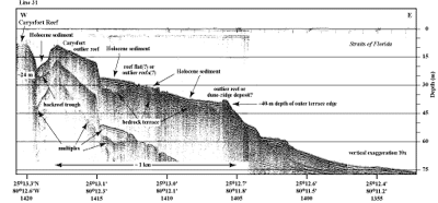
Figure 35. Seismic profile (1991) shows shelf-margin features at Carysfort Reef (from Lidz et al., 2003; Fig. 27). Note that water depth to bedrock in the trough behind the Carysfort outlier reef (24 m) is less than the depth (30-40 m) of the present seaward upper-slope bedrock terrace. Shapes of geologic features in this area are different from those at Sand Key Reef (Fig. 18). The Carysfort outlier reef is thought to represent a different tract of outlier reefs than the tracts seaward of Sand Key (Toscano and Lundberg, 1998; Lidz et al., 2003). 'Multiples' are an artifact common in seismic-reflection data. These reflections replicate those of existing, overlying, geologic surfaces and should not be regarded as representing any subsurface stratigraphic horizon. Latitude and longitude in degrees and decimal minutes based on GPS coordinates. Hours (military time) below coordinates serve as navigational correlation points along seismic line. [larger version] |
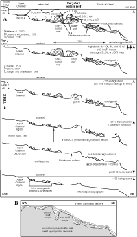 Figure 36. (A) Model shows shelf and margin evolution in the area of Carysfort Reef, based on seismic-reflection and coral-age data (ages >125 ka modified from Lidz, 2004). Horizontal scale and vertical exaggeration apply to features at and seaward of the shelf margin based on the seismic profile (Fig. 35; Lidz et al., 2003). Shelf features are based on the Marker G core transect across two coral ridges (Fig. 34A; Shinn et al., 1977a) and are not drawn to scale. Up arrows indicate the seven periods of sea-level highstands that produced coral reef ecosystems on the Florida shelf in the last 325 ka. Ls = limestone. ka = thousands of years. Holocene = the most recent 10 ka. Q1-Q5 Units = names assigned by Perkins (1977) to the five marine sections that compose the most recent part of the south Florida Pleistocene rock record. Marine-isotope substages refer to periods of time that correspond to major changes in the paleotemperature record (Fig. 37A, 37B). Short curved arrows indicate landward sediment transport and infilling of backreef troughs. (B) With continued sedimentation, the future geologic record at the Carysfort outlier reef would show a progradational margin with multiple lateral sections of landward- and seaward-dipping beds on either side of two buried, parallel, coral reef trends. The buried reef trends would represent a coalesced reef-complex margin (Lidz, 2004). [larger version] Figure 36. (A) Model shows shelf and margin evolution in the area of Carysfort Reef, based on seismic-reflection and coral-age data (ages >125 ka modified from Lidz, 2004). Horizontal scale and vertical exaggeration apply to features at and seaward of the shelf margin based on the seismic profile (Fig. 35; Lidz et al., 2003). Shelf features are based on the Marker G core transect across two coral ridges (Fig. 34A; Shinn et al., 1977a) and are not drawn to scale. Up arrows indicate the seven periods of sea-level highstands that produced coral reef ecosystems on the Florida shelf in the last 325 ka. Ls = limestone. ka = thousands of years. Holocene = the most recent 10 ka. Q1-Q5 Units = names assigned by Perkins (1977) to the five marine sections that compose the most recent part of the south Florida Pleistocene rock record. Marine-isotope substages refer to periods of time that correspond to major changes in the paleotemperature record (Fig. 37A, 37B). Short curved arrows indicate landward sediment transport and infilling of backreef troughs. (B) With continued sedimentation, the future geologic record at the Carysfort outlier reef would show a progradational margin with multiple lateral sections of landward- and seaward-dipping beds on either side of two buried, parallel, coral reef trends. The buried reef trends would represent a coalesced reef-complex margin (Lidz, 2004). [larger version] |
All coral dates in the Carysfort area and elsewhere along the reef tract correlate with times and relative positions of past (paleo-) global sea levels (Fig. 37A, 37B). All coral-age and global paleotemperature-curve data indicate that the Florida shelf was exposed from about 77.8 to 9.6 ka (radiometric dates of Multer et al., 2002, and Mallinson et al., 2003, respectively).
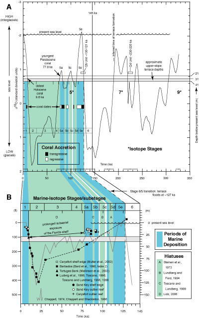
Figure 37. (A) Marine oxygen-isotope paleotemperature curve of Imbrie et al. (1984) shows high and low stands of global sea level over the past 350 ka with select Florida data added. Variation in δ18O mainly reflects changes in sea level due to waxing and waning of continental ice sheets during glacial/interglacial cycles. Note periods of transgressive (black boxes representing dated-coral ages) and regressive (white boxes) coral accretion. Shaded bar represents depths (~30-40 m) of present upper-slope terrace beneath the outlier reefs, as based on actual depths (21 and 31 m) of corals with respective radiometric ages of 77.8 and 9.6 ka (Multer et al., 2002; Mallinson et al., 2003). Closely spaced tick marks at bottom represent 1-ka intervals. Q Units are marine stratigraphic sections of Perkins (1977); dates are from Multer et al. (2002) and Muhs et al. (2004). The Q3 unconformity is a prominent stratigraphic horizon and is found everywhere in south Florida. The Q4 unconformity is less evident and is more difficult to identify. Inferred time of upper-slope terrace formation (~175 ka) of Lidz et al. (2003) is revised to ~190 ka in Lidz (2006). (B) Detailed record of sea-level change during the last glacial/interglacial cycle over the past 150 ka (modified from Ludwig et al., 1996) relative to depth of the upper-slope terrace (shaded horizontal bar). Marine oxygen-isotope Stages (6-1) and Stage 5 substages (5e-5a) are periods of time that represent variations in oceanic temperatures coincident with high or low sea levels. Hiatuses represent gaps in the rock record (Fig. 7B). Hiatuses or gaps in Florida isotopic data correlate with sea-level lowstands that would likely manifest as subaerial-exposure surfaces or unconformities in the geologic record (see Fig. 5B for definitions). Gray curve was derived from dating of tectonically uplifted coral reefs on the Huon Peninsula, New Guinea, and is shown for comparison with coral-age data from Barbados (dashed line) and tectonically stable Florida (triangles, circles, and plus signs). Approximate durations of substages within Stage 5 are: 5e (127-116 ka), 5d (116-108 ka), 5c (108-96 ka), 5b (96-86 ka), and 5a (86-75 ka). The Key Largo Limestone reef (middle and upper Florida Keys) and Miami Limestone oolite units (lower Florida Keys and beneath Miami) developed during substage 5e. The largest outlier reef seaward of Sand Key Reef contains corals that date to substages 5c, 5b, and 5a and the Holocene, or Stage 1 (Ludwig et al., 1996; Toscano, 1996; Toscano and Lundberg, 1998, 1999). The horizontal line (at ~30 m below present sea level) represents the highest elevation of the present upper-slope terrace on which the outlier reefs grew (Lidz et al., 1991; Lidz et al., 2003). All datasets and coral ages point to subaerial exposure of the outer Florida shelf (for ~68 ka) and the paleoplatform interior (for >100 ka) between substage-5a time and the Holocene (Lidz, 2006; Lidz et al., 2006). [larger version] |
How do we know when past sea levels (Fig. 37A) were high and when they were low? Past ocean-temperature curves have been developed from variations in oxygen-isotope ratios measured in shells of fossil planktonic or free-swimming protozoans called foraminifera (see Open-File Report 02-192). Planktonic foraminifera build their shells from calcium carbonate in seawater and occur in marine sediments globally. Ratios of oxygen isotopes within the shell material vary depending upon the water temperatures and depths at which the organisms lived (e.g., Emiliani, 1966; Lidz et al., 1968). The fossils used to measure the isotope record come from deep-sea cores whose sediments have been collecting in undisturbed or chronologic layers for millions of years. This continuity of chronology, in combination with the chemistry of oxygen uptake by foraminifera, allows scientists to use the isotope record as a proxy for ancient ocean temperatures. Paleotemperature curves are used as a gauge for relative position of past sea levels, i.e., warm water temperatures equate to high sea levels, and cool water temperatures equate to glacial periods when ocean waters were locked up in ice and sea levels were low.
The abundant information available for the Carysfort Reef area has enabled construction of an evolutionary cross-sectional model for that part of the Florida shelf and margin (Fig. 36; Lidz, 2004). The outer-shelf component of the model (seaward of Hawk Channel) was based on local knowledge of the shelf-wide coral-rock ridges, photographic evidence of the ridges (Figs. 33A, 33B), and data from the ridges drilled at Marker G (Shinn et al., 1977a; Fig. 34A). Examination of photomosaics (under a magnifying glass) and of zoomed-in scanned mosaics enabled differentiation of subtle shadings within the images—the basis for delineation of elevated hard substrate, adjacent sea grass, and carbonate sand. In many cases, Holocene patch reefs, clearly identifiable by surrounding sand haloes and other visible characteristics, verified presence and locations of the rock ridges. Patch reefs as small as ~10 m could be digitized on the ridges. The Marker G cores support the visual interpretation that the ridges are coral rock and are separated by sediment-filled swales (Fig. 34A).
The shelf-edge component of the model was based on the bedrock image or reflection visible in the seismic record off Pelican Shoal in the lower Keys (Lidz, 2004; Figs. 6C, 38). The image shows a broad, flat, upper-slope terrace fronting the Pleistocene shelf-margin reef. There is no seismic-reflection evidence that outlier reefs ever grew off Pelican Shoal. There is, however, seismic-reflection evidence of an elevated bedrock dune-ridge type of accumulation at the seaward edge of the terrace. To construct the evolutionary model for the Carysfort area, a 'generic' Pelican Shoal surface was modified to approximate seismic reflections of the bedrock at Carysfort (Fig. 36A, bottom panel). Then, using the reflection representing the bedrock surface as traced from the Carysfort seismic profile (Fig. 35), 'layers' simulating bedrock coral growth were added between the terrace and reef surfaces. Each layer was correlated with coral dates from the shelf-margin reef and the outlier reef (Fig. 36A, top panel) and with stands of interglacial sea levels that were sufficiently high to have flooded the shelf and margin (Fig. 37A). Lastly, the Holocene component was drawn from field knowledge. The crest of Carysfort Reef is too shallow for larger research vessels towing seismic gear to cross (Fig. 3E).
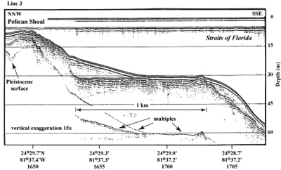
Figure 38. Seismic profile (1989) shows Pleistocene bedrock geology in the area of Pelican Shoal (from Lidz et al., 2003; Fig. 6C, Tile 6, lower Keys). Note wide, flat, upper-slope terrace with an elevated ridge at the seaward edge. This profile was used as the 'generic' surface on which evolutionary models of the shelf margin were based. Also note evidence of an old shoreline in Holocene sediment wedge at landward side of terrace. Horizontally bedded layers overlying inclined layers were probably eroded and redeposited in a tidal zone (Lidz et al., 2003). 'Multiples' are an artifact common in seismic-reflection data. These reflections replicate those of existing, overlying, geologic surfaces and should not be regarded as representing any subsurface stratigraphic horizon. Latitude and longitude in degrees and decimal minutes based on GPS coordinates. Hours (military time) below coordinates serve as navigational correlation points along seismic line. [larger version] |
Evolutionary models were similarly constructed for three other areas along the shelf (The Elbow—this tile; Pelican Shoal—Tile 6; and Sand Key Reef—Tile 7/8). However, the Holocene component for those models were drawn as traced from seismic profiles.
The trough behind the Carysfort outlier reef is only partially filled (Fig. 35). This unfilled trough contrasts with the trough behind The Elbow, located at the northeast edge of Tile 1 (Figs. 22B, 39A, 39B). Such differences arise from the highly variable transport processes and topography that typify the arc-shaped south Florida shelf, even over distances as short as a few kilometers.
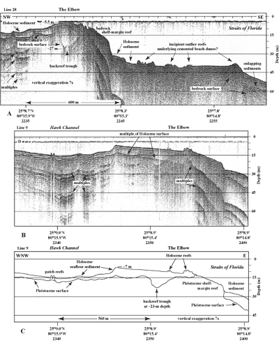
Figure 39. Seismic profiles (1991) show shelf-margin features at The Elbow (see Fig. 27 for trackline locations). (A) Trackline crossed perpendicular to the margin (modified from Lidz et al., 1997a, b). Note V-shaped backreef trough filled with sediments. Also note four areas of low-relief features on the upper-slope terrace. Similar features occur elsewhere on the upper Keys terrace (Fig. 35), indicating the features are linear. They are interpreted to represent immature coral (outlier) reefs because of their characteristic irregular surfaces. Compare with similar irregular surfaces of known (Holocene) reefs in (B) and (C). (B) Trackline crossed the margin at an oblique angle south of The Elbow Light (just north of profile in A). Note elongation or distortion of features due to angle of crossing (compare with true seismic images in profile A). Difference between broad or narrow depression can be the angle at which the seismic line intersects the depression (or any other type of subsurface feature). Oblique angle will make a depression look broader; a crossing normal to the same depression will make it look narrower. Also note the patch reefs on small, localized bedrock high in Hawk Channel. 'Multiples' are an artifact common in seismic-reflection data. These reflections replicate those of existing, overlying, geologic surfaces and should not be regarded as representing any subsurface stratigraphic horizon. D wave = direct arrival (not a geologic surface). Latitude and longitude in degrees and decimal minutes based on GPS coordinates. Hours (military time) below coordinates serve as navigational correlation points along seismic line. (C) Interpretation of Pleistocene and Holocene surfaces in profile (B). [larger version] |
continue to: The Elbow
|


