Data Series 860
1U.S. Geological Survey, St. Petersburg, FL 33701
2Contracted by the USGS, Baton Rouge, LA 70810
Publications are available from USGS Information Services, Box 25286, Federal Center, Denver, CO 80225-0046 (telephone 1-888-ASK-USGS e-mail: infoservices@usgs.gov).
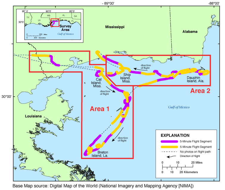
Figure 1. Map showing the baseline coastal oblique survey conducted August 8, 2012, from Dauphin Island, Alabama, to Breton Island, Louisiana. Full-size photographs are available online.
The images provided here are Joint Photographic Experts Group (JPEG) images. Exiftool was used to add the following to the header of each photo: time of collection, Global Positioning System (GPS) latitude, GPS longitude, keywords, credit, artist (photographer), caption, copyright, and contact information. The photograph locations are an estimate of the position of the aircraft and do not indicate the location of any feature in the images (see the Navigation Data page). These photographs document the configuration of the barrier islands and other coastal features at the time of the survey. Pages containing thumbnail images of the photographs, referred to as contact sheets, were created in 5-minute segments of flight time. These segements can be found on the Photos and Maps page. Photographs can be opened directly with any JPEG-compatible image viewer by clicking on a thumbnail on the contact sheet.
Table 1 provides detailed information about the GPS location, name, date, and time each of the 1,241 photographs taken along with links to each photograph. The photography is organized into segments, also referred to as contact sheets, and represent approximately 5 minutes of flight time. (Also see the Photos and Maps page).
In addition to the photographs, a Google Earth Keyhole Markup Language (KML) file is provided and can be used to view the images by clicking on the marker and then clicking on either the thumbnail or the link above the thumbnail. The KML files were created using the photographic navigation files.This report is divided into seven sections: Home, Abbreviations, Contents, Photos and Maps, Navigation Data, Logs, and Metadata. Links at the top and bottom of each page provide access to these sections. (If you are viewing this report on DVD, use a Web browser to open the file index.html.)
Links to the full-sized images can be found through the Photos and Maps page and through Table 1. KML files, Hypertext Markup Language (HTML) files, images used to produce the Web pages, and a readme file are also included in this report. Global Positioning System (GPS) data collected during the flight are also available in Navigation Data. The Logs pages contain information on the flight and the equipment used.
The Contents contains a diagram of the location of all files and folders mentioned in the text and provides links to these files and folders.
Figure 1. Baseline Coastal Oblique Aerial Photographs Area Map, August 08, 2012
Figure 2. Acquisition Geometry
Figure 3a. Area 1 - Baseline Coastal Oblique Aerial Survey from Pensacola, Fla., to Breton Island, La.
Figure 3b. Area 2 - Baseline Coastal Oblique Aerial Survey from Breton Island, La., to Pensacola, Fla.
Figure 4. Northern Benchmark Inset Map
Figure 5. Breton Island Inset Map
Figure 6. Dauphin Island Inset Map
Morgan, K.L.M., 2009, Coastal change during Hurricane Isabel 2003: U.S. Geological Survey Fact Sheet 2009-3025, 2 p., at https://pubs.usgs.gov/fs/2009/3025/.
Morgan, K.L.M., and Westphal, K.A., 2014, Baseline coastal oblique aerial photographs collected from Dauphin Island, Alabama, to Breton Island, Louisiana, August 8, 2012 : U.S. Geological Survey Data Series 860, https://dx.doi.org/10.3133/ds860.
Funding and (or) support for this study was provided by the USGS Coastal and Marine Geology Program (CMGP).
The authors wish to thank pilot Phillip McMiller for his assistance in data collection. This report benefited from the comments and reviews of Chris Reich and Noreen Buster with the USGS St. Petersburg Coastal and Marine Science Center (SPCMSC) - St. Petersburg, Fla.
This report was prepared by an agency of the United States Government. Although these data have been processed successfully on a computer system at the U.S. Geological Survey (USGS), no warranty expressed or implied is made regarding the display or utility of the data on any other system, nor shall the act of distribution imply any such warranty. The USGS shall not be held liable for improper or incorrect use of the data described and (or) contained herein. Reference herein to any specific commercial product, process, or service by trade name, trademark, manufacturer, or otherwise does not constitute or imply its endorsement, recommendation, or favoring by the United States Government or any agency thereof.
This report is readable on any computing platform that has standard Digital Versatile Disc (DVD) driver software installed. The minimum software requirements are a Web browser, a Portable Document Format (PDF) reader, and a text editor. Additional features are provided using Google Earth software (http://www.google.com/earth/download/ge/). If you cannot fully access the information on this page, please contact USGS Information Services at infoservices@usgs.gov or 1-888-ASK-USGS.
NOTE: Adobe Acrobat Reader or similar software is required to view PDF documents.
Karen L.M. Morgan
U.S. Geological Survey
St. Petersburg Coastal and Marine Science Center
600 4th Street South
St. Petersburg, FL 33701
Ph: (727) 502-8037
FAX: (727) 502-8182
kmorgan@usgs.gov

![]() U.S. Department of the Interior |
U.S. Geological Survey
U.S. Department of the Interior |
U.S. Geological Survey
URL: http://pubsdata.usgs.gov/pubs/ds/0860/ds860_title.html
Page Contact Information: GS Pubs Web Contact
Page Last Modified: Monday, 28-Nov-2016 19:32:15 EST
