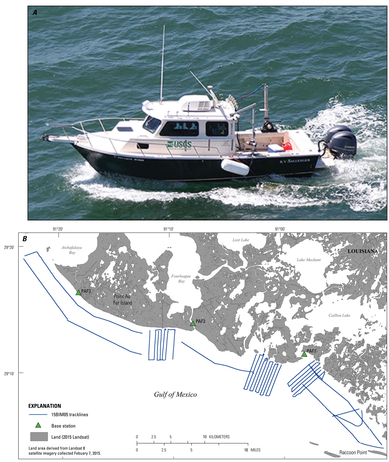
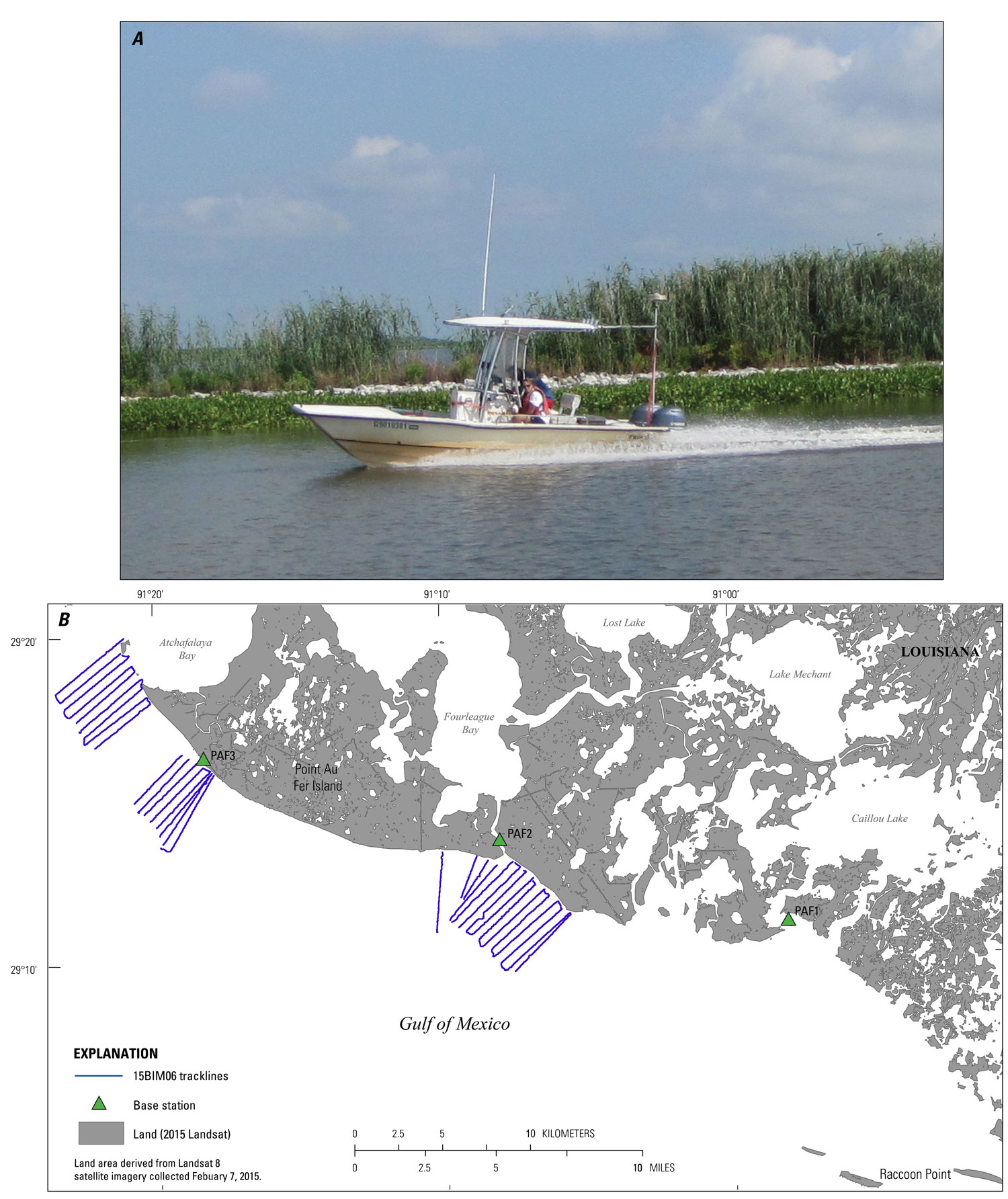
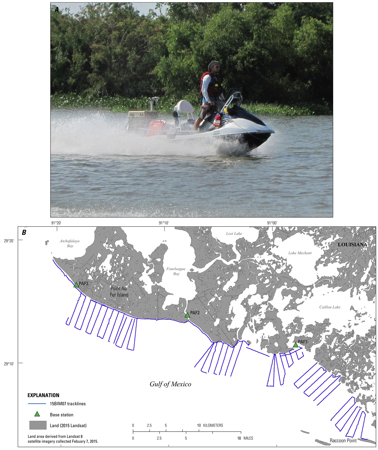
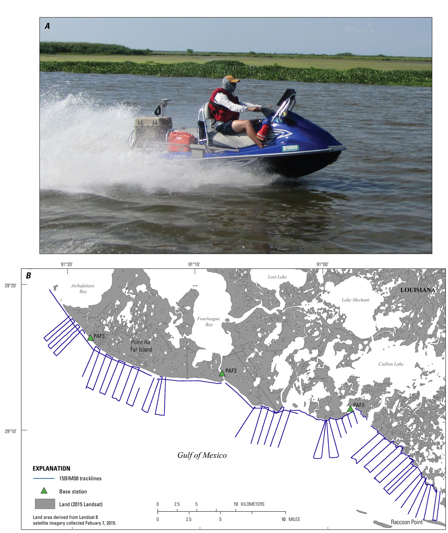
USGS - science for a changing world

Data Series 1041


Coastal Single-Beam Bathymetry Data Collected in 2015 from Raccoon Point to Point Au Fer Island, Louisiana

Skip Links

Citation Page
Abstract
Introduction
Survey Overview
Data Acquisition
Data Processing
Error Analysis
Survey Products
Data Downloads
Logs
Abbreviations
References Cited
 

Survey Overview

A single-beam bathymetric survey was conducted by the USGS St. Petersburg Coastal Marine Science Center within the shallow water coastal zone of south-central Louisiana, during July 22–29, 2015, under Field Activity Number 2015-320-FA (fig. 2). The survey area encompasses 307 square kilometers (km2), covering 64 kilometers (km) of shoreline, extending 4.5 km from the shoreface into the Gulf of Mexico. A total of 1,111.4 line-km of single-beam bathymetry (SBB) data were collected aboard 4 separate survey platform vessels including the 26-foot (ft) R/V Sallenger (cruise identifier 15BIM05, fig. 3), the 17 ft R/V Jabba Jaw (15BIM06, fig. 4), the R/V Shark (15BIM07, fig. 5), and the R/V Chum (15BIM08, fig. 6). Shore-perpendicular survey lines were spaced approximately 450 m apart and shore-parallel crossing lines were located as close to the shoreface as possible, 1 km from the shoreface and again at 4 km offshore (fig. 2). Ellipsoid heights were acquired and processed in the World Geodetic System of 1984 (WGS84) (G1150) Universal Transverse Mercator (UTM) zone 15N.

Trackline map overview for the 2015 Barrier Island Comprehensive Monitoring single-beam bathymetry survey along the southern coast of Louisiana, from Raccoon Point to Point Au Fer, Louisiana.
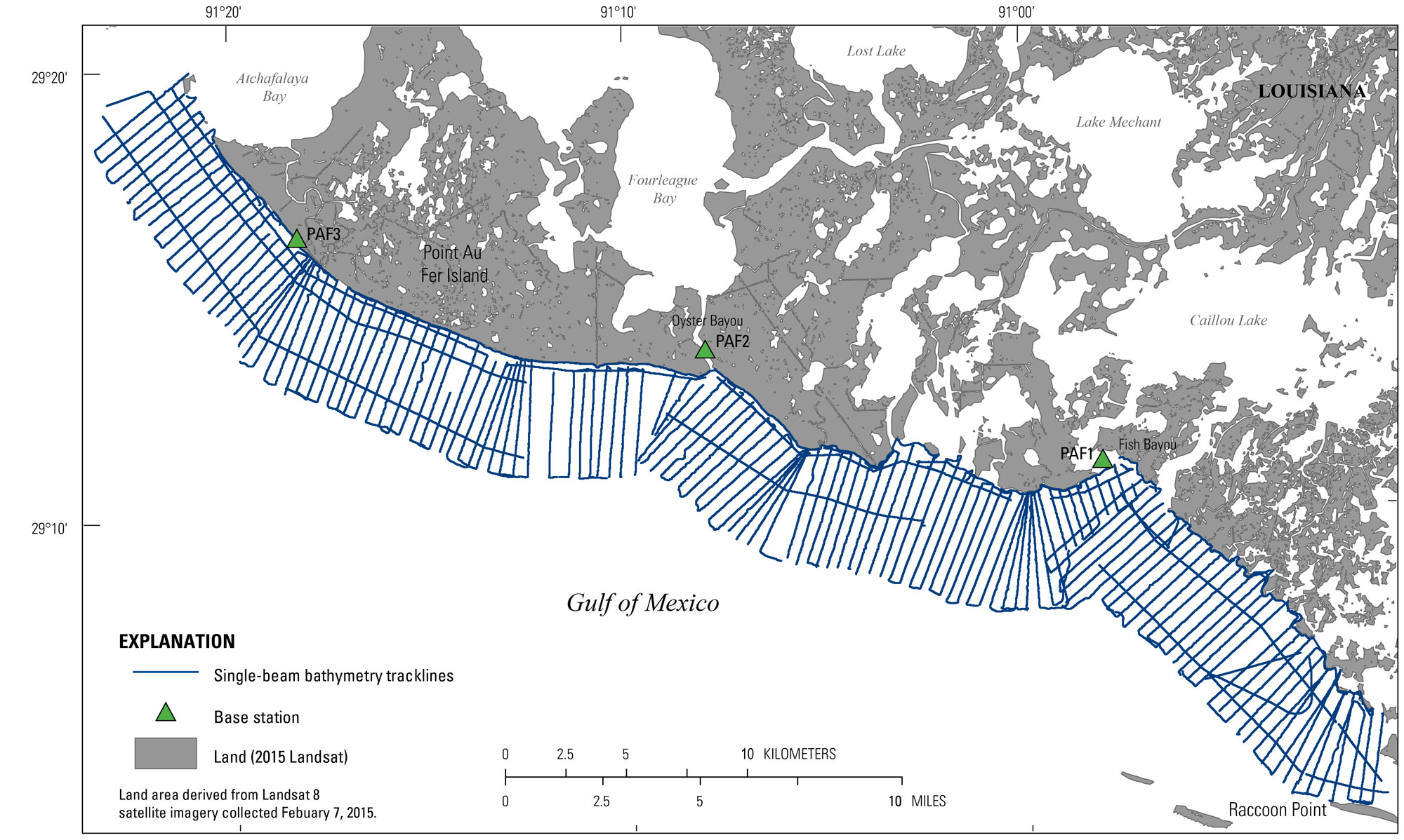
Figure 2. Trackline map overview for the 2015 Barrier Island Comprehensive Monitoring single-beam bathymetry survey along the southern coast of Louisiana, from Raccoon Point to Point Au Fer, Louisiana. [Click map to enlarge]

Data acquisition showing in A, a photograph of the R/V Sallenger vessel used for data collection and in B, a trackline map of 307.7 line-km (70 lines) single-beam bathymetry results (USGS SPCMSC cruise identifier 15BIM05).
Figure 3. Data acquisition showing in A, a photograph of the R/V Sallenger vessel used for data collection and in B, a trackline map of 307.7 line-km (70 lines) single-beam bathymetry results (USGS SPCMSC cruise identifier 15BIM05). [Click figure to enlarge]
     Data acquisition showing in A, a photograph of the R/V Jabba Jaw vessel used for data collection and in B, a trackline map of 164.4 line-km (34 lines) single-beam bathymetry results (USGS SPCMSC cruise identifier 15BIM06).
Figure 4. Data acquisition showing in A, a photograph of the R/V Jabba Jaw vessel used for data collection and in B, a trackline map of 164.4 line-km (34 lines) single-beam bathymetry results (USGS SPCMSC cruise identifier 15BIM06). [Click figure to enlarge]


Data acquisition showing in A, a photograph of the R/V Shark vessel used for data collection and in B, a trackline map of 246.7 line-km (72 lines) single-beam bathymetry results (USGS SPCMSC cruise identifier 15BIM07).
Figure 5. Data acquisition showing in A, a photograph of the R/V Shark vessel used for data collection and in B, a trackline map of 246.7 line-km (72 lines) single-beam bathymetry results (USGS SPCMSC cruise identifier 15BIM07). [Click figure to enlarge]
     Data acquisition showing in A, a photograph of the R/V Chum vessel used for data collection and in B, a trackline map of 392.2 line-km (123 lines) of single-beam bathymetry results (USGS SPCMSC cruise identifier 15BIM08).
Figure 6. Data acquisition showing in A, a photograph of the R/V Chum vessel used for data collection and in B, a trackline map of 392.2 line-km (123 lines) of single-beam bathymetry results (USGS SPCMSC cruise identifier 15BIM08). [Click figure to enlarge]


Table 1.  Summary of the USGS Field Activity Number (FAN) 2015-320-FA and their vessel cruise identifiers, listing the vessel platform, data type, total trackline count, and total trackline length surveyed.

USGS FAN 2015-320-FA
Cruise Identifier Vessel platform Data type Total tracklines Total trackline length (km)
15BIM05 R/V Sallenger SBB 70 307.7
15BIM06 R/V Jabba Jaw SBB 34 164.8
15BIM07 R/V Shark SBB 72 246.7
15BIM08 R/V Chum SBB 123 392.2
Total     299 1,111.4

Accessibility FOIA Privacy Policies and Notices

Take Pride in America logo USA.gov logo U.S. Department of the Interior | U.S. Geological Survey
URL: http://pubsdata.usgs.gov/pubs/ds/1041/ds1041_overview.html
Page Contact Information: GS Pubs Web Contact
Page Last Modified: Thursday, 09-Mar-2017 16:20:26 EST