Data Series 1078
| Data DownloadsData described in this report are available for download and consist of JPEG images of processed GPR data with elevation corrections, raw GPR trace data and post-processed differential GPS data in ASCII format, and GIS trackline files in Esri shapefile (.shp) and Keyhole Markup Language (KML) formats. All acquired data and associated formal FGDC data can be downloaded from the table below or from the associated data release (Forde and others, 2018) The ASCII GPR data can be viewed with XYZ-type packages capable of importing and imaging the data—software such as MathWorks Matlab R2017a (https://www.mathworks.com/products/matlab.html), Reflexw (http://www.sandmeier-geo.de/reflexw.html) and GNU Octave (https://www.gnu.org/software/octave/). The terrain-corrected GPR profiles (JPEG images) can be viewed using standard image viewing software. Navigation data for the GPR profiles are provided as NMEA GGA strings in ASCII format or as GIS trackline files that can be viewed using the free ArcGIS Explorer or Google Earth GIS viewers. All navigation data use the projected coordinate system North American Datum of 1983 (NAD83), Universal Transverse Mercator (UTM) Zone 18 North (18N); all elevations are North American Vertical Datum of 1988 (NAVD88) orthometric heights, derived using the GEOID12A geoid model. ArcMap DocumentA hyperlinked GPR trackline map is included with the 2016-322-FA_tracklines.zip archive. The map document was created using Esri ArcGIS 10.3 software. This archive also contains an images folder, which stores the JPEG (.jpg) images of the profile for each trackline. To access these images using ArcMap 10.3, open the map document and click on the hyperlink button (the symbol is a lightning bolt) located on the toolbar. Once this button is activated, the trackline names will all change to blue, indicating they are hyperlinks. Selecting a trackline will open the associated profile image. All metadata files are provided in text and machine-readable Extensible Markup Language (XML) formats. *Note: ArcMap 10.3 (.mxd) files are not backward compatible; however, the shapefiles can be viewed using earlier versions of ArcGIS software. 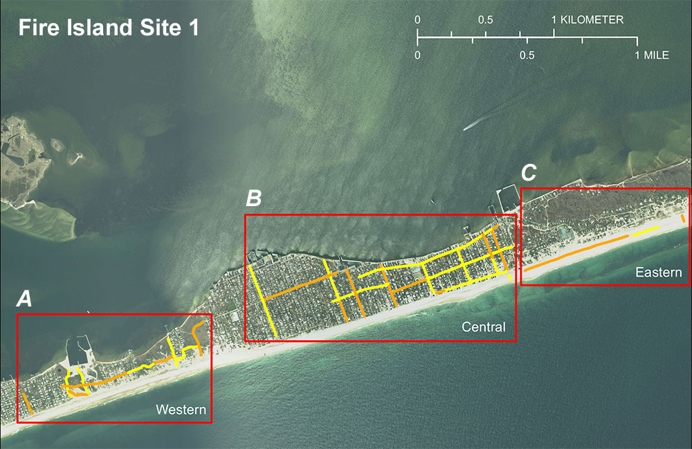 Figure 5. Locations of ground penetrating radar (GPR) profiles collected in April 2016 from Fire Island, New York, at survey site 1 with subregions (A) western, (B) central, and (C) eastern. Red boxes are enlarged in figure 6A–C below to show GPR trackline locations. Background image is a multiresolution seamless image database (MrSID) orthophotograph collected in 2015. 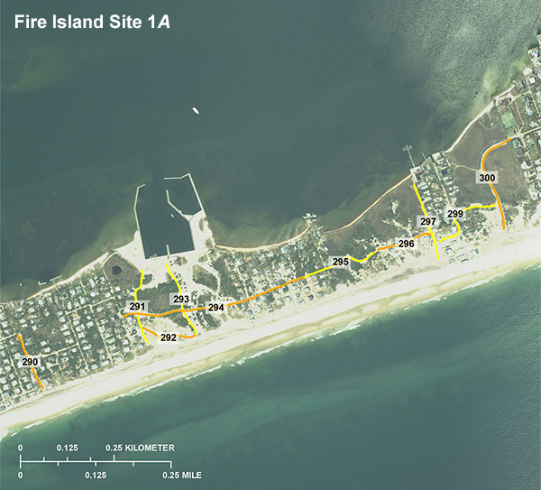 Figure 6 A. Locations of ground penetrating radar (GPR) profiles collected in April 2016 from Fire Island, New York, at survey site 1A. Click on a line number to view an image of each subsurface profile (.jpg format). 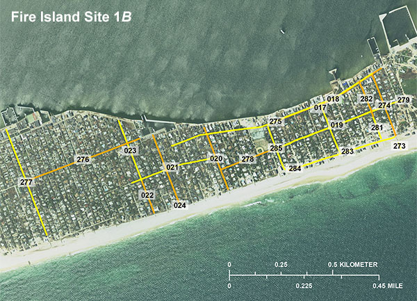 Figure 6 B. Locations of ground penetrating radar (GPR) profiles collected in April 2016 from Fire Island, New York, at survey site 1B. Click on a line number to view an image of each subsurface profile (.jpg format). 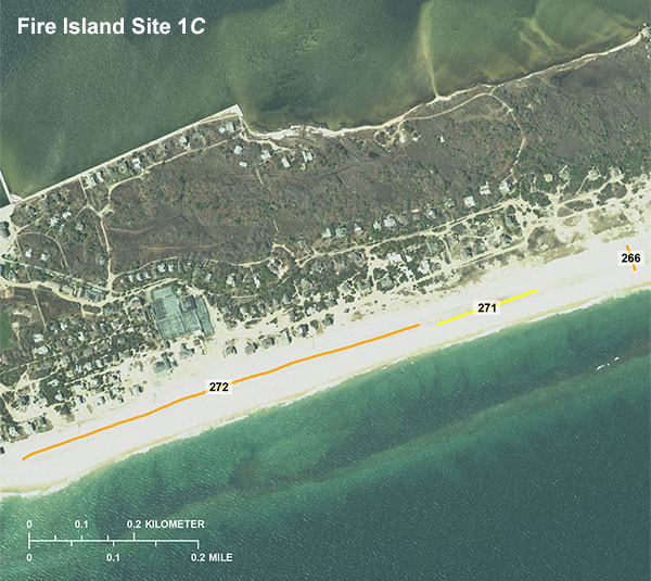 Figure 6 C. Locations of ground penetrating radar (GPR) profiles collected in April 2016 from Fire Island, New York, at survey site 1C. Click on a line number to view an image of each subsurface profile (.jpg format). 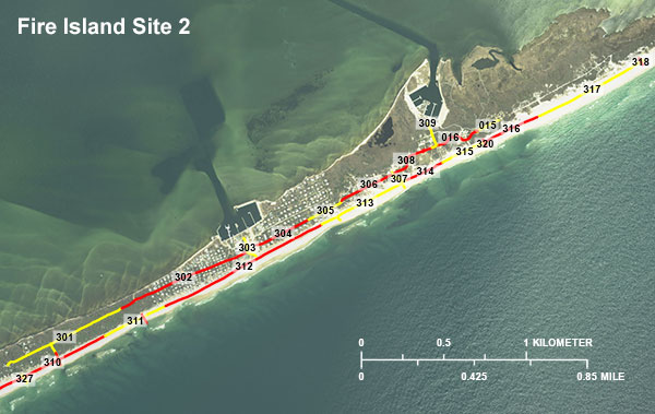 Figure 7. Locations of ground penetrating radar (GPR) profiles collected in April 2016 from Fire Island, New York, at survey site 2. Click on a line number to view an image of each subsurface profile (.jpg format). 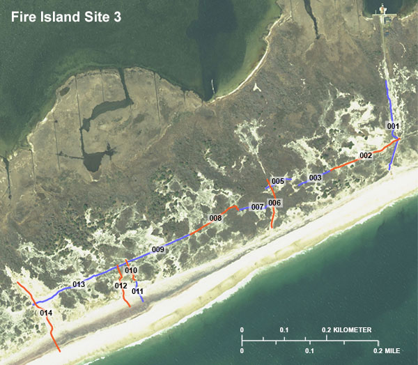 Figure 8. Locations of ground penetrating radar (GPR) profiles collected in April 2016 from Fire Island, New York, at survey site 3. Click on a line number to view an image of each subsurface profile (.jpg format). Data Download Table
| |||||||||||||||||||||||||||||||||||||||||

![]() U.S. Department of the Interior |
U.S. Geological Survey
U.S. Department of the Interior |
U.S. Geological Survey
URL: http://pubsdata.usgs.gov/pubs/ds/1078/ds1078_data-downloads.html
Page Contact Information: GS Pubs Web Contact
Page Last Modified: Wednesday, 21-Feb-2018 08:32:45 EST
