U.S. Geological Survey Data Series 74, Version 3.0
Long-Term Oceanographic Observations in Massachusetts Bay, 1989-2006
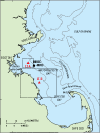
This data report presents long-term oceanographic observations made in western Massachusetts Bay at long-term site A (LT-A) (42° 22.6' N., 70° 47.0' W.; nominal water depth 32 m) from December 1989 through February 2006 and long-term site B (LT-B) (42° 9.8' N., 70° 38.4' W.; nominal water depth 22 m) from October 1997 through February 2004 (fig. 1). The observations include time-series measurements of current, temperature, salinity, light transmission, pressure, oxygen, fluorescence, and sediment-trapping rate. About 160 separate mooring or tripod deployments were made on about 90 research cruises to collect these long-term observations. This report presents a description of the 16-year field program and the instrumentation used to make the measurements, an overview of the data set, more than 2,500 pages of statistics and plots that summarize the data, and the digital data in Network Common Data Form (NetCDF) format. This report includes all data collected from December 1989 through February 2006, and updates and replaces Butman and others (2004), which presented the data collected from December 1989 through December 2002. The long-term oceanographic observations were collected by the U.S. Geological Survey (USGS) in cooperation with the Massachusetts Water Resources Authority (MWRA) and with logistical support from the U.S. Coast Guard (USCG). The long-term oceanographic observations were designed to understand the transport and long-term fate of sediments and associated contaminants in Massachusetts Bay (Bothner and Butman, 2007). LT-A is located approximately 1 km south of the new ocean outfall that began discharging treated sewage effluent from the Boston metropolitan area into Massachusetts Bay on September 6, 2000. LT-B is located about 28 km southeast of the new outfall in the direction of the mean current in Massachusetts Bay (fig. 2). The observations document sediment resuspension and transport, and seasonal and inter-annual changes in currents, hydrography, and suspended-matter concentration. They also provide observations for testing numerical models of circulation and transport. Butman and others (2007) present an overview of the tidal, low-frequency, and mean currents in Massachusetts Bay and the seasonal variations in surface waves, temperature, salinity, and wind stress based on the long-term oceanographic observations at LT-A and LT-B; other field observations; and model simulations of the current in Massachusetts Bay. Warner and others (2008) describe currents and sediment transport driven by northeast winter storms, and Butman and others (2008c) rank winter storms in Massachusetts Bay during 1990-2006 based on surface wind stress and wave bottom stress. Butman and others (2006) describe currents in Massachusetts Bay caused by internal waves, which may affect the currents at LT-A in summer.
|