U.S. Geological Survey Data Series 74, Version 3.0
Long-Term Oceanographic Observations in Massachusetts Bay, 1989-2006
|
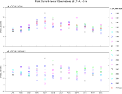
Monthly and yearly statistics (mean, standard deviation, minimum, and maximum) were calculated for meteorological, streamflow, and oceanographic variables (see tables and plots below). For the monthly statistics, the number of data points is equal to the number of hours of data recorded in each month; if the number of data points is not equal to 672, 696, 720, or 744 hours for months with 28, 29, 30, or 31 days, respectively, then the data are not complete for that month due to gaps caused by instrument retrieval and deployment, biological fouling, or instrument malfunctions. The yearly averages include all data available for the calendar year, but may not include complete coverage for the year. The statistics were calculated using the data files identified for the concatenated data series. In some cases, overlap exists between these data records chosen for concatenation, primarily because a new instrument was deployed prior to the recovery of the previous one at that depth. In these instances, the end of the earlier data record has been truncated for the statistical calculations. For scalar measurements (temperature, significant wave height, current speed, wind speed, salinity, sediment-trapping rate, and streamflow), the table includes the number of observations for a given month; the mean for that month; the anomaly, calculated as the difference between the monthly mean and the mean for the same month of all available data from 1990 to 2006; the standard deviation of the hour-averaged data (SD-H); the standard deviation of the low-pass-filtered data (SD-L); the minimum; and the maximum. The plot shows (A) the monthly mean and (B) anomaly values. The date the time-series sediment trap bottle closed is used to determine the month for the monthly statistics. The salinity observations at 30 m at LT-A prior to 1996 may be biased due to fouling of the conductivity cell (see Biological Fouling). The monthly statistics are calculated for all observations; however, the "All Years" statistics do not include the data collected prior to 1996. The scalar-measurements plot shows the monthly-averaged (A) scalar amplitude and (B) anomaly For vector measurements (wind speed, wind stress, and current), statistics were calculated for the eastward and northward components and for the scalar magnitude. For currents, statistics were calculated for the point current-meter observations and from ADCP observations at selected depths. The vector mean speed and vector mean direction were calculated from the monthly averaged east and north components. Direction is measured clockwise from north. The monthly vector mean speed and direction for all years was calculated from the monthly averaged east and north components for all years. The vector-measurements plot shows the speed of the monthly (A) vector-averaged current and (B) the associated vector direction. Tables and plots of monthly statistics of scalar and vector variables
|
|||||||||||||||||||||||||||||||||||||||||||||||||||||||||||||||||||||||||||||||||||||||||||||||||||||||||||||||||||||||||||||||||||||||||||||||||||||||||||||||||||||||||||||||||||||||||||||||||||||||||||||||