| |  | | | | | | Regional Depressurization |  |
| | | | | | | | |
|  |
| | |
| | Regional Depressurization When large volumes of oil, gas, and associated formation water are extracted from the subsurface, the natural pressures in the reservoirs are reduced (fig. 4) and stresses around the reservoir increase (fig. 1). The increased stresses cause reservoir compaction, which, in places, leads to surface subsidence. Nearly 20 billion barrels of oil and more than 150 trillion cubic feet (4.2 trillion cubic meters) of gas have been produced from coastal Texas and Louisiana since the 1920's. Although the fluid production is concentrated within the field areas, the effect of the pressure decline extends far beyond the individual fields. Where multiple fields are producing from the same strata, regional depressurization can cause subsidence and wetland losses in the areas between the fields (Kreitler and others, 1988). Consequently, induced subsidence can be either near the fields (fig. 2) or away from the fields. 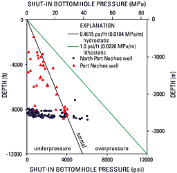 | Figure 4. Subsurface pressures measured in gas wells in the Port Neches Field and North Port Neches Field, Tex. (unpub. data from Fred Wang, University of Texas at Austin, Bureau of Economic Geology, 2001). Low subsurface pressures like those graphed can lead to increased overburden stress, compaction of the strata, reactivation of faults, and land-surface subsidence. Depths are in feet and meters; pressures are in pounds per square inch and megapascals. [larger image] | « Subsidence & Hydrocarbon Production | Faults & Releveling Surveys » |