|
A Workshop sponsored by
the
U.S. Geological Survey
at the
Colegio de Ingenieros y Agrimensores, San Juan, Puerto
Rico, March 23-24, 1999
 |
| |
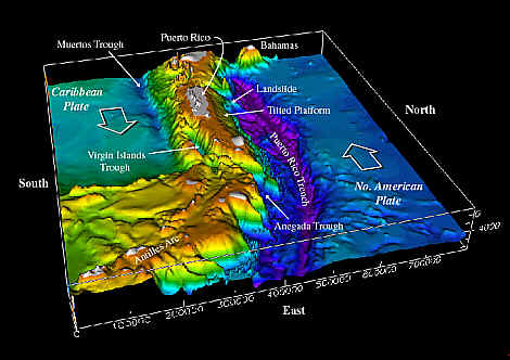
Figure 1. Morphology of the northeastern
Caribbean region, viewed from the east. The plate boundary zone
between the North American and Caribbean plates is delimited by
the Puerto Rico trench to the north of the islands and the
Anegada Trough and Muertos Trough to the south. Color shaded
bathymetry prepared by USGS. Digital data courtesy of Troy
Holcombe and Lisa Taylor, National Geophysical Data Center,
Boulder CO, from International Bathymetric Chart of the Caribbean
Sea and the Gulf of Mexico, sheet 1-09, published by Instituto
Nacional de Estadística, Geografía e
Informática, México, 1992.
|
|
U.S. Geological Survey Open-file Report 99-353 |
|
Convenors and Editors
|
|
Uri ten Brink
William
Dillon
U.S. Geological Survey
Coastal and Marine Geology Program
Woods Hole, MA 02543 |
Arthur Frankel
Charles
Mueller
U.S. Geological Survey
Earthquake Hazard Program
P.O. Box 25046, MS 966
Lakewood, CO 80225 |
Rafael W. Rodriguez
U.S. Geological Survey
Water Resources Division
Puerto Rico District Office
GSA Center
651 Federal Drive, Suite 400-15
Guaynabo, PR 00965 |
--DISCLAIMER--
This report is preliminary and has not been reviewed for
conformity
with U.S. Geological Survey editorial standards or with the North
American Stratigraphic Code. The use of trade, product, or
industry names in this report is
for descriptive or location purposes only and does not constitute
endorsement
of products by the U.S. Government. Opinions and conclusions
expressed herein do not necessarily
represent those of the USGS.
[an error occurred while processing this directive]
|
| |