The Puerto Rico region is an area of high
regional seismicity and large earthquakes. Examples include the
1918 magnitude 7.5 earthquake in Mona Passage, a magnitude 7.5
earthquake centered northeast of Puerto Rico in 1943, and
magnitude 8.1 and 6.9 earthquakes north of the Dominican Republic
in 1946 and 1953, respectively. Other large earthquakes have also
struck the area, such as in 1787 (Ms ~8.1) possibly in the Puerto
Rico trench and in 1867 (Ms ~7.5) in the Anegada Passage between
Puerto Rico and the Virgin Islands. A draft USGS hazard map
places equal probability for damaging ground motions for the city
of Mayaguez in western Puerto Rico as for Seattle. Other cities
in Puerto Rico and the Virgin Islands also have substantial
seismic risk. Because of great population density and extensive
construction near the coast, a significant earthquake/tsunami
risk exists in Puerto Rico.
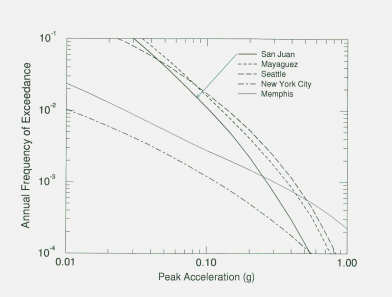 |
Figure 2. Probability for
damaging ground motion for San Juan and
Puerto Rico in
comparison to other high seismic risk areas in the
U.S.
such as Seattle. (Source: A. Frankel,
USGS) |
Eighty-eight tsunamis have been reported for the entire
Caribbean Region in the past 500 years, including 14 tsunamis
reported from Puerto Rico and the Virgin Islands (Lander et al.,
submitted). 30 tsunamis caused significant damage including
reports of as many as 9600 fatalities, which can be attributed to
tsunamigenic earthquakes and tsunamis combined. 1922 deaths are
confirmed as being specifically related to tsunamis during the
last 150 years. A 1918 M 7.5 earthquake resulted in a tsunami
that killed at least 116 people in northwestern Puerto Rico.
A runup of about 6 m has been documented by mapping, and
sedimentary evidence for at least two earlier tsunamis in the
area has been cited. Eyewitness reports of the St. Croix tsunami
give a maximum wave height of 7.6 m in Frederiksted. Immediately
after the 1946 Hispaniola earthquake a tsunami struck
northeastern Hispaniola, followed by a series of smaller
tsunamis, probably caused by continuing landsliding. The initial
tsunami was as much as 4-5 m high and propagated inland for
several kilometers, drowning, according to some reports, nearly
1,800 people.
A seismic network was established in Puerto Rico in 1979 and
was operated by the Lamont-Doherty Earth Observatory of Columbia
University for the first 5 years. The network has since been
operated and by the University of Puerto Rico, Mayaguez. A sparse
strong motion instrument network has operated in Puerto Rico
upgraded by the University of Puerto Rico, Mayaguez since the
1970s. Starting in 1995, the network has been modernized and
densified to include many more sites, both rural and within large
buildings in urban areas.
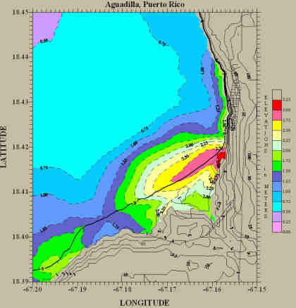 |
Figure 3. Numerical simulation of the 1918 Puerto Rico Tsunami
showing
calculated inundation of the Agmadilla coast, NW
Puerto Rico due to an
earthquake-generated Tsunami from
Mona Passage to the Northwest.
heavy
black line = coast line
thin lines = topographic
contours
(Source: E. Mercado, U. Puerto
Rico) |
The only published earthquake hazard map for Puerto Rico is by
W. McCann (1994). This map considers different source areas, such
as the Puerto Rico trench, the Mona Passage, the Muertos Trough,
and the Anegada Passage. It does not calculate the risk of
rupture of specific faults, because of lack of knowledge.
Preliminary hazard maps were presented during the workshop by the
USGS, Dames and Moore Consultants, and Risk Management Solutions,
Inc. These maps follow the assumptions stated in McCann
(1994).
Global Positioning System (GPS) geodesy is an essential
technique to constrain complex strain within the Caribbean-North
American plate boundary zone. GPS studies in the eastern Greater
Antilles and Virgin Islands have been ongoing since 1986 and
results obtained in 1994 (CANAPE project) yielded velocities for
six sites separated by ~800 km in east-west extent within the
boundary. Dixon et al. (1998) used these preliminary GPS-derived
velocities in concert with geological interpretation and simple
elastic half-space models to conclude the following:
- The relative motion of the Caribbean plate with respect to
the North American plate is essentially east at ~2 cm/yr, a rate
twice as high as predicted by the NUVEL-1A global plate motion
model (DeMets et al., 1990).
- The majority of motion east of Cabo Rojo, located in the
southernmost Dominican Republic, must be accommodated to the
north of Puerto Rico, since the measured velocity at Isabela in
Puerto Rico was similar to that at Cabo Rojo at the 95%
confidence level.
- Relative motion between North America and the Caribbean plate
is localized along one offshore fault north of the Dominican
Republic and at least two discrete onshore faults in the
Dominican Republic.
Since 1994, the regional network has been steadily improved
with the addition of several continuous GPS sites, CR01 in St.
Croix (10/95), GEOL in Mayaguez, Puerto Rico (9/96), PUR3 in
Aguadilla, Puerto Rico (6/97), and over 30 campaign sites
installed in the Dominican Republic in 1994 and 1998 and 12
campaign sites installed in Puerto Rico and adjacent islands. In
addition, reoccupation in 1998 of San Andres Island and Aves
Island in the western and eastern Caribbean plate interior,
respectively, permitted development of a well constrained
Caribbean plate velocity (Jansma et al., 1999). The current
density of sites within the boundary zone should allow us to
address: 1) the existence of a single, rigid block consisting of
Puerto Rico and the Virgin Islands; 2) the relative motion
between the eastern Dominican Republic and western Puerto Rico
and concomitant opening rate of the Mona Canyon; 3) possible
elastic strain accumulation along mapped structures in the
Dominican Republic and identification of other currently
unrecognized zones, where displacement is being accommodated; and
4) offshore displacement to the north and south of western Puerto
Rico.
Results to date have produced a well constrained regional
velocity fields referenced to either stable North America or the
Caribbean plates. Additional sites and longer time series on
existing sites, however, are required to constrain velocities
along potentially seismogenic structures both offshore and
onshore. Unpublished GPS data and analysis do allow certain broad
conclusions to be made without the benefit of the recently
densified Dominican Republic and Puerto Rico networks. Major
conclusions directly relevant to seismic hazard assessment
are:
- The majority of the slip between North America/Caribbean
plate is taken up offshore of northern Puerto Rico, but some also
is accommodated to the south, probably along the Muertos
Trough.
- Relative motion of Puerto Rico/Virgin Islands relative to
North America is northeast (more northerly than that between
North America /Caribbean plate), yielding a component of
convergence across the Puerto Rico Trench (PRT), i.e. PRT is
transpressional.
- Tectonic setting of the Anegada Passage/Whiting Basin/Virgin
Islands Basin is left-lateral transtension.
- Mona Canyon is characterized by left-oblique opening with
east-west extension.
- GPS velocities from campaign sites in western and eastern
Puerto Rico agree within 1 sigma (~1 mm/yr), implying that Puerto
Rico is rigid; data from the CGPS site at GEOL show a small
residual in the longitudinal velocity component at the 95%
confidence level, the origin of which is yet to be determined.
NASA and the Department of Defense have recently funded laser
altimetry and IFSAR surveys by the University of Puerto Rico to
generate improved digital elevation models for the eastern
Greater Antilles (Dominican Republic, Puerto Rico, Virgin
Islands) for a variety of applications, including morphotectonic
analysis and fault identification. Laser altimetry data from an
airborne Lidar instrument were collected in February 1997.
Several marine geophysical surveys have been conducted around
Puerto Rico and the Virgin Islands during the last 30 years. A
Gloria side-scan survey with coincident single-channel seismic
recording mapped giant submarine slides north of Puerto Rico. An
extensive multibeam and single-channel seismic survey by the R/V
Ewing in 1996 (van Gestel et al., 1998) mapped the deep water
north of Puerto Rico. A striking finding from this survey was a
continuous fault at the base of the north slope of the Puerto
Rico margin.
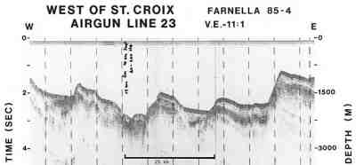 |
Figure 4.
Seismic reflection profile showing block faulting near
St Croix, USVI, collected by the USGS during GLORIA sidescan
survey of the U.S. Exclusive Economic
Zone. (Source: K. Scanlon, USGS)
|
Additional high-resolution surveys were carried out on the
shelf with Uniboom (USGS Shelf-map Series), Mini-sparker (Virgin
Island Sand Study) and an airgun (Piggyback on a DMA gravity
survey by the R/V Powell). None of these surveys were aimed at
detecting offshore faults, nevertheless, many offshore faults
were evident in the data.
Deep seismic data in the northeastern Caribbean are sparse. A
few short refraction lines using old recording and analysis
technology were collected in the Puerto Rico Trench in 1959
(Bunce and Fahlquist, 1962). Multichannel seismic reflection data
were collected both by academia and by industry in the 1970s.
Deep reflections were not observed on these data because of the
short receiver array (2400 m) and the small volume of the airguns
(<2000 cu. in.) used at the time.
References:
Bunce, E.T., and Fahlquist, D.A., Geophysical investigations
of the Puerto Rico Trench and Outer Ridge, J. Geophysical
Research, v. 67, p. 3955, 1962.
DeMets, C., R. Gordon, D. Argus, and S. Stein, Current plate
motions, Geophys. Jour. Int., v. 101, p. 425-478, 1990.
Dixon, T. H., F. Farina, C. DeMets, P. Jansma, P. Mann, and E.
Calais, Relative motion between the Caribbean and North American
plates and related boundary zone deformation from a decade of GPS
observations, Jour. Geophys. Res., v. 103, p. 15,157-15,182,
1998.
Jansma, P., R. Bilham, C. DeMets, and G. Mattioli, GPS
geodetic constraints on rigid Caribbean plate motion and plate
boundary deformation, IUGG Proc., Birmingham, England, 1999.
Lander, J.F., Whiteside, L.S., and O'Loughlin, K.F., Caribbean
Tsunamis: A 500-year history, 1498 to 1998, Natural Hazards
Journal, submitted.
McCann, W. R., Seismic hazard map for Puerto Rico, 1994,
prepared for Seismic Safety Commission of Puerto Rico, Earth
Scientific Consultants, 60 pages, 1994.
Van Gestel, J-P., Mann, P., Dolan, J.F., and Grindlay, N.R.,
Structure and tectonics of the upper Cenozoic Puerto Rico-Virgin
Islands carbonate platform as determined from seismic reflection
studies, J. Geophysical Research, v. 103, p. 30,505, 1998.
