Leaders: N. Driscoll (WHOI), K. Scanlon (USGS-CMG)
Members:
N. Grindlay (UNC-Wilmington), P. Mann (UT-Austin), E. Uchupi (WHOI), W. McCann (ESR consultants), T. Pratt (USGS - EHZ), W. Dillon (USGS - CMG), U. ten Brink (USGS – CMG), J. Pindell (Oxford U., U.K.)
Our long-term objective is to understand the complex interplay between the Puerto Rico Block and the North American and Caribbean plates in order to develop a consistent tectonic model for the geologic development and tectonic evolution of the Puerto Rico Region. Specifically, we will employ a three-pronged approach to define the fault and subduction kinematics operative across the region. We envision that these activities will proceed concomitantly and that the initiatives will be designed to complement and build on the efforts of the other research groups examining the region.
The recommended activities are:
• Analysis of relevant data and the formation of a GIS data bank for the Puerto Rico region will facilitate comparison of disparate data types and focus/prioritize future research efforts.
• Acquisition of high resolution swath (bathymetry and backscatter), topographic, and seismic reflection data to define fault systems and provide accurate surveys of shallow-water regions.
• Acquisition of deep penetration multichannel seismic reflection and OBS/OBH refraction data to constrain the deep structure and interaction between the subducting Caribbean and North American plates.
Figure 5.
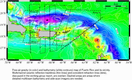
The above map shows the desired coverage of the proposed surveys.
Expected Results:
- High-resolution swath and subbottom data will characterize the fault systems and in so doing will place constraints on how faults link, their slip history and length. These constraints are needed to improve hazard models and will yield new insights because we will be able to define the fault systems rather than the present practice of using source zones for hazard predictions. By using source zones, hazard maps tend to "smear" or average hazards. Precise locations of fault systems and their direction and rate of slip will greatly improve our assessment capability.
- High resolution bathymetric maps as well as onshore data will allow the construction of more accurate tsunami runup and inundation models and, given the seismic source areas, will target regions along the coastline where future threats from tsunamis are greatest.
- High-resolution seismic data will identify faults offshore that can be correlated onshore. Onshore fault systems are often difficult to identify and onshore/offshore studies will improve our ability to resolve the three-dimensional structure of fault systems as well as reconstruct their deformational history.
- Unraveling the regional/deep structure of the Puerto Rico block is critical to understanding the surficial manifestation of the deformation; linking the deep and shallow structure represents a nested survey approach that will examine the study region across a variety of scales.
- Deep seismic reflection and velocities interpreted from OBS data will allow us to test between the two end-member models for the Puerto Rico Block. The flexurally deformed model predicts strong coupling between the Puerto Rico block and the Caribbean and North American plates. If correct, this model predicts that large earthquakes should occur both in the Puerto Rico Trench and the Muertos Trough. Conversely, the extensional model for the Puerto Rico block predicts smaller magnitude earthquakes because there is less coupling between the downgoing plates and the Puerto Rico block.
- Improved velocity constraints both offshore and onshore derived from large offset seismic experiments will improve our ability to locate earthquake epicenters and to delineate active faults from microseismicity. Because the present local network is limited to the islands, the resolution of the epicenters deteriorates considerably with distance from the island.
- Passive recording of earthquakes offshore will be used to place some boundary conditions for seismic attenuation, which are critical inputs for earthquake hazard assessments.
- High-resolution swath and subbottom data will help identify areas which are on the verge of collapse and sliding. As the analysis of the recent devastating tsunami in Papua, New Guinea shows, modest earthquakes can trigger large tsunamis by triggering offshore rock slides.
Specific concerns:
- The presence of activity on the South Puerto Rico Slope Fault Zone (SPRSFZ), the direction of motion and cumulative slip of the fault. This fault zone is located at the base of the northern slope of Puerto Rico, and was recently mapped by Grindlay and Mann using low resolution swath bathymetry and side-scan images. It may be an alternative source to the 1787 (Ms ~ 8.1) earthquake, which typically is attributed to interplate motion at the trench.
- A multitude of small faults are currently drawn across and along the Mona Passage, and at least three young "rifts" are identified. The plate boundary motion in the Dominican Republic is well defined along several major faults, such as the Septentrional and the Plantain Gardens faults. However, these faults cannot be extended across the Mona Passage although the overall block motion from GPS requires their continuation. The challenge will be to identify the main active faults within the Mona Passage area.
- The Muertos Trough appears from the world-wide catalog of earthquakes to be an active zone of convergence south of the Dominican Republic and probably southwest of Puerto Rico. However, it is unclear how far east along the south coast of Puerto Rico the present activity extends.
- The character of the North American plate-Puerto Rico block boundary at the trench. Current hazard assessment maps (e.g., McCann, 1994) assume a 200 km long and 50-70 km wide fault zone between them which ruptures in a thrust motion. Available multichannel seismic data, suggest however, that the boundary between the plate and the block may be complex and internally deformed. The dip of this boundary is also unknown. Deep seismic reflection and refraction survey will be aimed at solving this puzzle.
