Surficial Geology and Distribution of Post-Impoundment Sediment of the Western Part of Lake Mead Based on a Sidescan Sonar and High-Resolution Seismic-Reflection Survey
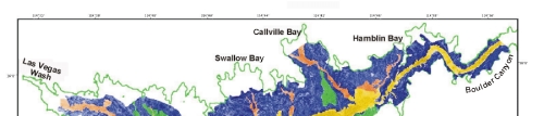
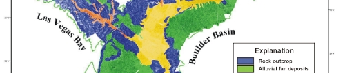
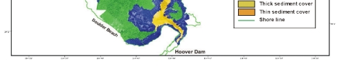
Figure 5. Interpretation of the sidescan sonar image from the Boulder Basin and Las Vegas Bay parts of Lake Mead. The lake floor is divided into four general provinces. Alluvial: unconsolidated sand and gravel that was deposited primarily as alluvial fans prior to the formation of the lake. Rock: areas of exposed rock outcrop, and, like alluvial deposits, indicates areas of the lake floor that have not been covered by sediment (or only have a minimal sediment cover) since the lake formed. Thick sediment: sediment that has accumulated since impoundment that is more than 2-m thick. Thin sediment: sediment that has accumulated since impoundment that is less than 2-m thick, and often is too thin to be resolved by the seismic system used to map sediment thickness (ie. less than 0.5 m thick).
|