Open-File Report 01-179
| GIS Description Abstract Introduction Revisions and Updates File and Data Formats File Organization GIS Data Layers: BASEMAPS BATTOPO SHADEREL NAVIGATN BACKSCAT SAMPLES GEOLOGY Related Data Acknowledgments References Data Catalog Revision History Directory Listing |
GIS Data Layers (continued)SAMPLES
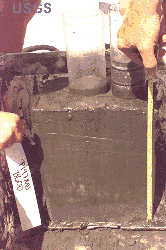
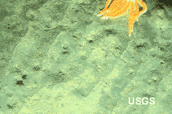
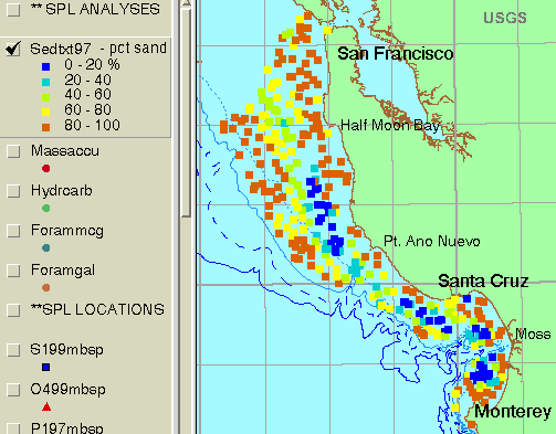
More than 400 sediment samples were collected in MBNMS using a box corer and other sampling devices between San Francisco and Monterey. The box core provides relatively undisturbed samples of seafloor sediment for analysis. A camera attached to the box corer provides images of the seafloor just before the sampler is triggered. Photographic images of the sea floor and physical samples are used to identify the lithologies that are interpreted on the map of the sea floor (Orzech and others, 2001). Matching the locations of lithologies identified in photographs to the sidescan mosaic provides a key to the type of rocks that particular sonar backscatter intensities are recording. The sediment sample data layers in the GIS consist of locations with a related database table for each of the different analyses conducted on the samples, e.g., grain size, organic carbon content, sediment accumulation rates, and foraminifer abundance (Edwards and others, 2002).
Mass spectrometry provides a geochemical signature of the hydrocarbon component of the sediment containing both marine and terrigenous sources. The attributes in the hydrocarbon database table are the abundance of hydrocarbon molecules and key weight ratios (Kvenvolden and others, 2002). For example, the abundance of polycyclic aromatic hydrocarbons (PAH) exceeds 900 ng/g in the samples analyzed from the sanctuary.
Lead-210 dating techniques are used to resolve sediment and mass accumulation rates on 100-year time scales. The data table for these analyses includes sediment and mass accumulation rates and inventory. In the sanctuary study area, sediment accumulation rates are as much as 3.9 mm/y over the past 100 years. Mass accumulation rates, which are a more accurate measure of sediment accumulation because of variation in compaction, are as much as 0.42 g/sq cm/y over the past 100 years (Lewis and others, 2002).
Foraminifers are microorganisms which live in the water column (planktonic) or sediment (benthic). They are abundant and easily acquired, making them useful tools in characterizing biotas in the marine realm. Their distributions are dependent upon a number of environmental factors water temperature, salinity, nutrient and oxygen content, calcium carbonate or lithic availability, pollution, and currents. A species' presence or absence, and the size of its population, indicates different ecological conditions. The foraminifer database table is related to the sample locations layer with varieties of foraminifers as attribute items (McGann, 2002). Historic sample data sets include foraminifer data (Galliher, 1932) and locations and descriptions of dredge samples (Nagel, 1986; McCulloch, 1985). |

![]() U.S. Department of the Interior |
U.S. Geological Survey
U.S. Department of the Interior |
U.S. Geological Survey
URL: http://pubsdata.usgs.gov/pubs/of/2001/0179/2_montgis3.html
Page Contact Information: GS Pubs Web Contact
Page Last Modified: Wednesday, 07-Dec-2016 18:58:24 EST


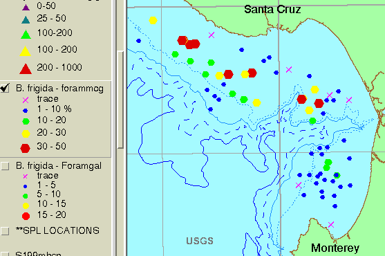
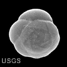 B. frigida