GIS Description Abstract
Introduction
Revisions and Updates
File and Data Formats
File Organization
GIS Data Layers:
BASEMAPS
BATTOPO
SHADEREL
NAVIGATN
BACKSCAT
SAMPLES
GEOLOGY
Related Data
Acknowledgments
References Data Catalog Revision History Directory Listing
Contacts
|
Abstract
A marine sanctuary is an environment where the interests of science and society meet. Sanctuary managers need access to the best scientific data available that describe the environment and environmental processes in sanctuaries. Seafloor mapping and sampling in the Monterey Bay National Marine Sanctuary have revealed new details about the geology, morphology, and active geologic processes of this region. Data from sidescan sonar, multibeam sonar bathymetry, physical samples, and instrument moorings, are consolidated with new and existing maps in a geographic information system (GIS). The GIS provides researchers and policymakers a view of the relationship among data sets to assist science studies and to help with economic and social policy-making decisions regarding this protected environment.
Introduction
 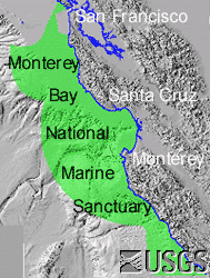
The Monterey Bay National Marine Sanctuary (MBNMS) was established in 1992 to protect and manage the resources of the 13,760 sq km (5300 sq mi) area off the coast of central California. The sanctuary's objectives are to enhance resource protection, preserve natural beauty, and preserve the bounty of marine ecosystems (MBNMS, 1999).
The U.S. Geological Survey (USGS) conducted a research project in the sanctuary from 1994 to 2000 to determine the marine geological environment (Eittreim and Noble, 2002). The focus of the USGS study is on the broad, flat continental shelf, areas shallower than 200 m (656 ft), between San Francisco to the north and Point Sur to the south. This area is approximately 3,000 sq km (1,160 sq mi) or 20 percent of the areal extent of the sanctuary. The project tasks focused on seafloor mapping, sediment sample collection and analysis, and oceanographic processes. The data resulting from this research is presented in this geographic information system (GIS) compilation. The GIS data are also viewable on the Coastal and Marine Geology internet map server at http://kai.er.usgs.gov/regional/contusa/westcoast/.
Contents
Revisions and Updates
This GIS compilation will be revised and updated as new data become available. The most flexible way to do this will be to post changes on the internet (online). Version 1.0 will be published as a CD-ROM and will also be published online at http://geopubs.wr.usgs.gov/open-file/of01-179/. All future revisions will be published only online. The hosting site could change. If there is no forwarding link, go the the USGS home page and search for of01-179.
Contents
File and Data Formats
Text files (.txt) on the CD-ROM and web site may be viewed without special software. Hypertext mark-up language files (.html) require a browser such as Netscape Navigator or Internet Explorer. GIF (.gif), JPEG (.jpg) or TIFF (.tif) images may be viewed by many common image software packages. The data files require ESRI ArcExplorer, ArcView, or ArcInfo. The data files can be accessed by these three applications directly from the CD-ROM. The source file for ArcExplorer, an application that ESRI licenses without charge for Windows operating systems, is included under the 'aexplore' directory. ArcView and ArcInfo are licensed applications that must be purchased.
The data were compiled in ArcInfo (version 8.0.2, ESRI, 1982-2000), a commercial GIS, in the UTM Zone 10 coordinate system with datum NAD83. Raster data layers are in ArcInfo GRID format or are registered TIFF images. Point, line and polygon features are in ArcInfo COVERAGE format. Shapefiles were generated for those coverages where the shape format did not degrade the data excessively. Each data layer is accompanied by FGDC-compliant metadata and an overview map.
Contents
File Organization
Top level files:
- 1_readme.txt - plain text file to introduce CD-ROM index.html - this document: start of description of GIS
- 2_montgisX.html - for X = 2-6; continuation of description of GIS which starts with index.html
- 3_catalog.html - contents of the GIS
- 4_reference.html - bibliographic references
- mont.apr - ArcView (version 3.2a) project file to view data layers. The project can be opened from the CD-ROM, but will load and redraw slowly. If there is space (500 Mb) on the local computer, copy "mont.apr" and the "data" directory to an empty directory, start ArcView, and open the project from this directory.
- mont.aep - ArcExplorer project file to view selected data layers. Only a few layers are displayed to demonstrate the software.
- version_history.txt - revision information
- sitemap.txt - directory listing
Top level directories:
aexplore - Source file and description for ArcExplorer 2.0.8 application for users of Windows NT/95/98 or higher
data - ArcInfo data coverages, grids, and images with metadata files (.txt). The files in ArcInfo format are accessible to ArcInfo or ArcView directly from the CD-ROM. The files in TIFF format are viewable in any image software.
exp_arc - ArcInfo export files; available on the web site only
html - subordinate web pages
images - .gif, .jpg: images referenced by documents in this publication
legends - .avl: ArcView legend files for selected data sets
shape - Selected shapefiles, copies of projection (.prj), and metadata (.txt) files for use with ArcView and other applications that read .shp format files. Not all coverages could be converted to shapefiles because of the file name and item name character limits. If a coverage has more than one feature (for example polygons and lines), only one feature may be provided as a shapefile.
For more information, contact
Florence L. Wong
Stephen L. Eittreim
U.S. Geological Survey
345 Middlefield Road, MS 999
Menlo Park, California 94025
Next
Contents |

