Open-File Report 01-179
| GIS Description Abstract Introduction Revisions and Updates File and Data Formats File Organization GIS Data Layers: BASEMAPS BATTOPO SHADEREL NAVIGATN BACKSCAT SAMPLES GEOLOGY Related Data Acknowledgments References Data Catalog Revision History Directory Listing |
Related USGS Monterey Bay Data SetsSeveral other GIS data sets related to the USGS Monterey Bay study, but not included in the CDROM, are described here.
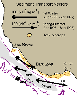
Instrument Mooring Data. Data from instrument packages that monitor currents, turbidity, sediment accumulation, hydrostatic pressure, salinity, and temperature at various depths in the water column helped determine that strong transport events primarily occur during winter storms and that suspended sediment tends to move out of Monterey Bay, subparallel to bathymetric contours (Xu and others, 2002). Click on the image above for graphs of some of the temperature and current data.
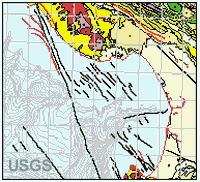
Geologic Mapping Onshore. Detailed digital onshore geologic maps (e.g., Brabb and others, 1998; Wagner and others, 1999, 2002) were used in the seafloor studies. 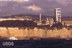 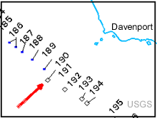 Sea Cliff Photographic Transect. An overlapping series of photographs of the rugged shoreline between Point Ano Nuevo and Santa Cruz harbor provides a baseline record of the appearance of this coast the year after the 1997-1998 El Nino event (Chezar and Wong, 2000). This data layer consists of locations (navigated by GPS) from which the photographs were taken and is linked to photographic images.
LIDAR. LIDAR (LIght Detection And Ranging) surveys of the central California coast collected high-resolution elevation data and illustrate coastal change over the 1997-1998 El Niño climatic event (USGS, 1998). These surveys complement 14 years of beach profiling in the Monterey area (Dingler and Reiss, 2002).
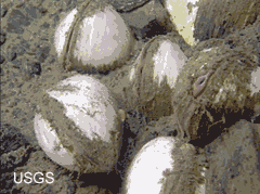
Fluid Seeps. Fluid venting in the Monterey Canyon area is an active process that hosts chemosynthetic 'cold seep' ecosystems (including clams such as those pictured) and may play an important role in world-wide, deep ocean ecology and element cycling (Lorenson and others, 2002). |

![]() U.S. Department of the Interior |
U.S. Geological Survey
U.S. Department of the Interior |
U.S. Geological Survey
URL: http://pubsdata.usgs.gov/pubs/of/2001/0179/2_montgis5.html
Page Contact Information: GS Pubs Web Contact
Page Last Modified: Wednesday, 07-Dec-2016 18:58:25 EST