Open-File Report 01-179
| GIS Description Abstract Introduction Revisions and Updates File and Data Formats File Organization GIS Data Layers: BASEMAPS BATTOPO SHADEREL NAVIGATN BACKSCAT SAMPLES GEOLOGY Related Data Acknowledgments References Data Catalog Revision History Directory Listing |
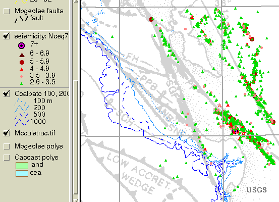
GIS Data Layers (continued)GEOLOGYThe compilation of this GIS benefited greatly from the large body of geological research that has been conducted in the central California region. A map overview of the regional tectonics was scanned and included as a TIFF image (McCulloch, 1989). Seismicity catalogues, and prevous stratigraphic studies provide a framework for the newly acquired data and results of the current study. Seismicity and Faulting
MBNMS is segmented by various faults that are part of the active San Andreas and San Gregorio-Hosgri Fault zones (McCulloch, 1989; Jayko and Lewis, 1996). The epicenter of the 1989 Loma Prieta earthquake (magnitude 7.2; Stover and Coffman, 1993) lies no more than 17 km (11 mi) inland from Monterey Bay. The 1926 Santa Cruz earthquake (magnitude 6.1; Stover and Coffman, 1993) occurred below the seafloor about 15 km (9 mi) west of Santa Cruz, probably along the San Gregorio Fault. Acoustic profiling, sidescan images, and micro- (small magnitude) seismicity help refine the locations of traces of the faults in the offshore area. Data from the seismicity catalogues (e.g., NCEDC, 1996) are included in the GIS for this type of structural analysis. Quaternary sedimentation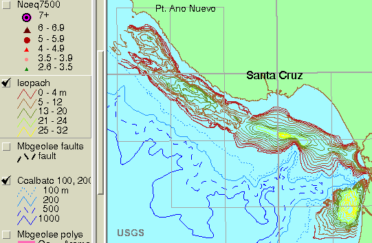
Previous stratigraphic studies (Greene, 1977; Mullins and others, 1985; Chin and others, 1988) based on seismic-reflection data describe the sedimentary structure underlying the shelf areas of MBNMS mapped in this study. As much as 33 m (110 ft) of Holocene sediment has been detected in the central mud belt on the shelf. The contour data from these studies were converted from illustrations in the reports for the GIS. Epicenter Relocations
Ross and others (1998) have relocated earthquake epicenters with the VELEST model (Kissling and others, 1995) as part of a study to determine more precisely the offshore trace of the San Gregorio Fault in the Monterey Bay area. The original and relocated epicenters with relocation vectors are included in the GIS. Seafloor Geologic Map
A lithologic map of the sea floor has been interpreted from the sidescan imagery, seismic-reflection profiles, previous work, and sample analyses (Eittreim and others, 2000). The primary lithologic units include the offshore extensions of Cretaceous and Tertiary granitic and metamorphic rocks, Tertiary and Quaternary sedimentary rocks, and Quaternary marine sediments (mud, coarse sand, relict gravel). This GIS data layer consists of polygons identified by lithologic unit. |

![]() U.S. Department of the Interior |
U.S. Geological Survey
U.S. Department of the Interior |
U.S. Geological Survey
URL: http://pubsdata.usgs.gov/pubs/of/2001/0179/2_montgis4.html
Page Contact Information: GS Pubs Web Contact
Page Last Modified: Wednesday, 07-Dec-2016 18:58:24 EST