Geologic Environment
Massachusetts Bay encompasses an area enclosed by Cape Ann to the north, a limit defined to the east by Stellwagen Bank and Race Point on Cape Cod, to the south by Cape Cod Bay, and by the Massachusetts coast to the west (Figure 1).
 |
| Figure 1. Location of the Massachusetts Bay outfall site showing its proximity to the Stellwagen Bank National Marine Sanctuary to the east and Cape Cod to the south. |
Presently, the irregular sea-floor surface of Massachusetts Bay reflects complex events of multiple glaciations, isostatic rebound, subsequent marine incursion, and modern sea-floor processes. There are two significant bathymetric features located within this inner shelf area: Stellwagen Bank located near its eastern limit and Stellwagen Basin between the bank and the coast. Preglacial fluvial erosion and glacial scour of the bedrock and coastal plain deposits produced large-scale bathymetric lows such as Stellwagen Basin and left large morphologic highs such as Stellwagen Bank (Oldale, 1993).
The inner shelf of Massachusetts Bay has been glaciated at least twice. Deposits of a pre-Wisconsinan drift (Illinoian?), known as the lower or drumlin till, consists primarily of cobbles and boulders. A younger drift was deposited in the late-Wisconsinan time during the retreat of the marine-based Laurentide ice sheet. It consisted of a mixture of coarse ice-contact and outwash deposits of submarine origin and fine-grained glacial marine deposits (Oldale and Bick, 1987). After the ice retreated, glacial unloading of the depressed crust caused the shoreline to regress across the present inner shelf area. This regression produced a sea-level low stand at about 12,000 years BP of approximately -43 m compared to that of present day sea level (Oldale and others, 1993). This lowstand was followed by the Holocene marine incursion of the sea (in response to a eustatic rise of sea level), which truncated and eroded the glacial deposits. The incursion formed a transgressive unconformity atop this surface that in many places extends to the present day shoreline. Modern beach and bar deposits have formed on this surface both offshore and along the coast and have been subjected to a wave and current regime similar to that at present (Knebel and others, 1991).
Sediment sampling, benthic biology, and sea-floor mapping studies have provided much of the current knowledge on the types and spatial variability of the surficial sedimentary environments distributed in Massachusetts Bay (Schlee and others, 1973; Meisburger, 1976; SAIC, 1987; Oldale and Bick, 1987; Shea and others, 1991; Bothner and others, 1992; Hilbig and others, 1997). A synthesis of various sidescan-sonar surveys of Boston Harbor and the inner shelf of Massachusetts Bay (from the coastline out to the 50 m isobath) identified three categories of sedimentary environments. Within the confines of the study area, environments of erosion and nondeposition occupied slightly more than 70% of this area whereas areas of sediment reworking and deposition occupy 26% and 3%, (Knebel and Circe, 1995).
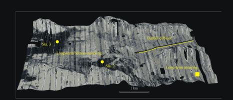
|
| Figure 2. A sidescan sonar map (looking northward) depicting the bathymetry and locations of the two USGS long-term monitoring sites (stations #2 and #3) and their proximity to the outfall diffuser pipe. |
Bathymetric highs are probably remnants of glacially-derived drumlins or ice-contact
deposits. They contain coarse-grained sediments ranging from boulders and cobbles to well-sorted sands. These areas are characterized by high reflectivity and appear as lighter tones in the
sidescan-sonar records (Figure 2).
The depressions along the sea floor are localized topographic lows that contain finer grained sediments such as fine sands, silts, and clays. These areas tend to absorb sound more readily and appear as darker shaded areas on the records representing the ocean bottom.
USGS sampling stations #2 and #3 (water depths 33 and 35 m, respectively) are classified
as depositional based on the sidescan-sonar survey (Figure 2 and Bothner and others 1992).
Bottom sampling and textural analyses indicated that sediment at station #2 is fine sand and at
station #3 is mud.
[an error occurred while processing this directive]