OF 02-152 Home
DVD-ROM
Contents
Geologic
Discussion
GIS Data
Contacts
|
Introduction
Click on each figure below to view larger image. Click on figure number to go to figure-caption page for links to images in PDF format and for further explanation of the images.
A principal focus for the U.S. Geological
Survey (USGS) Coastal and Marine Geology Program (marine.usgs.gov) is regional reconnaissance mapping of inner-continental shelf areas,
with initial emphasis on heavily used areas of the sea floor near
major population centers. The objectives are to develop a detailed
regional synthesis of the sea-floor geology in order to
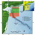 |
| Figure
1. Map showing location of study area, ship tracklines & major physiographic & geographic features. Click on figure for large image.
|
provide information for a wide range of management decisions and to
form a basis for further investigations of marine geological processes.
In 1995, the USGS, in cooperation with the U.S. Army
Corps of Engineers (USACOE), New York District, began
to generate reconnaissance maps of the continental shelf seaward of
the New York - New Jersey metropolitan area. This mapping encompassed
the New York Bight inner-continental shelf, one of the most heavily
trafficked and exploited coastal regions in the United States (Fig.
1). Contiguous areas of the Hudson Shelf Valley, the largest physiographic
feature on this segment of the continental shelf (Fig.
1), also were mapped as part of a USGS study of contaminated sediments
(Buchholtz ten Brink and others, 1994; 1996).
The goal of the reconnaissance mapping was to provide a regional
synthesis of the sea-floor geology in the New York Bight area, including:
(a) a description of sea-floor morphology; (b) a map of sea-floor
sedimentary lithotypes; (c) the geometry and structure of the Cretaceous
strata and Quaternary deposits; and (d) the geologic history of the
region. Pursuing the course of this mapping effort, we obtained sidescan-sonar
images of 100 % of the sea floor in the study area(Fig.
2a). Initial interpretations of these sidescan data were presented
by Schwab and others,
 |
| Figure
2a. Map showing sidescan-sonar imagery of area with overlays showing sediment sample locations, bathymetry, dumpsite locations. Click on figure for larger image.
|
(1997a, 1997b, 2000a). High-resolution seismic-reflection profiles collected along
each sidescan-sonar line used multiple acoustic sources (e.g., watergun,
CHIRP, Geopulse). Multibeam swath-bathymetry data also were obtained
for a portion of the study area (Butman and others, 1998;) (Fig.
1). In this report, we present a series of structural and sediment
isopach maps and interpretations of the Quaternary evolution of the
inner-continental shelf off the New York - New Jersey metropolitan
area based on subbottom, sidescan-sonar, and multibeam-bathymetric
data.
To view files in PDF format, download free copy of Adobe Acrobat Reader www.adobe.com/products/acrobat/alternate.html.
|