OF 02-152 Home
DVD-ROM
Contents
Geologic
Discussion
GIS Data
Contacts
|
Discussion
The high-resolution geophysical
data collected in the New York Bight provides a means to assess
the evolution of the shelf during the Quaternary, but interpretations
of these data are limited by a lack of cores or borehole information.
Quaternary sea-level oscillations are thought to have resulted in
a series of unconformities and diastems underlying the New York
Bight (Dillon and Oldale, 1978; Shackleton, 1987, 1988). However,
deposition of the Quaternary sedimentary deposit was principally
controlled by the geometry of the coastal-plain unconformity which
truncates Late Cretaceous to early Tertiary coastal-plain strata.
The geometry of the coastal-plain Unconformity limited the accommodation
space available for subsequent deposition of Quaternary sediment.
Outcrops of coastal-plain strata formed resistant bathymetric highs
and, in places, must have acted as the core of subaerial headlands
during Pleistocene marine transgressions/regressions, precluding
deposition of fluvial or marine sediment. Resistant topographic
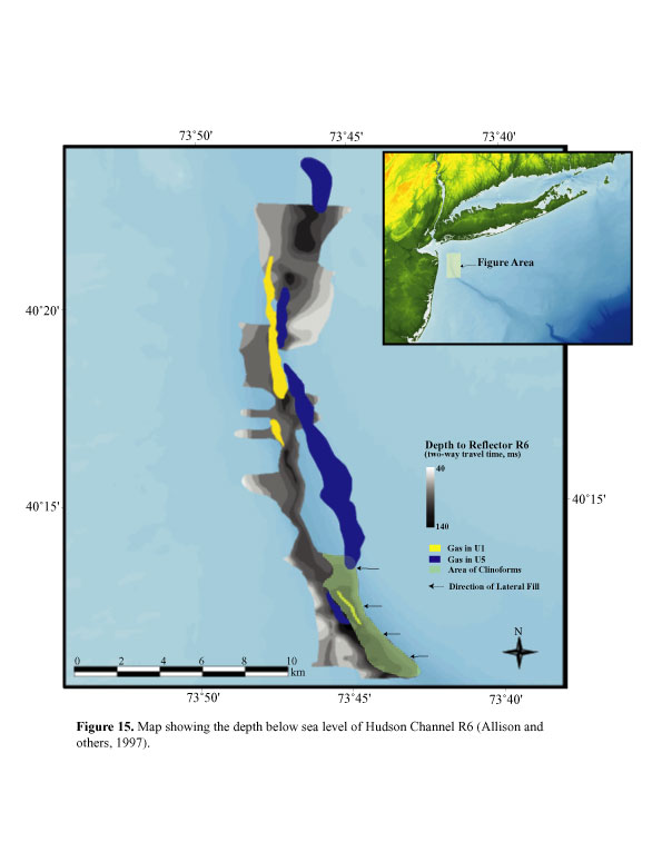
highs of coastal-plain strata in the Hudson Shelf Valley also caused
diversion of the Hudson Channel R6 and R5 complexes
(Figs.
15 and 16). Coastal-plain strata
(Figs. 2a and 4)
outcrops continue to be sites of sea bed erosion (Schwab and others,
1997a, 1997b, 1999, 2000a, 2000b).
The coastal-plain unconformity formed sometime between Late Cretaceous
and the Pleistocene. The irregular morphology and variety of units
overlying the unconformity suggest that this feature is a complex
surface that experienced several erosional episodes during different
Quaternary sea-level cycles. The relatively thin sedimentary deposit
above the coastal-plain unconformity on much of the inner continental
shelf (Fig. 10) indicates that most of
the Quaternary sediment bypassed the inner shelf via the major drainage
channels incised into the coastal-plain strata (Fig.
6, 15, and 16).
This complex evolution is exemplified by the fact that channels
R5, R6, and R7 incise the coastal-plain strata in portions of the
study area.
The large channel incised into the coastal-plain strata sub-parallel
to the modern shoreline of southern Long Island appears to extend
under western Jamaica Bay, as indicated by a few well logs (Fig.
6). These well logs suggest that this channel formed in the
Tertiary and later was modified by Pleistocene glaciation (Suter
and others, 1949; Williams, 1976). Thus, this channel is likely
filled with Quaternary and possibly some early Tertiary sediment.
We infer that the channel represents fluvial drainage from a pre-Wisconsinan
glacial event.
Fluvial drainage that formed the paleo-Hudson Shelf Valley also
may have incised the coastal-plain strata prior to the Pleistocene
(Soren, 1971; Lovegreen, 1974; Lotto, 2000). The actual location
of the Hudson Shelf Valley may have been structurally controlled
(Johnson, 1925). A fault, or series of en echelon faults, appears
to offset the U8 sediments on watergun profiles that cross the upper
Hudson Shelf Valley (Lotto, 2000, Figs. 6
and 13). The strike of the coastal-plain
strata varies from N70ºE west of the Hudson Shelf Valley, to N49ºE
east of the valley. This variable strike suggests some structural
control. Thus, the ancestral Hudson Shelf Valley may have been a
fault-controlled pathway for a succession of fluvial drainage systems,
including Pleistocene systems.
At 12,000-13,000 yr BP, the large glacial lakes north of the New
York Bight (Fig. 5) are thought to have
breached the moraine front at the Verrazano Narrows and other locations
in New Jersey and New York (Newman and others, 1969; Soren, 1971;
Lovegreen, 1974). Borehole data at the Verrazano Narrows indicate
that more than 100 m of Pleistocene and Cretaceous sediments, along
with most of the lacustrine sediment deposited the previous 8,000
yr, was eroded as a result of this breaching event(s) (Newman and
others, 1969). Uchupi and others (2000) and Driscoll and others
(2002) recently proposed that late Wisconsinan erosion of the Hudson
Shelf Valley and deposition of sediment lobes on the outer shelf
(catastrophic-flood morphologies) were a consequence of this catastrophic
drainage of glacial lakes. We propose that channels R6 and R5, and
possibly R4 (Figs. 13 and 14),
were cut by these catastrophic drainage events. Farther offshore
the bedform field found in the
 |
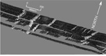
| Figure 19. Multibeam shaded relief image showing fields of bedforms in the lower Hudson Shelf Valley. Also link to larger image. |
lower Hudson Shelf Valley (Fig. 19) also
may be a product of the catastrophic introduction of this sediment-laden
water mass into the submarine section of the Hudson Shelf Valley (Thieler
and others, 1999b). The partial burial of up-valley portions of these
bedforms by Holocene sediment suggests the timing is appropriate.
Gas-charged sediments in CFU5 are an indication that organic-rich
sediment of estuarine origin is present. Further clarification of
the age and origin of these deposits requires data from boreholes.
The transgressive Holocene ravinement surface (Fig.
7), the next regional unconformity above the coastal-plain unconformity,
is relatively horizontal, and contains numerous, laterally continuous,
cut-and-fill structures in its upper section (Fig.
17). Sediment cores and grab samples have verified that the
Holocene ravinement surface originated during the Holocene marine
transgression. For example, red-stained, Pleistocene, fluvial gravelly
sands are exposed on the sea floor 3 km off Long Beach (Schwab and
others, 1997a, 2000a). Elsewhere, vibracores that penetrated the
Holocene ravinement surface bottomed in a mixed Holocene and older
shelly gravel unit that caps channel-fill (Lanier and others, 1999;
Lotto, 2000). We interpret the cut-and-fill structures in the upper
section of the Pleistocene sedimentary deposits that are truncated
by the Holocene ravinement surface to be part of a glaciofluvial
system that drained the southern shore of Long Island. Farther east,
off Fire Island, (Fig 3), similar cut-and-fill
structures were cored. These cores reveal that the cut-and-fill
structures are filled with a transgressive deposit of reworked Pleistocene,
glaciofluvial, gravelly deposits and early Holocene estuarine deposits
(U.S. Army Corps of Engineers, unpublished core data; Schwab and
others, 1999, 2000b; Foster and others, 1999).
A relatively thin Holocene sedimentary deposit blankets most of
the sea floor in the study area (Fig. 9).
Analysis of sidescan-sonar images and sediment samples shows that
these sediments were derived from reworking of the underlying Pleistocene
and Cretaceous deposits by Holocene oceanographic processes (Schwab
and others, 1997a, 1997b, 2000a; Lanier and others, 1999). The Holocene
sedimentary deposit is absent from, or extremely thin on, much of
the inner 6 km of the continental shelf off Long Beach, New York.
Sidescan-sonar images reveal a series of high-backscatter lineations
(Figs. 2a and 4)
caused by shallow depressions (<1-m-deep) floored with medium- to
coarse-grained sand (Schwab and others, 1997a, 1997b, 2000a). Multibeam
data show that the winnowed flanks of these low-amplitude, transverse
bedforms face into the dominant sediment-transport direction (Fig.
20). We suspect that these bedforms were caused by long-term
erosion of Pleistocene and early Holocene sediments on the inner-continental
shelf. The
 |
| Figure 20. Multibeam swath bathymetry and backscatter perspective image. Also link to larger image. |
fine- to medium-grained sand component (relatively low-backscatter)
is being transported generally along shore to the west, leaving behind
a medium- to coarse-grained, winnowed, lag deposit (high backscatter)
composed mainly of reworked fluvial gravels (Schwab and others, 1999,
2000a, 2000b). In short, the general morphology of the nearshore segment
of the inner continental shelf off Long Beach is a result of active
formation and modification of a Holocene ravinement surface.
Reflector R1, which separates CFU1 from the underlying component
of the Holocene deposit (Fig. 17), may represent a time-transgressive
boundary between an early Holocene marine transgressive unit, and
late Holocene unit CFU1, which is continuing to accrete or is, at
a minimum, mobile. CFU1 includes anthropogenic deposits derived
from offshore disposal of dredged sediments, construction debris
(HARS area), and sewage (Sewage Dumpsite) (Fig.
2a). CFU1 probably thickens in deeper water areas, but thicknesses
greater than 3 - 4 m could not be resolved on the CHIRP subbottom
data. In general, CFU1 is absent in water depths less than approximately
25 m. Surface-sediment mean grain size decrease slightly in water
deeper than approximately 24 m (from about 1.5 phi to about 2.5
phi) (Schwab and others, 1997a, 1997b, 2000a; Lanier and others,
1999). This decrease in grain size appears to correlate with the
presence of CFU1 at the sea floor, as opposed to exposures of older
units. The fine- to medium-grained sands of CFU1 are interpreted
to be, in part, winnowed products from the shallow-water areas (water
depth <24 m) of the inner shelf. Thus, CFU1 can be interpreted
as "modern" in the sense that there is net sedimentation. However,
the upper section of CFU1 may be mobile during severe storms (Butman
and others, 1979; Vincent and others, 1981). In the Sewage Dumpsite
( Figs. 2a and 4),
for example, sidescan-sonar backscatter patterns over a series of
sand waves (composed of fine-grained to very fine-grained sand,
Fig. 2a) have been interpreted to indicate
active sediment transport to the southwest, toward the Hudson Shelf
Valley (Schwab and others, 1997b, 2000a). Sediment mobility in this
area is further indicated by the burial and reworking of sewage
sludge material, as indicated by core data (Buchholtz ten Brink
and others, 1994, 1996).
The CFU1 found in the thalweg of the Hudson Shelf Valley has been
described as a sandy, organic-rich, black silt and is thought to
have, in part, originated from winnowing and transport of sewage
sludge from the Sewage Dumpsite (Buchholtz ten Brink and others,
1996; Lanier and others, 1999). The sandy silt to silty clay anthropogenic
layer in the bathymetric lows of the Hudson Shelf Valley is indicative
of the wide dispersal of CFU1 sediment (Buchholtz ten Brink and
others, 1996). Thus, the fine sand winnowed from the innermost shelf
and bathymetric highs (which are anthropogenic or stratigraphically
controlled deposits) today is, in general, deposited in water deeper
than ~25 m, whereas the muddy component is retained locally, but
ultimately accumulates in the Hudson Shelf Valley.
|