| |  |  | | Lake Pontchartrain Atlas: | | | | | | | | | | | | | | | | | | | | | | | | | | | | | | | Environmental Issues |  | | | | | | | | | | | | | |  | | | | | | | | | | |  | Environmental Issues - Coastal Land Loss Contributors: Zganjar circulation-patterns.html | Existing and Predicted Land Loss Trends 1956-2050 | 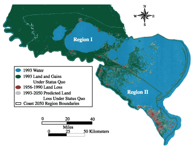 | Coastal Louisiana Land Loss Summary | | Description | Time Period | Mi2 | Km2 | | Historic Loss | 1956 - 1990 | 1286 | 3333 | | Coastal Land Lost Under Status Quo* | 1993 - 2050 | 990 | 2564 | | Coastal Land Saved with Coast 2050 | 1993 - 2050 | 660 | 1709 | | * CWPPRA Projects including Caernarvon and Davis Pond diversions | | Produced by the Louisiana Dept. of Natural Resources, Coastal Restoration Division and USGS National Wetlands Research Center, Coastal Restoration Field Station Data Sources: USGS National Wetlands Research Center:
1956 - 1990 Land loss data
Base map derived from 1993 GAP land cover data
1993 - 2050 with action predicted loss
Compiled for Coast 2050 by the Louisiana State University, Natural Systems
Engineering Lab and U.S. Army Corps of Engineers, New Orleans District Map-ID 2000-4-317
Map Date: 4/28/2000 | | | Figure 1: Historical and Predicted land loss and gains for two Coast 2050 regions in south-east Louisiana. Click on the map for a larger version. | « Previous | Next » |
