| |  |  | | Lake Pontchartrain Atlas: | | | | | | | | | | | | | | | | | | | | | | | | | | | | | | | Environmental Issues |  | | | | | | | | | | | | | |  | | | | | | | | | | |  | Environmental Issues - Aggregate Dredge Holes Contributors: Connor, Jr., Maygarden, Penland, Kindinger - Lake Pontchartrain Dredge Pit Bathymetry
In 1998, a partnership was formed between the UNOCRL and the USGS to collect hydrographic data along the south shore of Lake Pontchartrain in order to document bathymetric change since the early 1900's. These hydrographic data were processed and computer-generated to produce bathymetric maps. Locations of dredge-pits and specific study areas are shown in Figure 26. 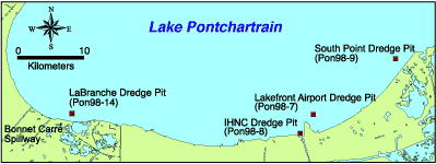 | | Figure 26: Lake Pontchartrain dredge pit locations. |  | | Figure 27: Trackline map with contour lines: LaBranche dredge pit. | 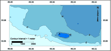 | | Figure 28: Filled contour map: LaBranche dredge pit. | 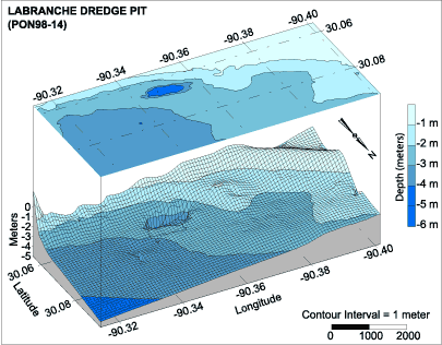 | | Figure 29: 3D bathymetric profile including filled contour map: Labranche Dredge Pit. | The bathymetric maps show an existing dredge hole approximately 5-meters (16.4 ft) deep located off the LaBranche shoreline near the Bonnet Carré Spillway (Figures 27, 28 and 29). This is one of four significant holes located along the south shore during this survey. This dredge hole was created during the dredging for the LaBranche Wetlands Marsh Creation Project (CWPPRA Project PO-17). T.L. James and Company began the work in November 1993 and it was completed in April 1994. Approximately 350 acres of marsh were restored by this project, which pumped 2,179.5 km3 (2,851,135 yd3) of material from the lake bottom (USACE communication). This filled a pond that was created by the flooding of a failed land reclamation project in the early 1900's. « Previous | Next » |
