| |  |  | | Lake Pontchartrain Atlas: | | | | | | | | | | | | | | | | | | | | | | | | | | | | | | | Environmental Issues |  | | | | | | | | | | | | | |  | | | | | | | | | | |  | Environmental Issues - Urbanization Contributors: Beall, Peters | Lake Pontchartrain Basin Population 1990 | 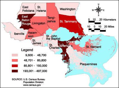 | Parish | Population 1990 | | Ascension* | 58,214 | | East Baton Rouge | 380,105 | | East Feliciana | 19,211 | | Iberville* | 31,409 | | Jefferson* | 448,306 | | Livingston | 70,526 | | Orleans* | 496,938 | | Plaquemines* | 25,575 | | St. Bernard | 66,631 | | St. Charles* | 42,437 | | St. Helena | 9,874 | | St. James* | 20,879 | | St. John the Baptist* | 39,996 | | St. Tammany | 144,508 | | Tangipahoa | 85,709 | | Washington | 43,185 | | * West banks of these parishes are not included in the Lake Pontchartrain Basin. | | | Figure 18: LPB parish population map for 1990. | | Lake Pontchartrain Basin Population 1999 | 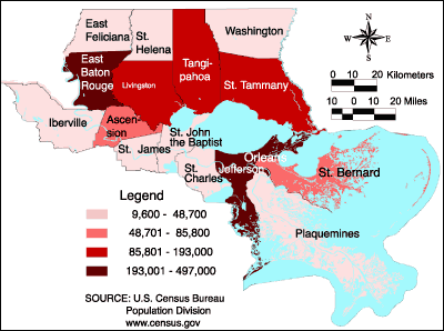 | Parish | Population 1999 | | Ascension* | 7,409 | | East Baton Rouge | 393,294 | | East Feliciana | 21,119 | | Iberville* | 31,357 | | Jefferson* | 447,790 | | Livingston | 91,182 | | Orleans* | 460,913 | | Plaquemines* | 26,094 | | St. Bernard | 65,406 | | St. Charles* | 48,640 | | St. Helena | 9,607 | | St. James* | 21,197 | | St. John the Baptist* | 42,494 | | St. Tammany | 192,945 | | Tangipahoa | 98,285 | | Washington | 43,162 | | * West banks of these parishes are not included in the Lake Pontchartrain Basin. | | | Figure 19: LPB parish population map for 1999. | | Lake Pontchartrain Basin % Population Change 1990 - 1999 |  | Parish | Population Change | | Ascension* | 27.2% | | East Baton Rouge | 3.5% | | East Feliciana | 9.9% | | Iberville* | 1.0% | | Jefferson* | -0.1% | | Livingston | 29.3% | | Orleans* | -7.2% | | Plaquemines* | 2.0% | | St. Bernard | -1.8% | | St. Charles* | 14.6% | | St. Helena | -2.7% | | St. James* | 1.5% | | St. John the Baptist* | 6.2% | | St. Tammany | 33.5% | | Tangipahoa | 14.7% | | Washington | -0.1% | | * West banks of these parishes are not included in the Lake Pontchartrain Basin. | | | Figure 20: LPB percent population change map (by parish) for 1990-1999. | | Lake Pontchartrain Basin Persons/Mile2 1999 | 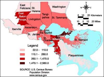 | Parish | Persons/Mile2 | | Ascension* | 253.9 | | East Baton Rouge | 863.0 | | East Feliciana | 46.6 | | Iberville* | 50.7 | | Jefferson* | 1463.8 | | Livingston | 140.7 | | Orleans* | 2552.1 | | Plaquemines* | 30.9 | | St. Bernard | 140.6 | | St. Charles* | 171.4 | | St. Helena | 23.5 | | St. James* | 86.1 | | St. John the Baptist* | 194.1 | | St. Tammany | 225.8 | | Tangipahoa | 124.4 | | Washington | 64.5 | | * West banks of these parishes are not included in the Lake Pontchartrain Basin. | | | Figure 21: LPB map showing persons/mi2 for each parish for 1999. | « Previous | Next » |
