| |  |  | | Lake Pontchartrain Atlas: | | | | | | | | | | | | | | | | | | | | | | | | | | | | | | | Environmental Issues |  | | | | | | | | | | | | | |  | | | | | | | | | | |  | Environmental Issues - Dredge Pit Characterization Contributors: Flocks, Franze 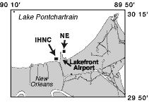 | | Figure 42: Dredge pit locations. | In the early 1930's several dredge pits were excavated along Lake Pontchartrain's south shore to provide material for land-fill projects adjacent to the Lake. The pits were dug down to the stiff clays of the Pleistocene surface 20-25 m (65.6-82.0 ft) below the Lake bottom. Two such pits were excavated to build up the south shore near the IHNC and the Lakefront Airport (Figure 42). The pit northeast of the Lakefront Airport (NE) has an area of approximately 0.45 km2 and extends over 14 m below the Lake bottom (Figures 43a and 43b). The pit adjacent to the IHNC is about 0.21 km2 and reaches 12 m below the Lake bottom (Figures 44a and 44b). Side-scan sonar and bathymetry surveys conducted over the pits reveal the steep slopes and intact structure retained from the dredging activities (Figures 43c and 44c). The shape of the pits restricts circulation, resulting in salinity stratification in the overlying water column. 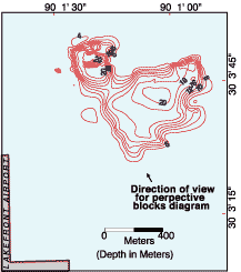 | | 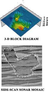 | Figure 43a: (above) Bathymetry at NE dredge pit.
Figure 43b: (top right) 3-D block diagram.
Figure 43c: (bottom right) Side-scan sonar mosaic. The dashed line outlines the dredge pit. | Since their excavations, the pits have essentially become giant sediment traps, slowly accumulating sediment from the surrounding Lake bottom. The IHNC pit has collected over 96,000 m3 since the 1930's, roughly an averaged accumulation rate of 1.5 cm/yr. Since the pits were dug in recent times, the composition of the infilling sediments includes material indicative of nearby metropolitan development. Such materials include trace metals and other pollutants (Flocks et al., in press). Saltwater from the Gulf of Mexico enters Lake Pontchartrain through the MRGO and the IHNC. This intrusion has caused significant stratification in areas of the southeastern portion of the Lake. A dense bottom layer of highly saline water wedges under the lighter, less saline surface water. As this stratified water mass spreads out, it enters the borrow pits and results in multiple layers of increasing salinity and decreasing dissolved oxygen to the bottom of the pits. The stratified bottom layer can become hypoxic or anoxic because mixing does not occur between the layers, thus restricting the input of atmospheric oxygen. Under anoxic conditions, decomposition by sulfate-reducing bacteria becomes the dominant biological process instead of oxygen-using decomposition. Detailed studies of the NE dredge pit included quarterly surveys of temperature, salinity and dissolved oxygen profiles in the water column. Additionally, benthic invertebrate community structure was investigated through bottom sampling which included the acquisition of long (vibracore) and short (boxcore) sediment cores. 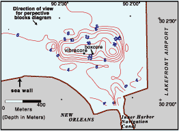 | | 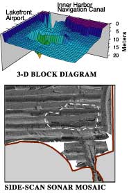 | Figure 44A: (above) Bathymetry at IHNC dredge pit.
Figure 44B: (above right) 3-D block diagram.
Figure 44C: (bottom right) Side-scan sonar mosaic. The dashed line outlines the dredge pit. | The water column profiles show that dissolved oxygen at the bottom of the NE pit was below 2 ppm during all but one quarterly sample in February 2000 (Figure 45). Salinity was stratified throughout the pit, ranging from 2.9 ppt to 12.7 ppt at the surface, to 15.8 ppt to 24.4 ppt at depth. The average salinity in Lake Pontchartrain is 4.0 ppt. Surface to bottom difference was as great as 17.7 ppt and complete mixing of surface and bottom waters was not detected. Temperature stratification was complex because the density differences were due mainly to salinity. This resulted in complex layers with warm saline bottom water (21ºC / 69.8ºF) occurring in January 1999, while surface temperature was 14ºC (58.8ºF). 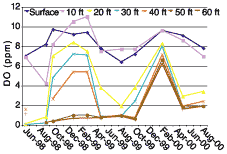 | | 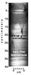 | Figure 45: (above) Dissolved Oxygen: NE dredge pit.
Figure 46: (right) X-radiograph of boxcore from IHNC dredge pit. |  | | Figure 47: Vibracore zinc (Zn) profile. | The benthic community in the NE dredge pit had few individuals and species when compared to samples taken from other areas of the Lake. Benthic samples contained mostly annelid worms (polychaetes and oligochaetes). The presence of this depauperate community, typical of a stressed environment, supports the theory that seasonal anoxia and hypoxia occur. The recent sediments accumulating in the pits are laminated and show minimal disturbance from water turbulence or bioturbation (Figure 46). Fine laminations are punctuated by occasional pulses of sandy material which constitute about 8% of the total accumulation. Down core trace metal profiles show decreasing concentrations with depth, consistent with metropolitan and industrial development of the south shore over time (Figure 47). « Previous | Next » |
