USGS Home - www.usgs.gov
Coastal and Marine Geology Program
Coastal & Marine Geology Program > Center for Coastal & Regional Marine Studies > Environmental Atlas of Lake Pontchartrain

Environmental Atlas of the Lake Pontchartrain Basin

Lake Pontchartrain Atlas Home
Lake Pontchartrain Atlas:
Preface
Table of Contents
Introduction
Environmental Overview
Environmental Status & Trends
Restoration
Physical Environments
Basin Geology
Biological Resources
Environmental Issues You are at the Environmental Issues section of the Environmental Atlas of Lake Pontchartrain
Bibliography
Resources
Contributors
Acronyms
Contact:
Jack Kindinger
Environmental Issues: Coastal Land Loss | Shoreline Change and Rates | Urbanization | Aggregate Dredge Holes | Dredge Pit Characterization | Bonnet Carré Diversion | Water Quality | Sediment Quality & Dispersal

Environmental Issues - Shoreline Change and Shoreline Change Rates

Contributors: Zganjar, Frierson, Westphal, McCarty, Bridges, Penland

Figure 4a: 1899 vs. 1995
Map showing shoreline changes of Lake Maurepas from 1899 to 1995.

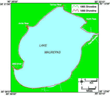
Figure 4b: 1930 vs. 1995
Map showing shoreline changes of Lake Maurepas from 1930 to 1995.

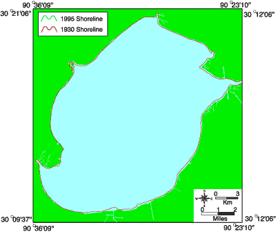
Figure 4c: 1960 vs. 1995
Map showing shoreline changes of Lake Maurepas from 1960 to 1995.

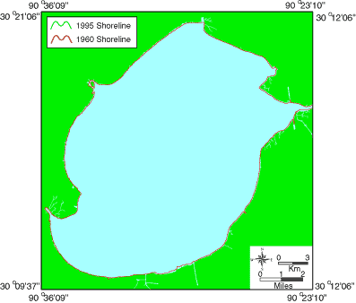
Figure 4: Shoreline position maps of Lake Maurepas comparing the years a) 1899 and 1995, b) 1930 and 1995, and c) 1960 and 1995.

« Previous | Next »


Coastal & Marine Geology Program > Center for Coastal & Regional Marine Studies > Environmental Atlas of Lake Pontchartrain

FirstGov.gov email Feedback [an error occurred while processing this directive]