| |  |  | | Lake Pontchartrain Atlas: | | | | | | | | | | | | | | | | Environmental Status & Trends |  | | | | | | | | | | | | | | | | | | | | | | | | | | | | |  | | | | | | | | | | |  | Environmental Status and Trends - Status and Trends of the Lake Pontchartrain Basin Contributors: Penland, Maygarden, Beall 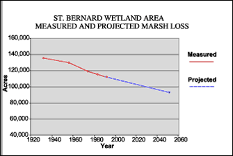 | | Figure 17: Measured marsh loss in the St. Bernard Wetland Area between 1932 and 1990 with projection to 2050 (Coast 2050, 1998). Refer to Table 5 for marsh loss comparison. | The St. Bernard Wetland Area (SBWA) encompasses 146,450 acres of marshes, bayous, shallow bays and ponds north of the MRGO channel between Lake Borgne and Chandeleur Sound (Figures 1 and 14). This combination of habitats has remained much the same since 1949. However, a large amount of marsh was lost to erosion in the latter part of the Twentieth Century. Construction of the MRGO altered the hydrology of the area by increasing the rate of erosion along the north bank of the channel. The channel was built to a width of approximately 152 m (500 ft), but in places in this area it has increased to approximately 10 m (2,000 ft) due to erosion by ship wakes. By allowing saline water across the natural ridge of Bayou La Loutre, the channel also introduces higher salinities to the more northern portion of the SBWA. Between 1932 and 1990, more than 23,000 acres of marsh were lost due to shoreline erosion, altered hydrology, direct removal and relative sea-level rise which is proceeding at between one and two feet per century (Figure 17). The SBWA is projected to lose another 19,230 acres of wetlands by 2050, due primarily to shoreline erosion and altered hydrology (Table 5). The St. Bernard Wetlands are extremely important habitat for a range of fish and wildlife species. Migratory waterfowl winter in this area, while a great variety of other migratory as well as resident birds, including the threatened brown pelican, depend on the rich food sources in the marsh. The combination of shallow open water, SAV and marsh creates the ideal nursery area for numerous recreationally and commercially important fishes, while larger lagoons and bays are prime oyster grounds. Within the St. Bernard Marsh Area is the 39,583-acre Biloxi Wildlife Management Area owned by Biloxi Marsh Company and managed by the LDWF. This is a very popular destination for recreational fishing boats. Tables 2, 3 and 4 summarize the status and trends of selected wildlife and fisheries populations of the area. Most fish and shellfish species have had steady populations numbers, but are projected to decline through 2050. The same is true for many of the bird species, both resident and migrant, with the exception of the brown pelican which is on the increase throughout the coastal areas. Alligators, as well as furbearers, are expected to continue a declining trend through 2050. « Previous | Next » |
