| |  |  | | Lake Pontchartrain Atlas: | | | | | | | | | | | | | | | | Environmental Status & Trends |  | | | | | | | | | | | | | | | | | | | | | | | | | | | | |  | | | | | | | | | | |  | Environmental Status and Trends - Status and Trends of the Lake Pontchartrain Basin Contributors: Penland, Maygarden, Beall The Central Wetland Area (CWA) encompasses 42,559 acres between the west side of the MRGO and the Forty Arpent Canal at the St. Bernard Parish hurricane protection levee (Figures 1 and 14). The Area consists primarily of brackish marsh with shallow open water ponds that contain SAV, agricultural land and uplands. The major habitat types in 1949 were swamp and freshwater marsh, but the construction of the MRGO brought rapid change in the 1960's. Spoil from the channel filled many acres of marsh, accounting for the single biggest loss in this area and allowing saline water to intrude via bayous and canals that cut through the spoil bank. The saltwater intrusion caused conversion of marsh to open water in many areas. Meanwhile, in the northwest corner near Bayou Bienvenu, a previously impounded area largely subsided into open water. 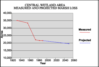 | | Figure 15: Measured marsh loss in the Central Wetland Area between 1932 and 1990 with projection to 2050 (Coast 2050, 1998). Refer to Table 5 for marsh loss comparison. | By 1974, the freshwater marsh had converted to brackish marsh or open water and the swamp had been greatly reduced. This change is reflected graphically in Figure 15, which shows a dramatic drop in marsh area between 1956 and 1974. By 1990, the area consisted of 21,600 acres of marsh and 90 acres of swamp. In addition to the impact of the MRGO and impoundment of marshes for agricultural use, storms and subsidence have taken their toll. The rate of relative sea-level rise is between 0.3 and 0.6 m (1.0 and 2.0 ft) per century here, making it a significant contributor. The CWA is predicted to lose another 9% of marsh acreage through 2050, although two restoration projects should reduce this loss rate (Table 5). One project diverts Mississippi River water via a siphon at the Violet Canal, while the other uses dredged material to fill the ponds resulting from impoundment. These projects are expected to reduce this future loss by about 50%. This area is important to many species of migratory and resident wading and water birds. Many shallow, open water areas filled with SAV make this an important wintering area for waterfowl and a nursery area for numerous recreationally and commercially important fish species. The status and trends of the fish and wildlife of the CWA are shown in Tables 2, 3 and 4. Generally steady populations of most species of fish and wildlife are seen in this area. Exceptions include American oysters, alligators and furbearers, which have decreased in number recently and are predicted to decrease through 2050. « Previous | Next » |
