| |  |  | | Lake Pontchartrain Atlas: | | | | | | | | | | | | | | | | Environmental Status & Trends |  | | | | | | | | | | | | | | | | | | | | | | | | | | | | |  | | | | | | | | | | |  | Environmental Status and Trends - Status and Trends of the Lake Pontchartrain Basin Contributors: Penland, Maygarden, Beall 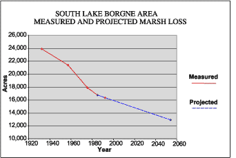 | | Figure 16: Measured marsh loss in the South Lake Borgne Area between 1932 and 1990 with projection to 2050 (Coast 2050, 1998). Refer to Table 5 for marsh loss comparison. | The South Lake Borgne Area (SLBA) encompasses the marsh between the MRGO and the Lake Borgne shoreline (Figures 1 and 14). This area is 27,219 acres in size and is mostly saline and brackish marsh with some open water. In 1949, all of the SLBA was brackish marsh, except for a small area of saline marsh at Proctor Point. Construction of the MRGO led to major losses of wetlands through direct removal and drastically altered the salinities and hydrology of the area. Since that time, the acreage of saline marsh has gradually increased, while total wetland acres have steadily decreased. Vessel traffic along the MRGO continues to erode many acres of marsh each year (Figure 16). Between 1932 and 1990, approximately 7,300 acres or 30.5% of the marsh was lost in this area, and it is projected that by 2050 a further 3,310 acres or 20% will be lost (Table 5). Erosion by ship wakes of the marsh adjacent to MRGO has been severe, with the channel width increasing three-fold in some places. Storms and an increase in the salinity of the area have also taken their toll. At the same time, the relative sea-level rise of between 0.3 and 0.6 m (1.0 and 2.0 ft) per century is a significant factor in the deterioration of this area. Restoration of the area is being attempted by strategically placing dredged material produced during channel maintenance, as well as armoring the MRGO shoreline. These measures are expected to have a small beneficial effect on these rapidly deteriorating marshes while wind, storms, altered hydrology and wave and wake erosion are expected to cause additional land loss in the future. The SLBA is important to many species of wildlife and fisheries, including migratory and resident waterfowl, wading and water birds, furbearers, shellfish and many recreational and commercial species of fish. The status and trends of a selection of the fish and wildlife of the area are shown in Tables 2, 3 and 4. Fish and shellfish populations, which have been generally steady, are expected to decline in the near future. This population trend is likely to apply also to many bird species, except for the brown pelican. « Previous | Next » |
